Early Views of the San Fernando Valley
| Historical Photos of the San Fernando Valley |
 |
|
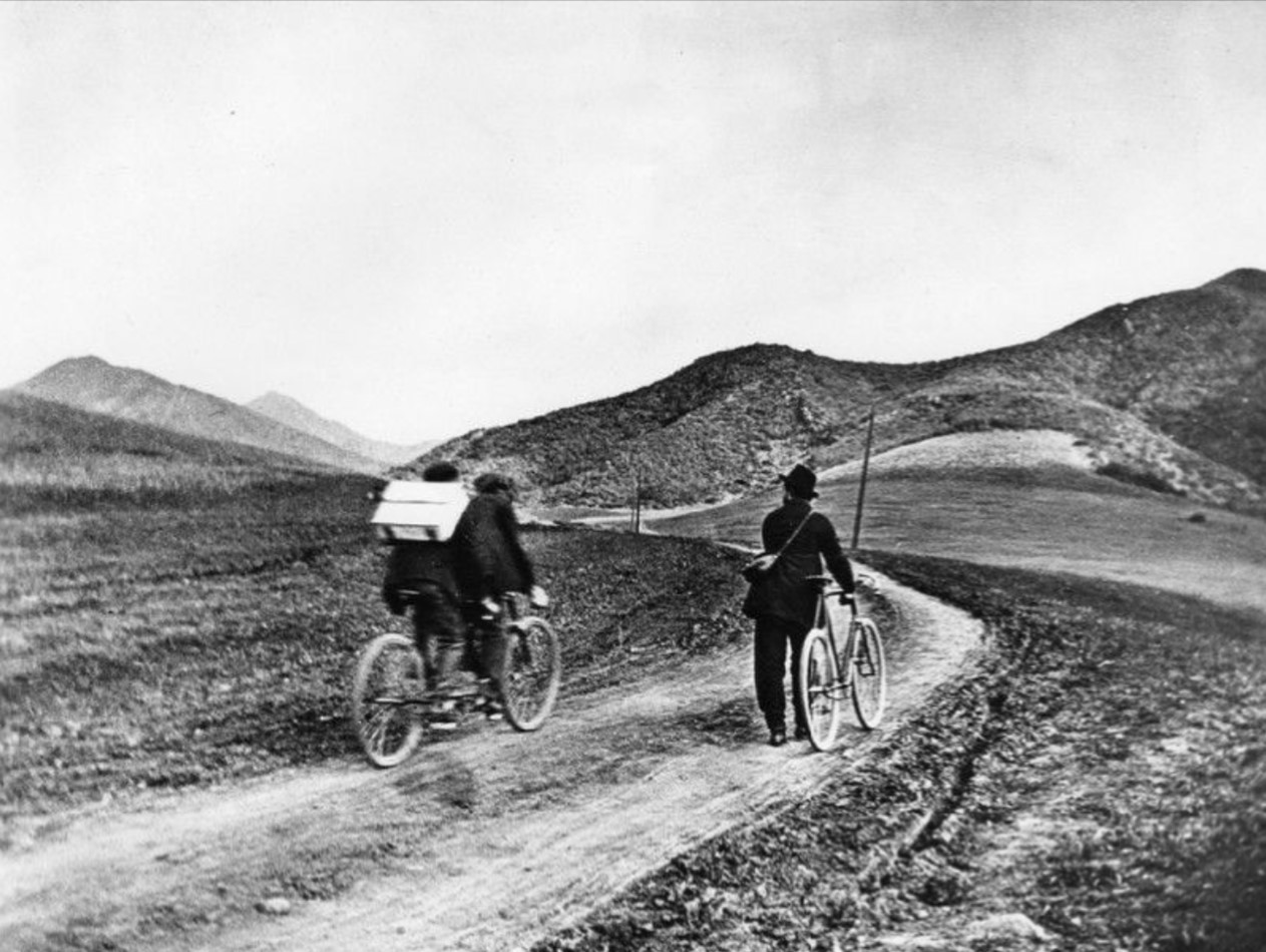
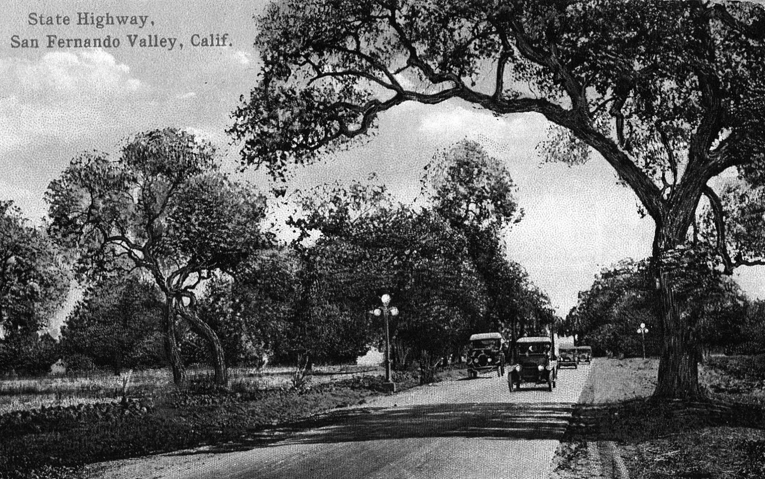
| (1901)* - Early travel through the Cahuenga Pass, which connected Hollywood and the San Fernando Valley, was done on bicycles by some. This area would later become Cahuenga Boulevard, just south of Whitley Terrace. |
Historical Notes The Cahuenga Pass connects the Los Angeles Basin to the San Fernando Valley and is the lowest pass through the mountains. Cahuenga is the Spanish name for the Tongva village of Kawengna, meaning place of the mountain. |
 |
|
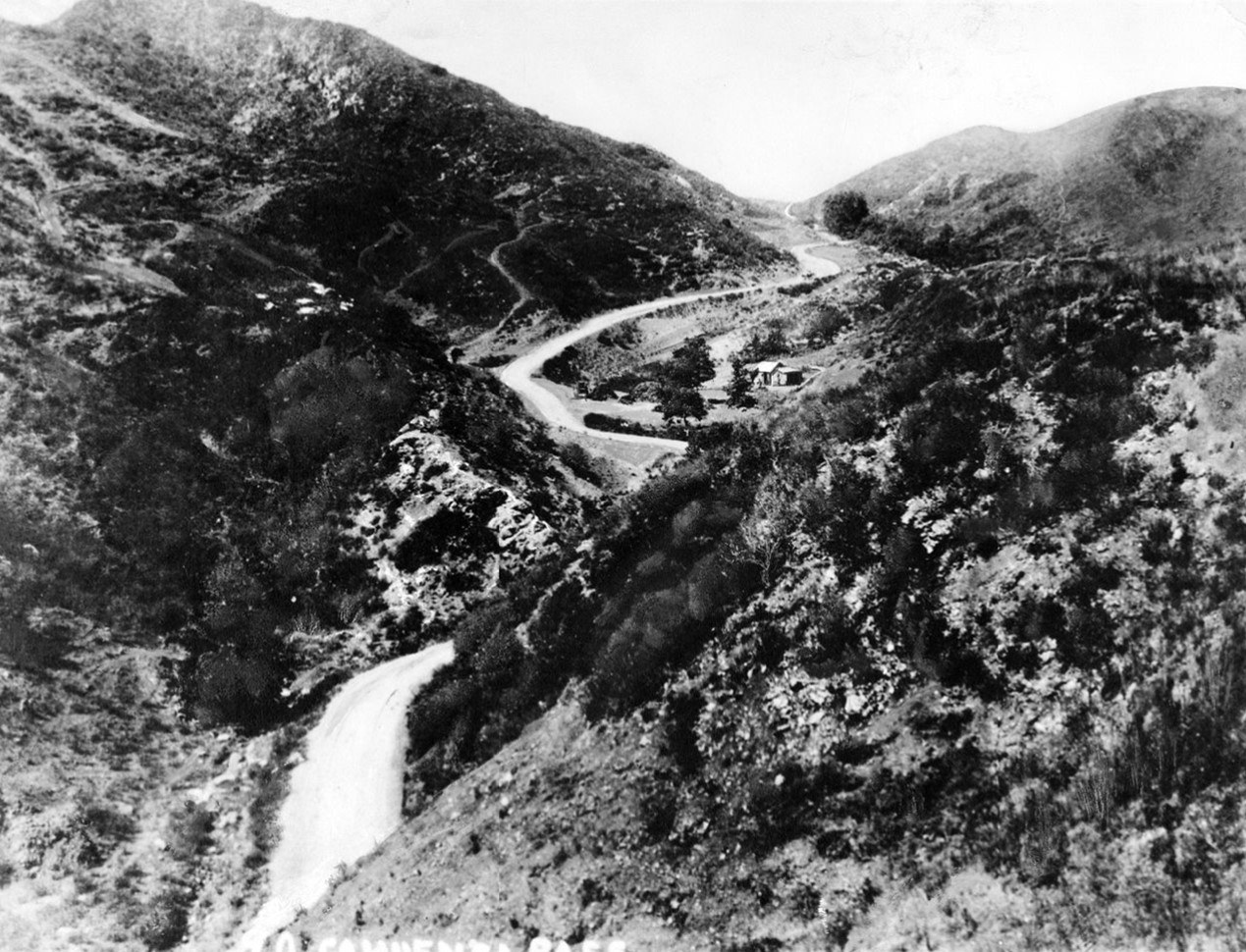
| (ca. 1890)* - High-angle view of Cahuenga Pass near North Hollywood, with road between mountains and stagecoach stop at right center. |
Historical Notes In the center of the photograph was a coach stop where people could stay overnight. It was owned by Geronimo Lopez. The road was narrow enough so that if two teams of horses met, the heaviest one won, the lighter one had to back down. Lightning would hit the horses during storms and was considered a very dangerous pass to cross. Miguel Leonis was killed in the Pass. |
 |
|
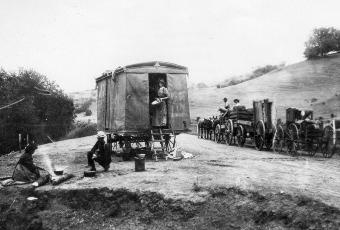
| (1892)* - Before roads and rail lines were built traveling through the Cahuenga Pass was by wagons and horses. Here a group of people have stopped to camp and cook something to eat. Another horse drawn vehicles passes them by on the road. |
Historical Notes During the 19th century, Cahuenga Pass saw significant development. By the 1850s, ox-carts and mule-teams were crossing the hills through the pass, and in 1858, the Butterfield Overland Mail Company stage made its first crossing. The 1870s brought the construction of the Pass Hotel, also known as Eight Mile House, which served as a toll station and store. |
 |
|
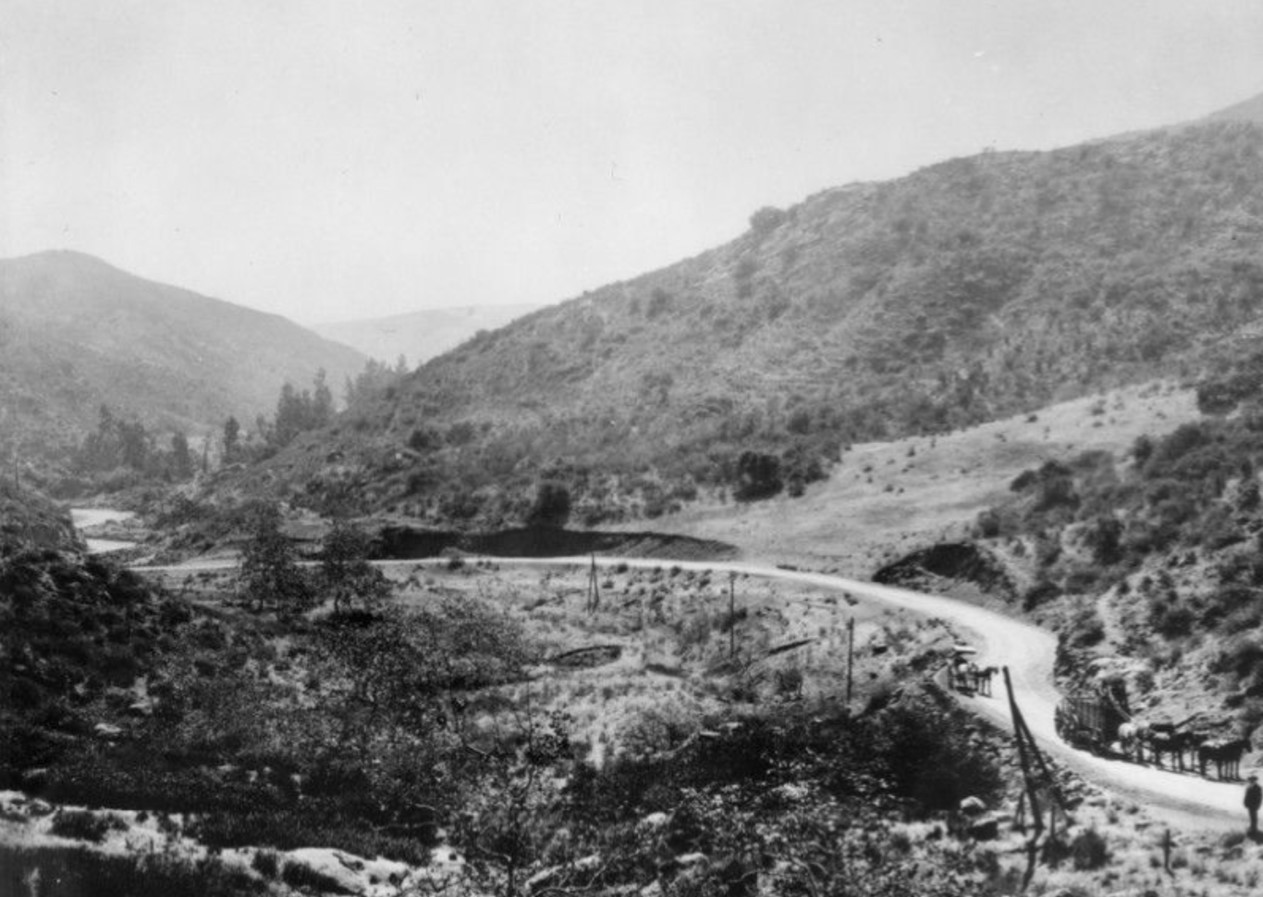
| (ca. 1894)* - Early view of area later to become part of the Cahuenga Pass. A road is visible in the photograph with what appears to be a horse-pulled buggy, and another team of horses in the lower right hand corner. |
Historical Notes Click HERE to see more Early Views of Cahuenga Pass |
* * * * * |
Farming in the San Fernando Valley
 |
|
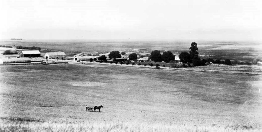
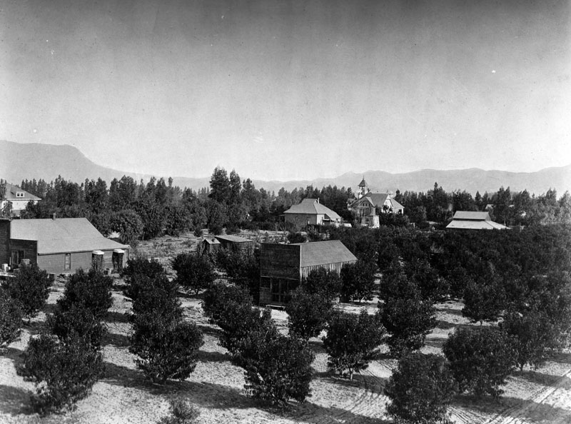
| (ca. 1890)* - Panoramic view looking north of the San Fernando Valley near Coldwater Canyon and Ventura Boulevard at what would become the site of the Hollywood Country Club. A man stands a distance away at center, trailing behind a horse-drawn cart. A large, flat field stretches out behind him, meeting several barns and a farm house in the distance, which is partially obscured by trees at the center. |
Historical Notes The valley was initially dominated by large cattle ranches, but in the late 1800s transitioned to wheat farming and the cultivation of a variety of crops including citrus, olives, walnuts, and other fruits and vegetables. This agricultural boom was enabled by the arrival of the Southern Pacific Railroad in 1876, which provided access to markets in San Pedro and San Francisco. By the 1880s, the Lankershim family's Los Angeles Farming and Milling Company was one of the largest wheat farming operation in the world, shipping their product as far as the UK. Other major crops included citrus, olives, and a wide variety of fruits and vegetables. |
 |
|
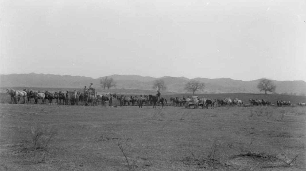
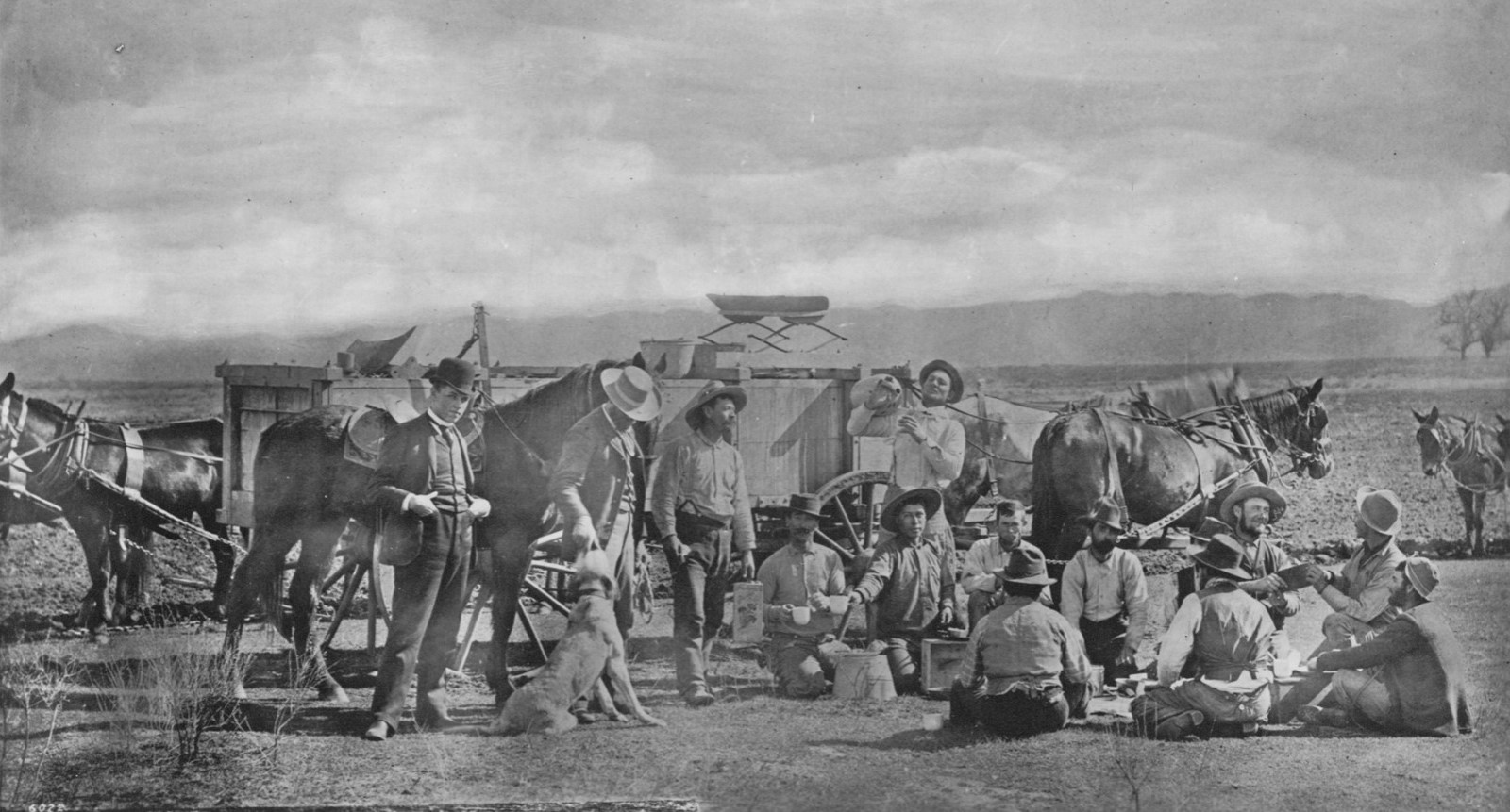
| (ca.1898)* – Panoramic view of a long row of horse-drawn wagons and men on horseback plowing and seeding 5,000 acres of wheat on the southeasterly portion of the Lankershim Ranch in the San Fernando Valley. Here the outfit is stopping for noon lunch in the fields. One hundred horses were used in this field for plowing. |
Historical Notes By the 1890s, a series of droughts led many farmers to adopt dry farming practices. This technique, developed on the Great Plains, was particularly suited to growing wheat and barley. In fact, the Los Angeles Farming and Milling Company, which owned a significant portion of the valley, became the world's largest wheat-growing empire. |
 |
|
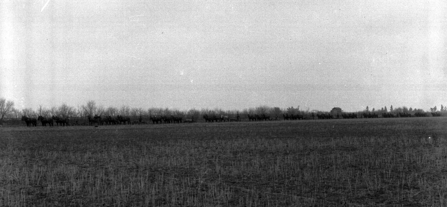
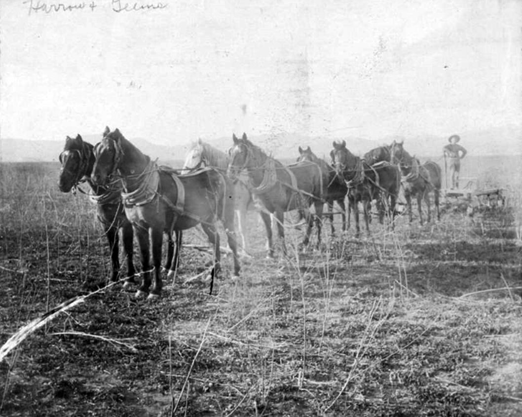
| (ca. 1900)* - Panoramic view showing 13 horse-drawn plows on Van Nuys grain ranch. Six horses and a driver are on each team. The long line of teams is lined up at the edge of a large field prepared to begin plowing for the day. A line of trees devoid of foliage is visible behind them. This wheat field is located in the southeasterly portion of the San Fernando Valley. |
Historical Notes Early plowing in the San Fernando Valley was done using horse-drawn plows. This method of plowing was labor-intensive but effective for preparing large tracts of land for cultivation. |
 |
|
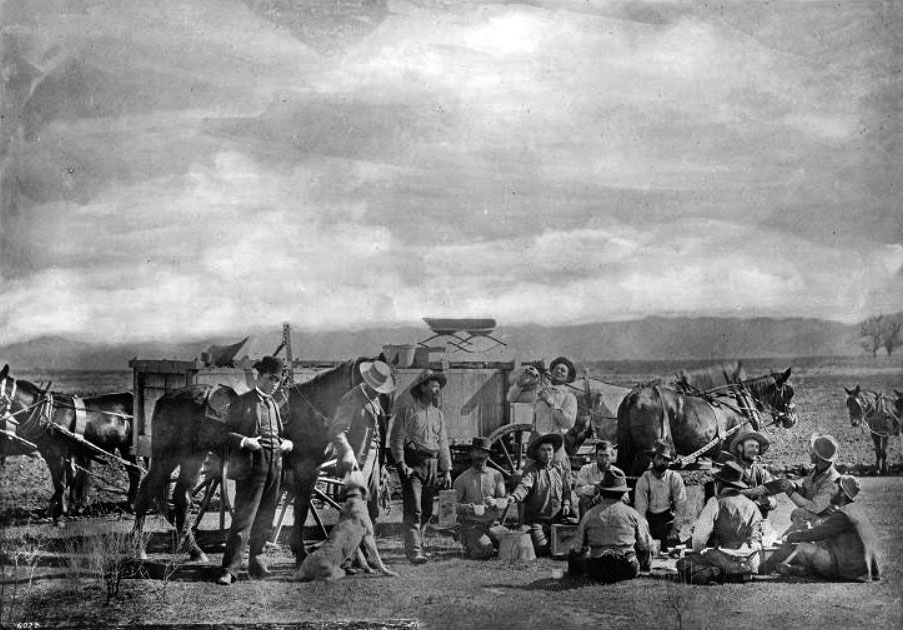
| (ca. 1900)* - Grub time on Van Nuys Ranch, eating in the field. About a dozen men and a dog take a break for a meal. Photo by C. C. Pierce |
Historical Notes Isaac Van Nuys’ great ranch eventually became the “Van Nuys townsite” and then simply, Van Nuys. No landmark house, statue, or even a formal portrait of the land baron remains. The only thing he left behind was his name. |
 |
|
| (ca. 1900)* - Grub Time at the Van Nuys Ranch - Men and Their Canine Companion Dine in the Field. Isaac Van Nuys’ great ranch eventually became the "Van Nuys townsite" and then simply, Van Nuys. No landmark house, statue, or even a formal portrait of the land baron remains. The only thing he left behind was his name. |
 |
|
| (ca. 1900)^ - Hubbard-Wright farming crew at work in Chatsworth. |
Historical Notes This team of men and machines harvested wheat for the ranches of the San Fernando Valley in the early 1900's. Mules were used to pull the equipment. The man on horseback at the lower right hand corner is J. R. Williams II. He was the supervisor in charge of the crew. He lived in Chatsworth. His mother and father came to the Santa Susana Pass area in the 1870's from Kansas. |
 |
|
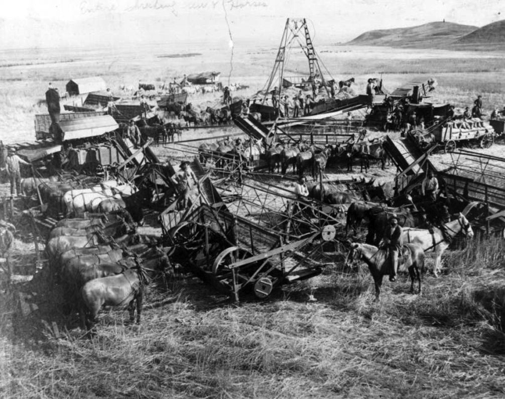
| (1890)* - Photograph of several threshing machines in the San Fernando Valley. Each thresher is hauled by a team of horses or mules. |
Historical Notes The adoption of threshing machines in the San Fernando Valley occurred in the late 19th or early 20th century, coinciding with the region's focus on grain production. These machines significantly increased efficiency in processing crops such as wheat, which was one of the valley's important products. |
 |
|
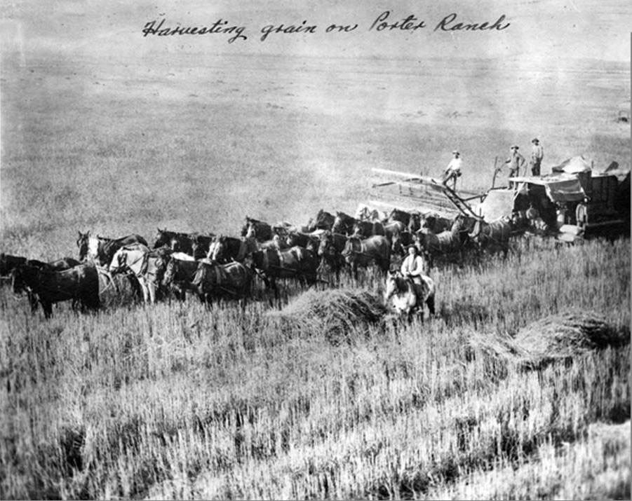
| (ca. 1900)^ - Farmers harvesting grain on Porter Ranch, circa 1900. |
Historical Notes The Porter Ranch was located in the northern part of present day Northridge and Granada Hills between Limekiln Canyon on the east and Aliso Canyon on the west side. The ranch was part of the 56,000-acre San Fernando rancho purchased by Senator Charles Maclay and George K. Porter in 1874 with George's cousin, Benjamin Porter, joining the partnership a few years later. |
 |
|
| (1890s)^ – View showing wheat farmer working the land belonging to B. F. Porter. |
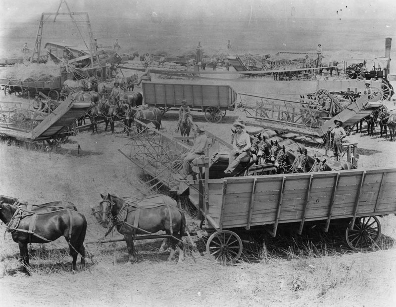
| (ca. 1898)* - Photograph of harvesters at work on a Van Nuys-Lankershim ranch in the San Fernando Valley. About 10 horse-drawn wagons are bringing the crop to a central belt-driven machine. A neatly pile of full burlap sacks can be seen with four men sitting on top. |
Historical Notes A group of investors assembled as the San Fernando Farm Homestead Association purchased the southern half of the Rancho Ex-Mission San Fernando. The leading investor was Isaac Lankershim, a Northern California stockman and grain farmer, who was impressed by the Valley's wild oats and proposed to raise sheep on the property. |
 |
|
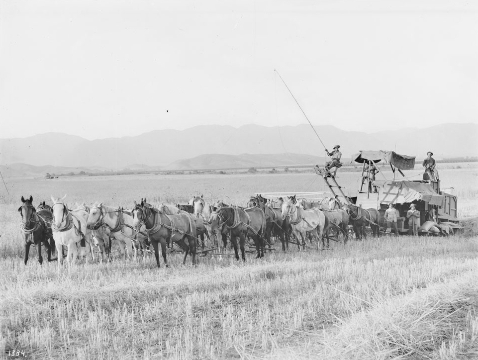
| (ca. 1905)* - A twenty-horse harvester at work in a field on a Van Nuys-Lankershim ranch in the San Fernando Valley, California, ca.1905-1908. It takes 5 men to operate the harvester. Mountains are visible in the distance. |
Historical Notes In 1873, Isaac Lankershim's son and future son-in-law, James Boon (J. B.) Lankershim and Isaac Newton Van Nuys, moved to the Valley and took over management of the property. Van Nuys thought the property could profitably grow wheat using the dryland farming technique developed on the Great Plains and leased land from the Association to test his theories. In time the Lankershim property, under its third name, the Los Angeles Farming and Milling Company, would become the world's largest wheat-growing empire. |
 |
|
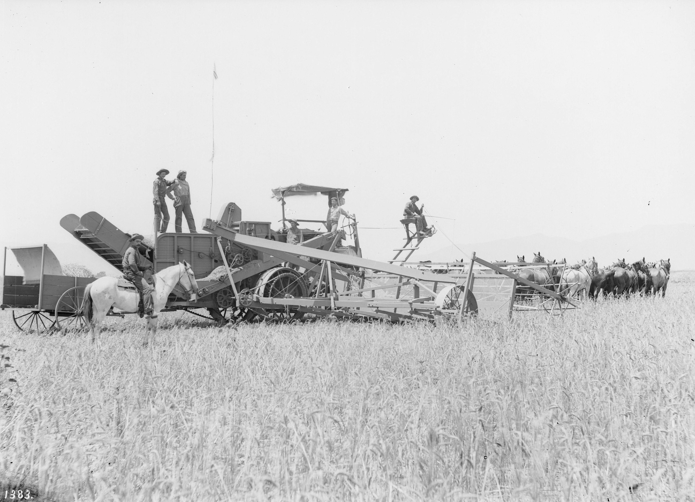
| (ca. 1890–1900)* – A horse-drawn combine harvester at work on a Van Nuys ranch in the San Fernando Valley. Multiple teams of horses pull the massive machine while laborers ride and operate its complex mechanisms to cut, thresh, and collect the wheat. |
Historical Notes The use of combine harvesters like this one signaled a leap forward in Valley agriculture. These early machines, powered by large teams of horses or mules, could reap, thresh, and winnow grain in a single pass, drastically reducing labor and time compared to earlier methods. While still reliant on animal power, they represented the start of a mechanized shift in Southern California’s wheat industry—an industry that, by the turn of the 20th century, was already exporting product overseas and transforming the San Fernando Valley into one of the most productive agricultural regions in the state. |
 |
|
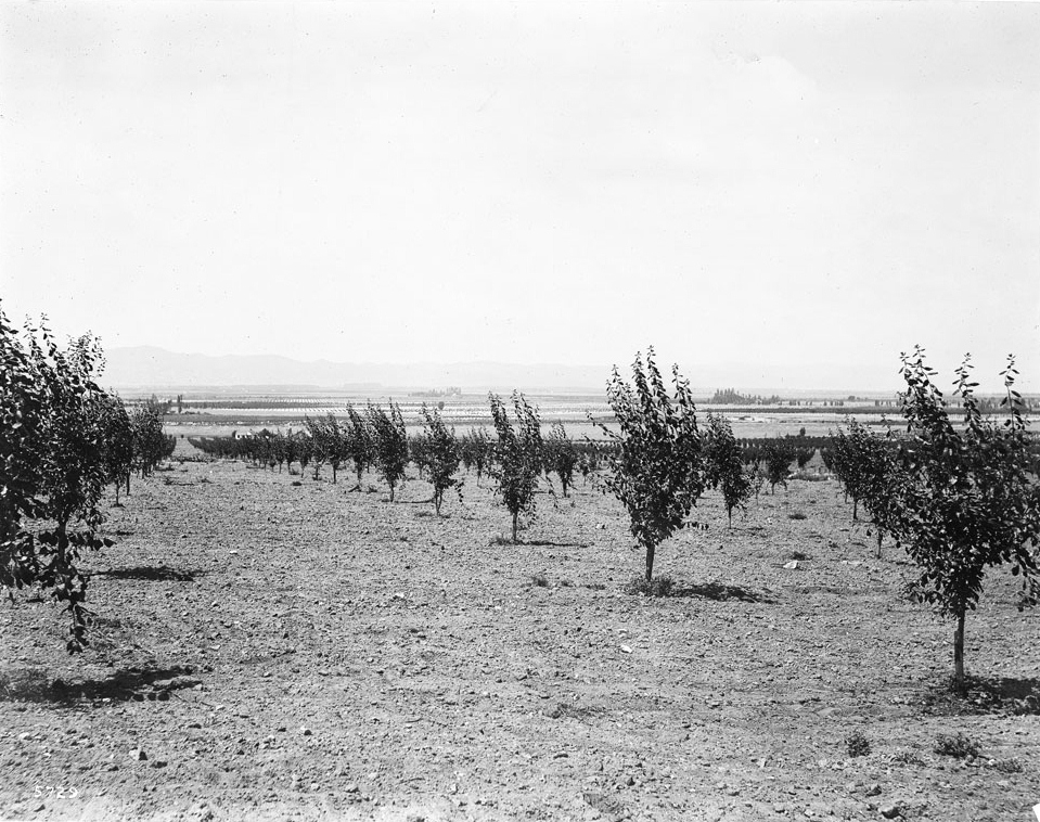
| (ca. 1900)* - Photograph of a view of a prune orchard in the San Fernando Valley. Rows of prune trees are planted in what appears to be dry and rocky soil. Aside from the prune trees, the landscape is pretty flat. Trees and grids of other types of crops are visible in the distance. |
Historical Notes The world wheat market remained strong through the 1870s and early 1880s, but then supply began to exceed demand, and prices began to fall. When the Santa Fe Railroad reached Los Angeles in 1885, fare wars between the Santa Fe and the Southern Pacific brought ever more settlers to Southern California, and pressure rose to subdivide the great ranches. In October 1887, J.B. Lankershim and eight other developers organized the Lankershim Ranch Land and Water Company, purchasing 12,000 acres north of the Cahuenga Pass from the Lankershim Farming and Milling Company. |
* * * * * |
Toluca
 |
|
| (1899)* - Toluca Road, now Lankershim Boulevard, in North Hollywood. |
Historical Notes J. B. Lankershim established a town site which the residents named Toluca along the old road from Cahuenga Pass to San Fernando. On April 1, 1888, they offered ready-made small farms for sale, already planted with deep-rooted deciduous fruit and nut trees—mostly peaches, pears, apricots, and walnuts—that could survive the rainless summers of the Valley by relying on the high water table along the Tujunga Wash rather than surface irrigation. |
 |
|
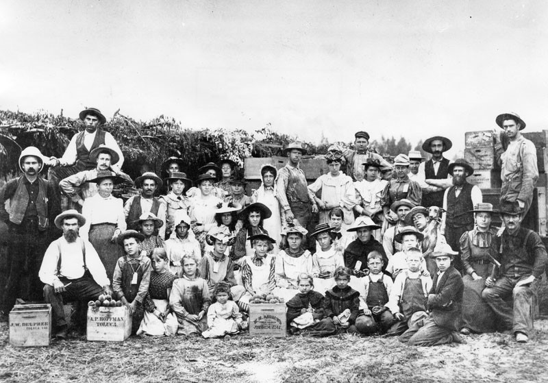
| (1890)* - A group of agricultural laborers take a break from harvesting peaches to pose for the camera, in the Toluca area of the San Fernando Valley. 'Toluca, Ca.' is printed on the side of the peach boxes. |
Historical Notes North Hollywood was established by the Lankershim Ranch Land and Water Company in 1887. It was first named Toluca before being renamed Lankershim in 1896 and finally North Hollywood in 1927. ^ |
| (ca. 1912)* – Postcard view showing six horse-drawn wagons carrying sacks of walnuts for shipping in Lankershim (now North Hollywood). |
 |
|
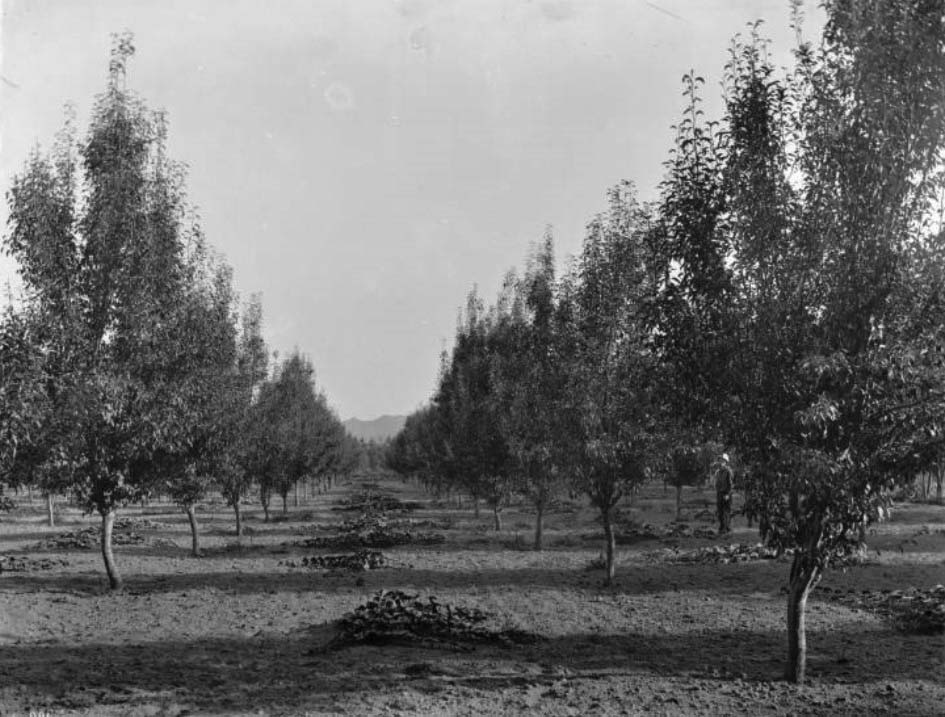
| (ca. 1900)* – Anderson's pear orchard, Toluca (Lankershim), San Fernando Valley. View is down the space between two long rows of trees. A man is standing at right and the silhouette of mountains is visible in the distance. |
Historical Notes The land boom of the 1880s went bust by the 1890s, but despite another brutal drought cycle in the late 1890s, the fruit and nut farmers remained solvent. The Toluca Fruit Growers Association was formed in 1894. The next year the Southern Pacific opened a branch line slanting northwest across the Valley and stopping at Lankershim on its way to Chatsworth. |
 |
|
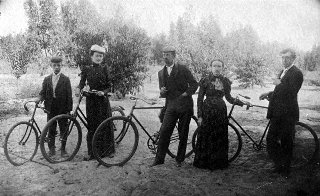
| (ca. 1900)^ - The Van Winkle Family posing with their bicycles in Lankershim (now North Hollywood). Seen above are father, Andrew Van Winkle, mother, Amanda Van Winkle, oldest daughter, Mae, and two sons, Ralph and Arthur Ado. |
Historical Notes The Van Winkle Family was active in the Lankershim community. |
Lankershim Station
 |
|
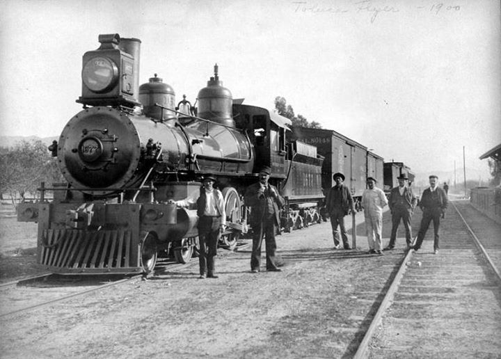
| (1900)*^^^ - This is the "Toluca Flyer" at the Lankershim Station in 1900. |
Historical Notes In 1895, the Southern Pacific opened a branch line slanting northwest across the Valley to Chatsworth. The Chatsworth Limited made one freight stop a day at Toluca, though the depot bore the new name of Lankershim. With the Post Office across the street called Toluca, controversy over the town’s name continued and the local ranchers used to quip, “Ship the merchandise to Lankershim, but bill it to Toluca.” In 1896, under pressure from Lankershim, the post office at Toluca was renamed "Lankershim" after his father, although the new name of the town would not be officially recognized until 1905.*^ |
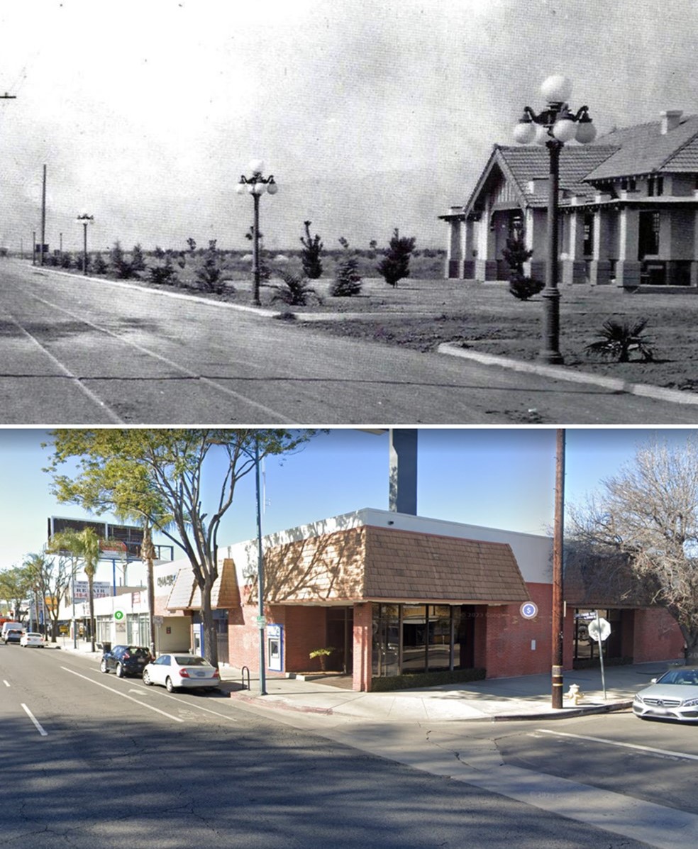
| (1927)* - Exterior view of the Lankershim (later North Hollywood) station of Southern Pacific and Pacific Electric railways. |
Historical Notes When it first opened in 1895, the train depot at the corner of Lankershim Boulevard and Chandler Boulevard was crucial to the rapid growth of the town that was first called Toluca, then Lankershim, and finally, North Hollywood. The depot still stands today, and is one of the oldest existing structures in the San Fernando Valley. It has been named a cultural and historic monument by the city of Los Angeles and is slated to be restored. Click HERE to see more of the North Hollywood Pacific Electric Station. |
* * * * * |
Mail and Stage Service
 |
|
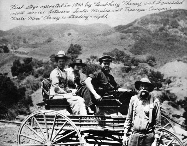
| (ca. 1880s)^ - First stage and mail service operated in 1880s between Santa Monica and Topanga Canyon. |
Historical Notes The 1st mail wagon was established by "Aunt Lucy" Cheney and began service in 1880. It provided mail service between Santa Monica and Topanga Canyon. They began to carry passengers (as shown here) in 1885. Also pictured is "Uncle Mose" Cheney.*^^^ Possible Correction (not yet verified): |
* * * * * |
Vejar Stage Station (Agoura)
 |
|
| (ca. 1886)^^ - Exterior view of Crisostona Vejar Stage Station on Ventura Road. The station, built in 1820 by the family of Thomas Delano and Crisostona Vejar, is a two-story wooden building with a covered porch and balcony. The Vejar Station was located at the present city of Agoura. |
Historical Notes In its earliest days, Agoura Hills was nothing more than a stagecoach stop and was referred to as "Vejar Junction." In the early 1920s, after Paramount Studios purchased a ranch in the neighborhood, the community became known briefly as "Picture City." But neither name stuck. In 1928, a group of residents formed a Chamber of Commerce which, as one of its first actions, asked to have a permanent post office established in the community. The Postal Department informed the chamber that it would need to submit a list of ten potential names for the town. One of the area's more colorful early landowners had been a man by the name of Pierre Agoure. Though French by birth and a shepherd in his youth, he favored Spanish costumes and adopted the moniker Don Pedro Agoure. In compiling a list of possible names, the townspeople inserted "Agoure" in the tenth spot. Bob Boyd, the town's first postmaster, later recalled that the tenth name was selected because it was the shortest. How the "e" became an "a" remains an unsettled issue. Some say it was done intentionally for ease of spelling, others lay blame at the door of the post office, arguing that the modification was simply an error.*#^* |
El Camino Real
 |
|
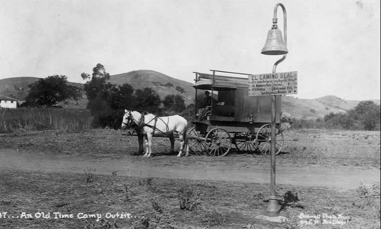
| (ca. 1900)^ - An old time camp outfit near Ventura Boulevard and Valley Circle Boulevard. Leonis Adobe is in the background. On the El Camino Real sign it says, "83.9 Santa Barbara, 18 Newberry Park, 47.9 Ventura, Los Angeles 26.1, Encino 8, Hollywood 19.6, San Fernando Mission 14." The El Camino Real bells were placed along the mission routes. |
Historical Notes Ventura Boulevard is the oldest continuously traveled route in the Valley. Laid out to follow a portion of the Spanish settlers' famed El Camino Real, it has been known as Camino de las Virgenes, U.S. highway 101 and Ventura Road.^* |
 |
|
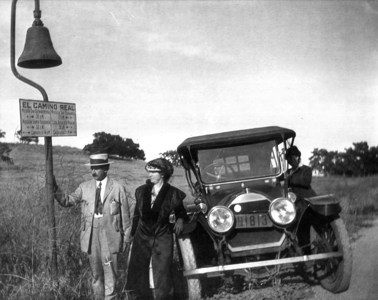
| (1906)* - A man holds onto the base pole of the El Camino Real Mission Bell Marker. Two women near a late model car observe. |
Historical Notes In 1906, members of the L.A. Chamber of Commerce and the Southern California Automobile Association began placing facsimile mission bells along the El Camino Real. The road, called "the royal road" in Spanish, was built to connect the network of missions, presidios and pueblos in Baja and Alta California. Today, the path of El Camino Real is roughly mirrored by US Highway 101.* |
* * * * * |
Leonis Adobe
 |
|
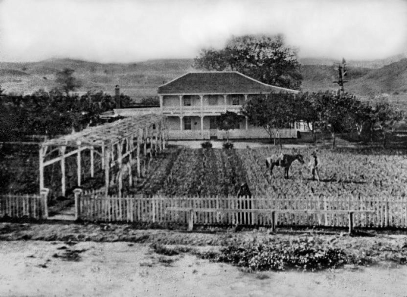
| (ca. 1900)* - The Leonis Adobe as it appeared around 1900. A man stands in the field beside his horse. If you look closely, a woman is standing just behind the fence at center, looking toward the photographer. She is believed to be Espiritu Leonis, the partner and later legally recognized common law wife of Miguel Leonis. |
Historical Notes El Escorpion, also written as El Scorpion, was a large ranch in the west San Fernando Valley. It was granted in 1839 to three Native residents of Calabasas who were connected to Mission San Fernando. The land later passed to Espiritu, daughter of one of the original grantees. In the late 1860s, the Basque rancher Miguel Leonis became involved with Espiritu, whose inherited rights allowed him to gain control of the ranch and expand it into a major cattle and sheep operation. He later became known locally as the King of Calabasas. By the time of his death in 1889, the ranch extended to more than one thousand acres. The Leonis Adobe was built in 1844 and is one of the oldest standing private residences in Los Angeles County and one of the oldest buildings in the San Fernando Valley. Although the original structure was a simple adobe room, Leonis expanded it over time with wood frame additions and Victorian details. After his death, the property became the center of a long legal battle between Espiritu, Leonis family members in France, and a daughter born out of wedlock. In 1905 the courts finally recognized Espiritu as his lawful partner and awarded her the estate. |
Then and Now
 |
|
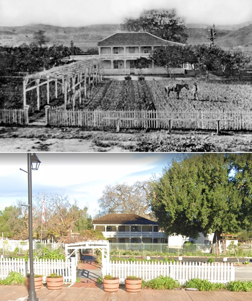
| (1900 vs 2023)* – The 1844 Leonis Adobe in Calabasas. It remains one of the oldest houses in Los Angeles County. In 1962 it became the very first building in Los Angeles to be designated a Historic Cultural Monument. Photo comparison by Jack Feldman. |
Historical Notes By the early 1900s the Leonis Adobe was already recognized locally as one of the last surviving ranch homes from the Mexican and early American periods of the San Fernando Valley. Its appearance changed over time as the ranch lands around it were divided and Calabasas began to grow. Public interest in preserving the adobe increased in the 1950s and early 1960s as the Valley rapidly modernized. This led to its designation in 1962 as the very first Los Angeles Historic Cultural Monument. Later restoration work brought back many of the building’s nineteenth century features. Today the adobe is an important reminder of the early ranching history of the west Valley and the life of Miguel and Espiritu Leonis during the transition from Spanish and Mexican land grants to American settlement. |
 |
|
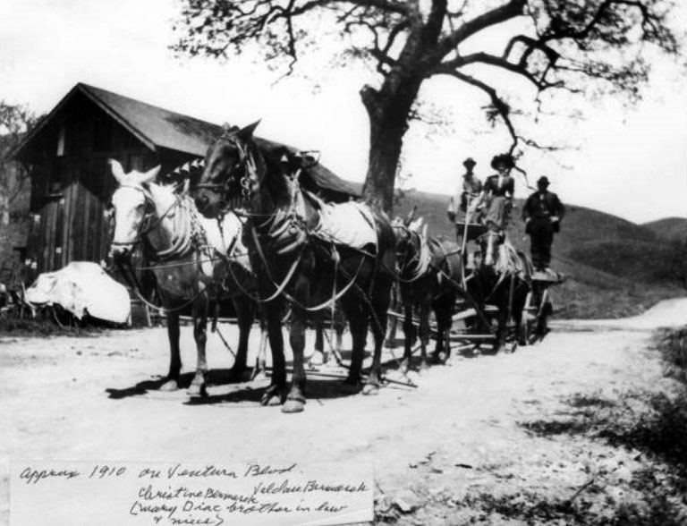
| (ca. 1910)#^ - Christine Bermark, Valdau Bermark, and an unidentified man on Ventura Boulevard. At that time this stretch of the road still ran across the old Leonis Adobe ranch lands. Ventura Boulevard was a rural wagon road in 1910 and was not fully paved until the mid 1910s. |
Historical Notes Around 1910 Ventura Boulevard was still a rural road that followed the line of the old El Camino Real route through Calabasas. It passed directly through land once worked as part of the Leonis Adobe ranch. The road carried wagons, stagecoaches, and early automobiles traveling between the growing towns of Los Angeles and Ventura. The Bermark family photograph reflects a moment when Calabasas was shifting from an isolated ranching community to a roadside settlement supported by travelers. Paving of Ventura Boulevard began only a few years later and helped bring steady development to the area. The open landscape seen behind the group gives a good sense of how much of the Leonis ranch had already been cleared and fenced as the region moved toward small farms, roadside businesses, and the beginnings of suburban growth. |
 |
|
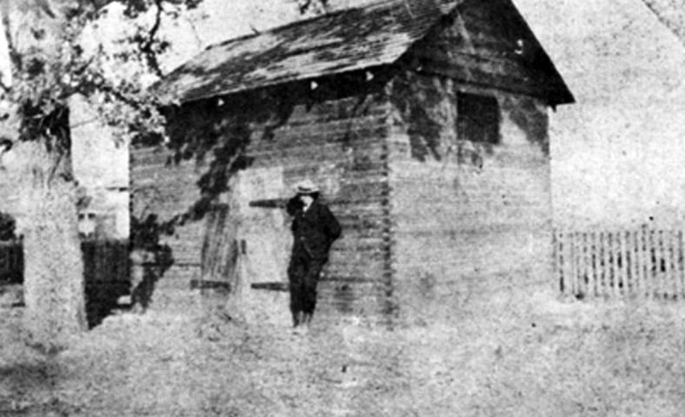
| (ca. 1902)^ - A man leaning against the Calabasas jail house. A corner of the Leonis Adobe can be seen between the hangmans tree and the jail. |
Historical Notes The Calabasas jail house was built in 1869 and served the small frontier settlement when Calabasas was a stagecoach stop along the road between Los Angeles and the Ventura coast. The jail was moved to Chatsworth in 1902 and was torn down in 1910. The property now occupied by the Sagebrush Cantina originally held a group of small stores built by Lester Agoure Sr. in the early 1920s. The parking lot once held the town jail. The dead hangmans tree, which still stands today, later became the symbol of the Calabasas Chamber of Commerce. |
 |
|
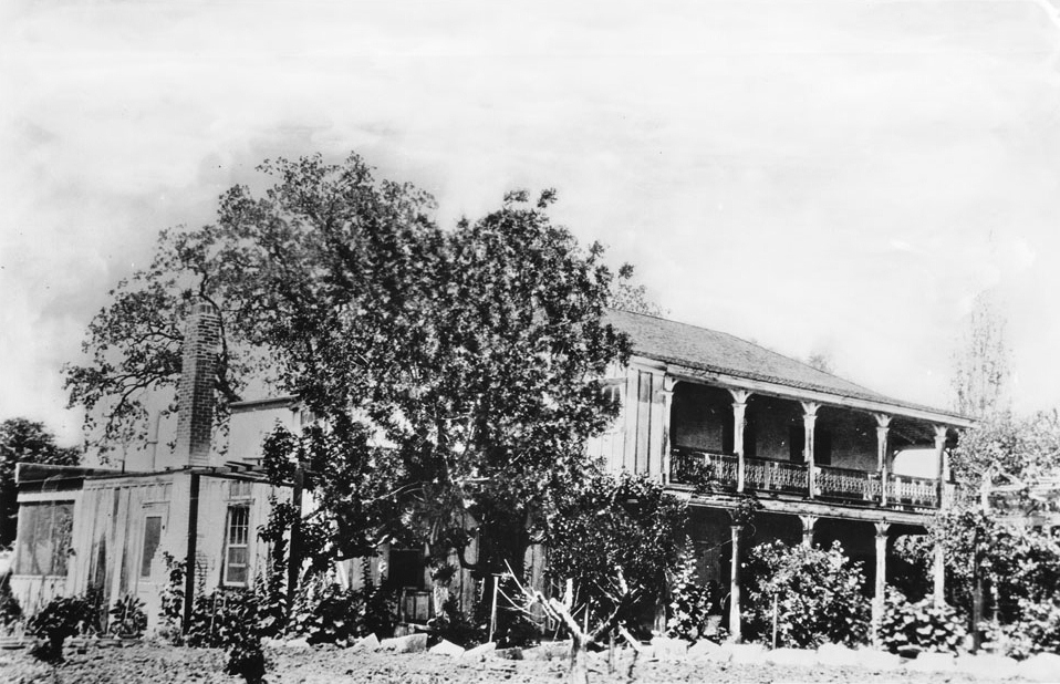
| (ca. 1915)* - The Leonis Adobe around 1915. The two story home has a covered porch and balcony on the right, along with a brick chimney. Although known as an adobe, much of the visible structure is wood, added during later remodeling. Trees and thick landscaping partly hide the front of the house, a common practice meant to block dust from nearby ranch activities. |
Historical Notes By the early 1960s the adobe had been damaged by neglect and vandalism. In 1961 the owner applied for a permit to demolish the building and replace it with a supermarket. Preservation advocates stepped in and succeeded in having it declared a Historic Cultural Monument in 1962, the first structure in Los Angeles to receive that designation. The Leonis Adobe is also known for its long history of reported ghost stories and was featured in the British television series Most Haunted in 2005. The property was restored and now operates as a living museum of early ranch life in the San Fernando Valley. It was added to the National Register of Historic Places in 1975. Click HERE to see the LA Historic-Cultural Monuments List. |
* * * * * |
Weddington Bros. Store
 |
|
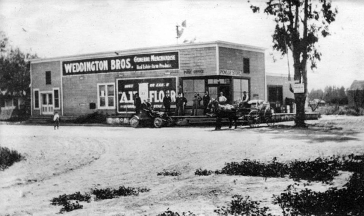
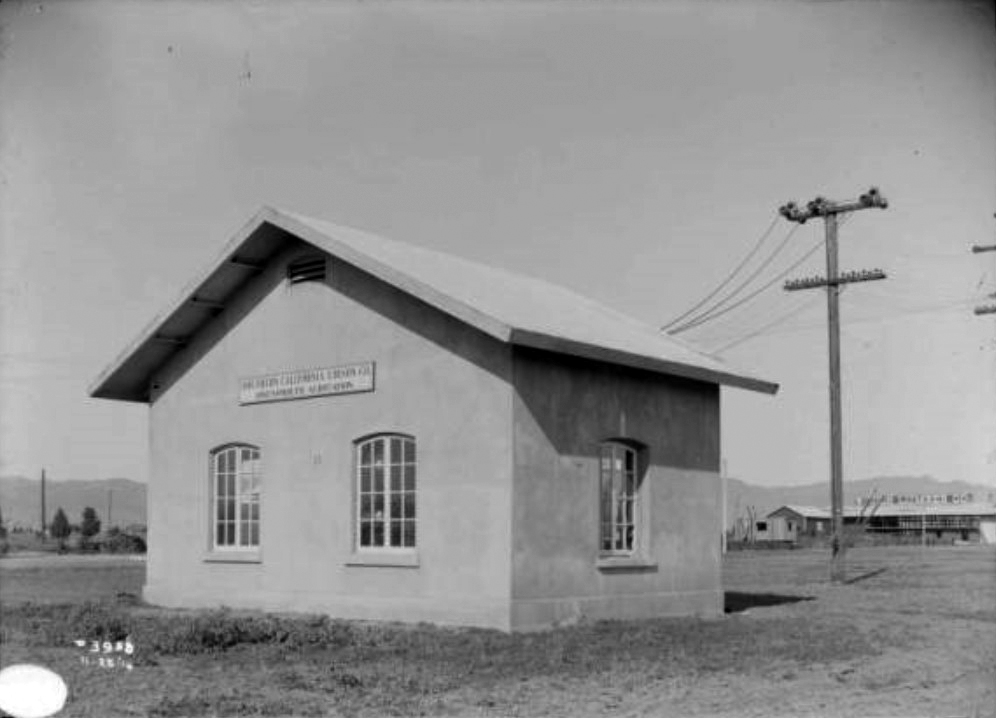
| (1905)#^ - The Weddington Bros. General Merchandise Store was established in the 1890s and was stocked with groceries and dry goods. The store was owned by Wilson C. Weddington who was a very prominent citizen and civic leader of North Hollywood. |
Historical Notes Wilson C. Weddington was an important figure in the Valley. He established the Weddington Store in the 1890's and was influential in establishing North Hollywood, serving as President of the Chamber of Commerce from 1927 to 1929. He purchased 12 acres of land at $60 an acre, later purchasing an additional 20 acres.*^^^ |
Whitley Mansion
 |
|
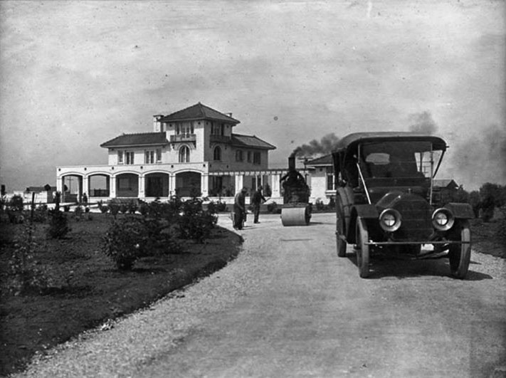
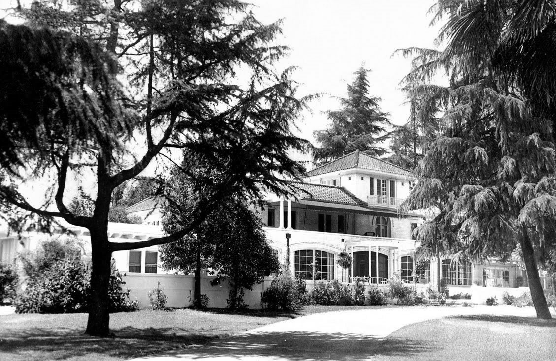
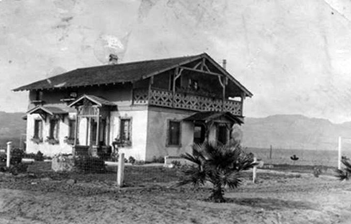
| (ca. 1910)*^^^ - View of the Whitley Mansion located at 5849 Van Nuys Boulevard. Two men are standing on the driveway next to a steamroller that has smoke billowing out of its stack. On the right, a man is seen behind the wheel of an early model automobile. |
Historical Notes Hobart Johnstone Whitley, also known as H.J. Whitley and the "Father of Hollywood", was a real estate developer who helped create the Hollywood subdivision in Los Angeles. He is also known for helping develop the San Fernado Valley. After Whitley saw the San Fernando Valley and heard of Mulholland's ideas for a new aqueduct, he began discussing opportunities with business associates in Los Angeles. The city's approval of the Los Angeles aqueduct project in 1905, with a proposed terminus in the San Fernando Valley, inspired the formation of a land speculation syndicate, the Los Angeles Suburban Homes Company. Its partners included Whitley, Isaac Newton Van Nuys, General Moses Sherman, James Boon Lankershim, and Harry Chandler, manager of the "Los Angeles Times," as director. The Los Angeles Suburban Homes Company syndicate purchased the 47,500-acre parcel from the Los Angeles Farming and Milling Company, owned by Van Nuys and son-in-law Lankershim, in 1909. It comprised nearly the entire south half of the San Fernando Valley (south of present day Roscoe Blvd.). The price was $2,500,000, or just under $53 an acre. On the land he planned the new towns of Van Nuys, Marian (present day Reseda), and Owensmouth (present day Canoga Park and West Hills. Though located 15 miles to the southwest, Owensmouth was named for the new Owens River aqueduct's terminus/mouth in the northern valley, that opened in 1913. The Janss Investment Company was contracted for developing and promoting Van Nuys and Owensmouth.*^ |
 |
|
| (ca. 1920s)^^# – View of the Whitley Mansion of Van Nuys, later to become a funeral home. |
Historical Notes The Whitley Mansion was eventually sold to the Praiswater Family and in 1939 became the Praiswater Funeral Home. Keyes Toyota Dealership on Van Nuys Boulevard now stands where the Whitley - Praiswater Mansion once graced the San Fernando Valley. No trace of the original structure remains today. |
* * * * * |
.jpg) |
|
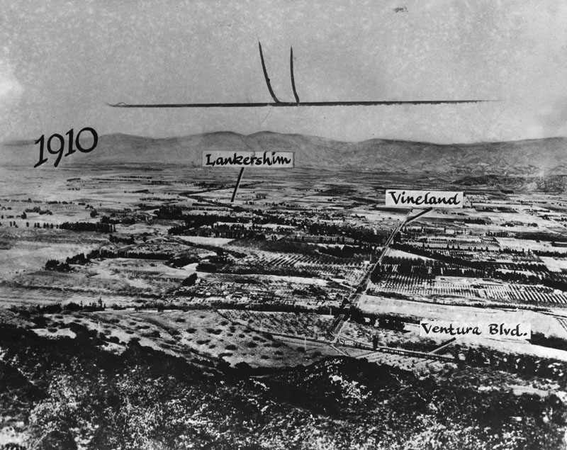
| (1910)* - View looking north across the San Fernando Valley. Vast amounts of farmland can be seen throughout. |
 |
|
| (1910)* - Road on top left is Lankershim. Road that comes straight down on the right is Vineland, which curves into Ventura Boulevard (same as previous photo except for street names being highlighted). |
| (ca. 1910)^ - Milk delivery by dog cart, probably around 1910. This was taken at the intersection of Ventura Blvd. and Lankershim Blvd. The milkman is pouring milk into a pitcher. |
 |
|
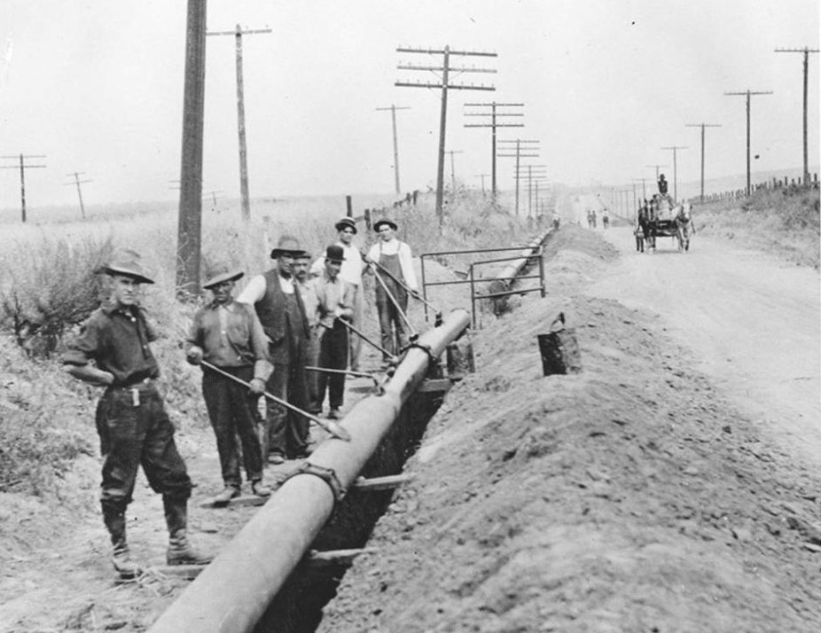
| (1910)^ - Workers putting in a new gas line along San Fernando Road. |
Historical Notes The San Fernando Rd. gas line was completed in 1912 and by 1913, gas was transported to Burbank from the natural gas fields in Taft, CA. Gas services would reach Tujunga by 1924. |
* * * * * |
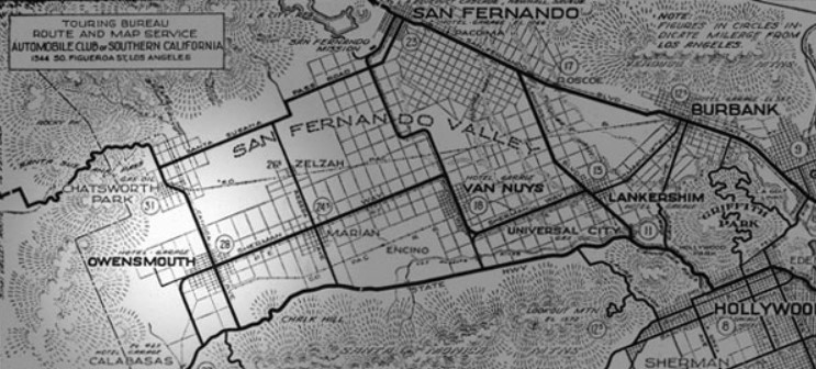
Lankershim Development Co. and Los Angeles Suburban Homes Co. (aka The Syndicate)
| (ca. 1910)^ – Postcard showing early development in the San Fernando Valley. The map is marked to identify the routing of a new Red Line that would run from Hollywood through Cahuenga Pass and then to the towns of Lankershim (North Hollywood) and Van Nuys. The Lankershim Development Company was located in downtown LA and developed the towns of Lankershim (North Hollywood) and Van Nuys. |
Historical Notes As the City of Los Angeles authorized building 'William Mulholland's' Los Angeles Aqueduct from the Owens Valley to the city and valley, land speculation plans for the Los Angeles Farming and Milling Company property in the San Fernando Valley were developed. Construction began in 1905. Dryland farming could now be turned into crops, orchards and residential towns. In the "biggest land transaction ever recorded in Los Angeles County", a syndicate led by Harry Chandler, business manager of the Los Angeles Times, with Isaac Van Nuys, Hobart Johnstone Whitley, and James B. Lankershim acquired "Tract 1000", the remaining 47,500 acres of the southern half of the former Mission lands—everything west of the Lankershim town limits and south of the old furrow (present day Roscoe Boulevard) excluding Rancho Los Encinos and Rancho El Escorpión. As the Los Angeles Suburban Homes company, they laid out plans for the towns of Van Nuys, Marian (now Reseda) and Owensmouth (now Canoga Park and West Hills), a system of highways, and incorporation by the city of Los Angeles to get the Owens River water. In the "Sale of the Century" in November 1910 they sold the remaining livestock and non-land assets of the Lankershim Farming and Milling Company at auction. The Los Angeles Times called the auction "the beginning of a new empire and a new era in the Southland". On February 22, 1911, lot sales begin at the new town of Van Nuys, California. |
Sherman Way - "The $500,000 Boulevard"
 |
|
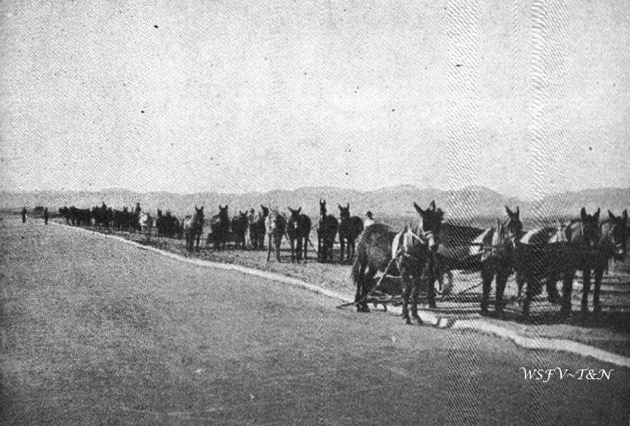
| (1910)* - View showing the construction of Sherman Way, the $500,000 Boulevard, with the assistance of teams of mules. |
Historical Notes In 1910, the board of the Los Angeles Suburban Homes Company sat down to discuss the land they had bought the previous year. One of the subjects was roads. The existing roads were bumpy and Isaac Van Nuys refused to let the new owners strew the roads with straw to keep the dust down, due to his fear of fires destroying crops. The Board felt it was important to build a good oiled road for general traffic, all through their land and up to the Workman Station (Owensmouth area), for the purpose of showing the land they would be selling. Two names were voted on for this road: Auto Speedway and Sherman Way. Sherman Way won the vote (only Whitley voted for the other), named for General Moses Hazeltine Sherman , one of the five board members. To H.J. Whitley, who wanted to be known as “The Great Developer,” palm trees were a necessary adornment. He had them planted in 1911 along the twenty-two miles of Sherman Way that traversed the length of the San Fernando Valley. The boulevard’s broad sweep was patterned after the Paseo de la Reforma in Mexico City and served as a sales enticement, much like the fountain-punctuated, artificial lakes of modern desert developments. |
* * * * * |
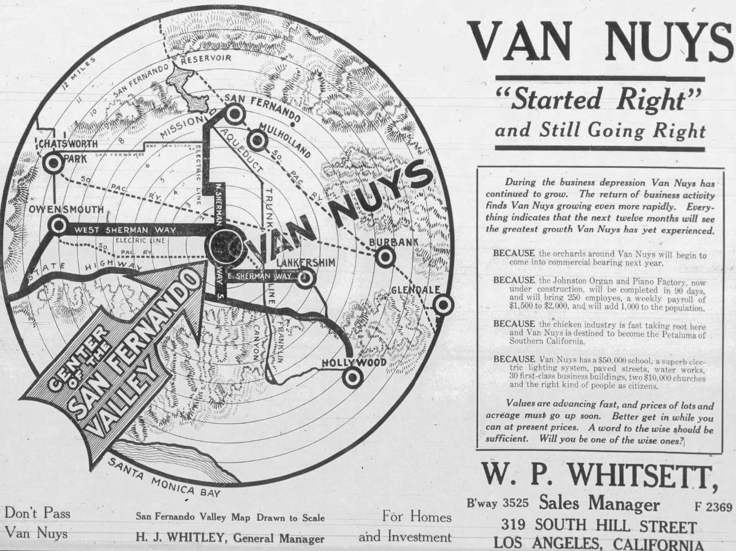
Van Nuys - "The Town That Started Right"
.jpg) |
|
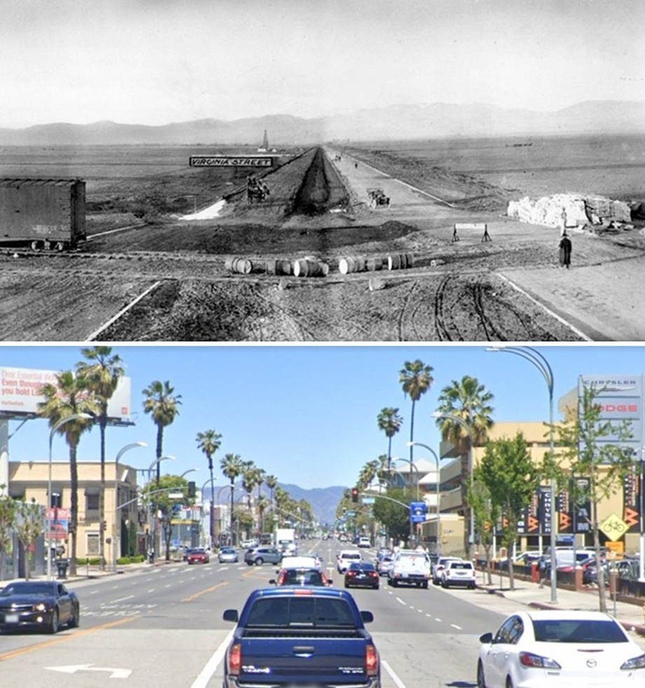
| (1911)* - Site of the future Van Nuys in 1911 looking north, showing work being done on Van Nuys Boulevard. Virginia Street (later Sylvan Ave.) is marked, behind which is an oil derrick. Tracks and a railcar are seen in the foreground. |
Historical Notes In 1910, developers Moses Hazeltine Sherman, Harry Chandler, H. J. Whitley, and others formed the Los Angeles Suburban Homes Company and purchased nearly 48,000 acres of the old Van Nuys and Lankershim ranch lands. Their plan was to create a series of modern towns throughout the San Fernando Valley—Van Nuys, Marion (now Reseda), and Owensmouth (now Canoga Park). The location was chosen with care: flat, fertile land, near the path of the coming Owens River Aqueduct, and close enough to Los Angeles to be reached by rail. The first major improvement was grading and paving what would become Van Nuys Boulevard, shown here under construction. The Pacific Electric Railway’s tracks were laid down the center of the street to connect the Valley with downtown Los Angeles. The oil derrick in the background reminds us that the Valley was still a mix of farms, ranches, and oil leases before the suburban transformation began. |
.jpg) |
|
| (1911)* - Right panel view showing the railroad tracks crossing Van Nuys Boulevard. A partial view of the train depot is seen on the right. Note the vast expanse of open land toward the northeast. |
Historical Notes The railroad seen here was part of the Pacific Electric system—often called the “Red Cars.” The company built an extension into the San Fernando Valley in 1911–1913, making Van Nuys one of the first fully planned “streetcar suburbs” in Los Angeles history. The new line through Cahuenga Pass was completed in December 1911, and full service from downtown Los Angeles to Van Nuys began in March 1913. The depot visible on the right served both freight and passengers, and it became a lifeline for the early community. Farmers shipped crops to city markets, and home buyers rode the Red Cars out to view and purchase land. This integration of transportation, water, and real estate was deliberate—the developers believed that good planning and reliable infrastructure would attract permanent residents, not just speculators. The wide open fields in the distance would soon fill with homes, businesses, and orchards, following the arrival of city water in 1913 and the annexation of the area to Los Angeles in 1915. |
 |
|
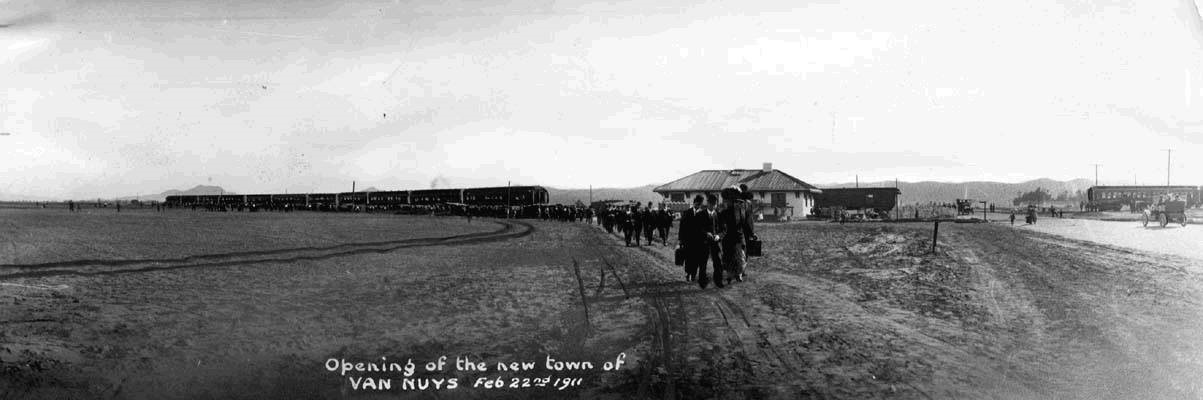
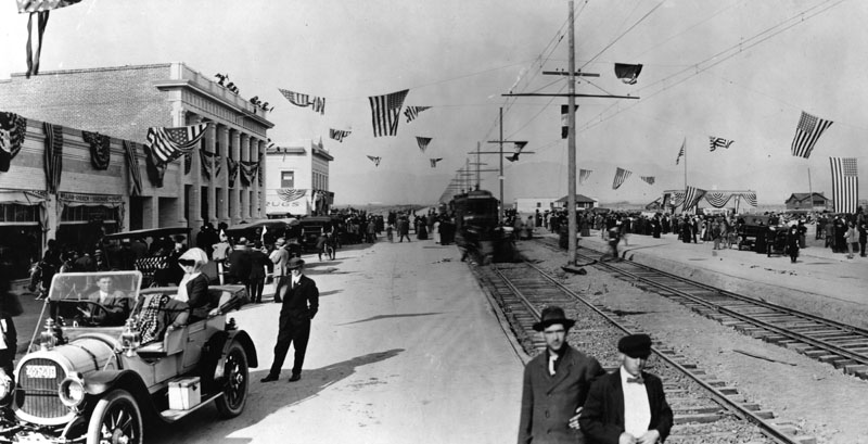
| (1911)* - "Opening of the new town of Van Nuys" - February 22, 1911. This panoramic view shows a long procession of people walking away from the train depot toward the camera, some carrying luggage. A train unloading passengers is seen in the background. On the right, an early model car is seen heading toward a second train. |
Historical Notes On February 22, 1911—George Washington’s Birthday—the developers staged a grand opening for the new town of Van Nuys. Excursion trains carried hundreds of prospective buyers and guests from Los Angeles to the brand-new depot, where they were greeted with flags, music, and a huge barbecue lunch. The event marked the official start of lot sales and the founding of Van Nuys. The Los Angeles Suburban Homes Company advertised the Valley as the “Garden Spot of the World,” promising a new life where clean air, sunshine, and cheap land could turn settlers into prosperous farmers and homeowners. The presence of automobiles, trains, and large crowds in this photo captured the spirit of optimism and progress that defined early twentieth-century Los Angeles. The opening day was a complete success. Nearly every lot offered was sold, and within a year Van Nuys had stores, schools, a bank, and growing neighborhoods. |
Then and Now
 |
|
| (1911 vs. 2021)* - View looking North on Van Nuys Boulevard from near Delano Street. Virginia Street (seen in above photo) later became Sylvan Street. Photo comparison by Jack Feldman. |
Historical Notes The first photograph shows Van Nuys Boulevard as a wide dirt roadway being graded in 1911, with only survey stakes and rail tracks hinting at the future city. The 2021 view shows a busy commercial corridor filled with cars, shops, and offices—a striking reminder of how quickly the San Fernando Valley changed once water, transportation, and opportunity came together. From its earliest days, Van Nuys was designed to be the civic and commercial heart of the Valley. The careful layout, transportation planning, and marketing success in 1911 truly made it, as the slogan promised, “The Town That Started Right.” |
 |
|
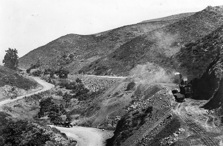
| (1911)* - Tracks are being built through the hills of the Cahuenga Pass as shown on the right side of this picture. On the lower road can be seen supplies coming and going by teams of horses and wagons |
Historical Notes In 1911, General Sherman (as he was called) added an extraordinary streetcar line. Built over Cahuenga Pass, through North Hollywood to the 1911 town site of Van Nuys, and on to the 1912 town site Owensmouth, now Canoga Park. Wilson C. Weddington, an early Valley pioneer who founded the Weddington Bros. General store, was also instrumental in bringing the Red Car to the Valley. |
 |
|
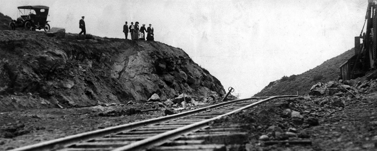
| (1911)* - LA Times photo showing sightseers checking out the new Pacific Electric trolley line being built in the Cahuenga Pass between Hollywood and the San Fernando Valley. |
Historical Notes The original April 9, 1911, Los Angeles Times caption reported: Electric Line to Van Nuys Through Cahuenga Pass. This picture shows the railroad as now laid to the highest point in the gap which unites Hollywood with the rich San Fernando Valley. The road will be in operation early in the summer. Express trains connecting the town of Van Nuys with Los Angeles will make only one stop, Hollywood. |
 |
|
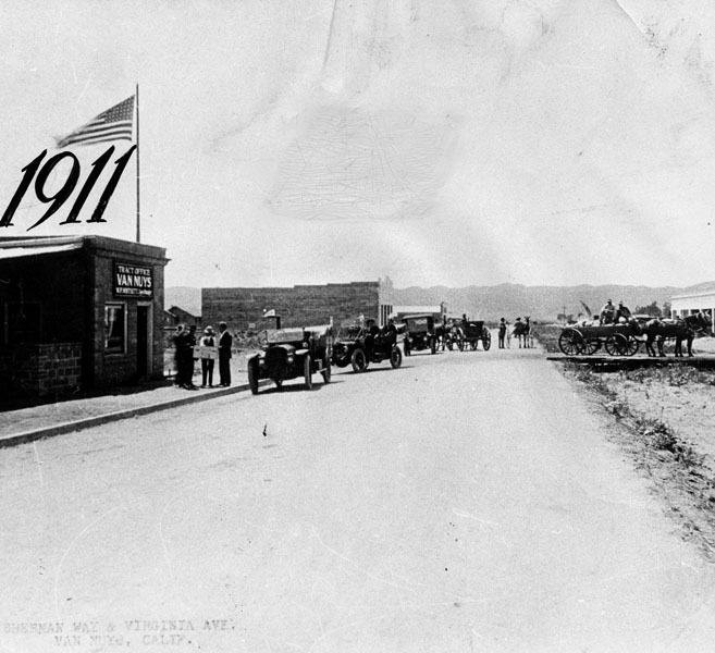
| (1911)* - Downtown Van Nuys shortly after the community was started. On left is W.P. Whitsett's tract office for selling land on the corner of what is now Van Nuys Blvd. and Sylvan Street. |
Historical Notes Van Nuys Boulevard was then called Sherman Way and Sylvan Street was known as Virginia Street. |
 |
|
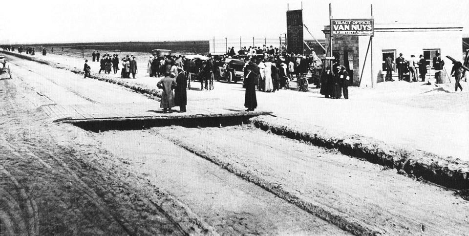
| (1911)* – View showing prospective customers congregating around the Van Nuys tract office. Sign reads: ‘ Tract Office – Van Nuys – W.P. Whitsett. Note the wooden crossing over a trench seen in the foreground. This is the center of Van Nuys Boulevard (at the time known as Sherman Way). The trench is where streetcar rails would be layed. |
 |
|
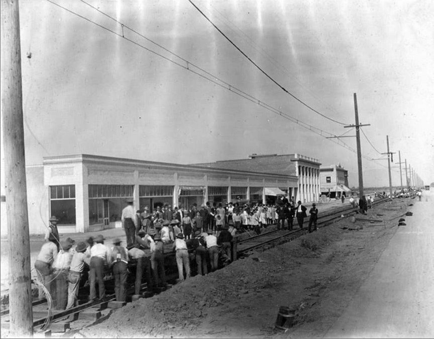
| (1911)^^#^ - Workers laying the rails for the Pacific Electric Line in Van Nuys. |
Historical Notes The streetcar line in the so-called “Town That Started Right” ran 19 miles from Los Angeles along Chandler Boulevard from Lankershim (now North Hollywood), turning up Van Nuys Boulevard to Sherman Way. |
 |
|
| (ca. 1911)#^# – Postcard view showing Van Nuys Boulevard shortly after the installation of Pacific Electric streetcar tracks. |
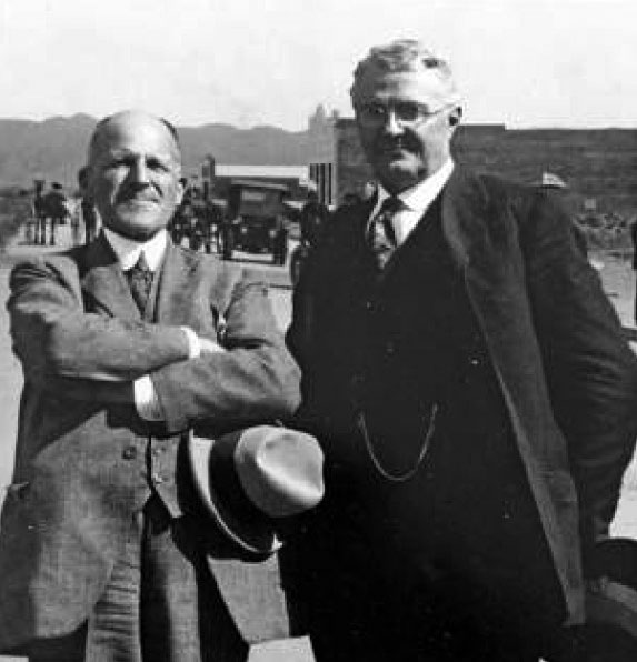 |
(ca. 1911)### - Moses H. Sherman (L) and Harry Chandler (R) standing on Van Nuys Boulevard at the heart of their new land development. |
|
Historical Notes Moses Sherman and Harry Chandler (along with Gen. H. G. Otis, H. J. Whitley, and Otto F. Brant) were two of the five original investors in the Suburban Home Company (aka The Syndicate). Each of the major partners put up $100,000. |
 |
|
| (1911)* - People stand by their parked cars in anticipation of the arrival of the Valley's first Pacific Electric streetcar. A train is seen in the background of an unpaved road. |
Historical Notes Along with the streetcar line, Moses Sherman also built the "$500,000 boulevard" named Sherman Way next to the tracks all of which were the key to the development of the Valley. By 1912, 45 minute streetcar service from Van Nuys to downtown and the "no speed limit" paved road (if you could get your "Model A" to do 30 mph) were key selling points. |
 |
|
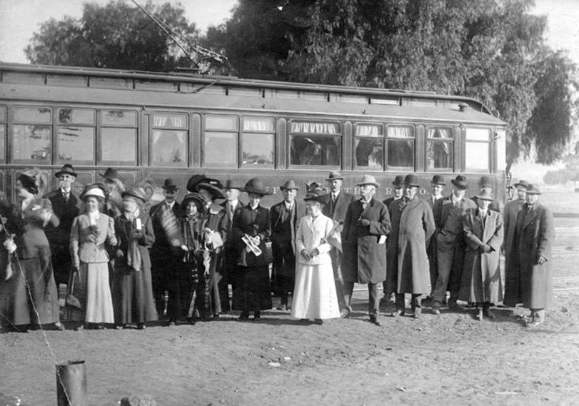
| (1911)* - View of a group of well-dressed people standing in front of the first "Red Car" to arrive in Lankershim (North Hollywood). The streetcar then continued on its journey to Van Nuys. |
.jpg) |
|
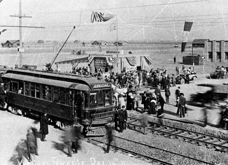
| (1911)#** - View showing the ceremony for the arrival of the first Pacific Electric "Red Car" in Van Nuys. Note the photographer with tripod-mounted camera at lower right. |
Historical Notes The Hollywood-Van Nuys Extension was completed in December, 1911, and the first car entered Van Nuys on December 16, 1911. |
 |
|
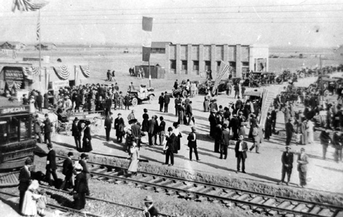
| (1911)* - View showing a crowd of people in Van Nuys at the arrival of the first Pacific Electric "Red Car." American flags are draped over buildings and on lines that run over the tracks. |
 |
|
| (1911)#^ - View showing hundreds of people at the arrival of the first Pacific Electric Car in Van Nuys. The Van Nuys Tract office, visible behind the train, is open for business. |
Historical Notes The day was a time of rejoicing and the Valley was connected to the City in a way which was to see its grain fields cut up into building lots and homes. |
 |
|
| (1911)* - Crowds of people surround the first streetcar to arrive in Van Nuys on December 16, 1911. |
Historical Notes From North Hollywood to Kester Junction, a distance of 2.26 miles, this line originally shared the right-of-way and finally the rails of Southern Pacific’s North Hollywood Branch. |
 |
|
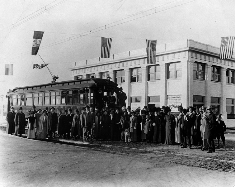
| (1911)* - View showing a group of people posing in front of the Van Nuys' first streetcar with flags flying overhead. |
Historical Notes After completion of the Hollywood-Van Nuys Extension, construction crews were immediately shifted to the two branches: Owensmouth and San Fernando. The Van Nuys-Owensmouth Extension was begun in January 1912, and final work was completed in July 1913. It was possible to operate cars thorough to Owensmouth considerably earlier, however; Owensmouth welcomed its first big red car on December 7, 1912. The Van Nuys-San Fernando Extension got under way in January 1912, also. It was completed in March 1913, with the first car rolling into San Fernando on March 22, 1913. |
 |
|
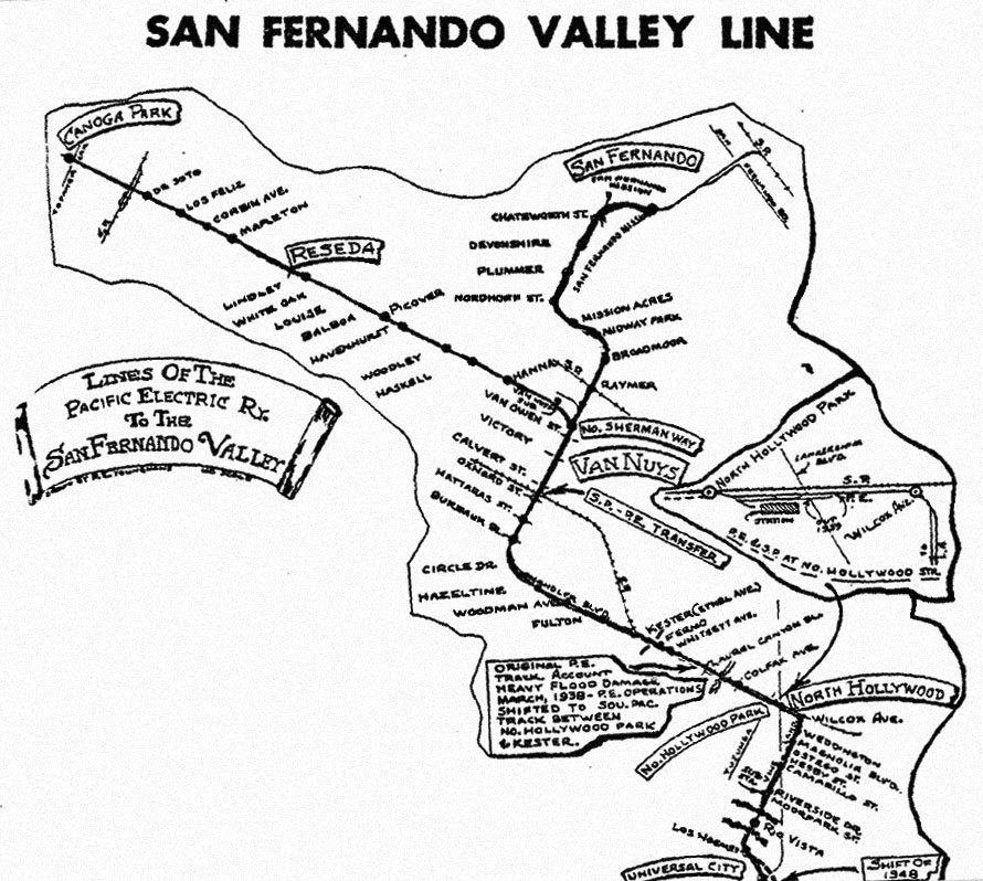
| (1911 - 1952)***^^ - Map showing the Lines of the Pacific Electric Ry. in the San Fernando Valley. |
Historical Notes The San Fernando Valley line followed the Santa Monica Boulevard line as far as the intersection of Santa Monica and Highland Avenue (7.12 miles). There it turned north on Highland Avenue, using the tracks of the Highland Avenue line to the mouth of Cahuenga Pass (MP 8.66) where its own trackage commenced. This line originally negotiated Cahuenga Pass via a double track line located to the east of the highway. Construction was quite difficult and its successful completion was regarded at the time as being somewhat of a triumph for the Los Angeles Pacific construction crews. Once through the pass, the line passed Universal City (11.11 miles) and arrived at Lankershim (North Hollywood) where the double track ended, 13.83 miles from the Subway Terminal in Downtown Los Angeles. From Kester Junction this line proceeded on its own single track to the town of Van Nuys, passing through the town on double track to North Sherman Way, 19.93 miles, where the line branched into two lines. One branch turned west on Sherman Way, arriving at Reseda, 24.91 miles, and finally at its terminus, Owensmouth (Canoga Park), 29.10 miles. This was single track except for short portions of double track through the two towns. The other branch continued north from Sherman Way via Mission Acres (MP 22.81), Plummer (MP 23.81) and the San Fernando Mission to the city of San Fernando (MP 27.47). This also was single track save for about three blocks of double track operation in the city of San Fernando. Operation through to Owensmouth and San Fernando was terminated on June 1, 1938; thereafter the terminus of this line was at Van Nuys Boulevard and North Sherman Way. On December 28, 1952, busses over the Hollywood Freeway replaced all rail service on this line. |
 |
|
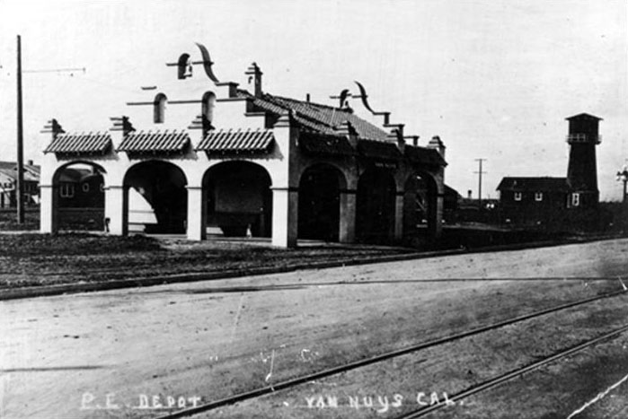
| (1914)* – View showing the Van Nuys Pacific Electric Station. To the right is the Van Nuys Water Company's pump house and water tower. |
Historical Notes The new LA-Valley streetcar system was so successful that by 1913, over 368,000 passengers rode the line, and by 1926 that number topped one million. |
 |
|
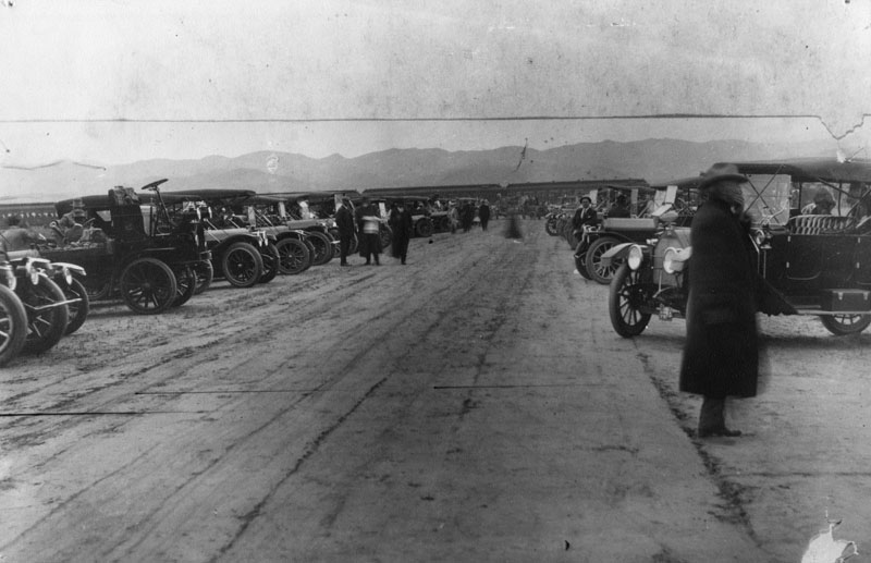
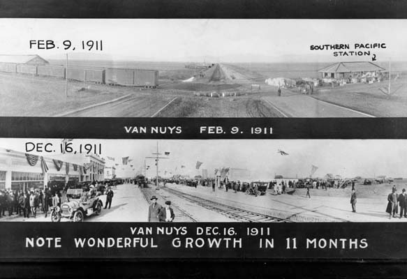
| (1911)*^ - A sample of the growth boom in Van Nuys, February-December, 1911. |
Historical Notes The sprawling San Fernando Valley was a vast field of grain when the Los Angeles Pacific (LAP) began building north through the Cahuenga Pass from Hollywood in 1911. During the course of construction the LAP was merged with the Pacific Electric (PE). By the time of its completion the line was PE. |
 |
|
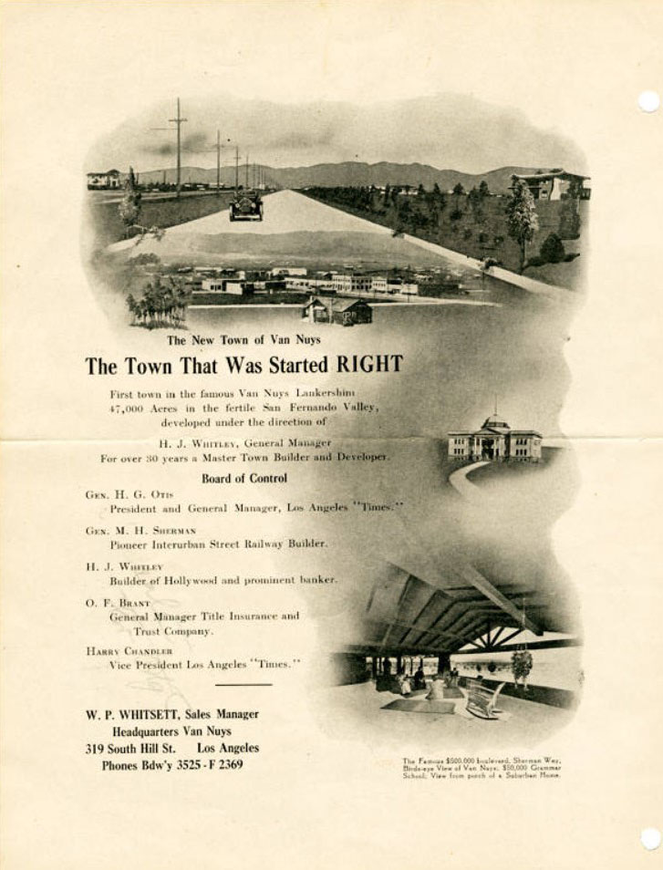
| (ca. 1912)#^ - Brochure for W. P. Whitsett's free automobile tour to Van Nuys. |
Historical Notes Above is the inside of a 2-sided brochure that was handed out to prospective buyers during their free automobile tour of Van Nuys. It was a promotion developed and coordinated by W. P. Whitsett. The brochure also identifies the 'Control Board' members of the Los Angeles Suburban Homes Company: Gen. H. G. Otis, Gen. M. H. Sherman, H. J. Whitley, O. F. Brant, and Harry Chandler. It also identifies W. P. Whitsett as the Sales Manager. |
 |
|
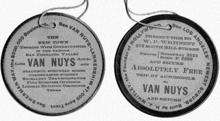
| (ca. 1912)#^ - Tag advertising a free trip by automobile from downtown Los Angeles to the San Fernando Valley. |
Historical Notes Whitsett began to develop Van Nuys as early as 1910. To promote his development, he passed out coupons in the form of tags that offered a free tour of Van Nuys by automobile. |
 |
|
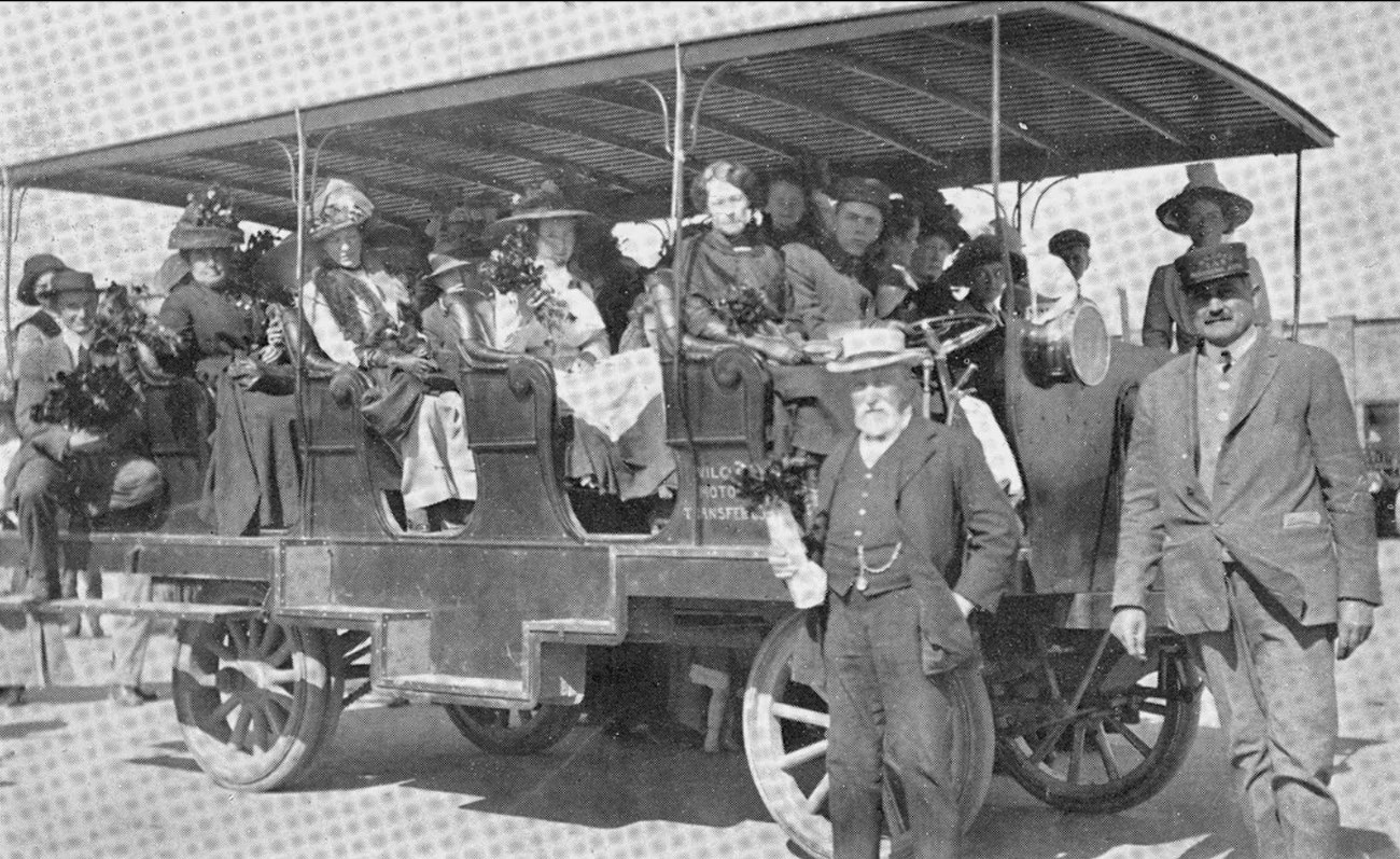
| (1911)* - Early motor coach used to bring prospective buyers to Van Nuys. Sign on the side of vehicle reads Wilcox Motor Transfer. |
 |
|
| (1912)* - Opening of the first tract office in Van Nuys at North Sherman Way (later Van Nuys Boulevard) and Virginia Street (later Sylvan Street) in 1912, with two carfulls of eager salesmen waiting. W.P. Whitsett was the sales manager of the office. Lots started at $350. |
Historical Notes W. P. Whitsett was extremely successful in bringing prospective land and home buyers into the Valley. Whitsett Avenue was named after William P. Whitsett who is remembered by some as the "Father of Van Nuys." He was also a major land developer and water official in Los Angeles. The street was first known as Encino Avenue.^* Click HERE to see more SFV Street Name Origins. |
 |
|
| (1913)* - Van Nuys 'Started Right' and Still Going Right". Courtesy of The Van Nuys News and Valley Green Sheet, Fri, Sep 05, 1913. |
 |
|
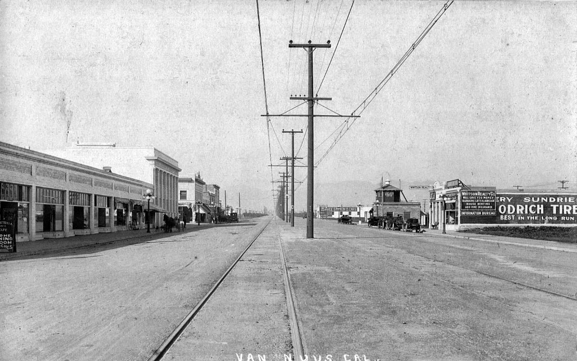
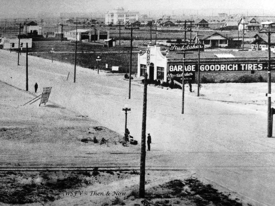
| (1914)#^*^ - View of Van Nuys, looking NE along North Sherman Way, later renamed Van Nuys Blvd. The tall three-story building in the distance is Van Nuys Grammar School (built in 1912). Signs on large building at center-right reads: Studebaker - GARAGE - GOODRICH TIRES |
 |
|
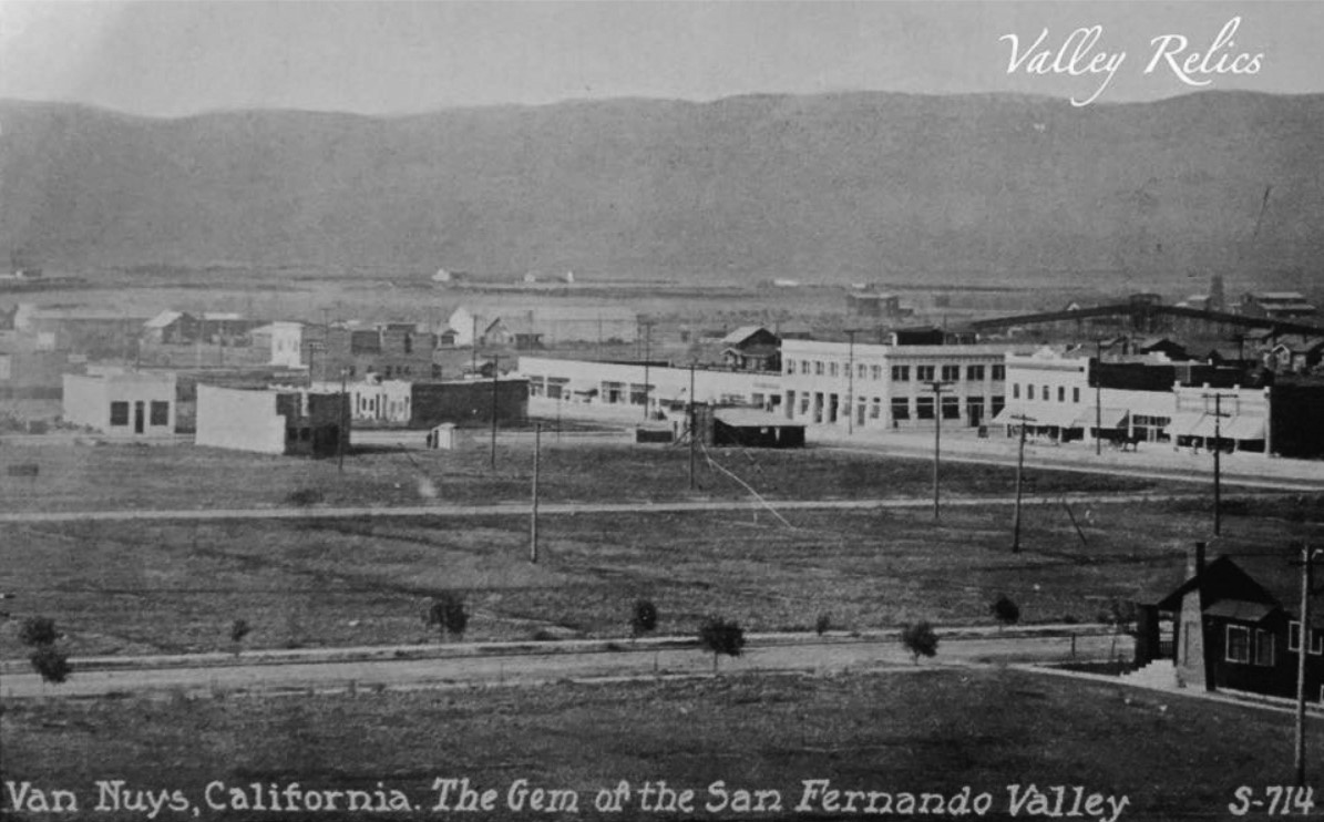
| (ca. 1912)* – View looking southwest showing the commercial center of Van Nuys, California. “The Gem of the San Fernando Valley” |
 |
|
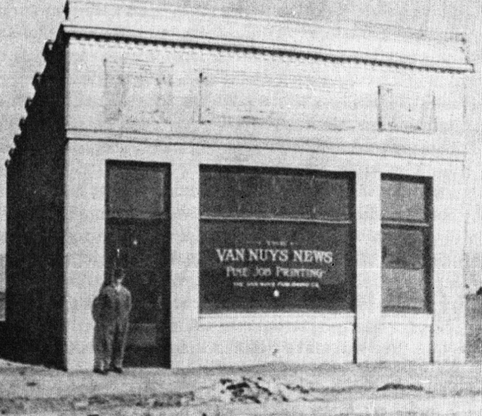
| (ca. 1911)* – View showing Frank M. Keffer standing in front of the Van Nuys News building located at 14441 Sylvan Street. |
Historical Notes The paper, founded by E.R. Elkins, debuted as The Van Nuys Call on Nov 3, 1911, just nine months following the birth of the town. Purchased by Frank Keefer, a reporter from Pittsburgh, it was published as The Van Nuys News on Nov 24, 1911. The first building was at 14441 Sylvan Street (seen above). It was published as a 4-6 page weekly for a number of years. Walter Mendenhall joined as co-publisher in 1920, and in June of 1922, the paper went semi-weekly. Keffer retired in 1932, and joining Mendenhall as co-owners were brothers Maurice W and Ralph J Markham. In September of 1936, the News moved into its new home at 14539 Sylvan Street. Wanting to reinforce its reputation as the Valley Paper, in the 1940’s it became the Van Nuys News and Valley Green Sheet, when the front page was printed on a pale-green broadsheet to distinguish it from its competitors, in the early 1950’s becoming the Valley News and Green Sheet, and expanded its reach, eventually into the Conejo, Simi and Santa Clarita Valleys. Frequency increased to tri-weekly in October, 1954, and then to four-times-a-week in 1959. New branch offices began to appear in North Hollywood, Canoga Park and Thousand Oaks. The Tribune Company, headquartered in Chicago, acquired the news in December of 1973. In 1976, it became a daily newspaper, and in 1981 changed its name to the Daily News. Subsequently, ownership of the newspaper has changed several times since. |
 |
|
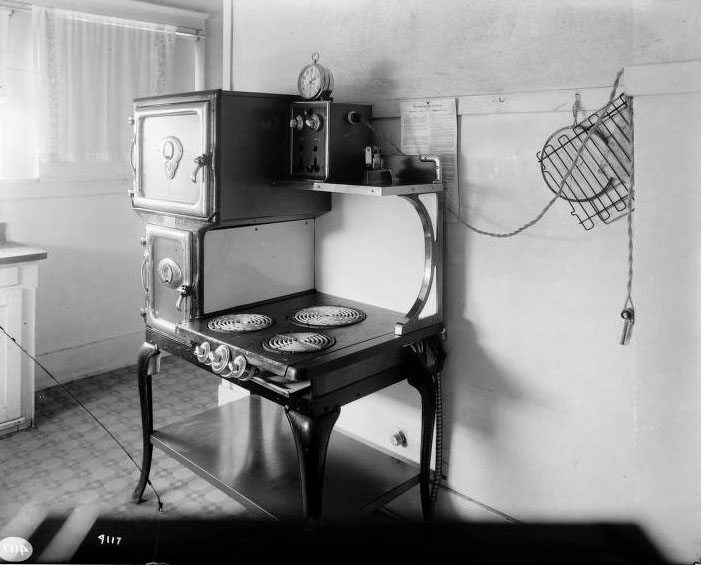
| (ca. 1917)*^^^ - Westinghouse Electric range (with iron in upper corner and an electric timing device) at a home in Van Nuys. |
Historical Notes In 1917, Westinghouse introduced its first all-electric kitchen range. It advertised its new ranges as follows: These are full size cooking ranges for domestic use, and have reached their high perfection in convenience and economy through many years of experimenting and experience. In addition to the cleanliness, safety, saving in food, and general desirability of cooking with electricity, they have the further advantage of saving a great deal of care, trouble and expense by the aid of the Westinghouse exclusive economical features of full automatic control by attached clock and thermostats. By 1917, most of the valley was already annexed into the City of Los Angeles. Not only was there enough water for the Valley, but there was also more than enough electricity to serve a growing city. Click HERE to see more in Electricity on the Aqueduct. |
Van Nuys High School
 |
|
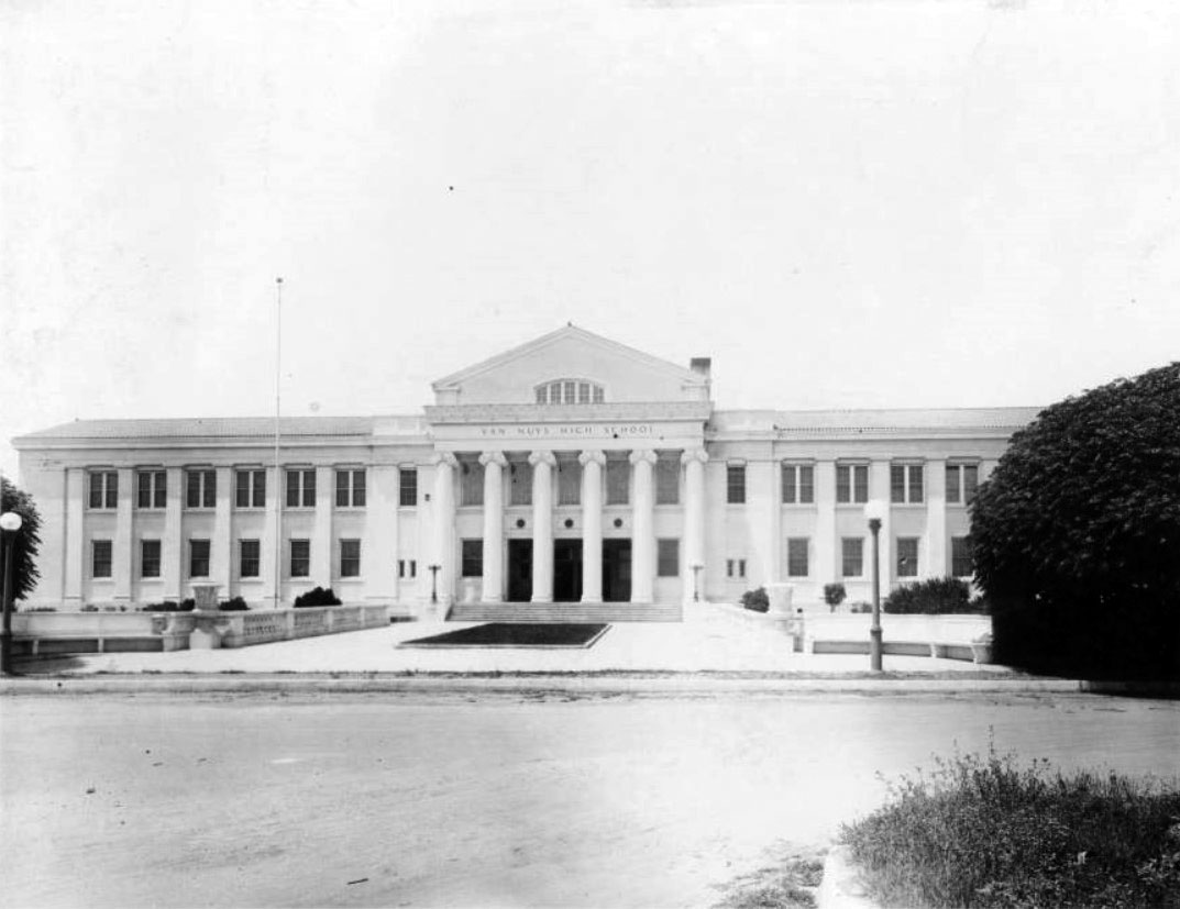
| (n.d.)^^ – Front view of Van Nuys High School showing the impressive Ionian columns framing the main entrance, located at 6535 Cedros Avenue at Haynes Street. |
Historical Notes Van Nuys High School opened in 1914, four years after Van Nuys was established. For years, the only high schools in the Valley were Van Nuys, Owensmouth (now Canoga Park), San Fernando, and North Hollywood. The football and track stadium, originally built at the same time as the current high school, is named for Bob Waterfield, and the baseball field for Don Drysdale, the two most famous athletes to have played for VNHS.*^ |
 |
|
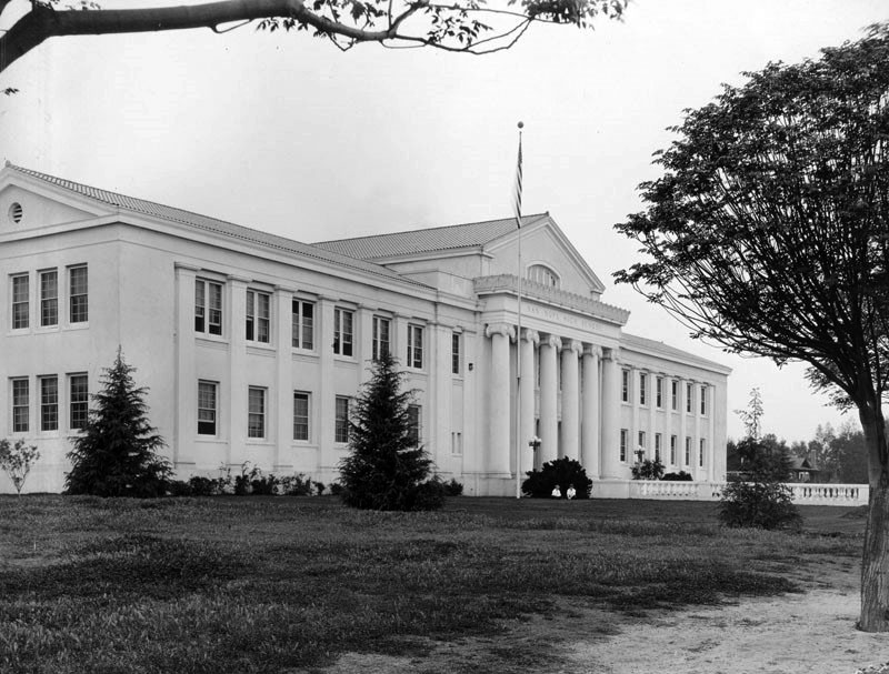
| (ca. 1923)#** – Early view of Van Nuys High School with its Classic Greek-style architecture. |
Historical Notes Marilyn Monroe attended Van Nuys High School. Click HERE to see more Notable Alumni. |
Van Nuys Hotel
 |
|
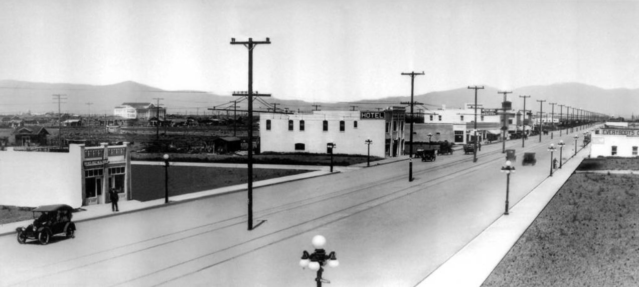
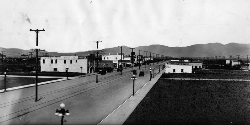
| (1913)^ – Panoramic view looking north showing early development along Sherman Way (later Van Nuys Boulevard). Two sets of tracks and an electrical pole line run down the center of the street. All of these buildings have been torn down and replaced except for the Van Nuys Hotel building (6211 Van Nuys Blvd), visible here with the "Hotel" sign on it. At left-center can be seen the newly constructed Van Nuys High School located at 6535 Cedros Avenue. Note the ornate 5-bulb streetlights along both sides of Van Nuys Boulevard. |
 |
|
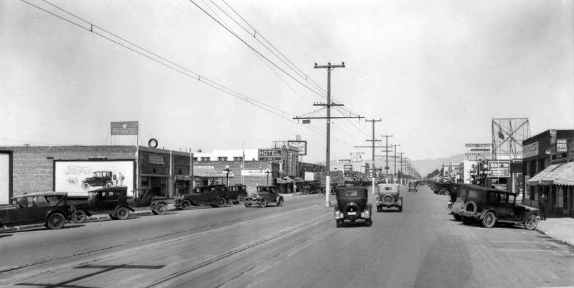
| (1926)^^ - Wide-angle view looking north on Van Nuys Boulevard showing the Van Nuys Hotel on the west side of the street (left-center). The hotel is located near the NW corner of Van Nuys Blvd. and Delano St. Note the power lines and streetcar tracks running down the center of the wide street. |
 |
|
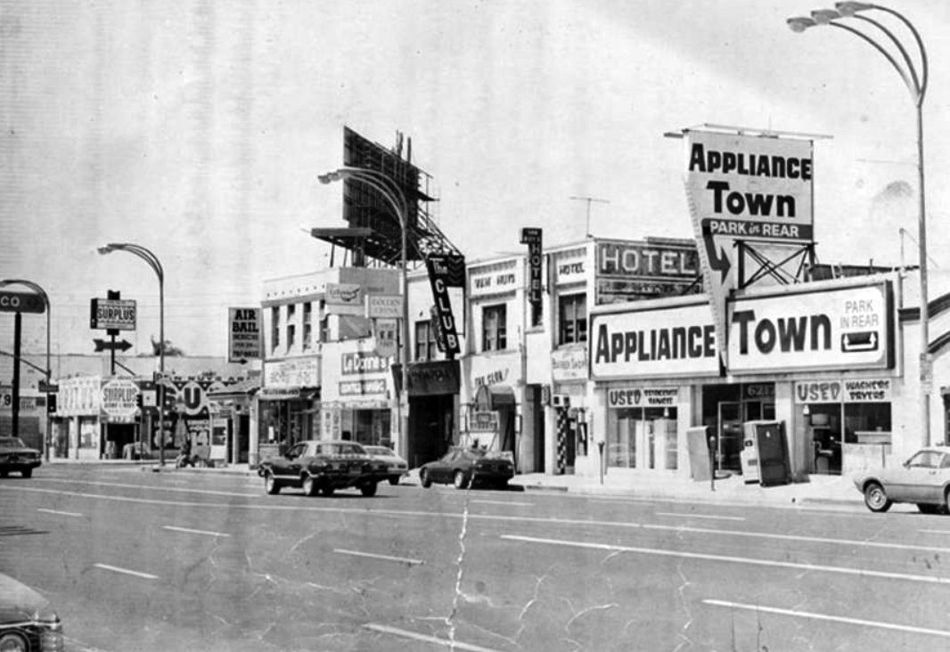
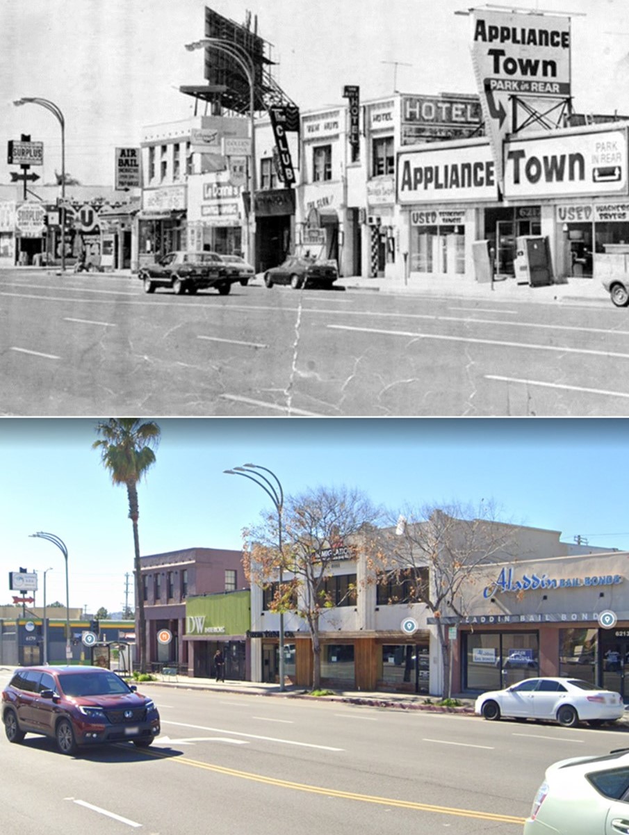
| (1970s)^ - View looking SW on Van Nuys Boulevard toward Delano Street. Visible at center is 6211 Van Nuys Boulevard, known at that time as the Van Nuys Hotel. It is believed to have had such boarders as silent film star William S. Hart. *Note the forked three-arm streetlights. At the time of their installation they were the brightest streetlights in Los Anglees. |
Historical Notes The forked three-arm streetlights seen above were chosen in the early 1970's by representatives of the Van Nuys business community to light Van Nuys Boulevard and Magnolia Boulevard. Originally, 1,000 watt mercury vapor lamps were used to provide on average five foot-candles. This turned out to be too bright and too costly from an energy level. Today, these three-pronged electroliers can still can be seen on and around Van Nuys Boulevard. However, the luminaires today are 250 watt high-pressure sodium. Click HERE to see more. |
 |
|
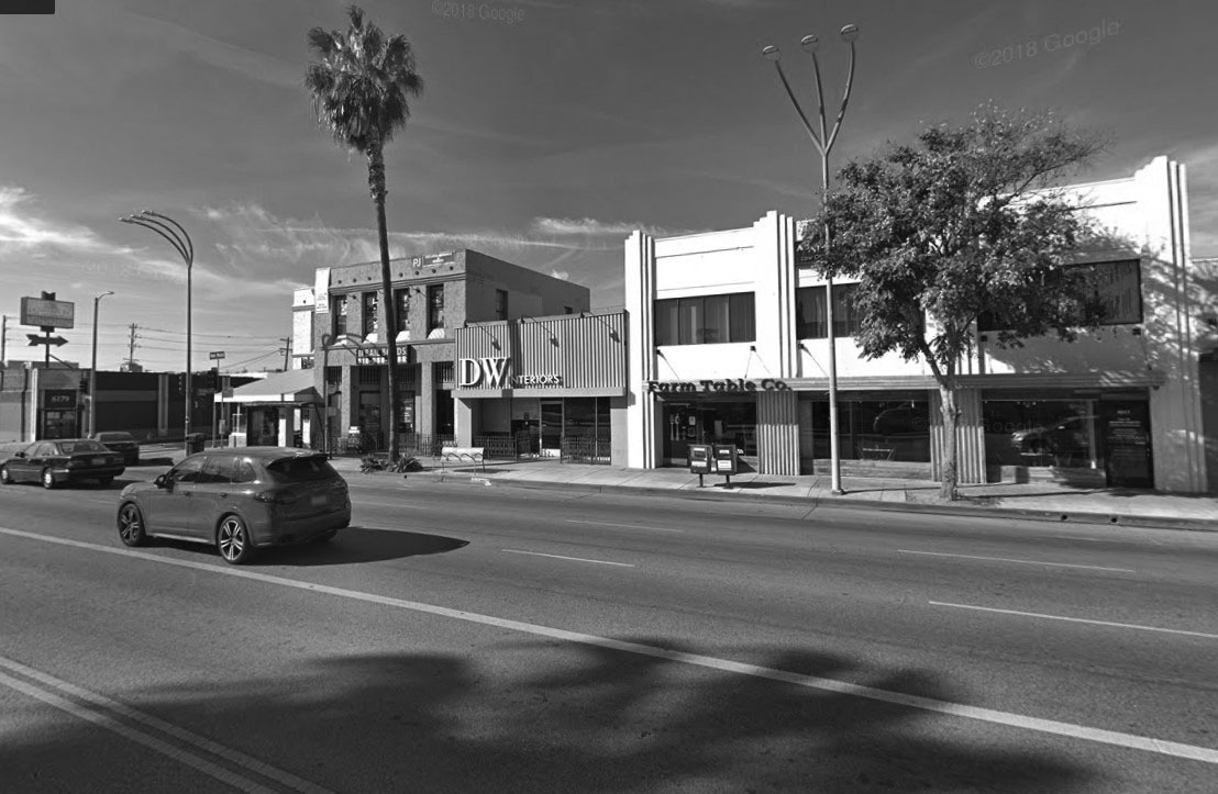
| (2018)^^ – View showing the old Van Nuys Hotel building at 6211 Van Nuys Boulevard. Expanded and modified, the building is now occuppied by Bail Bonds office and Mexican restaurant. Click HERE for a closer view. |
Then and Now
 |
|
| (1970s vs. 2023)* - Looking SW on Van Nuys Boulevard toward Delano Street. |
* * * * * |
Early SFV Streetlights
 |
|
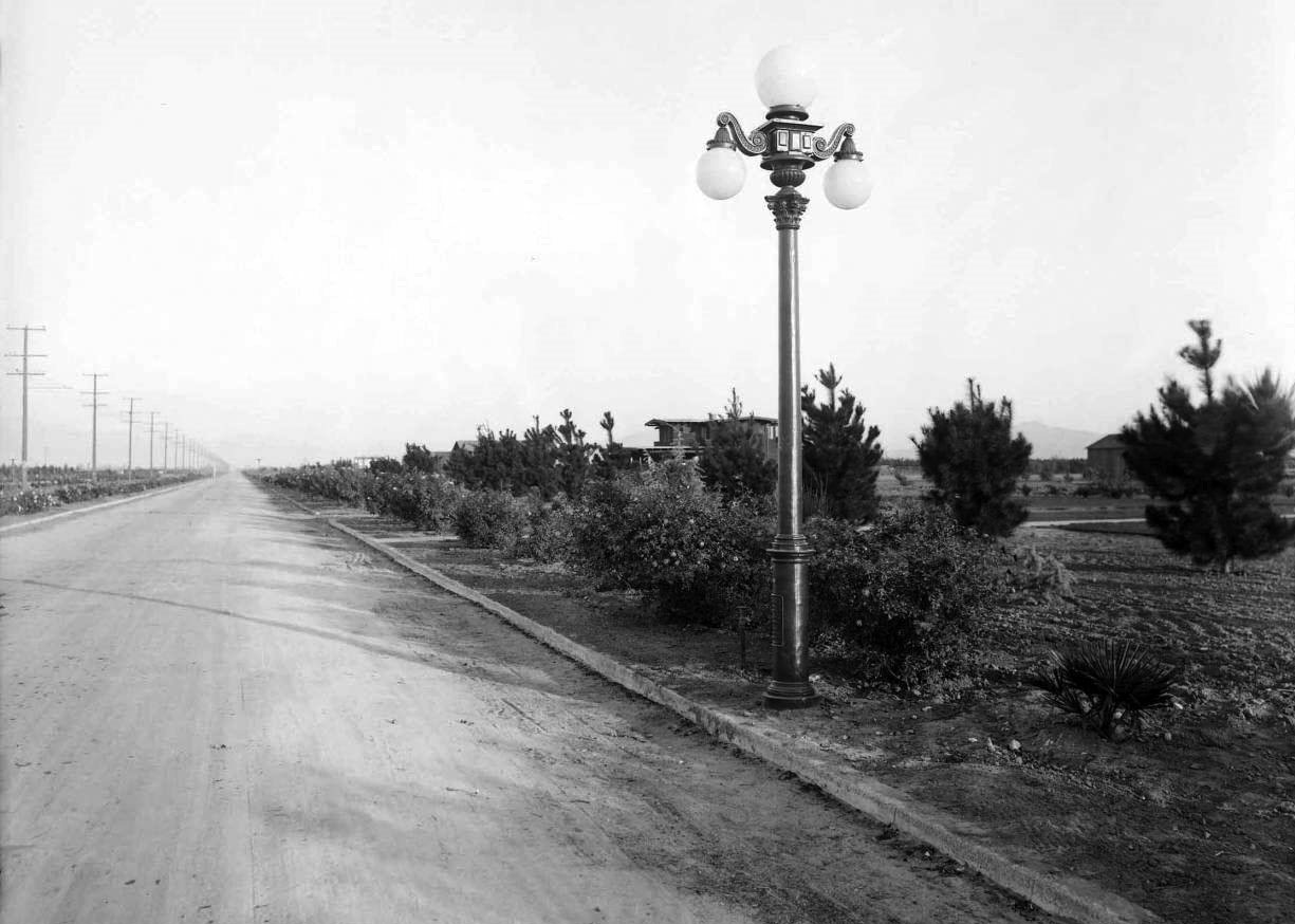
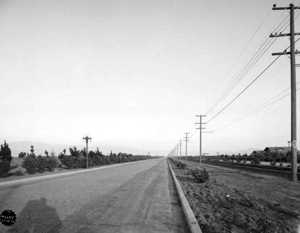
| (ca. 1912)* - Early view of Van Nuys Boulevard, looking north. Note the ornate 5-lamp light posts along the sidewalks. These lamps were also installed in front of most of the old mansions in Downtown LA. |
Historical Notes The Van Nuys Highway Lighting District was organized August 10, 1912, under the California act providing for the highway lighting of unincorporated towns and villages and country sections. The Van Nuys District, which is 16 miles long and 8 miles wide, embraces about 52,000 acres in the southwestern part of the San Fernando Valley (at the time). The votes creating the district came from the new settlers. Sixty votes were recorded for and eighteen against. The small vote was due to the fact that the majority of people living in the tract came from other states and were not eligible to vote on account of not having been in California the required year. The first lighting undertaken by the district was along Sherman Way, the 16 mile boulevard extending thru the tract. A sum of $75,000 was recommended for this purpose, which was included in the 1912 taxes of the district, and the entire amount was raised in that year.* |
 |
|
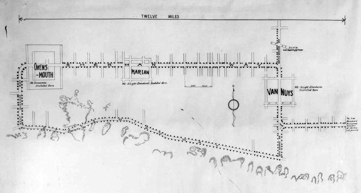
| (1913)^.^ - Map showing the proposed streetlights for the Van Nuys/Marian/Owensmouth Lighting District. Photo courtesy of Dean Fields. |
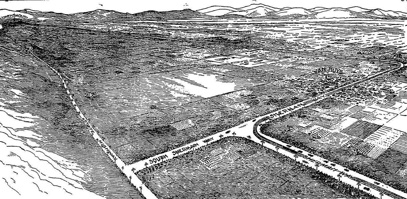
Historical Notes This was the first Lighting District the County of Los Angeles created. When completed the lighting system had 484 three-light posts (electroliers) and 129 five-light posts (electroliers). Streetlight "Electroliers" are defined as free-standing streetlights generally on their own posts. The above map shows the original route of Sherman Way, which today is west on Chandler, north on Van Nuys Blvd, and west on Sherman Way. The other sections of today's Van Nuys Blvd were known as South Sherman Way and North Sherman Way. |
 |
|
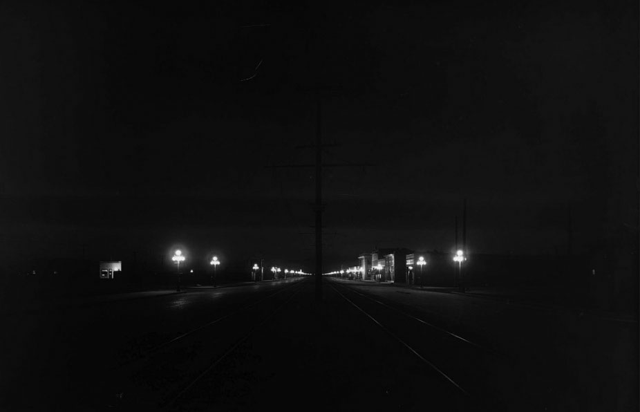
| (1913)*** – Night view looking south on Sherman Way (later Van Nuys Boulevard). Two rows of 5-lamp electroliers illuminate the area showing two sets of tracks and an electrical pole line running down the commercial center of town. |
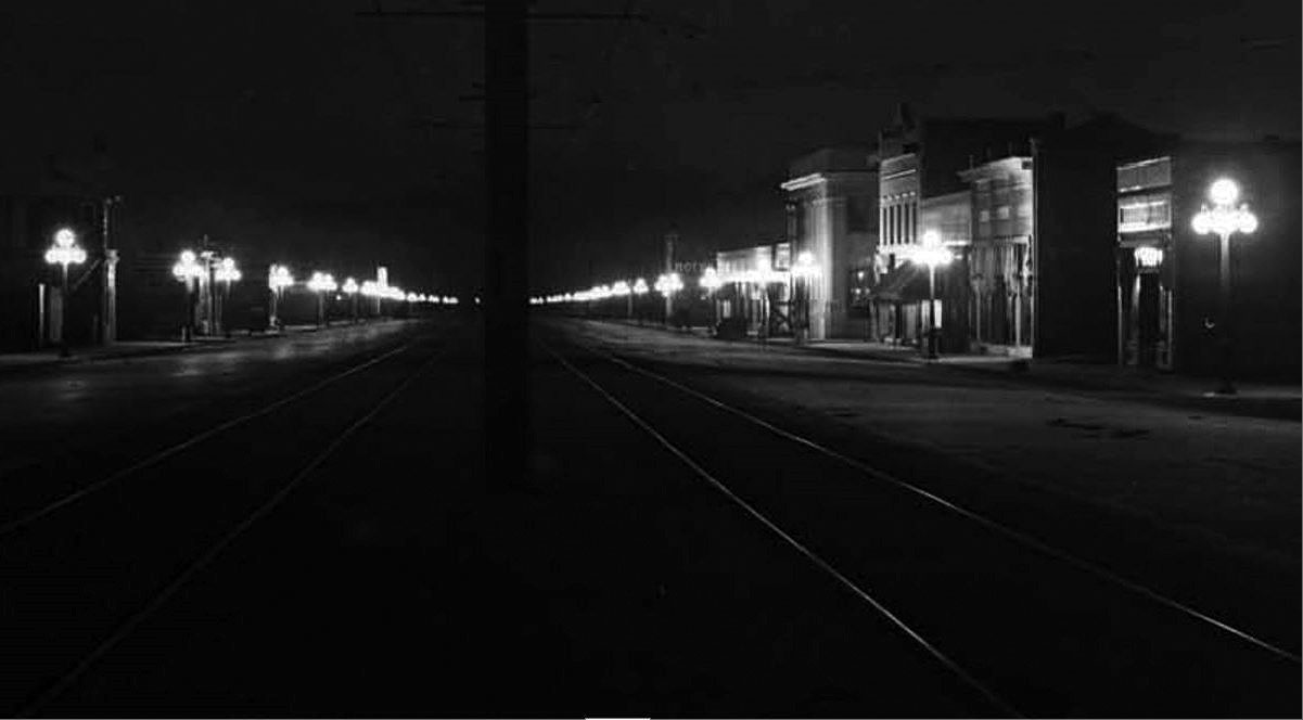 |
|
| (1913)*** – Closer view of Sherman Way (later Van Nuys Boulevard) showing the multitude of 5-lamp streetlights lining both sides of the street. Also seen are streetcar tracks and and an electrical pole line running down the center of the Boulevard. This is a blow-up of the previous photo. |
.jpg) |
|
| (1913)*** – Close-up detailed view showing a five light ornamental lamp. Street sign on lamp post reads: SHERMAN WAY. Sign on left reads: “Electroliers Wired & Installed by Llewellyn Iron Works”. Sign at right reads: “Private Road – Exclusively for Autos”. |
Historical Notes In the three townsites of Van Nuys, Marian, and Owensmouth, five-light clusters were used thru the main parts, four electroliers to every street intersection. On these five-light posts, one 60-watt lamp was upright and four 40-watt lamps pendant, and they were placed through the main parts of the towns, four electroliers to every street intersection.* The most common of the incandescent multiple globe electroliers of the early 1900s were those manufactured by the Llewellyn Iron Works of Los Angeles. The firm became so identified with this style of street light that any multiple globe electrolier became commonly known as a Llewellyn. The Llewellyn Iron Works, founded in 1889‐1890, was one of the largest metal working facilities in Los Angeles. It manufactured structural steel – including that for the Bradbury Building.^ |
 |
|
| (ca. 1913)^.^ – View looking down on an unpaved Sherman Way showing an ornate Llewellyn Iron Works 3-lamp electrolier. |
Historical Notes Cast-iron electroliers (made by Llewellyn Iron Works of Los Angeles) were used with three-light clusters for use along the boulevard outside the townsites, one 60-watt lamp upright and two 40-watt lamps pendant. The electroliers were located 330 feet apart staggered, or 660 feet apart on each side of the boulevard, which is about 100 feet wide.* These ornate streetlights (both 3-globe and 5-globe) still exist today. They can be found on Carroll Avenue in Angelino Heights (near Echo Park). |
 |
|
| (1914)* – Sketch from LA Times article announcing the celebration when all of the new streetlights were turned on along Sherman Way in June 1914. It shows the original route of Sherman Way, which today is west on Chandler, north on Van Nuys Blvd, and west on Sherman Way. The other sections of today's Van Nuys Blvd were known as South Sherman Way and North Sherman Way. |
Historical Notes The LA Times article was titled: League of Brilliant Lights in Unique and Rosy Outdoor Spectacles, reads: “Blaze of Light to Stretch for Miles. City, State and County Officials, With Thousands of Other Visitors, to Aid in Celebrating Completion of Magnificent Boulevard System in the San Fernando Valley… “. Click HERE to see article. |
* * * * * |
Sherman Way (Owensmouth Road Race)
 |
|
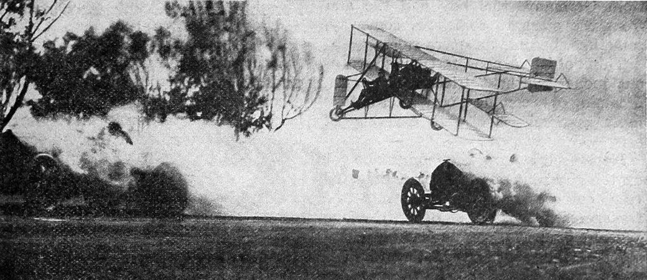
| (1913)* - Two cars racing, partly obscured by clouds of dust, with aviator Glenn Martin piloting biplane above serving as race referee. This photograph appears on page 415 of Popular Electricity magazine, Vol. VI, no. 1, May, 1913; the Owensmouth Road Race is covered in the Los Angeles Times, March, 1913. |
Historical Notes The Owensmouth Road Race in 1913 featured a unique promotional element: an airplane. Aviator Glenn Martin piloted a biplane and served as the race referee, a detail confirmed by a 1913 publication stating, "Martin referees car race in air." The scene, with two cars racing through clouds of dust and Martin flying above, epitomized the race's promotional activities. This use of an airplane to oversee and promote the race was part of a broader spectacle designed to showcase the modernity and infrastructure of the newly established town of Owensmouth. Held on March 27, 1913, the race was a significant event in the early history of Owensmouth, now known as Canoga Park. It was part of efforts to promote the town, founded on March 30, 1912, and featured prominent auto racing pioneer Barney Oldfield, receiving extensive coverage from the Los Angeles Times. Owensmouth was created during a period of rapid development in the San Fernando Valley, spurred by improved transportation options like electric railways and automobiles, and the anticipation of water from the Owens Valley. Initially part of a large tract of land owned by Isaac N. Van Nuys, it was sold to the Los Angeles Suburban Homes Company in 1909. This syndicate included influential figures such as Harry Chandler and Harrison Gray Otis of the Los Angeles Times, and developer Hobart Whitley. The Owensmouth Road Race was among many promotional activities organized to attract attention and settlers to the area. The event included a free barbecue, an air show, and live music, culminating in a race between a biplane and a Fiat sports car. These efforts were part of a broader strategy to transform the San Fernando Valley from agricultural land into a suburban area. |
 |
|
| (1913)* – Postcard view looking east showing early model cars and ornate streetlights on Sherman Way, one of the earliest paved roads in the San Fernando Valley. |
Historical Notes Sherman Way became the first paved boulevard across the valley. Following this was the paving of the state highway aka the Ventura Road, from the Cahuenga Pass to Newbury Park. Eventually, the road ran all the way to Ventura, and was renamed Ventura Boulevard. |
 |
|
| (1913)* – View looking east on Sherman Way showing the General Moses Sherman-built PE tracks at right. Ornamental lighting posts can be seen on the left. |
* * * * * |
.jpg) |
|
| (1919)* – Map showing the San Fernando Valley routing of Pacific Electric streetcars (yellow) and Southern Pacific trains (red) in 1919. Image courtesy of Barry Lawrence Ruderman Antique Maps (RareMaps.com) |
Historical Notes General Moses Sherman directed the Los Angeles Pacific Railroad electric railway line's construction. It ran from Lankershim to the three new towns the syndicate's partner Hobart Johnstone Whitley had planned for the valley, Van Nuys, Marian (present day Reseda), and Owensmouth (present day Canoga Park and West Hills). The tracks ran in the middle of Sherman Way, a broad new 'lavishly landscaped' and paved avenue to the Owensmouth terminus. |
Marian Pacific Electric Station (later Reseda)
 |
|
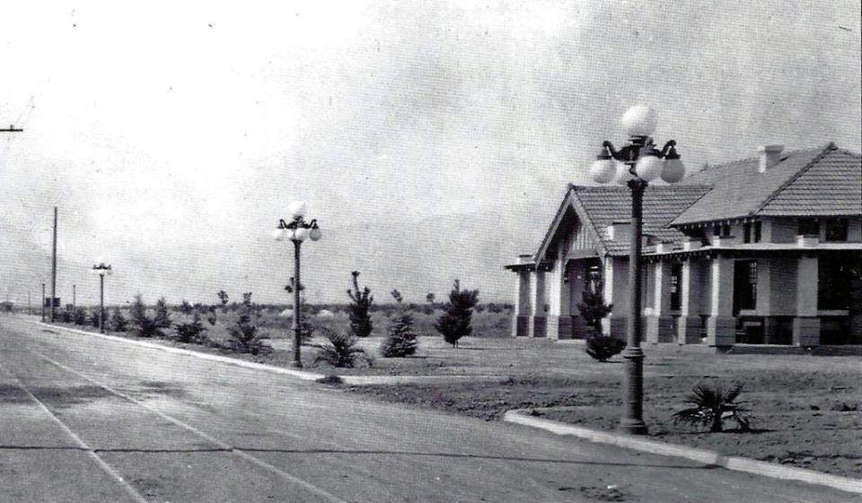
| (1920s)#^*^ - View of the Pacific Electric Station near Reseda and Sherman Way. It later became the Reseda Women's Club meeting room. |
Historical Notes Reseda originated as a farm town named "Marian" (or "Rancho Marian") that appeared in 1912. Its namesake, Marian Otis Chandler, was the daughter of Los Angeles Times publisher Harrison Gray Otis, a director of the Los Angeles Suburban Homes Company. H J Whitley was the manager of the Los Angeles Suburban Home Company.*^ |
Owensmouth Pacific Electric Station (later Canoga Park)
 |
|
| (ca. 1913)^ - View showing the Owensmouth PE station looking west along Sherman Way. Park Ave [now Vassar Ave] enters at right; behind the Simi Hills can be dimly seen. Note the five-lamp ornamental streetlights along Sherman Way. |
Historical Notes Sherman Way became the first paved boulevard across the valley. Following this was the paving of the state highway aka the Ventura Road, from the Cahuenga Pass to Newbury Park. Eventually, the road ran all the way to Ventura, and was renamed Ventura Boulevard. |
Then and Now
 |
|
| (1913 vs 2023)* - Looking west on Sherman Way at Vassar Ave. |
Owensmouth (later Canoga Park)
 |
|
| (1917)**^^ - Before there was Canoga Park, there was Owensmouth, born on the barley fields of the San Fermando Valley on March 30, 1912. Detail of a 1917 strip map courtesy of the Automobile Club of Southern California. |
Historical Notes Founded on March 30, 1912, the settlement -- renamed Canoga Park in 1931 -- represented one of L.A.'s first steps in a march that eventually transformed the San Fernando Valley from farmland into suburbia. Owensmouth was at the vanguard of a land boom in the San Fernando Valley. For decades, two factors prevented development in the Valley: its remote location, separated by the Santa Monica Mountains from the population and business center of Los Angeles; and the opposition of a few large landholders, who preferred to maintain the valley for agricultural use. By the end of the twentieth century's first decade, however, electric railways and the growing popularity of automobiles shrunk the distance between the city and the Valley. Also, One landowner, Isaac N. Van Nuys, was willing to sell. The aging farmer, banker, and land baron controlled the Los Angeles Farming and Milling Company, which owned a vast tract totaling 47,500 acres and constituting much of the southern half of the San Fernando Valley.**^^ |
 |
|
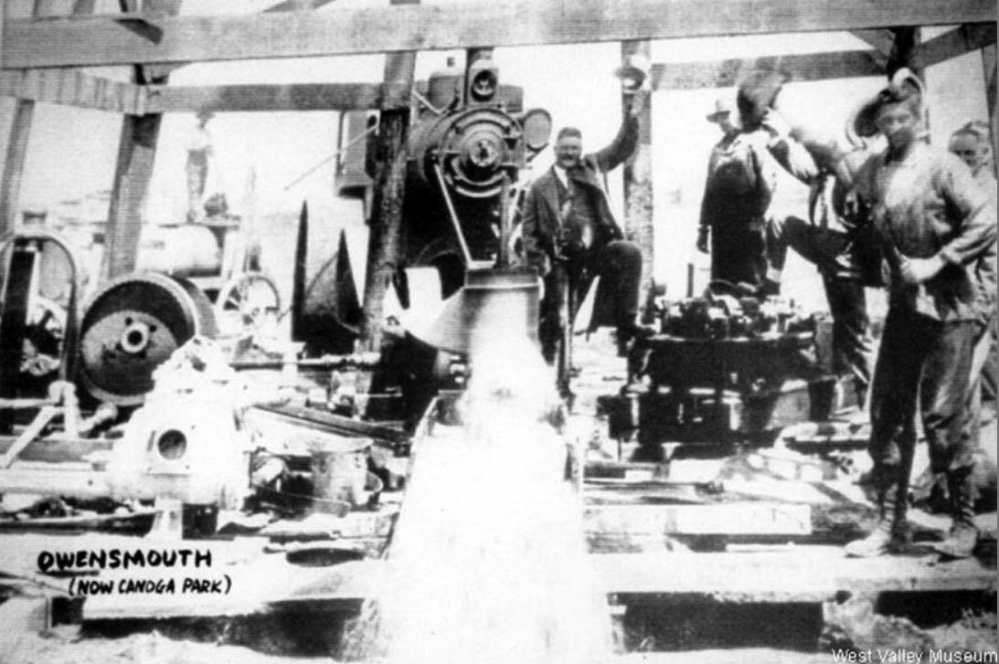
| (ca. 1910s)^- Water well in Owensmouth installed by the town’s developers near today's intersection of Sherman Way and Deering Avenue. |
Historical Notes In April 1910, a rig was set up to drill Well No. 3 near Canoga Station (south of Sherman and east of Deering), and In October, a pump was installed and a fifty-horsepower gas engine to run it. The well was delivering water by March of 1911. #^*^ |
 |
|
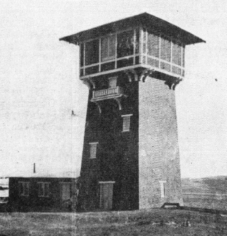
| (1911)#^*^ – View showing the Owensmouth pump house and water tower located south of Sherman Way and east of Deering Ave. This was Owensmouth's water supply until water came in from the LA Aqueduct in 1917. |
Historical Notes Prior to the opening of the aqueduct, the valley had few sources for water. One source was this well on the south side Sherman Way and east of Deering, providing the early water needs for the town of Owensmouth. The well had a pumping capacity of 20,000 gallons. Whitley and Otis had declared the well sufficient to supply the needs of a population of 10,000, a claim which, fortunately, never had to be put to the test. #^*^ |
 |
|
| (1916)#* – View looking southwest showing Southern California Edison’s Owensmouth Substation located on Sherman Way and Market Street (later Deering Ave). In the background, on the right, is Woods Lumber Co. (opened in 1912), located near Sherman Way and Owensmouth. By January it became the Owensmouth Feed and Fuel Company, shipping valley beans across the country. |
Historical Notes Southern California Edison (SCE) provided electric power to the area in the early part of the century. Even though Owensmouth was annexed by the City of Los Angeles in 1917, it would take another 20 years for the Bureau of Power and Light (later DWP) to completely take over all of SCE’s facilities. Click HERE to see more in First Electricity in Los Angeles. |
 |
|
| (1912)^ - The Knapp home at Owensmouth Avenue and Cohasset Street in Canoga Park. View looking northwest. It was one of the first houses in the area. Knapp Park and Knapp Street is named for these same Knapps. The men of the Knapp family were stone builders and did much of the stone work at Orcutt Ranch. |
Historical Notes The Knapp house, razed in 1926, was located on the NW corner of Owensmouth Avenue and Cohasset Street. Today there are only palms trees on the lot where the house once stood. Click HERE for contemporary view. Owensmouth Avenue was named after 'Owensmouth', designed to evoke an image of being at the mouth of the distant Owens River and was the original name of the settlement that grew into the town of Canoga Park.^* Click HERE to see more SFV Street Name Origins. |
 |
|
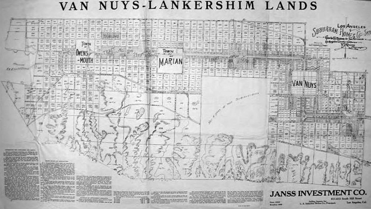
| (1912)#* – Suburban Homes Company map of the Van Nuys–Lankershim Lands covering the area from the Town of Owensmouth (now Canoga Park) through the Town of Marian (now Reseda) to Van Nuys, with the Santa Monica Mountains to the south. Ventura Freeway now follows the Southern Pacific right of way. "Not a part of this Subdivision" is today's Sepulveda Basin. Properties with circled numbers had been sold. |
Historical Notes In 1909, Isaac Van Nuys sold his farmland for $2.5 million to a syndicate named the Los Angeles Suburban Homes Company. The syndicate's Board of Control comprised Los Angeles' leading movers-and-shakers: Title Insurance and Trust Company head Otto F. Brant; Los Angeles Times business manager Harry Chandler, a friend of Van Nuys'; Times owner Harrison Gray Otis, Chandler's father-in-law; transit magnate Moses H. Sherman; and developer Hobart Whitley, hailed today as the "father of Hollywood." Thirty participants drawn from L.A.'s business elite joined the board members as investors.**^^ |
 |
|
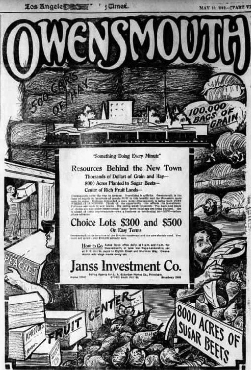
| (1912)^.^ - LA Times ad for Owensmouth put out by the Janss Investment Company. Janss would go on to develop Westwood and Westwood Village in the 1920s. |
Historical Notes The Janss Investment Company, which the syndicate hired to subdivide Owensmouth, platted the town around the junction of the Southern Pacific tracks and Sherman Way. Throughout 1911, as construction on Sherman Way raced westward from Van Nuys, workers rushed to provide the planned town with its basic needs: a water tower capable of supporting a population of 10,000, according to the syndicate's claims; a passenger depot along the Southern Pacific line; and a mission-style building where Janss could sell lots.**^^ |
Syndicate Block (aka Arcade Block)
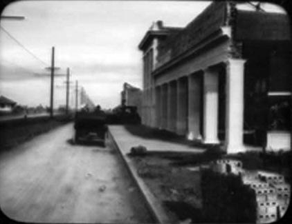 |
(ca. 1912)#^ -
View of the Syndicate Block in Owensmouth. Later known as the Arcade Block, it stood on the south side of Sherman Way between Alabama and Remmet avenues. |
 |
|
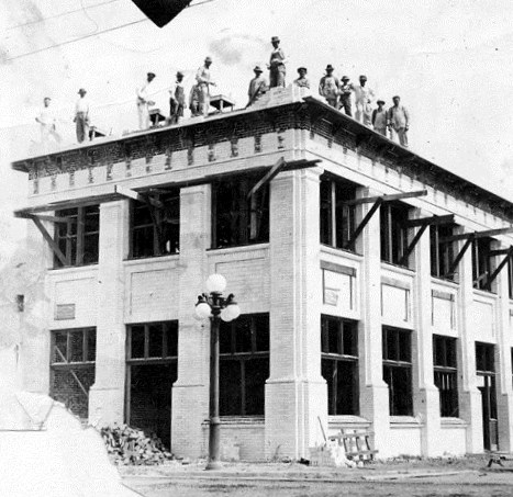
| (1912)^ - Construction on the first of the buildings that made up Syndicate Block, at the corner of Remmet Avenue and Sherman Way. It was later called Arcade Block. |
Historical Notes This building is part of the Syndicate Block, which was built by prominent investors in the San Fernando Valley. It was the first commercial building constructed after the Owensmouth Station was built. Tracks ran down the center of Sherman Way.#^ |
 |
|
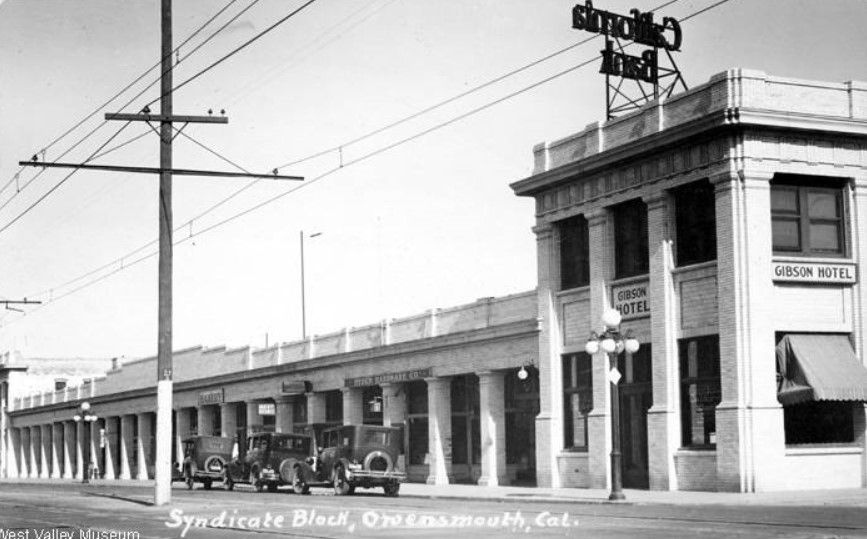
| (1920)#^ - View of Sherman Way looking east at Remmet Avenue. The full length of the Syndicate Block can be seen. Click HERE to see more views of the Syndicate Block (later Arcade Block - 1940s +) |
Historical Notes Signs on the commercial building include: Gibson Hotel, Hyden Hardware Co., and California Bank. Owensmouth struggled through its first few years. Electricity did not arrive until 1913; natural gas came years later. By 1916, only 200 residents called the four-year-old town home, and residents and farmers could not enjoy the water to which their town's name referred; only after Los Angeles annexed Owensmouth in 1917 did aqueduct water flow into town and into the surrounding orchards and citrus groves.**^^ |
 |
|
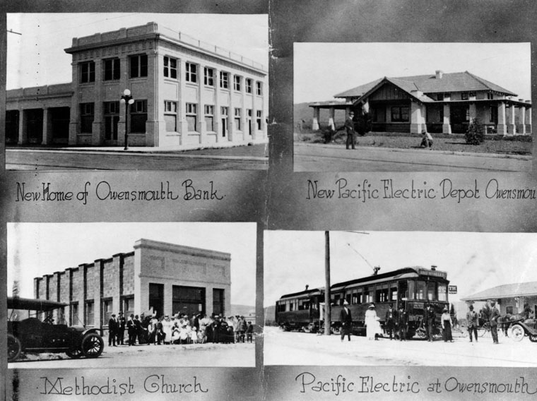
| (1914)* - Four buildings in Canoga Park (formerly called Owensmouth): Owensmouth Bank, Pacific Electric depot Owensmouth, Methodist Church, and, Pacific Electric at Owensmouth, 1914. |
Historical Notes When the Southern Pacific built a branch line through the area, it designated the spot Canoga, after the town of Canoga, New York, which in turn took its name from the Indian village of Ganogeh ("place of floating oil"). In 1931, Owensmouth became Canoga Park. (The Post Office insisted on adding "Park" to avoid confusion with Canoga, New York.)**^^ |
 |
|
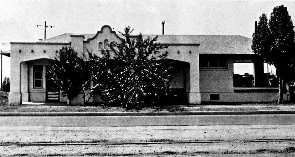
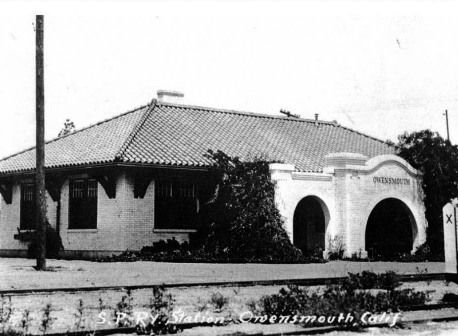
| (ca. 1915)^ – View showing the Owensmouth Southern Pacific Train Depot located at 21355 Sherman Way, on the northeast corner of Sherman Way and Canoga Ave. It would later become Dicecco’s Hardware Store. |
Historical Notes Built in 1912, the Owensmouth's Southern Pacific Railroad Station was one of the few Spanish Revival railroad Stations in the Valley to survive to the late 20th century. It was declared an historic-cultural monument on May 30, 1990. In 1995 it was damaged by fire and razed.^ |
* * * * * |
 |
|
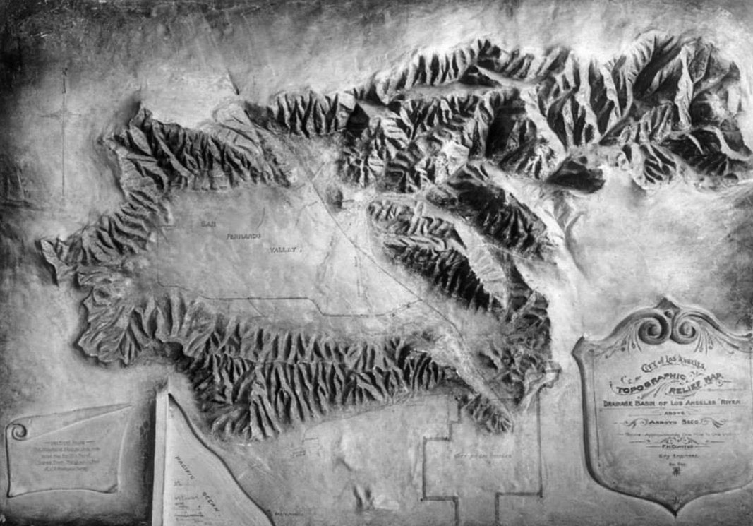
| (1912)^^*^^ – Topographical relief map titled "Drainage Basin of Los Angeles River." The San Fernando Valley can clearly be seen. It’s so vast that when you’re inside it, you can’t fully see it. |
 |
|
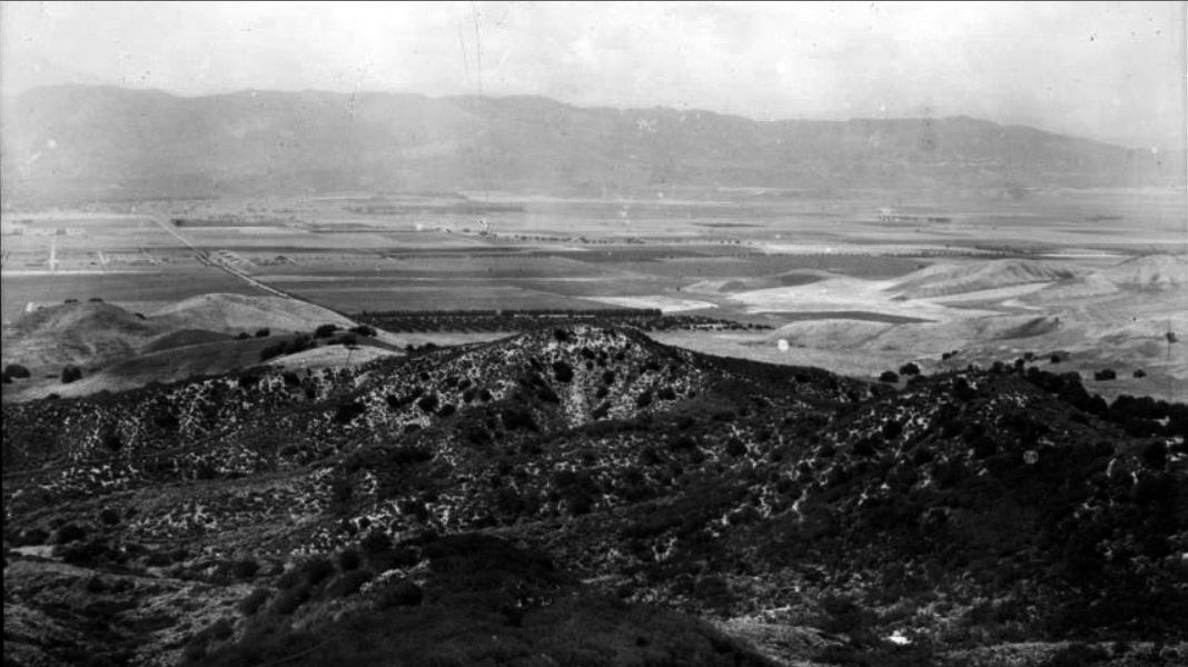
| (ca. 1914)^^ - Panoramic view of the San Fernando Valley from near Topanga Canyon Road. The wide, flat valley is in the distance at center and is divided into many large farm plots. A small orchard is visible at center and a road cuts through the valley at left. The foreground is occupied by steep, wooded hills, and there are large mountains visible in the background. |
 |
|
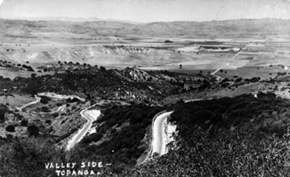
| (1915)^ - View of new Topanga Highway winding down north slope into a nearly vacant West San Fernando Valley. |
* * * * * |
Please Support Our CauseWater and Power Associates, Inc. is a non-profit, public service organization dedicated to preserving historical records and photos. Your generosity allows us to continue to disseminate knowledge of the rich and diverse multicultural history of the greater Los Angeles area; to serve as a resource of historical information; and to assist in the preservation of the city's historic records.
|
More Historical Early Views
Newest Additions
Early LA Buildings and City Views
History of Water and Electricity in Los Angeles
* * * * * |
References and Credits
* LA Public Library Image Archive
^ CSUN Oviatt Library Digital Archives
#^San Fernando Valley History Digital Library - CSUN Oviatt
** DWP - LA Public Library Image Archive
^* The Valley Observied: Street Name Origins; Timeline of Valley History
^# Chatsworth Historical Society; Chatsworth History Timeline; Post Office Poster; Chatsworth Hills Homesteaders
*# Mojave Desert.net: Remi Nadeau
*^^LA Flood of 1938: Cement the River's Future (KCET)
***Los Angeles Historic - Cultural Monuments Listing
*^*California Historical Landmarks Listing (Los Angeles)
^^^LA Times: Adohr Spelled Succes for the Adamsons; Fred Weddington
^^*LA Times: Stanley Norris Petit
*##LA Times: Dig Into History You'll Find Snake Oil..Victor Girard Kleinberger
^##ReoCities: The Chatsworth Tunnels
##+Daughters of the American Revolution: Chatsworth Chapter
###Los Angeles Historical Society
#^^LA River Railroads - Burbank Branch History
#**California State Library Image Archive
#^#San Fernando Valley Blog: Van Nuys Blvd Streetcar Tracks
*#*Project Restore: Van Nuys City Hall
^*^Topanga Canyon History - LA Magazine
*#^LA World Airports - History of Van Nuys Airport
^^#The Museum of the San Fernando Valley
**#Tumblr.com: LA History - Leonis Adobe
^#*Photo of the Northeast San Fernando Valley ca.1950 - Laurie Burns
^*#North Hollywood-Toluca Lake Patch: History of the Laurel Canyon and Valley Plaza Mall; N. Hollywood Train Depot; Weddington House
*^##SCVhistory.com: Beale's Cut
*###California Department of Transportation
**^^KCET: Canoga Park at 100: A Brief History of the Birth of Owensmouth
**^#LA Times Framework: Sepulveda Tunnel
**#^San Fernando Valley Historical Society
*^^^San Fernando Valley Historical Society/Facebook.com Hotel Cecil; 1st Mail Wagon; Whitley Mansion; Van Nuys PE Depot; Toluca Flyer
^^^*San Fernando Valley Relics: Chatsworth Tracks; Beale's Cut
^*^*Metro.net: PE Line Reaches Van Nuys
^^#^Facebook.com - Great Photos from Los Angeles' Past: Van Nuys PE Railroad; Porter Ranch Farmers
*#^#Forum.skyscraperpage.com: Beale's Cut; Hotel Cecil
*#*^Openlibrary.org: Westinghouse Automatic Electric Range
*#^^Big Orange Landmarks: Old Stagecoach Trail
*#^*Los Angeles County Library: Agoura Hills; City of San Fernando
*#*#California Museum: A Journey Along the El Camino Real
#^*^Facebook.com: West San Fernando Valley Then And Now
#**#History of Funeraria del angel Praiswater
#*^#Google Maps and Street Views
#^^^City of Calabasas: cityofcalabasas.com
***^^Pacific Electric Inventory - libraryarchives.metro.net/
****^Facebook: San Fernando Valley Blog
*^*^*Los Encinos State Historic Park: historicparks.org
^^*^^Facebook.com: Garden of Allah Novels
*^^^*RareMaps.com
*^^^#DWP - Water and Power Associates Historical Archives
^***^Pacific Electric San Fernando Valley Line - ERHA.org
*^ Wikipedia: Sherman Oaks; Isaac Van Nuys; Encino; Tarzana; Campo_de_Cahuenga; Cahuenga Pass; Chatsworth; Panorama City; Santa Susana Field Laboratory; North Hollywood; Canoga Park; Woodland Hills; Reseda; Orcutt Ranch; Granada Hills; Andrés Pico; Moses Sherman; Van Nuys; Henry Kaiser; Charles Maclay; San Fernando Valley; Mission Point; Hughes Aircraft; Domonique Amestoy; Winnetka, Los Angeles; City of San Fernando; Canoga Park High School; Ventura Freeway; Hollywood Freeway; Los Angeles Valley College; Domonique Amestoy; Los Encinos State Historic Park; H.J. Whitley; Lankershim-Van Nuys Pacific Electric; Van Nuys High School
< Back