Early Views of the San Fernando Valley
 |
|
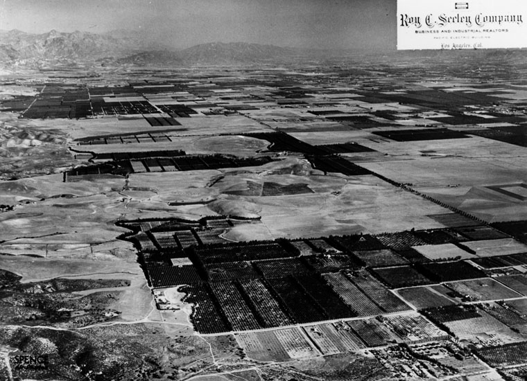
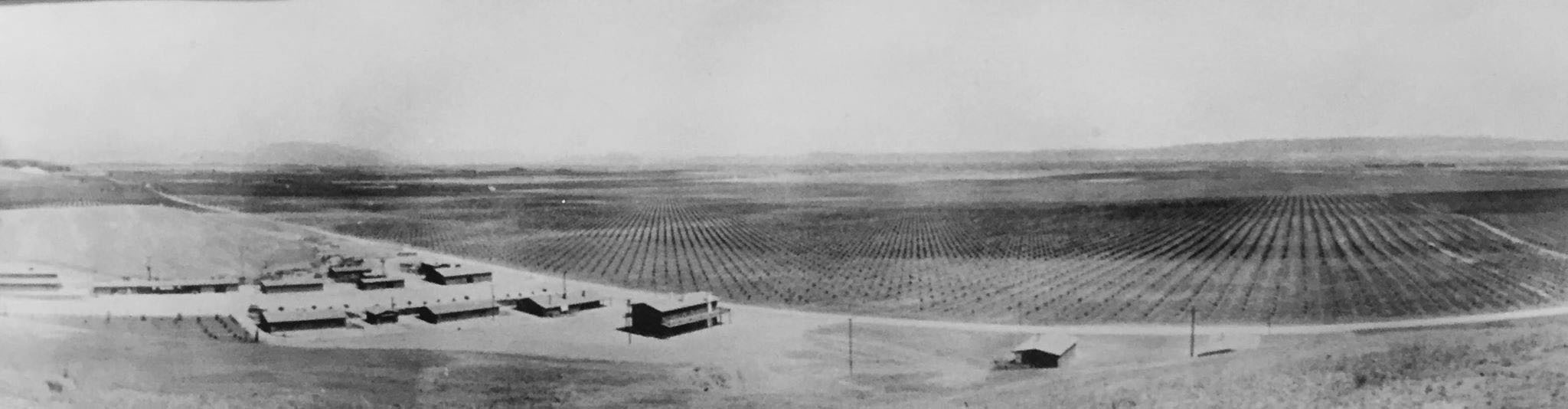
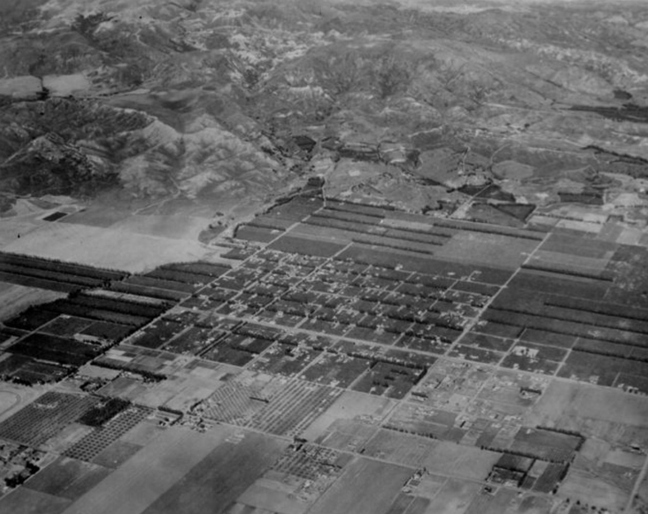
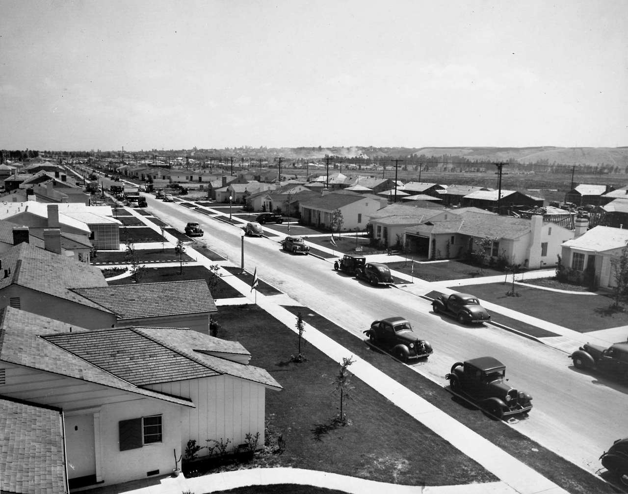
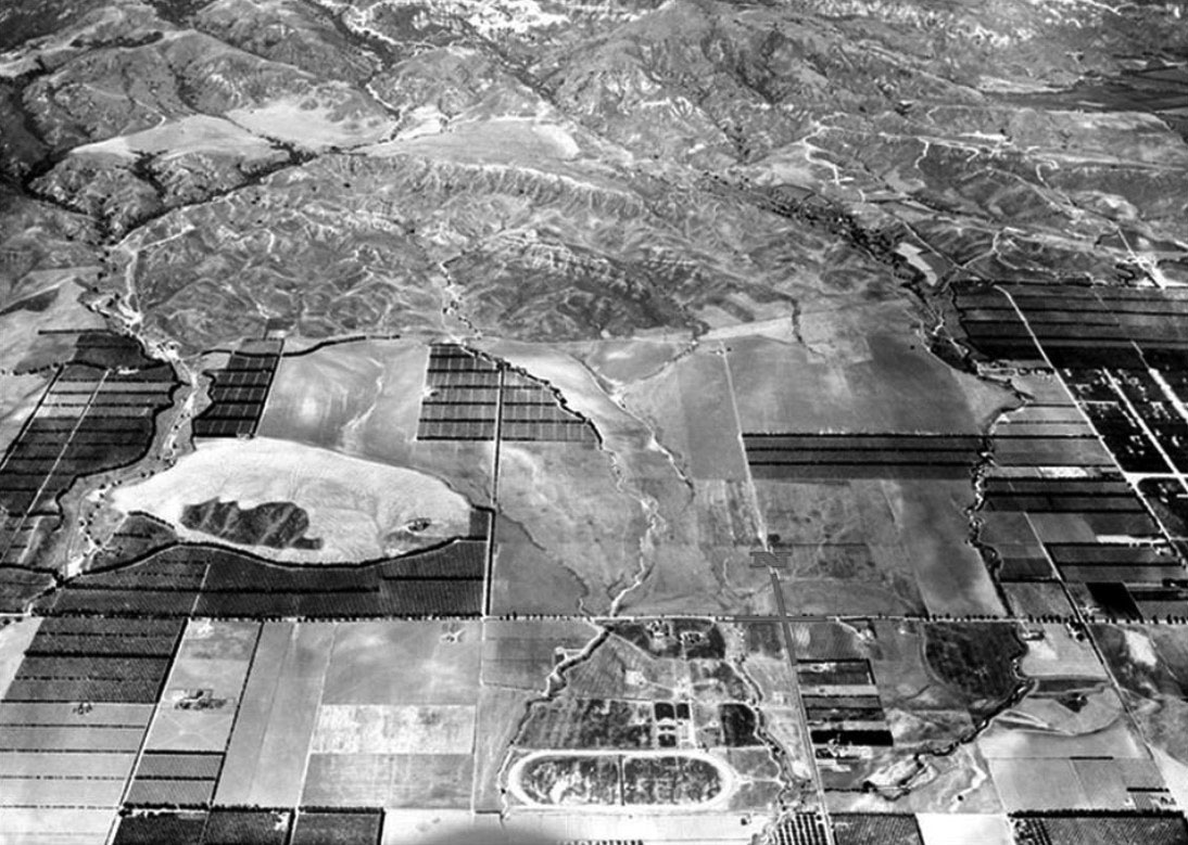
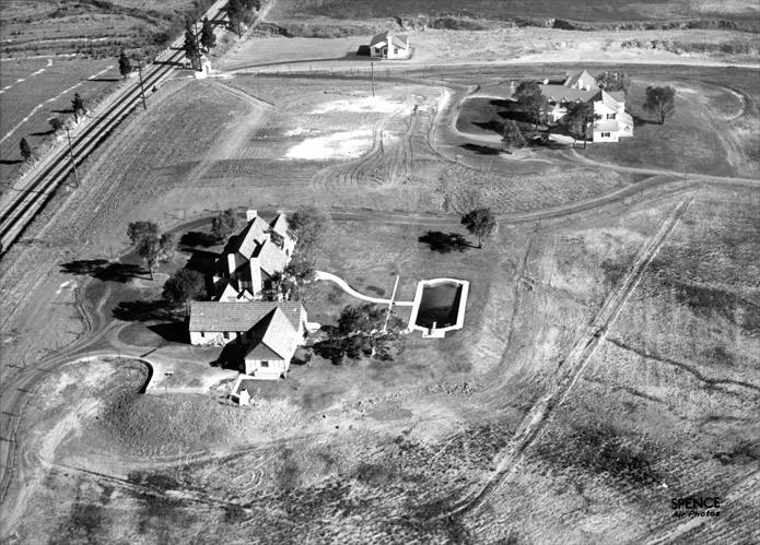
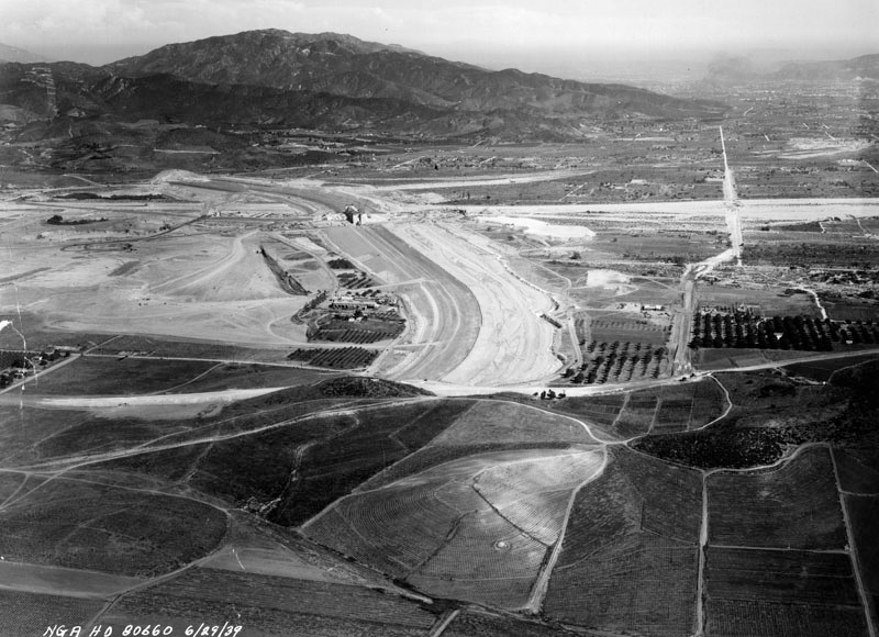
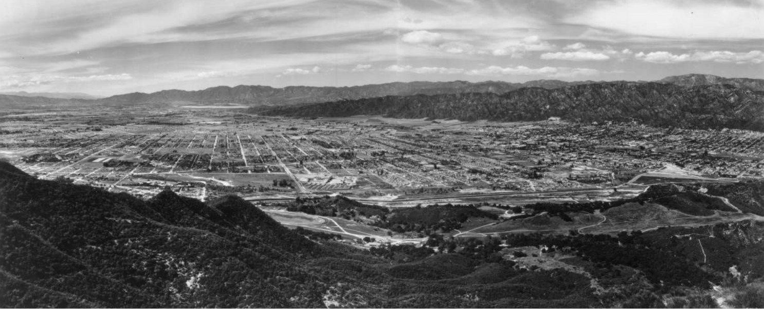
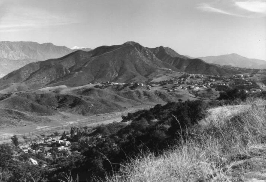
| (1936)* - Aerial view of Chatsworth, looking southeast. Devonshire Street can be seen running across the San Fernando Valley (lower right-center diagonally up to upper left-center of photo). |
Historical Notes The present town was first called 'Chatsworth Park' and developed in 1888. It was named after Chatsworth House, the family seat of the Duke of Devonshire in Derbyshire, United Kingdom. The Devonshire name was also used for the naming of the major east-west boulevard in Chatsworth. |
.jpg) |
|
| (1936)* - Illustrated map of a tour to the San Fernando Valley. Note how Topanga Canyon Boulevard stopped at Devonshire. Beyond Devonshire it would turn into Santa Susana Ave. |
Historical Notes Tour Description: Starting at City Hall in downtown Los Angeles, the tour goes west on Sunset through Hollywood, north over Cahuenga Pass to North Hollywood and Universal City, on to Van Nuys via Lankershim and Victory Blvd. and continues via Van Nuys Blvd. to the city of San Fernando which is bordered by Verdugo Hills and the San Gabriel and Santa Susana Mountains. The route turns west, passes the San Fernando Mission and continues on Devonshire St. to Chatsworth. From there it goes south to Canoga Park on Topango [sic.] Canyon Blvd., then east on Ventura Blvd., passing the Chalk Hills, the cities of Tarzana, Encino and Sherman Oaks and the Hollywood Country Club and turns south at the Cahuenga Pass and back to City Hall. |
 |
|
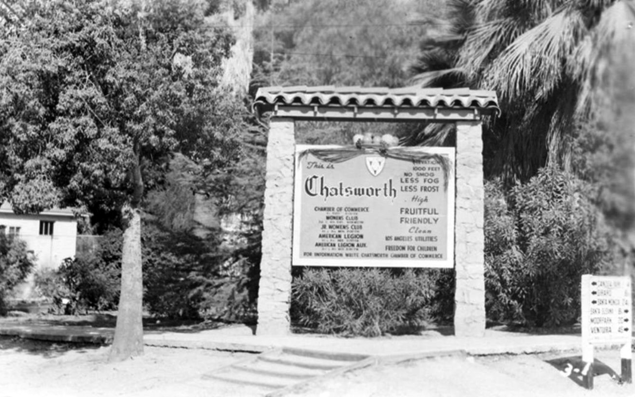
| (1950)* - Postcard view showing the landmark Chatsworth sign that was located on the northwest corner of Devonshire Street at Santa Susana Avenue (now Topanga Canyon Boulevard). The sign was located in front of the Chatsworth Park Elementary School. |
Historical Notes The Duke of Devonshire's coat of arms is located at the top of the sign. The sign reads, "This is Chatsworth, elevation 1000 feet, no smog, less fog, less frost, high, fruitful, friendly, clean, Los Angeles utilities, freedom for children, Chamber of Commerce, Women’s Club, Jr. Women’s Club, American Legion, American Legion Aux, for information write Chatsworth Chamber of Commerce." On the far right, there is a sign that lists nearby neighborhoods and cities, and their distance from Chatsworth: Canoga Park 4, Girard 6, Santa Monica 24, Santa Susana 8, Moorpark 20, Ventura 45. |
 |
|
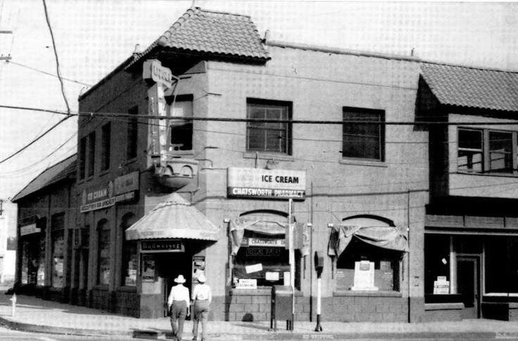
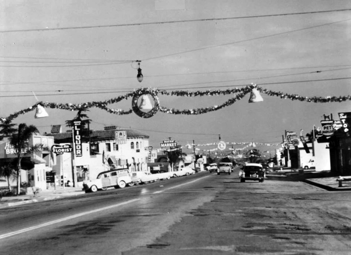
| (1940s)* – Two men are seen crossing Topanga Canyon Boulevard heading toward Chatsworth Pharmacy located on the southeast corner of Topanga and Devonshire. |
Historical Notes The building on the southeast corner of Devonshire St. and Topanga Cyn. Boulevard was the "Chrisler Building". It was built in 1928 and razed in the mid-1960’s. A Shell Gas Station was on the corner for many years and today a Chevron Service Station sits on the site. |
 |
|
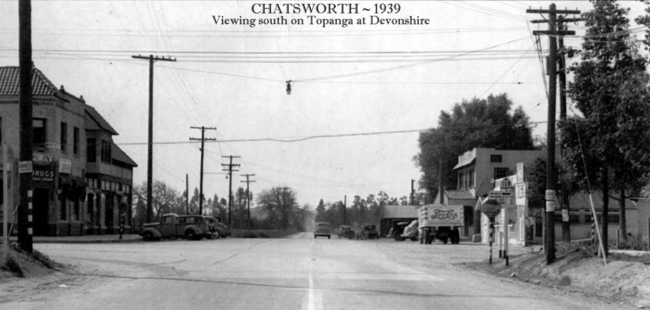
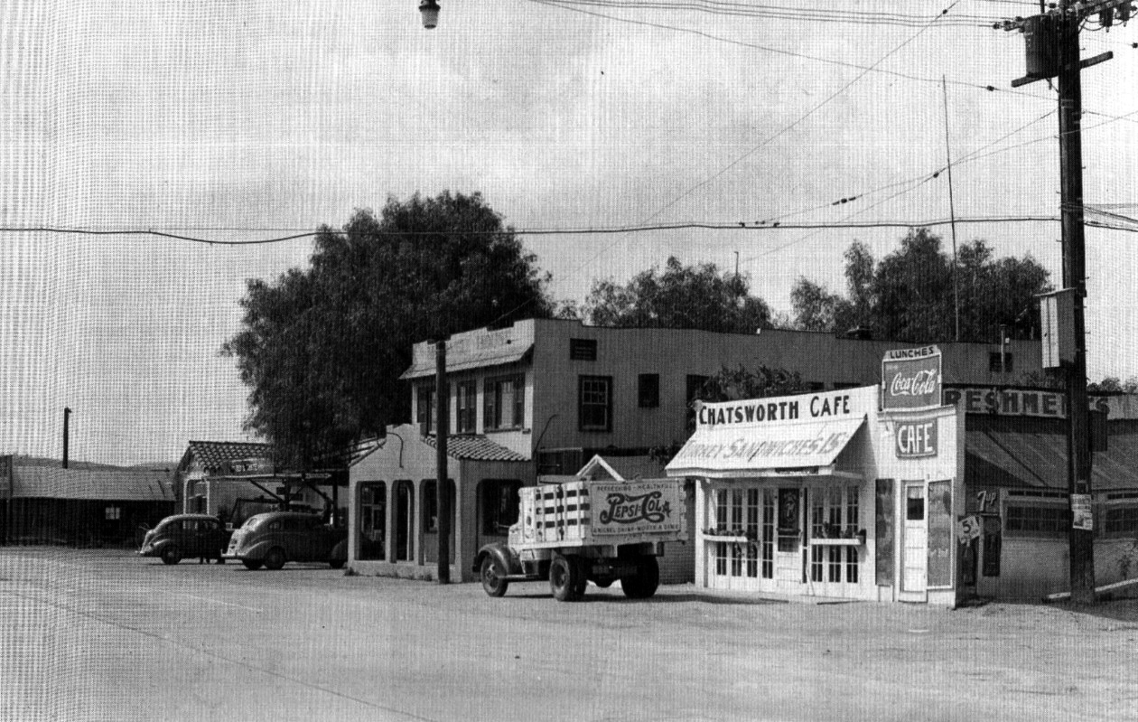
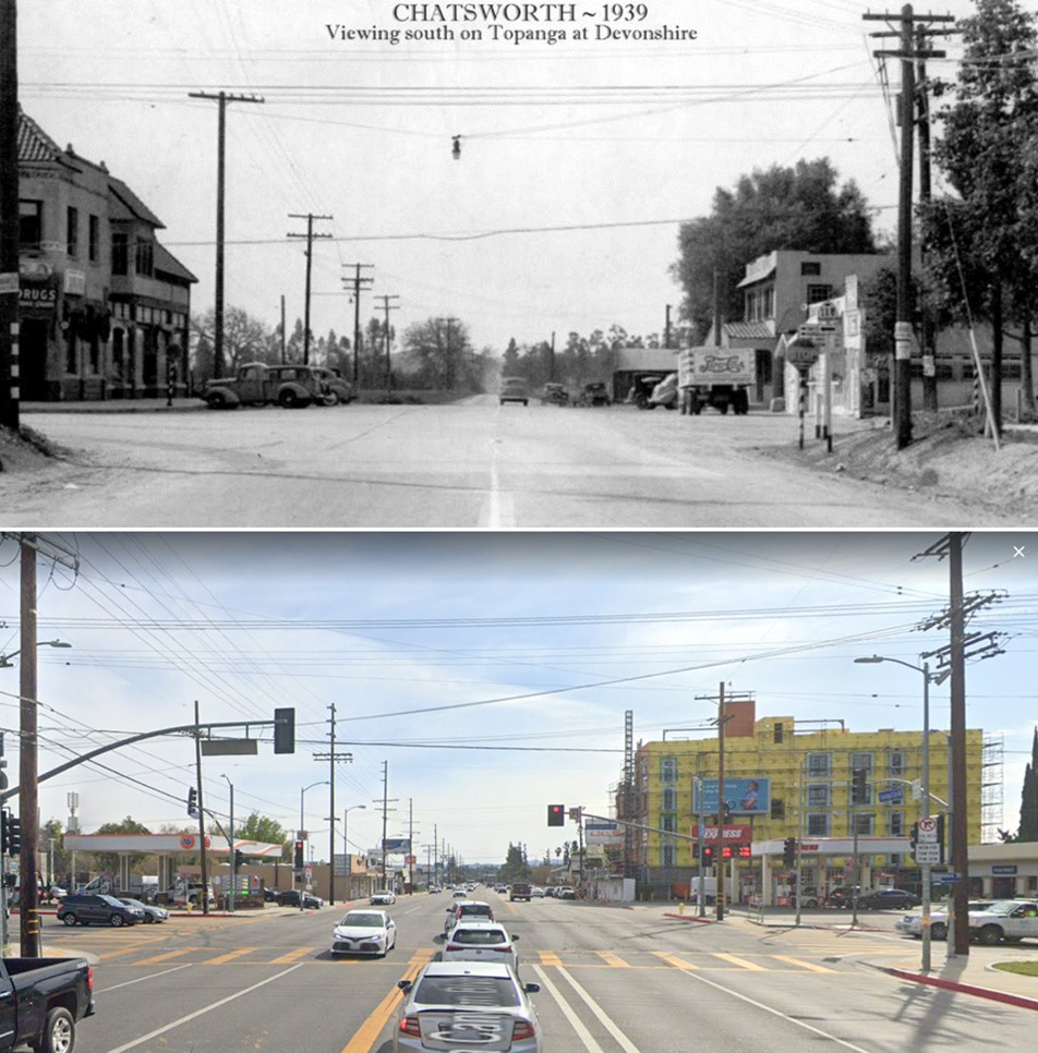
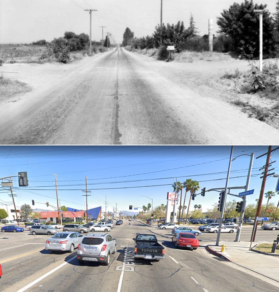
| (ca. 1939)* - Panoramic view looking south on then, 'Santa Susana Ave' (Now - Topanga Canyon Blvd) at Devonshire Street. Sign reading ‘118’, with arrow pointing east on Devonshire, is seen in the lower right (northwest corner). Also on the northwest corner (out of view) is the Chatsworth Elementary School. The 'Chrisler Building' can be seen on the left (southeast corner). A Pepsi-Cola truck is parked near the southwest corner on the right. |
Historical Notes The first school to be built on the N/W corner of Topanga (then Santa Susana Ave) and Devonshire was the Santa Susana School, established in 1890. In 1917, Chatsworth Park Elementary School was dedicated with a new building on the existing site. In 1933, the Long Beach earthquake caused severe damage and in 1935 the new Chatsworth Park Elementary School building was dedicated, with an Auditorium to follow in 1937. Before the Simi Valley Freeway was built, route (SR 118) went through Simi Valley on Los Angeles Avenue and Keuhner Drive, then crossed into the San Fernando Valley on Santa Susana Pass Road. The eastern segment used Devonshire Street through the San Fernando Valley. During the 1932 Summer Olympics, it hosted part of the road cycling event. Construction began on the 118 Freeway in 1968 and the last section opened in 1979. The segment of freeway between Balboa Boulevard and Tampa Avenue was one of the last freeway segments to be built in the Los Angeles area. |
 |
|
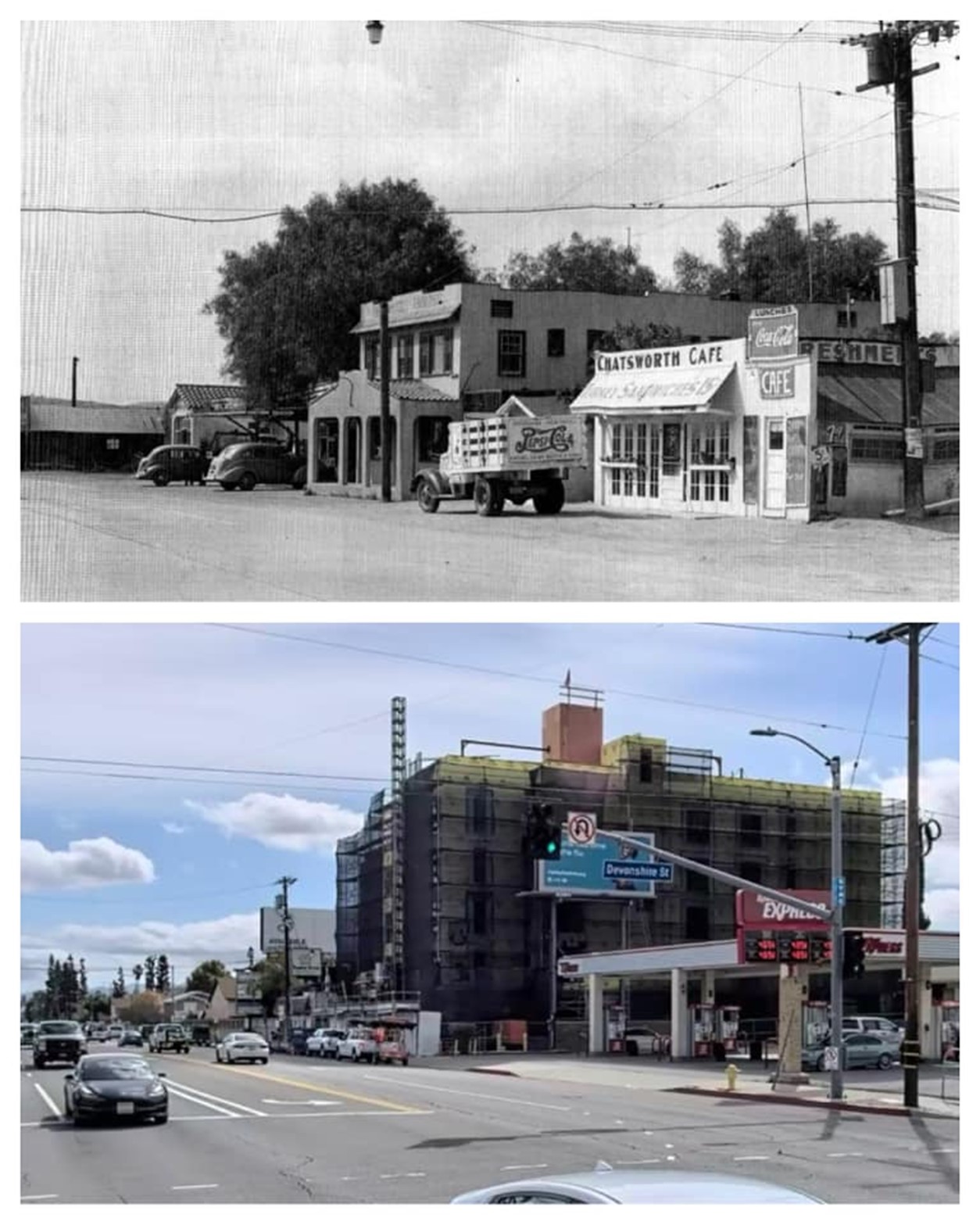
| (1939)* – The Chatsworth Café located on southwest corner of Topanga Canyon Boulevard and Devonshire Street with a Pepsi-Cola truck parked in front. Note that the coffee shop also displays signs for Coca Cola and 7UP. To its left stands the Maxwell House Apartments and the Chatsworth Service Station. |
Historical Notes The Chatsworth Café was used in an episode of Highway Patrol with Broderick Crawford and a very young Clint Eastwood. Also note the sign says 5¢. Coca-Cola inventor, John Pemberton, set the price for a fountain glass of Coca-Cola at 5¢ in 1886 and a bottle of Coke remained 5¢ until 1959! |
 |
|
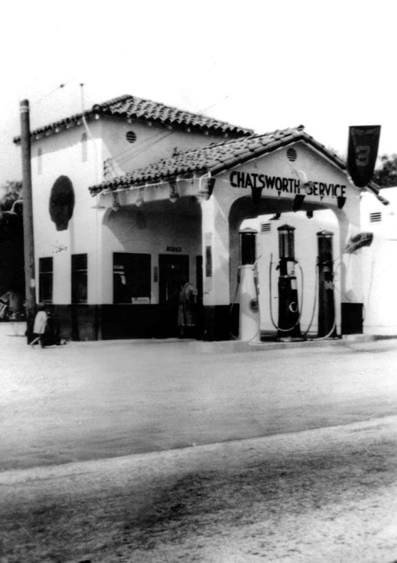
| (ca. 1930s)* – Close-up view of the Chatsworth Service Station located on the west side of Topanga south of Devonshire, as seen from across the street. Click HERE to see more Early LA Gas Stations. |
* * * * * |
Chatsworth Market
 |
|
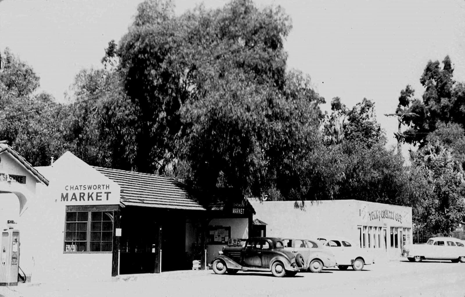
| (1949)* – View looking northwest showing the Chatsworth Market where the two-story Maxwell House Apartment building once stood (see earlier photo). Chatsworth Café (now with new name?) is seen on the right (SW corner of Topanga and Devonshire). The Chatsworth Service Station is on the left. |
 |
|
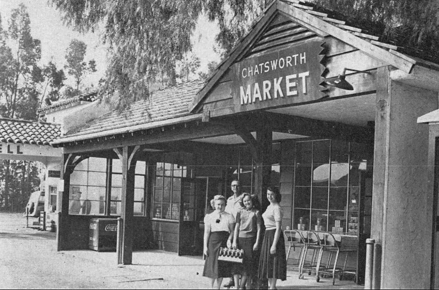
| (1951)* – View showing owner Russell McElvain and students Esther Lewis, Pat Lee and Joyce Amdisen standing in front of Chatsworth Market, 10249 Topanga Cyn Blvd. |
Historical Notes Russel McElvain had worked as a butcher for two previous owners before he and his wife Dorothy bought the market. |
* * * * * |
Topanga and Devonshire (NE Corner)
 |
|
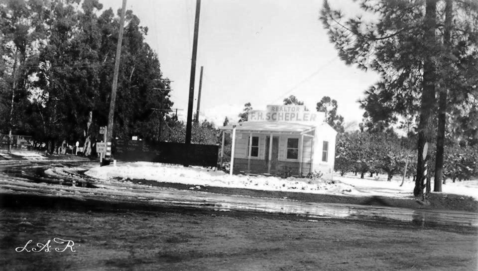
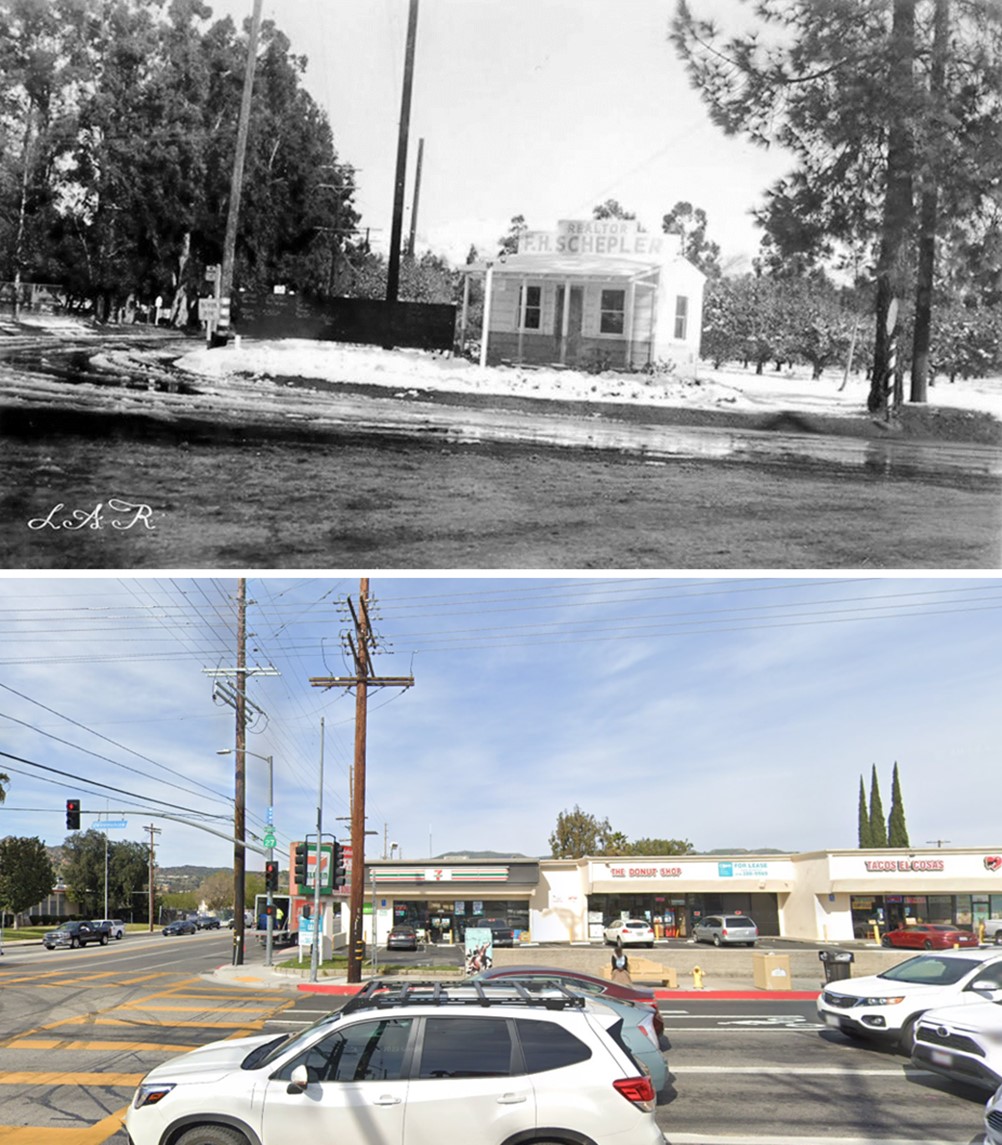
| (ca. 1949)* - View showing F.H. Schepler Realty at the NE corner of Devonshire & Topanga after a snow storm. A 7-11 is at this location now. Click HERE for contemporary view. |
Historical Notes Click HERE to see more Early Views of Snow in the San Fernando Valley. |
Topanga and Devonshire (NW Corner)
 |
|
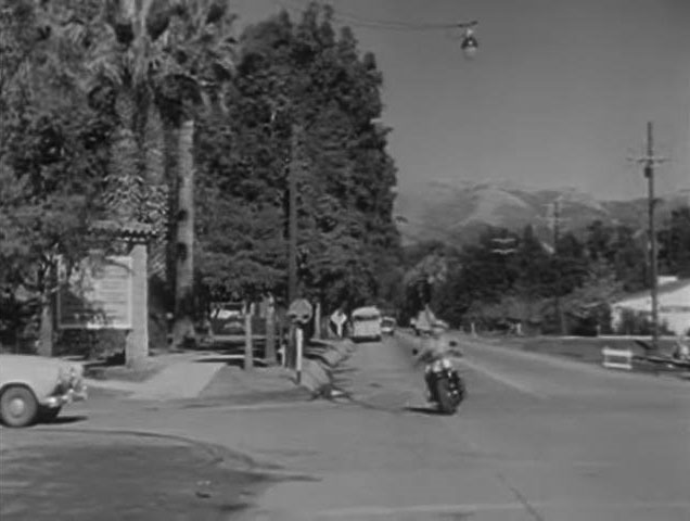
| (1956)* – Screen shot looking north on Topanga at Devonshire with Chatsworth Park Elementary School seen on the left (NW corner). |
Topanga and Devonshire (Then and Now)
 |
|
| (1939 vs 2023)* - Looking at the SW corner of Topanga Cyn at Devonshire in Chatsworth. Photo comparison by Jack Feldman. |
 |
|
| (1939 vs 2023)* - Looking at the SW corner of Topanga Cyn and Devonshire in Chatsworth. Photo comparison by Trey Callaway |
 |
|
| (1949 vs 2023)* - Looking at the NE corner of Devonshire and Topanga Cyn in Chatsworth |
* * * * * |
Baseball in Chatsworth
 |
|
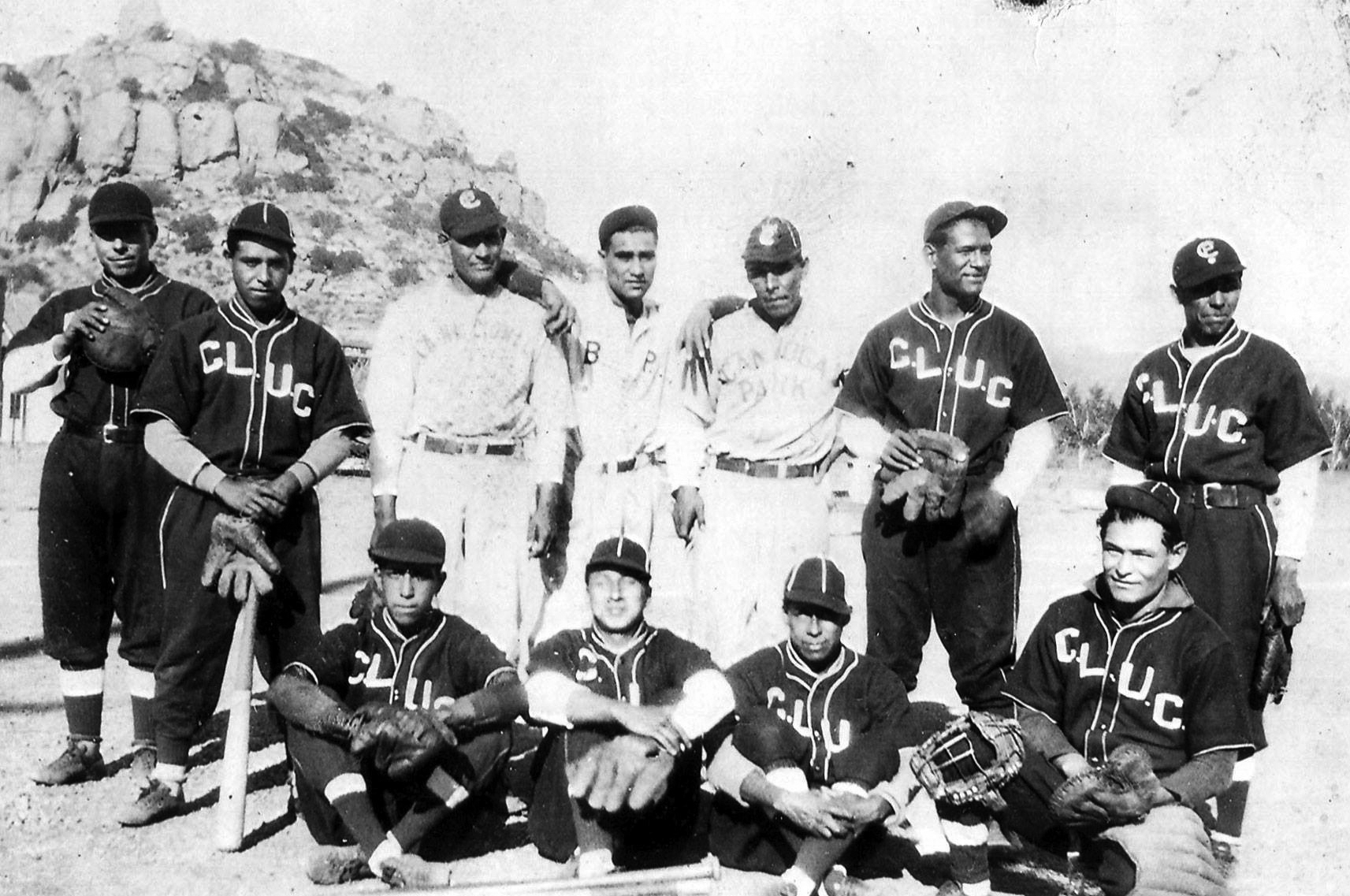
| (1930s)* – View showing a Mexican American baseball team playing out of Chatsworth. Stoney Point is seen in the background. |
Historical Notes The 1930s Chatsworth team was comprised of ranch hands who worked in the thriving San Fernando Valley citrus industry. The team seen above featured the lineup of: Jose Castaneda, second base; Bustamante, center fielder; Tellez, third base; Gonzalez, first base; Ramirez, shortstop; Parente, catcher; Jose Jimenez, left fielder; N. Ramirez, right fielder; Severiano "Babe" Valencia, pitcher and team captain. Click HERE to see more in Mexican American Baseball in the San Fernando Valley. |
* * * * * |
Freddie & Mac Filling Station
 |
|
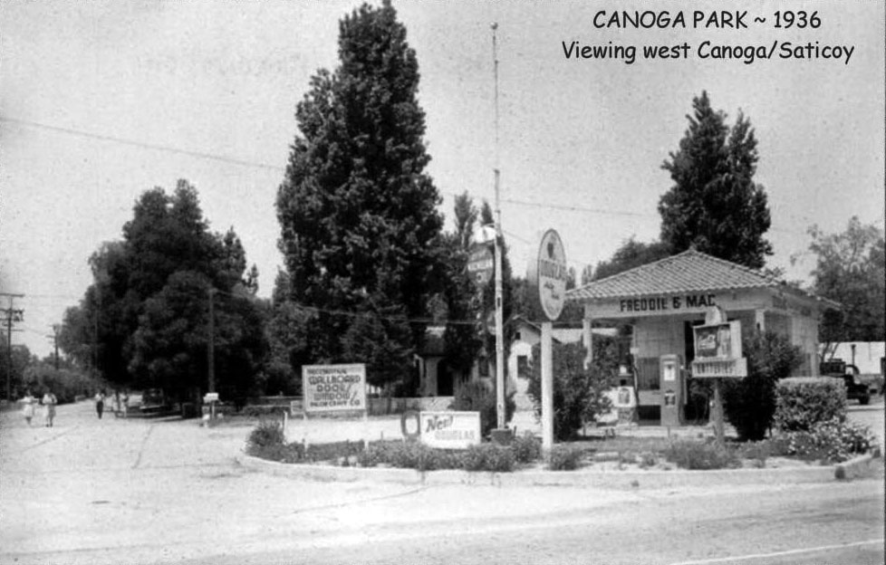
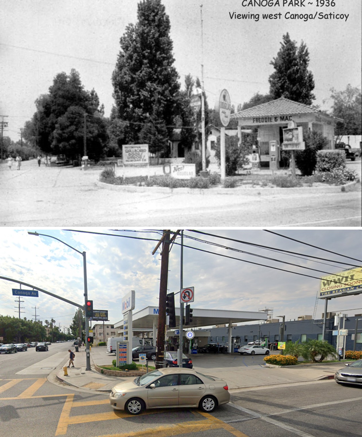
| (1936)* – View looking toward the northwest corner of Saticoy Street and Canoga Avenue showing the 'Freddie & Mac' Mobilgas station. |
Historical Notes In 1936, Canoga Park was still relatively rural and agricultural. It wasn’t until the post-WWII boom that the area saw significant suburban development. Mobilgas and Gilmore were major players in the gasoline industry, and gas stations like this were cornerstones of their local marketing. |
 |
|
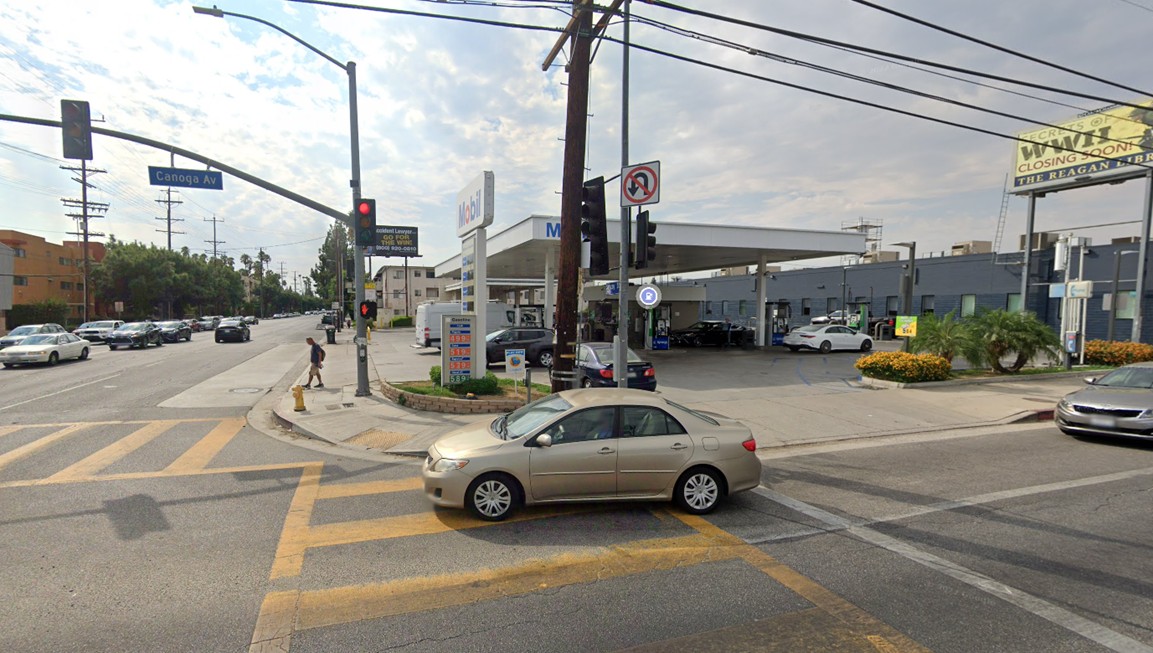
| (2022)* - Looking west on Saticoy Street at Canoga Avenue where a Mobil gas station stands on the northwest corner. |
Then and Now
 |
|
| (1936 vs. 2022)* – A ‘Then and Now’ photo comparison looking west on Saticoy Street at Canoga Avenue, where a Mobil gas station now occupies the northwest corner once home to the ‘Freddie & Mac’ Mobilgas station. |
* * * * * |
Woodland Hills Volunteer Fire Department
 |
|
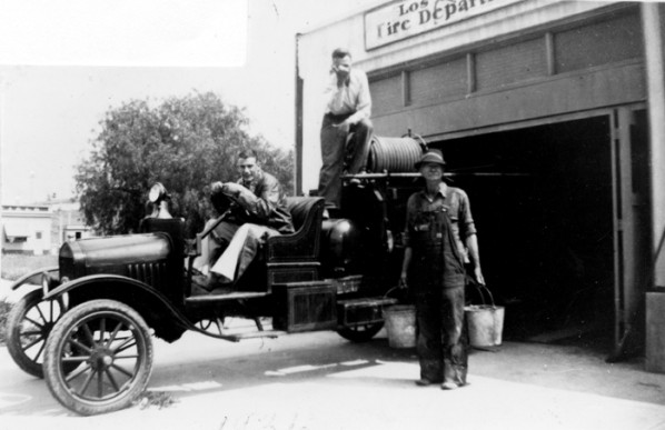
| (1936)^ - Members of the Volunteer Fire Department of Woodland Hills sitting on an engine in front of their fire house. |
* * * * * |
Los Angeles Pet Cemetery (Calabasas)
 |
|
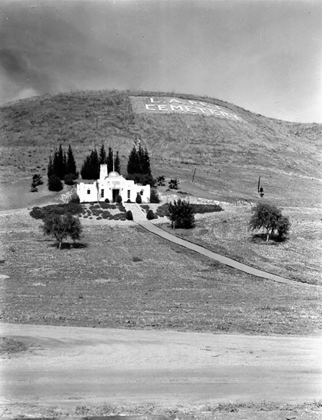
| (1939)* – View showing the Los Angeles Pet Cemetery, located at 5068 Old Scandia Lane in Calabasas. It held its first burial in 1928. |
Historical Notes The L.A. Pet Park was founded by a veterinarian to the stars named Dr. Eugene C. Jones. The cemetery, hidden among lush rolling hills and an industrial park off the Ventura Freeway, was once part of the estate of Hollywood financier Gilbert H. Beesemeyer, who embezzled $8 million from the Guaranty Building and Loan Assn. in 1929. But before his estate crumbled and he went off to begin serving a 40-year sentence at San Quentin, he subdivided his property into several 10-acre plots, one of which Jones purchased. Jones, who graduated from Washington State College with a degree in veterinary medicine in 1924, moved to Los Angeles, where he opened one of the city's first small-animal hospitals, the E.C. Jones Veterinary Hospital on Santa Monica Boulevard in West Los Angeles. As a service to his clients and as a way for them to deal with their bereavementh, Jones was intent on opening a pet cemetary. So, in 1928, heeding laws that stated no animals could be buried within city limits, he opened the Los Angeles Pet Park (in Calabasas). |
 |
|
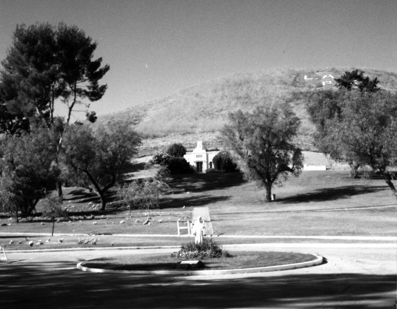
| (ca. 2013)* - View shoiwng the Los Angeles Pet Memorial Park in Calabasas. |
Historical Notes In 1973, the Jones family donated the cemetery to the Los Angeles SPCA. In 1983, the SPCA decided to sell the cemetery, which it was running at a loss. Developers, eager to snap up acreage in booming Calabasas, were opposed by a group of plot owners called SOPHIE (Save Our Pets' History in Eternity). Four years of passionate negotiations, lawsuits and fundraising followed. The tight knit community of animal lovers succeeded in raising $100,000 to buy the cemetery. They also established a perpetual care endowment to satisfy surrounding developers' concern that the property would eventually fall into disrepair. In 1986, SOPHIE officially took control of the cemetery. Today SOPHIE, which boasts about 500 members, still owns and runs the cemetery. Its famous clientele has increased over the years, with the pets of Steven Spielberg, Peter Falk, Diana Ross, Tori Spelling, Bob Barker, and William Shatner all buried there. |
* * * * * |
Topanga Canyon Summit
 |
|
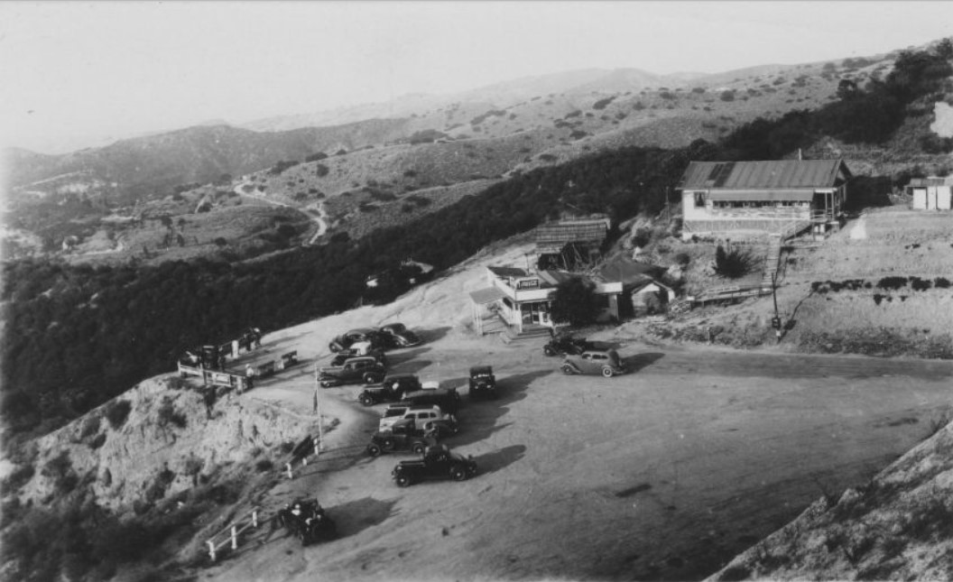
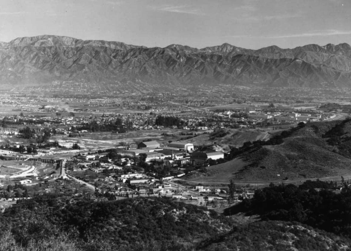
| (1942)* - View of the Summit at the top of Topanga Canyon, elevation 1560 ft. |
 |
|
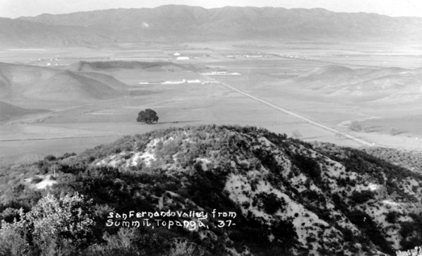
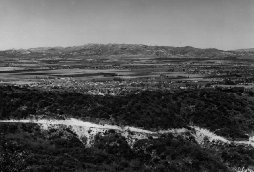
| (ca. 1937)^ - Postcard view showing the San Fernando Valley as seen from the Summit, Topanga Canyon. |
Historical Notes Click HERE to see more early views of the Topanga Canyon Summit. |
* * * * * |
Pico Court (Mission Hills)
 |
|
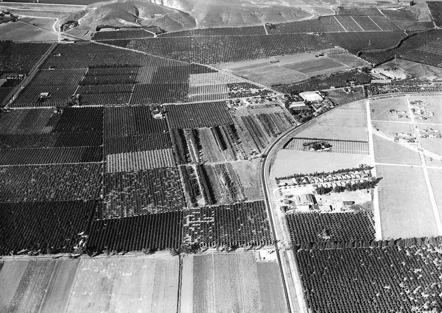
| (1935)* - Aerial view looking north showing Sepulveda Boulevard running along tracks on its left as it curves into Brand Boulevard. Pico Court is seen at center-right. Just to the north of Pico Court is a well defined plot of land on which stands the Andrés Pico Adobe. San Fernando Mission is in the upper-right. Orange and Lemon Groves can be seen throughout the area. Photo courtesy of Paul Ayers |
Historical Notes Pico Court was a small, unpaved street, running from Columbus St to Sepulveda Blvd, located just northeast of the San Fernando Heights Orange Association packing house. The land seen above was developed in 1951-53 with a large sub-division called Dennis Park coming in 1955. Shortly after there was a movement by several local residents and established businesses to change the name of the community. A vote was held on whether to officially change the name from Dennis Park to “Mission Hills”. The election held in 1956 resulted with 65% in favor of the name being changed to “Mission Hills”. The name was chosen with the “Mission” in mind. By 1959, the sign welcoming you to Dennis Park was taken down and was repainted with “Welcome to Mission Hills”. Where this sign ended up throughout the years is a mystery. That road from the upper left corner headed to the middle right was once a part of the stagecoach route from the Newhall Pass to Los Angeles. |
 |
|
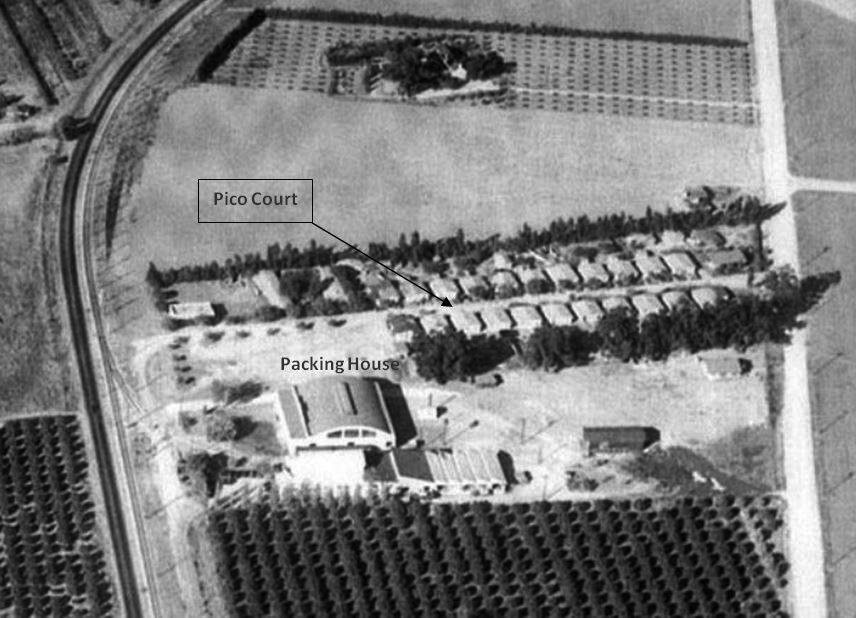
| (1935)* - Close-up view showing an upaved Pico Court running from Sepulveda Blvd (left) to Columbus Ave (right) with the Packing House seen at lower center-left. The Andrés Pico Adobe can be seen at top of photo. Photo and annotations courtesy of Keith Hart |
Historical Notes The Pacific Packing Company, which had a number of facilities throughout the southern California area, established a lemon packing plant just south of the Mission San Fernando about 1911. One article from that year detailed how the firm was poised to deliver 3,000 railroad cars of oranges and lemons from its packing houses in Riverside, Ontario, Pomona, Glendora, Orange, Fullerton, San Diego and San Fernando, among others. In 1915, however, it sold the facility to a new concern: the San Fernando Heights Lemon Association. While the use of the word “heights” is a strange one, given the generally flat terrain of the location, the association soon became a successful endeavor. Among the brand names for the fruit transferred from Pacific to the new firm were Silver Moon, Blue Moon, Evening Star, and Southern Cross. |
 |
|
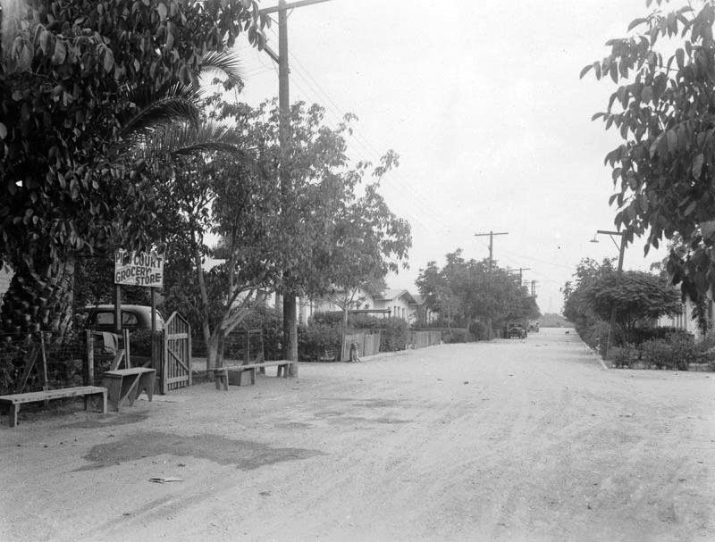
| (1930s)* – Looking down an unpaved Pico Court showing the Pico Court Grocery Store at left. Photo: LAPL |
Historical Notes In the early 1910's, Sunkist Growers built duplex houses with outdoor toilets down both sides of an unpaved Pico Court to house Mexican workers in the citrus industry. |
 |
|
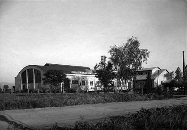
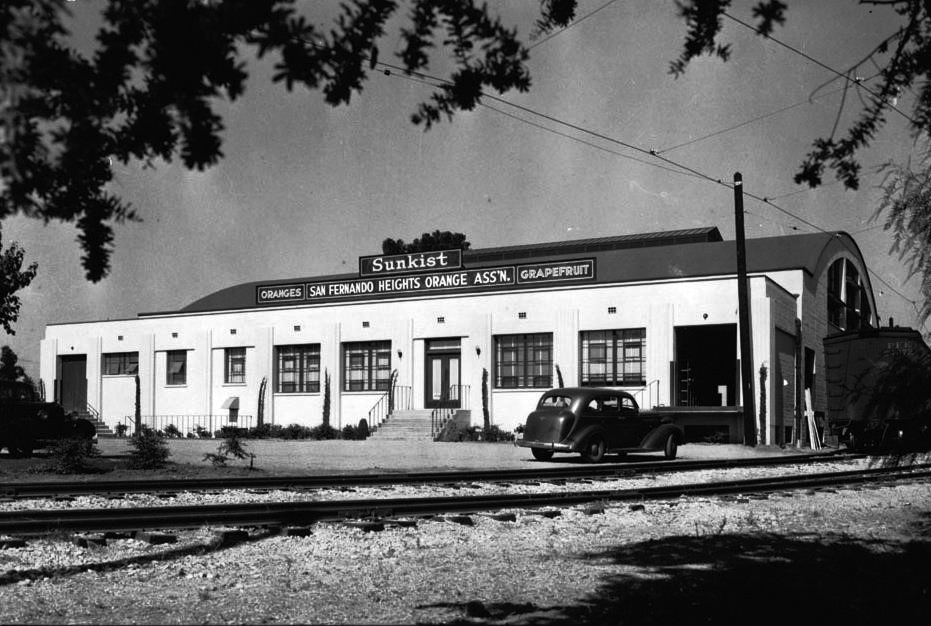
| (ca. 1938)* - View showing the San Fernando Heights Orange Association (SFHOA) packing house located on Pico Court. |
Historical Notes Times were good for this area of the valley as a population surge and economic boom fueled most industries, including citrus. In 1922, a national engineering and contracting journal reported that a new building, of one story and a basement, was being erected for the association, measuring 80 x 172′ and costing $24,000. While the Great Depression certainly affected business to a significant degree, the Sunkist facility had an additional three-story packing structure built in 1936 (seen above). |
 |
|
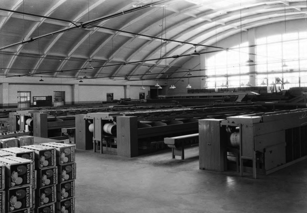
| (1936)*- Photo showing crates of citrus in a cooling room in the San Fernando Heights Orange Association packing house. Boxes labeled "Splendor" sit on their sides in stacks in the foreground on the left while others sit beneath the wooden stations at center. The stations have what resemble cylindrical spools at their ends and seem to be the cooling systems in the room. |
Historical Notes An interesting and novel idea instituted at the plant came in 1936, when management decided to use a wide palette of paint colors. Orange-packing machinery was painted violet, grading tables became mustard yellow, conveyor belts sported a shade of peacock blue and the women who constituted a majority of plant workers wore two-tone tan uniforms with orange piping. One newspaper article quoted an employee as saying, “We love it!” while another enthused “and we don’t get so tired.” |
 |
|
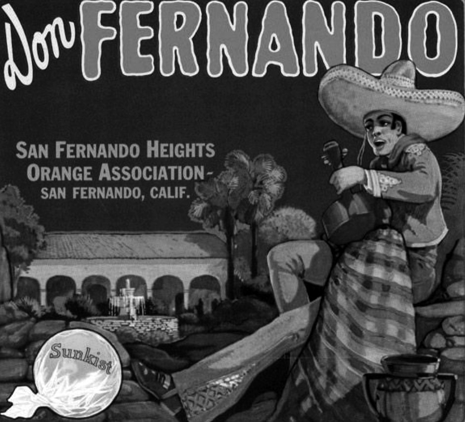
| (1930s)* - Sunkist orange crate label: “Don Fernando – San Fernando Heights Orange Association”. |
Historical Notes As the mania for collectibles grew in the years after the plant’s closure, one of the ways in which citrus farming had a continuing visual presence was in the collectibility of packing crate labels. Mounted on the two long ends of a wood crate which carried cirtus fruits, these labels became increasingly more colorful and romantic, taking advantage of the “mission” theme for both product names and imagery. |
 |
|
| (ca. 1938)* – Close-up view showing the Sunkist Packing Plant from a different angel with tracks in the foreground and railcar on the right. The parked car appears to be a 1937 Chevy. |
Historical Notes The citrus industry in the Valley hit its peak in the 1930s. By the end of World War II, the housing boom began to squeeze out the orange groves. New homeowners, while fond of the fragrant scent of the orange blossoms, did not appreciate the manure and tractors that went along with the groves. As a result of infringing development, yields declined while the farmland became more valuable as residential housing. |
 |
|
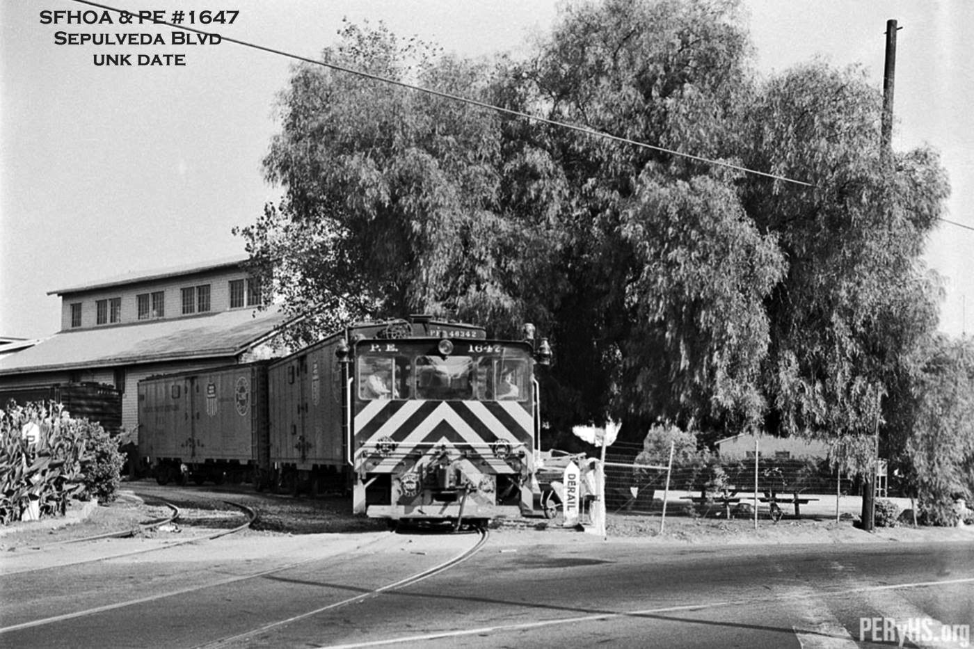
| (ca. 1950s)* - Photo captioned reads: "Pacific Electric freight diesel unit no. 1647 pulls away from the San Fernando Heights Orange Association on Sepulveda Blvd. in the San Fernando Valley." [Bill Whyte Photo, Steve Crise Collection] Photo courtesy of Rich Krugel and PacificElectric.org. |
Historical Notes After World War II huge numbers of new residents to the greater Los Angeles region transformed suburban areas such as the San Fernando Valley. In 1948, the San Fernando Lemon Association, a nearby facility, closed its doors in the face of declining acreage of lemon groves and the resulting effect on production. Still, at the end of the year, a news report observed that the San Fernando Heights plant had 8o workers processing fruit picked by 100 field hands in the association’s fields. |
 |
|
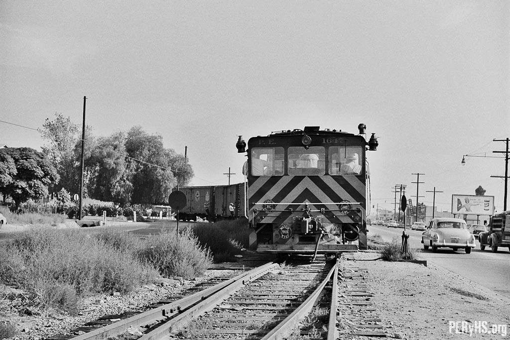
| (1950s)* - Pacific Electric freight diesel unit no. 1647 pulls away from the San Fernando Heights Orange Association on Sepulveda Boulevard headed for San Fernando. [Bill Whyte Photo, Steve Crise Collection] Photo courtesy of Paul Ayers and PacificElectric.org. |
Historical Notes Citrus had become the second largest industry in California — just behind oil — right up until the late 1930s. But by the 1950s, what was once the “citrus belt” of Southern California was plowed and paved. In 1956, the name of the community surrounding Sepulveda and Brand was changed to Mission Hills. |
Then and Now
 |
|
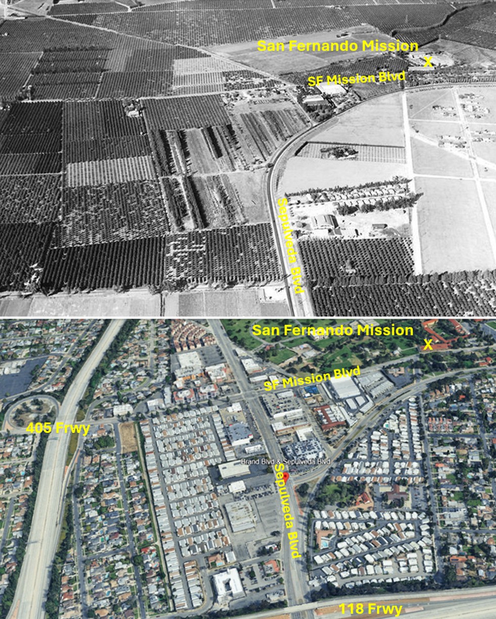
| (1935 vs. 2023)* – a ‘Then and Now’ aerial photo comparison of the San Fernando Mission and its surroundings in Mission Hills. Photo comparison by Jack Feldman. |
* * * * * |
Granada Hills
 |
|
| (1920s)* – Panoramic view of Sunshine Ranch (now Granada Hills) facing southeast at the corner of Rinaldi St. and Shoshone Ave. The large two story house no longer is there, but the three houses facing Shoshone are still standing. |
Historical Notes In 1916, the San Fernando Valley's first oil well was drilled in what is now Granada Hills. The oil well was located at the northern tip of Zelzah Avenue. In 1917, Oklahoman oil magnate J. H. Mosier purchased 4100 acres of the Porter Ranch from George K. Porter and renamed it Sunshine Ranch. Between 1917 and 1924 over 2000 acres of the ranch were planted with citrus trees. In 1925 the land was sold to Suburban Estates, Inc. and shortly thereafter they subdivided the real estate into residential and commercial lots. The first home and commercial building was built in 1926. At this time the area was still known as Sunshine Ranch. |
 |
|
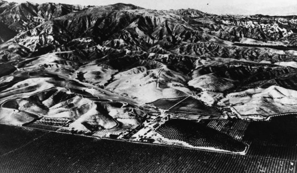
| (ca. 1932)^ - Panoramic view of Sunshine Ranch in Granada facing north, with the Santa Susana Mountains in the background. The citrus trees are on the south side of Rinaldi Boulevard. |
Historical Notes Granada Hills was founded in 1927 (as "Granada;" the "Hills" was added 15 years later) and started out as a dairy farm and orchard known as the Sunshine Ranch. It was named after a town in Spain that has a very similar climate and topography to the north San Fernando Valley. |
 |
|
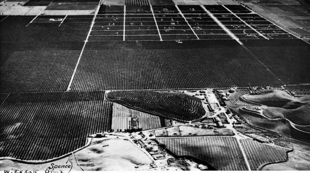
| (ca. 1932)^ - Spence air photo of Sunshine Ranch facing south showing the citrus trees, mostly on the south side of Rinaldi. The arrow in the lower left points to the Wickson Grove. |
Historical Notes According to a 1938 Los Angeles Times article a large number of citrus groves were sold around Granada between 1935 and 1938. The Granada Orange Estates development included 400 acres of orange, lemon and grapefruit groves, and the "Granada townsite itself" included another "867 orange sites." A 1936 tract lot shows that the Granada Orange Estates was bounded approximately by Balboa to the east, San Jose to the south, Zelzah to the west, and Rinaldi to the north, which places it in area of Los Angeles currently known as Granada Hills. Among the crops harvested in Granada Hills were apricots, oranges, walnuts and beans. Vestiges of former citrus groves can still be seen as small groups of orange, lemon or grapefruit trees in some residential yards. |
 |
|
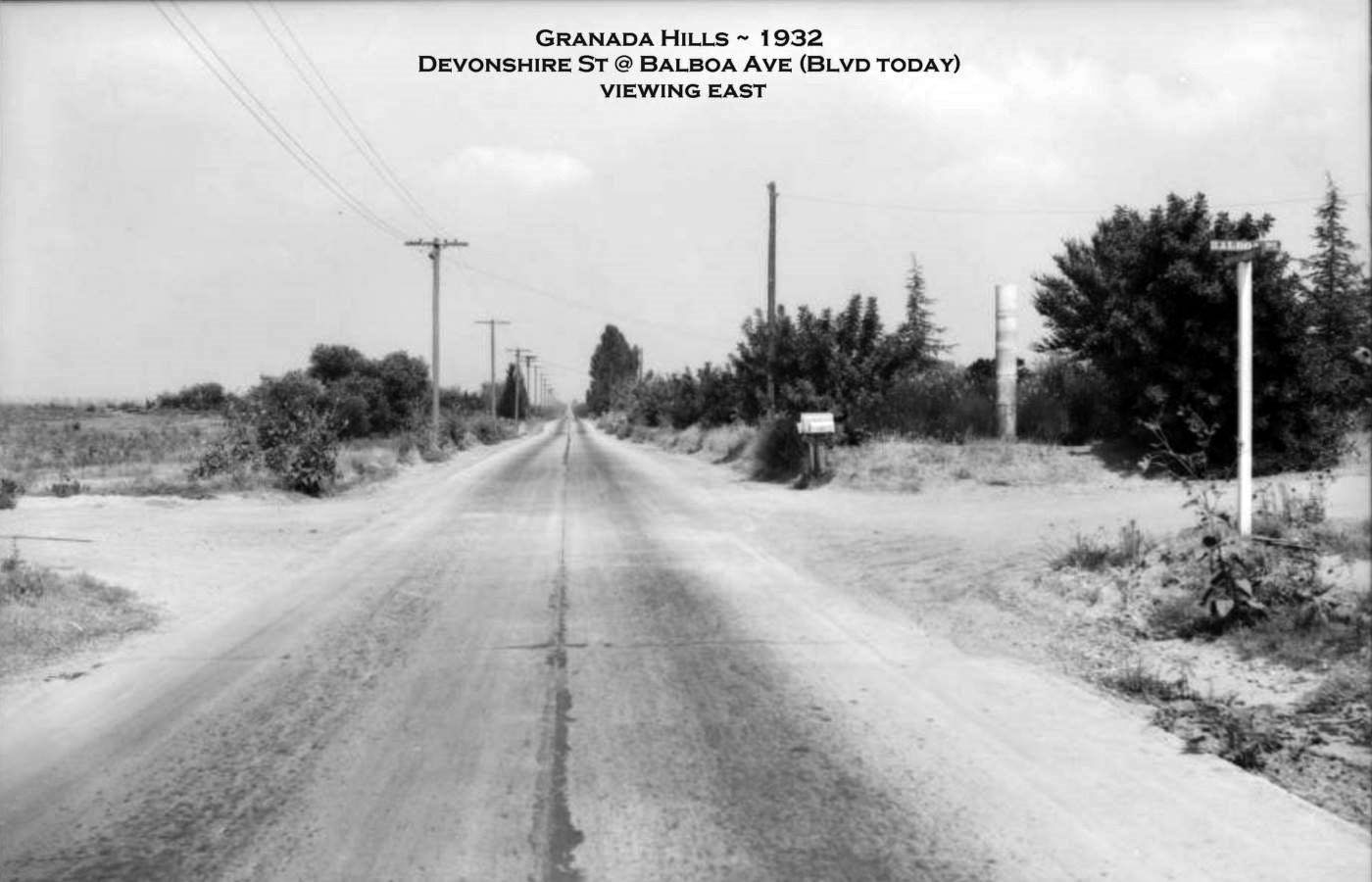
| (ca. 1932)* - View looking east on Devonshire Street at Balboa Ave (Blvd today). The street sign can be seen on the right. |
Then and Now
 |
|
| (1932 vs. 2018)* - View looking east on Devonshire Street at Balboa Ave (Blvd today). Photo comparison by Jack Feldman. |
 |
|
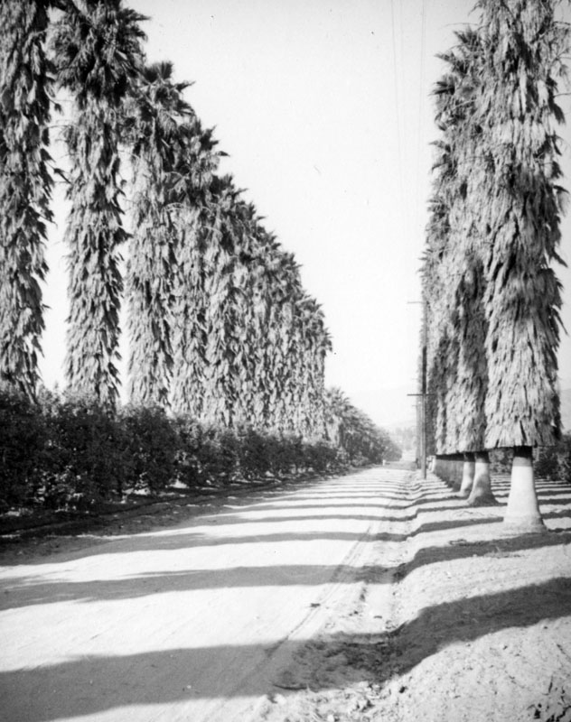
| (ca. 1937)* - Palms line the road between citrus groves in Granada Hills. Photo by Herman Schultheis. |
 |
|
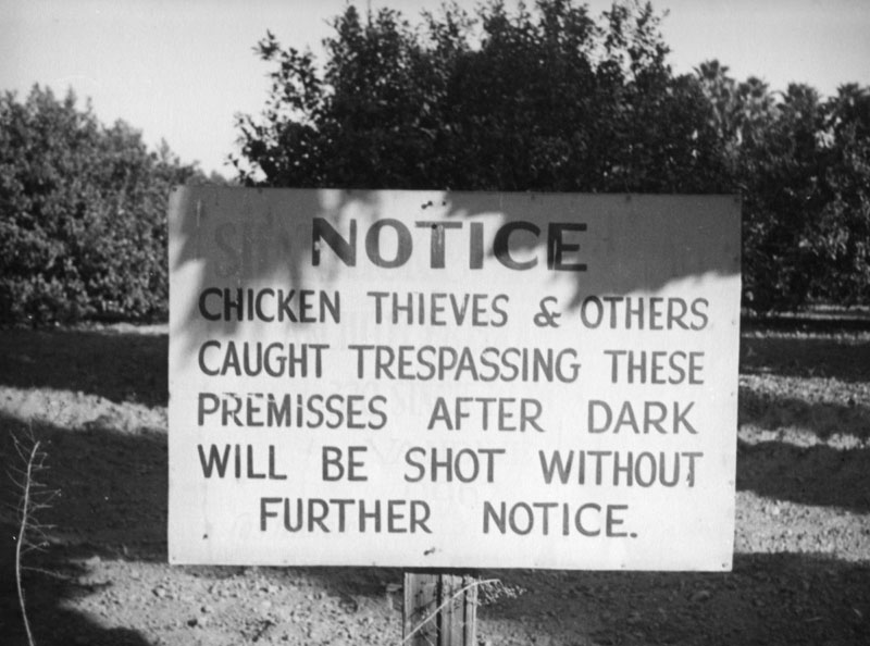
| (ca. 1937)* - A sign that says "chicken thieves and others caught trespassing these premises after dark will be shot without further notice" is posted in front of an orange grove in what is now known as Granada Hills. Photo by Herman Schultheis. |
 |
|
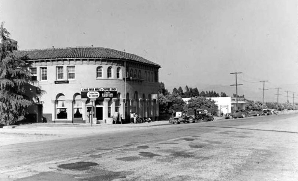
| (ca. 1930s)^ - View of the Granada Building, built in the 1930s, at the corner of White Oak Avenue and Chatsworth Street. |
Historical Notes The Char-Mar Malt and Coffee Shop was an early occupant of this Spanish-style building. It was also used as a community meeting center. The offices of California Trust Co., responsible for the sale of much of the land that makes up present-day Granada Hills, were located here as well. It is now a one story building. Suburban Estates, Inc., went into receivership in 1932 and was taken over by the California Trust Co., which had furnished much of the money for the development of the community. This company set up offices in the corner store of the Granada Building, operating there until all the lots were sold in 1940. |
 |
|
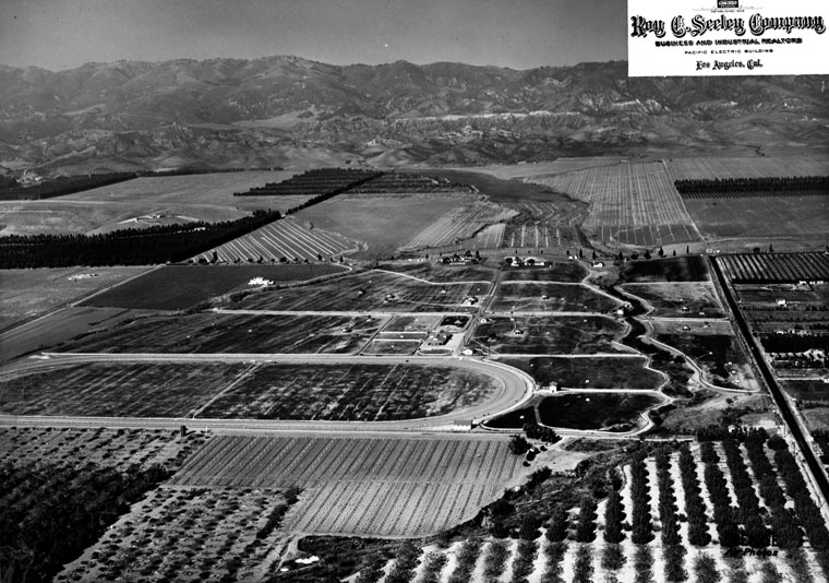
| (1940)* - Aerial view showing Granada Hills in the northern end of the San Fernando Valley. The two main streets running diagonally from bottom to center of photo are Zelzah (left) and Louise (right). Chatsworth Street runs from east to west across the center of photo. The race track at Devonshire Downs can be seen at lower-left on the corner of Zelzah and Devonshire. Crop fields can be seen throughout. |
Historical Notes Because of it’s remote location in the 1920’s, the number of residential homes did not start to increase until the 1940’s. Actor James Cagney owned the “Cagney Ranch” in the 1940s, nestled in the hills north of Rinaldi, west of Balboa. In May, 1942 the name of the community was changed to Granada Hills, so as not to conflict with Grenada, California, and the Granada Hills branch post office was opened. |
 |
|
| (ca 1940s)* – View of Rancho Oro Grand (aka Bull Canyon Meadows, aka Cagney Ranch) located in Granada Hills above Rinaldi between Zelzah and Balboa. Photographed by Alvin Kleeb of Granada Hills in the early 1940s from the top of old Shoshone Street. |
Historical Notes The construction of “Rancho Oro Grande” began in 1939 and was completed in 1940. Mr. Wells of the Layne-Wells Corp. in Los Angeles built the ranch and used it as a Thoroughbred Stud farm, which included two stallions and about thirty brood mares. There were also nearly 400 head of beef cattle on the ranch as well. Shortly after the outbreak of World War II, Mr. Wells sold the ranch to Gilbert Adrian, the clothes designer from MGM, and his wife Janet Gaynor, the actress from 20th Century Fox. Mr. Adrian and Ms. Gaynor continued to use the ranch for horses and called it “Rancho Oro Grande”. The ranch at this time was about 800 acres in size. |
 |
|
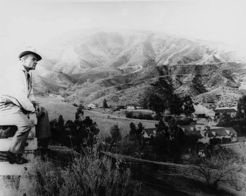
| (1956)^ – View of James Cagney looking down at his ranch located at 17801 Bull Canyon Road in Granada Hills. Photographed by Flyod McCarthy from the main entrance which is at the present day intersection of Louise and Rushing Drive. |
Historical Notes In 1953, James Cagney and wife, Frances Vernon, bought 450 acres of the ranch from Actress Janet Gaynor and husband, Gilbert Adrian, and later purchased a 90 acre orange grove that fronted old Balboa Blvd. The orange grove purchase gave the Cagney’s easier access to the ranch because the original entrance on old Shoshone Ave was a very narrow winding road. During the Cagney’s tenure the ranch was called “Bull Canyon Meadows”. The Cagney's used the ranch strictly for raising horses. Among some of the horses boarded there were trotters, pacers, and some of the purest bred Morgans in the country. Although the Cagneys loved the ranch, they did not like the encroachment of housing developers; therefore they decided to sell it. The Cagneys sold the ranch around 1964. The new owner was James Roache and he named the ranch the Triple –A Ranch. It was at about 500 acres at the time. Parts of the ranch were subsequently sold (1970s) leaving only 150 acres. In the late 1980s the last remaining 150 acres were sold to developers. The main stable and foal barn were torn down during the summer of 1988 when the land was developed for houses. Today, the main house is all that is left of the ranch. |
 |
|
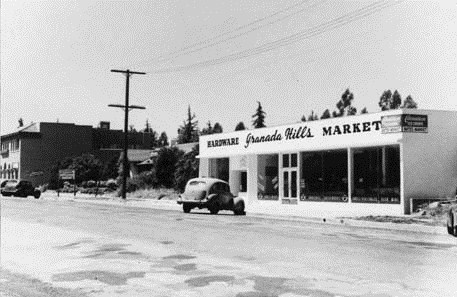
| (1946)^ - The Bates Market building, located on Chatsworth Street, 1946. Also known as the Granada Hills Market, it served as a hardware store as well. |
Historical Notes Chatsworth Street - The western portion used to be known as Ben Porter Avenue, for the owner of the rancho across whose land the road passed. For a time, the portion near Zelzah Ave. was named Santa Susana Pass Road. |
 |
|
| (ca. 1940s)^ - View looking east on Chatsworth Street where Zelzah Avenue curves into it. |
 |
|
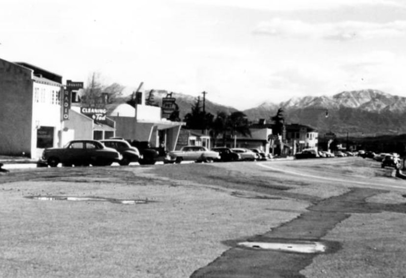
| (1965)* – View looking east on Chatsworth Street from Zelzah Avenue during the holidays. |
 |
|
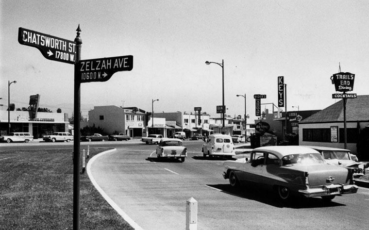
| (1961)* - View looking northeast at the curved corner of Zelzah Avenue and Chatsworth Street in Granada Hills. |
 |
|
| (2017)* - "Welcome to Granada Hills" monument in Veterans Triangle at Zelzah and Chatsworth with the Memorial Walkway seen at right. |
Historical Notes Installed four decades ago after the Vietnam War, the Granada Hills Veteran’s Park (Zelzah and Chatsworth) is maintained by the Granada Hills Rotary Foundation. It was last refurbished in 2009 and 2010. |
* * * * * |
Dale's Market
 |
|
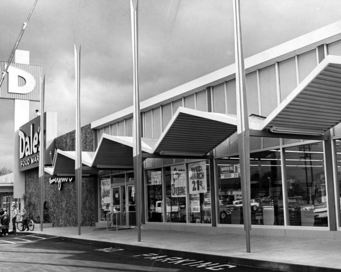
| (1962)* - Photograph article dated March 20, 1962 partially reads, "The newly - completed Dale's Food Mart situated in the $750,000 Devon-Wood Shopping Center, Devonshire Blvd. and Woodley Ave., Granada Hills, is scheduled to open Wednesday." Valley Times |
Historical Notes Over time the above building has been modified and today is occupied by Smart and Final. Click HERE for contemporary view. |
* * * * * |
Balboa Highlands
 |
|
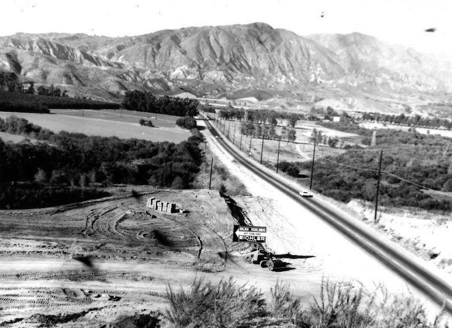
| (1963)* – View looking north on Balboa Boulevard at Lisette Street with the Sylmar Mountains in the distance (Woodley would later connect on the right). Sign in the foreground (NW corner of Balboa and Lisette) reads: Balboa Highlands – Left Turn Here – Eichler Homes |
Historical Notes Balboa Boulevard was re-routed to make room for the MWD Jensen Water Treatment Plant (completed in 1972). |
 |
|
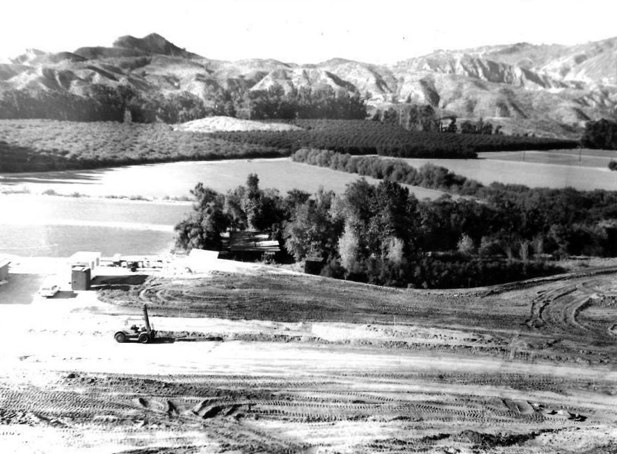
| (1963)* – Balboa Highlands construction site for the Eichler Tract. In the distance can be seen Mission Peak. Also the location of Sunshine Canyon landfill. |
Historical Notes The Balboa Highlands tract, located in Granada Hills, is one of the northernmost enclaves in the San Fernando Valley. The area is characterized by its rolling hills; the early Spanish missionaries referred to it as “La Encantada Cuestas,” or the Enchanted Hills. |
 |
|
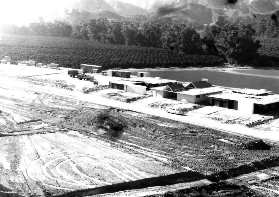
| (1963)* – View showing construction of new homes on the 17000 block of Lisette Street. This was part of the Balboa Highlands development in Granada Hills (aka Eichler Tract). Click HERE to see a contemporary view of the A frame house at center-right. |
Historical Notes This neighborhood of roughly 100 homes was built by renowned developer, Joseph Eichler between 1963 and 1964 and is located at the northern edge of the San Fernando Valley. It is the only Eichler tract in Los Angeles County. The tract consists of 4 main streets: Darla Avenue, Lisette Street, Nanette Street, and Jimeno Avenue, off Balboa Blvd. in Granada Hills. The site planners and principle architects were A Quincy Jones and Frederick Emmons. |
 |
|
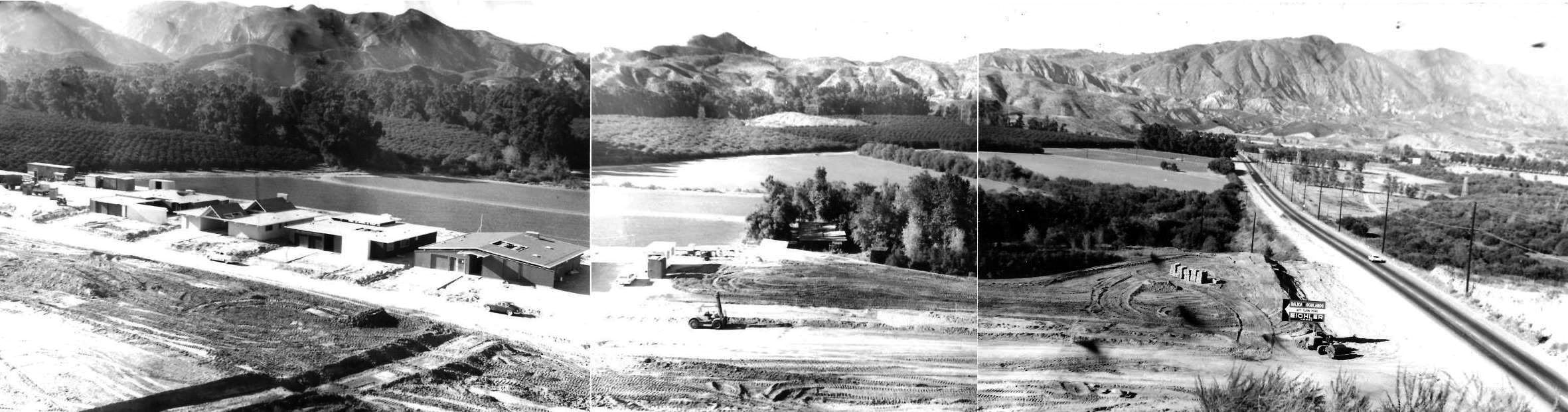
| (1963)* – Panoramic composite view showing the new Balboa Highlands development in Granada Hills. |
Historical Notes A 1963 real estate advertisement for Joseph Eichler’s Balboa Highlands tract instructs prospective buyers to take the “Ventura Freeway to Balboa then north eight miles to models.” A year and a half later, a similar ad suggests drivers take the San Diego Freeway to the Rinaldi exit. In less than a decade, the San Fernando Valley went from relative isolation from other parts of the City of Los Angeles to being serviced by four interstate highways. The first major interstate to make its way into the San Fernando Valley appears to have been the Ventura Freeway (U.S. 101) in the late 1950s; the Golden State Freeway (Interstate 5) came through the Sepulveda Pass soon after, and the San Diego Freeway (Interstate 405) opened in 1962. The last to open appears to have been the Foothill Freeway (Interstate 210), which opened in the mid-1960s. To be sure, Eichler chose Granada Hills for his new tract at least in part due to its location convenient to several new freeways. In a promotional brochure, he described the tract’s situation as follows: “Located on beautiful rolling land in the San Fernando Valley, Balboa Highlands is well situated to an exceptional variety of educational, recreational, shopping and freeway facilities.” |
* * * * * |
 |
|
| (ca. 1937)* - Exterior view of an adobe in the San Fernando Valley in the 16000 block of Victory Blvd. in present-day Van Nuys. It was built circa 1911 by Frank P. Ghiglia as a house for ranch hands. |
Historical Notes Victory Boulevard was named in honor of the Valley's World War I veterans in 1924. The segment west of Balboa Boulevard did not open until 1955. |
 |
|
| (1930s)*^^ - Tract housing stretches into the horizon on Oxnard Street, North Hollywood. |
Historical Notes in 1927, in an effort to capitalize on the glamour and proximity of Hollywood, Lankershim was renamed "North Hollywood". The result was a massive development of housing which transformed the area into a suburban development of Los Angeles.*^ Oxnard Street was named for Henry T. Oxnard, sugar beet magnate in the Ventura County area. The name dates from 1916, when the Valley was developing into a major beet producer. |
 |
|
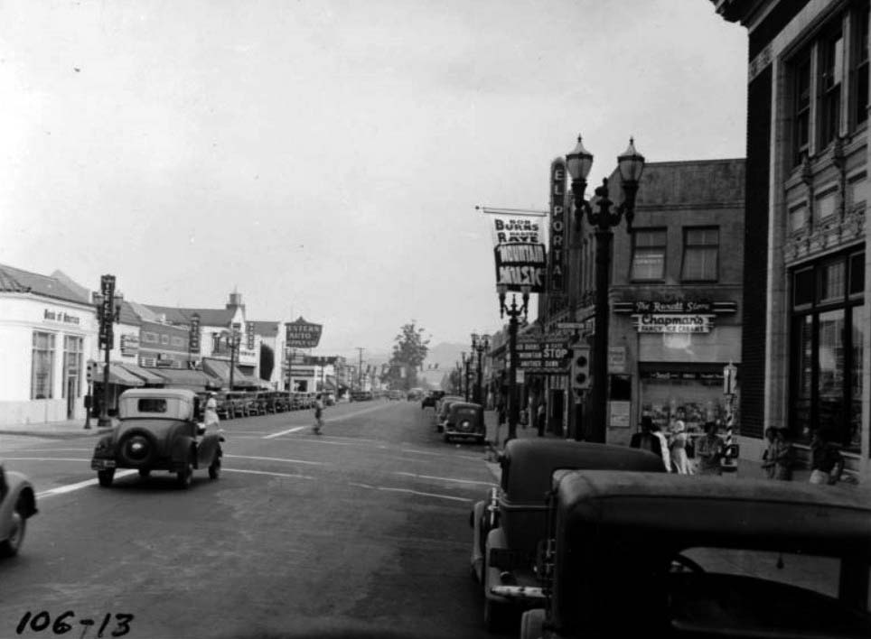
| (1937)^^ - View looking south on Lankershim Boulevard in North Hollywood. The El Portal Theatre, located at 5269 Lankershim Boulevard, appears at center-right. |
Panorama City (Regan Studios)
 |
|
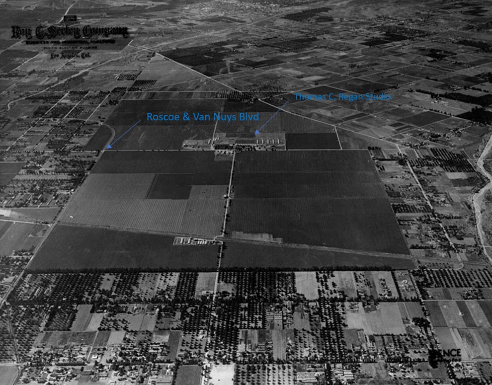
| (1937)* - Aerial view of the San Fernando Valley north of Panorama Ranch. Top center of photo is near the intersection of Roscoe and Ventura Canyon Ave…near where Kaiser Panorama City is located today. Roscoe & Van Nuys Blved is at top-left center. Diagonal line at lower-center is where the railroad tracks run. Also identified above is the location of the short-lived Thomas C. Regan Studios at 13553 Reedley St. |
Historical Notes Panorama City was developed as a planned community by industrialist Henry J. Kaiser. Contrary to popular perceptions of the development of the central and western San Fernando Valley as solely being a bedroom community for jobs in downtown Los Angeles and Burbank, Panorama City originally included General Motors' largest assembly plant to date, as well as a Schlitz brewery that eventually came under the ownership of Anheuser-Busch.* Henry John Kaiser (May 9, 1882 – August 24, 1967) was an American industrialist who became known as the father of modern American shipbuilding. He established the Kaiser Shipyard which built Liberty ships during World War II, after which he formed Kaiser Aluminum and Kaiser Steel. Kaiser organized Kaiser Permanente health care for his workers and their families. Kaiser was involved in building civic centers, roads, and schools. He was part of the consortium that constructed the Hoover Dam and Grand Coulee Dam. Kaiser is also noted for advancing medicine with the development and construction of several hospitals, medical centers and medical schools. His mining town of Eagle Mountain, California, part of the West Coast's first integrated mining/processing operation linked by rail to his mill in Fontana, California, was the birthplace of Kaiser Permanente, the first health maintenance organization.* |
 |
|
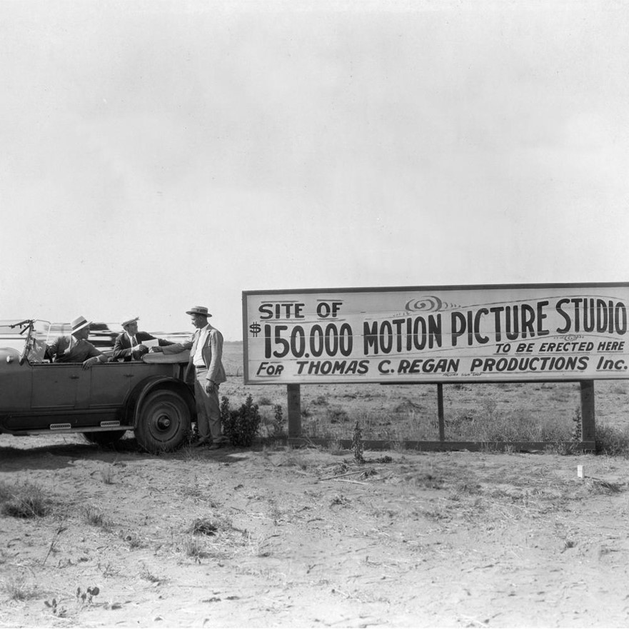
| (ca. 1925)* - Site of $150,000 Motion Picture Studio 'to be erected here' for Thomas C. Regan Productions Inc., located in what is today Panorama City (see previous aerial photo for location). |
Historical Notes Hollywood historian Robert Birchard didn’t know how deep he would dig when he found a little wooden box for sale at a Las Vegas antique store. Inside were pictures of the “Thos. C. Regan Productions Co.” and the silent film buff was determined to learn what had happened to the forgotten movie studio. The mementos inside once belonged to Regan himself, a con artist who sold non-existent stock, wooed women to fund his pictures and talked a friend into writing a check when a load of lumber arrived that was to become his studio. Birchard unearthed more than just the story of a cool old building, he got a silent-era Chinatown with a hack filmmaker supported by the Los Angeles Times and touching everyone from valley booster clubs to Rudolph Valentino. ”What are the odds,” he thought “that a lost silent movie studio built by a non-existent company, that apparently never released a film, might survive more than eighty years after it was built?” * |
 |
|
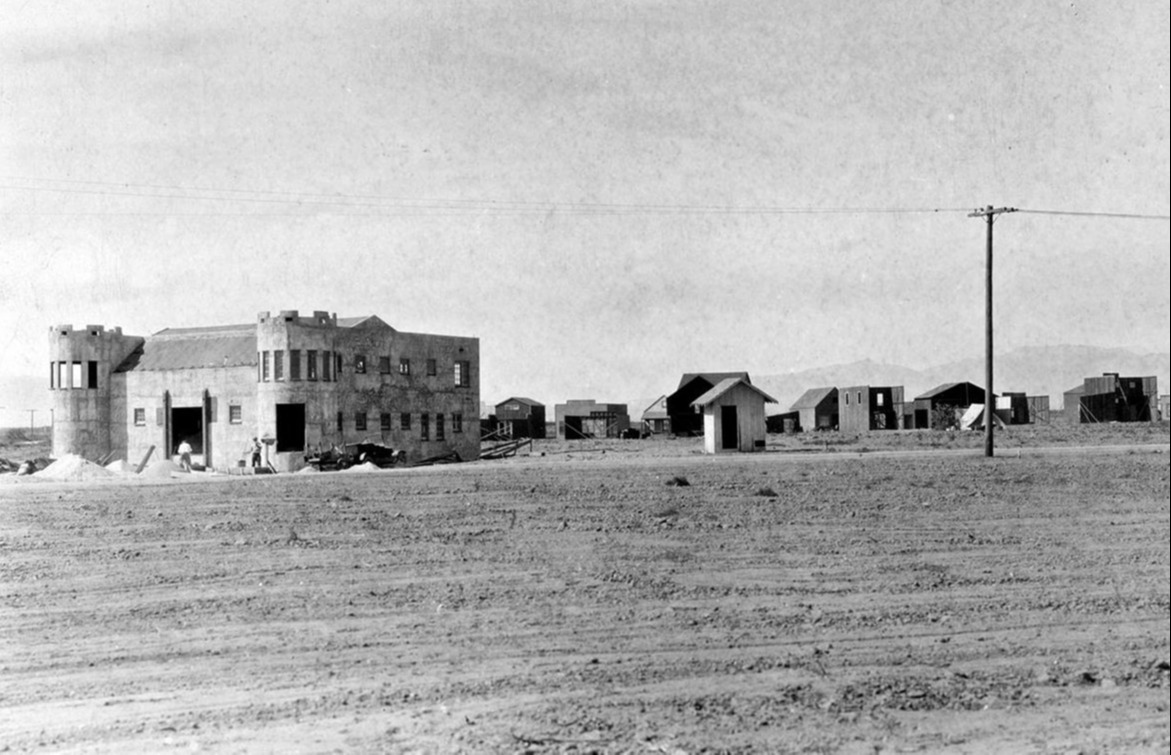
| (1926)* – Construction site of the Thomas C. Regan Studio complex. The castle-like structure seen above is the administration building. |
Historical Notes ”What are the odds that a lost silent movie studio built by a non-existent company, that apparently never released a film, might survive more than ninety years after it was built?” Birchard’s odyssey into the life of the forgotten cowboy unfolds in Pop Twenty, a slick journal of Hollywood obscura and mid-century pop culture. As for the California Crazy-style castle Regan built, it survives today as an American Legion Hall in Panorama City. The legionnaires, who thought their castle was once a house of ill repute, got a much more interesting story and Birchard discovered a lost piece of L.A. history. |
Then and Now
 |
|
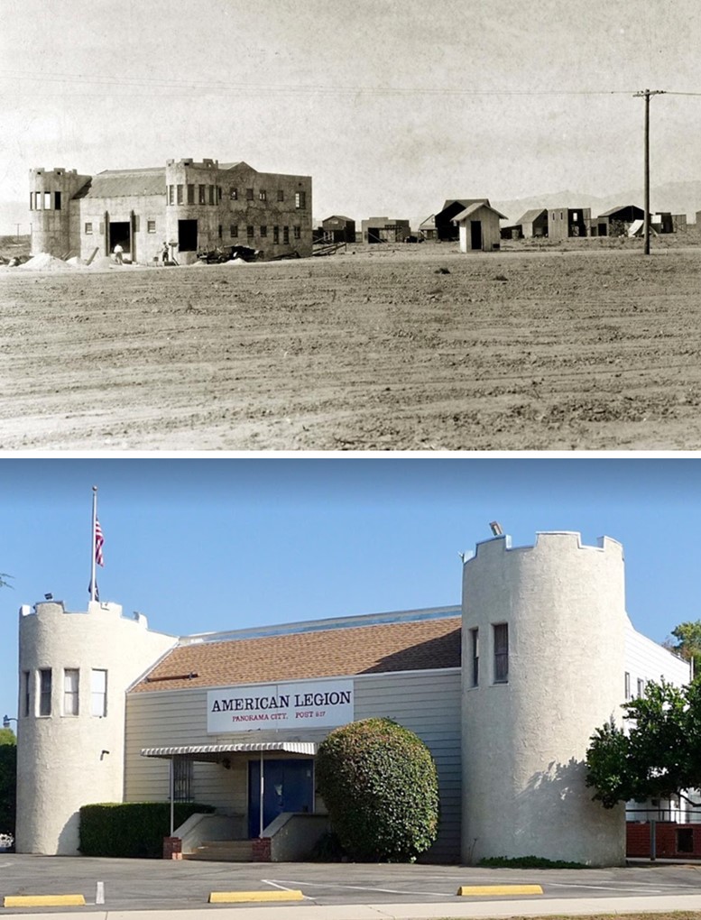
| Then and Now - Regan Studios in 1925 and, today, the American Legion Post 817 in Panorama City - 13553 Reedley Street. |
Historical Notes According to film historian Robert "Bob" Birchard, American Legion Post 817 located at 13553 Reedley St., Panorama City, CA 91402, was originally built in 1926 as the administration building for the Thomas C. Regan Studio. The architect was H.B. Pentland of Van Nuys. The castle like structure was part of a silent motion picture studio that, alas, never released any commercially-made films, which of course, begs the question: was the company's films so bad that they could not find distribution, did the company make non-commercial films or did the company run out of money before it could even take off as a business? Typical of many Los Angeles area buildings, there are alternative histories steeped more in folklore than in documented fact. In the following article from the Los Angeles Times in 1999, the history of the building might have had a colorful past apart from its silent film connection. Click HERE to read more. |
Marwyck Ranch
 |
|
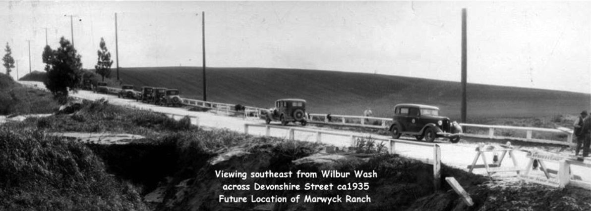
| (ca. 1935)#^*^ – Panoramic view looking southeast from Wilbur Wash across Devonshire Street. This is the future location of the Marwyck Ranch. |
Historical Notes The above photo was taken by a camera located on the now property of Little League. Over this hill would be the intersection of Devonshire and Reseda . Down to the right of that "hill" would be where the horse racing/training track was , later paralleled by Lassen . |
 |
|
| (1940)^ - View looking east on Devonshire Street between Wilbur and Reseda. The Marwyck Ranch house was located at the crest of the hill south of Devonshire (to the right). |
 |
|
| (1939)^**# - Aerial view showing the Porter Ranch/North Valley section of the San Fernando Valley. The intersection of Devonshire and Reseda is seen lower right-center with the Marwyck Ranch and track at center-bottom. The Wilbur Wash can also be seen as it crosses Devonshire and heads south towards the west end of the track. |
 |
|
| (ca. 1937)* - Aerial view of the San Fernando Valley looking north at what is now Northridge. Most of the land seen is part of the Marwyck Ranch, owned by Barbara Stanwyck and Zeppo Marx. The intersection of Reseda and Devonshire is in the upper center-right. Devonshire is the tree-lined street running left to right. Both the Stanwyck and Marx homes can be seen on the south side of Devonshire (center of photo). |
Historical Notes Both Barbara Stanwyck and her agent Zeppo Marx with wife Marion each purchased 10 acres on Devonshire Street high on a knoll at the northern edge of the ranch from silent star Janet Gaynor. Both built formidable, large, rambling ranch style homes that overlooked the breeding facility and farmland.^**# “Marwyck” is a combination of the owner’s last names (Marx/Stanwyck). |
 |
|
| (ca. 1937)^**# – Aerial view looking north, with a closer look at the horse track on the Marwyck Ranch. The Marxs and Stanwyck Estates can be seen at top-center just south of the tree-lined street (Devonshire). Lassen Street runs along the southern edge of the track. |
Historical Notes Marwyck Ranch spread from the southern edge of the residences, along Reseda Boulevard, to what is now Lassen Street where the 6 furlong (¾ mile) training track was located. Just south beyond the track was the famous Huntsinger Turkey Farm.*^ |
 |
|
| (ca. 1937)^**# – View looking north showing the estates of Zeppo Marks (right) and Barbara Stanwyck (left). Devonshire is the tree-lined street that runs across the center of the photo. |
Historical Notes In 1939, Barbara Stanwyck married actor Robert Taylor. In 1940, she then sold her Robert Finkelhor designed home on 10 acres to actor Jack Oakie. Oakie resided in the property for decades along with his wife Victoria Horne Oakie. At that same time Stanwyck also sold her share in Marwyck Ranch to Zeppo Marx who retained ownership of Marwyck until 1943. At that time, Marwyck Ranch was sold to John H. Ryan who renamed it Northridge Farms. Ryan continued to breed and train champion thoroughbred race horses. By this time, Northridge was known as the "Horse Capital of the West," with regular Sunday horse shows, annual stampedes, and country fairs. In 1956, Ryan held a Dispersal Sale selling horses, track, supplies and land. By the mid 1960’s land developers began subdividing the ranch and constructing residences.^**# |
 |
|
| (1937)^*#* - Devonshire looking east toward Reseda Blvd. Barbara Stanwyck's Estate, at 18650 Devonshire Street, is in the foreground and Zeppo Marx's in the upper corner. |
Historical Notes In 1990, the property and home at 18650 Devonshire St. were designated LA Historic-Cultural Monument No. 484 (Click HERE to see complete listing). |
 |
|
| (1937)* - Barbara Stanwyck walking by pool at her Marwyck Ranch. View is looking south showing the vast open land of the San Fernando Valley. CSUN is there now. |
 |
|
| (ca. 1937)^ - Barbara Stanwyck at the Marwyck Ranch that she built in 1937 with architect Paul Williams. Oakridge Estate Northrige, Ca. |
* * * * * |
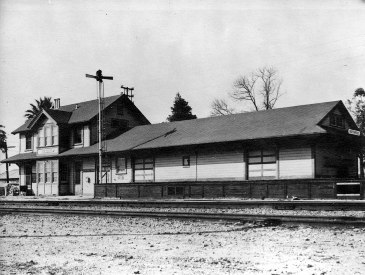
Zelzah Train Station (Renamed North Los Angeles Train Staion and then Northridge Train Station)
 |
|
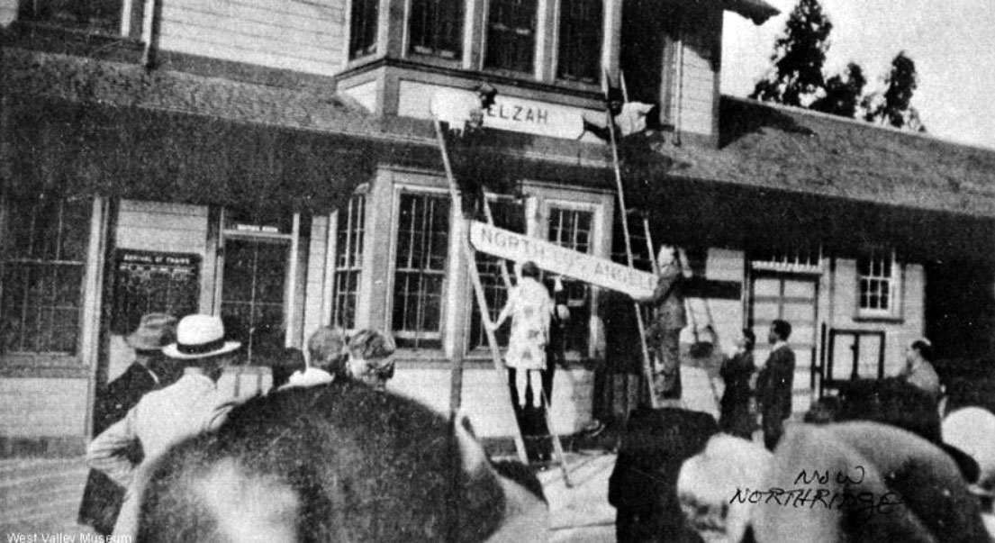
| (1929)* - View of the Zelzah Train Station showing several people on ladders in the process of replacing the “ZELZAH” sign with one that reads “NORTH LOS ANGELES”. |
Historical Notes The Zelzah Train Station, also known as the Zelzah Depot, was a train station built in 1910 by the Southern Pacific Railroad in the area now known as Northridge. It was located at the northwest corner of present-day Parthenia Avenue and Reseda Boulevard. The station was named after the biblical name "Zelzah," which means "oasis," referring to a water well located across the street from the station. The area was originally called Zelzah by settlers in 1908, but was renamed North Los Angeles in 1929. However, this name caused confusion with the nearby North Hollywood area, so in 1938 the community was renamed Northridge Village, which later became Northridge. The last official act of the community of Zelzah occurred on Saturday Oct. 12 1929 when Miss Grace Trulsen removed the sign from the Southern Pacific depot and placed in its stead a sign bearing the new name North Los Angeles. Mayor John Porter and Councilman Charles Randall were also present at the ceremony. Eventually the name was changed to Northridge in 1938. |
 |
|
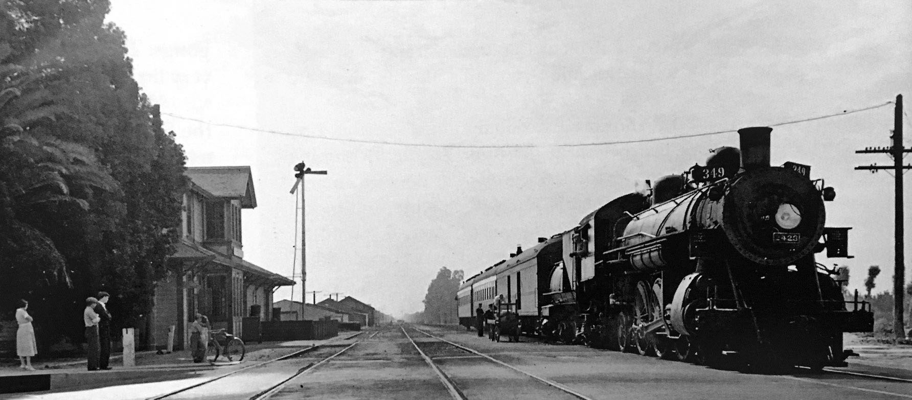
| (ca. 1938)* - Northridge Train Station on Reseda Boulevard in Northridge. Undated but after 1938, as the depot was given the name of Northridge that year. |
Historical Notes The Zelzah Train Station served as a shipping center for agricultural products grown in the area. Field workers would load locally grown crops onto trains at the station to be transported to other towns. The station played a significant role in the early development and growth of the Northridge community. |
 |
|
| (ca. 1938)* - View to the east showing westbound Santa Barbara local paused at the SP station, Northridge. |
Historical Notes Originally called Zelzah, the town that we call Northridge today was renamed North Los Angeles on July 1, 1929. In 1938, this area of the San Fernando Valley was renamed Northridge Village. Few evidences of the "village" remain. Northridge remains a stop for trains traveling to/from Santa Barbara. |
.jpg) |
|
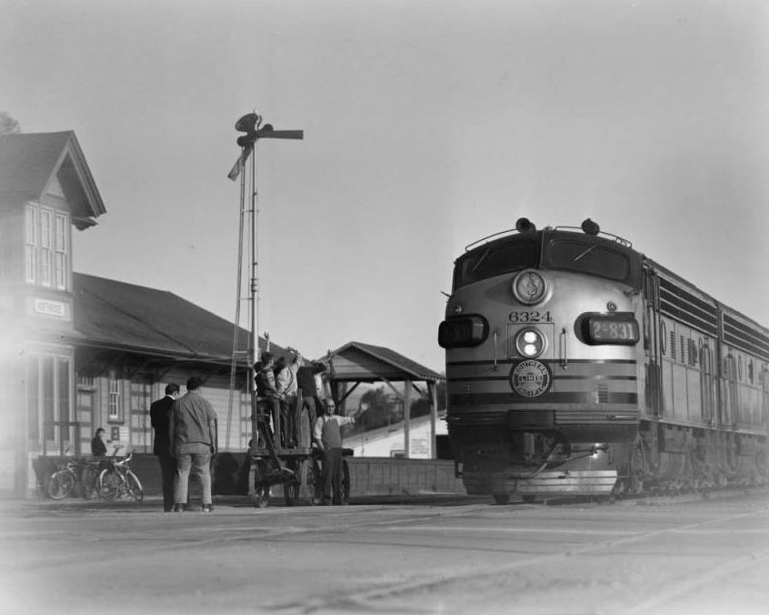
| (1938)* - Photo of the Northridge train depot in the Fall of 1938. The billboard to the left read: "S. P. Coach Fares SLASHED to San Francisco." |
Historical Notes With a new name in 1938, the Northridge Southern Pacific Railroad Station graced the north Valley until 1961. |
 |
|
| (1953)* - View of the picturesque Northridge Southern Pacific station. The station was built in 1910 in what was then Zelzah. |
Historical Notes The Zelzah Train Station (Today, Northridge Train Station) served as a shipping center for agricultural products grown in the area. Field workers would load locally grown crops onto trains at the station to be transported to other towns. The station played a significant role in the early development and growth of the Northridge community. The Northridge train station exists today and is an active Metrolink and Amtrak station serving the Northridge neighborhood. The current Northridge station is located at 8775 Wilbur Avenue in Northridge. It is owned by the Los Angeles Department of Transportation and situated on Metrolink's Ventura County Line. |
* * * * * |
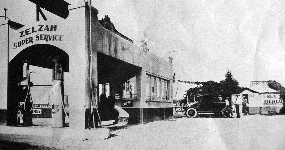
Zelzah Super Service Station (Northridge)
 |
|
| (ca. 1929)* - Zelzah Super Service Gas Station on the northeast corner of Reseda Blvd. and Gresham St. |
Historical Notes Click HERE to see more Early LA Gas Stations. |
Reseda
 |
|
| (1937)* - View of the Reseda Community Center as seen from an unpaved Victory Boulevard. |
 |
|
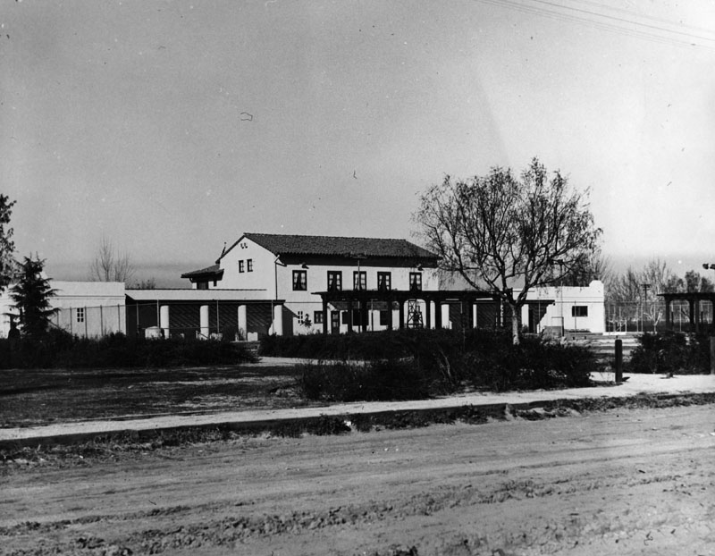
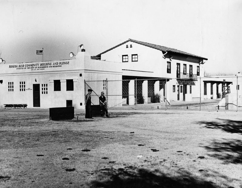
| (1937)* - Reseda Boulevard Community Building and Plunge located at 18411 Victory Boulevard. |
 |
|
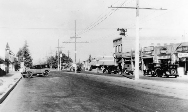
| (1938)* - View of Sherman Way one half block east of Reseda Boulevard. |
Historical Notes In May 1929, the city's namesake roadway, Reseda Avenue, was renamed Reseda Boulevard by a Los Angeles City ordinance. Parts of the original 1920s and 1930s residential neighborhood remain and are found to the southwest of Sherman Way and Reseda Boulevard.*^ |
 |
|
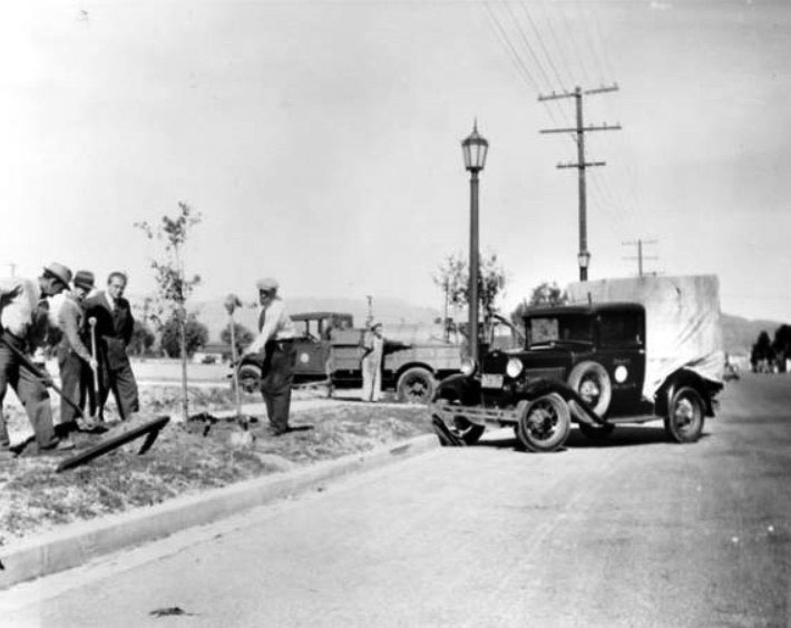
| (1938)#^ - Tree planting on Reseda Boulevard between Parthenia Street and Roscoe Boulevard. Carl S. Dentzel, a community leader, is visible at the center, wearing a suit. The other people in the photograph are from the Parks Department and Department of Forestry, City of Los Angeles. Note the new ornate streetlight on Reseda Blvd. (Click HERE to see more in Early L.A. Streetlights). |
* * * * * |
 |
|
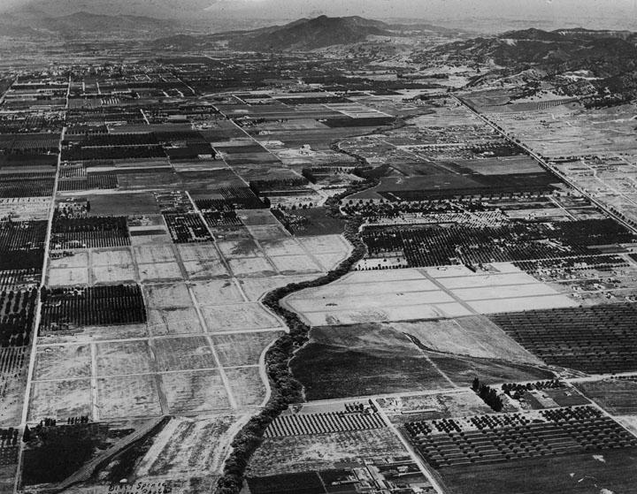
| (ca. 1930s)* - Aerial view of Sherman Oaks looking southeast from Sepulveda Blvd (bottom left to right) and Magnolia Blvd (left bottom to top). Ventura Blvd is on the right and Cahuenga Peak is center-top. The LA River is seen at center. |
 |
|
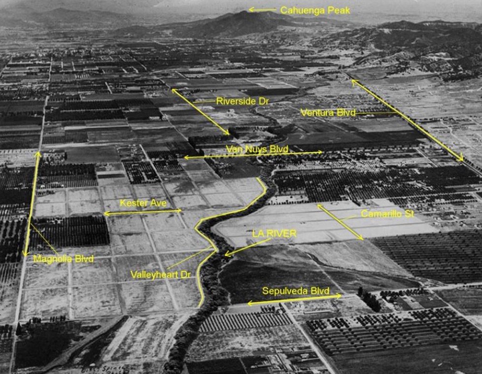
| (ca. 1930s)#^*^ – Aerial view of Sherman Oaks looking southeast. Same as previous photo but annotated with street names. Annotation by Rich Krugel at West San Fernando Valley – Then & Now. |
Flooding in the San Fernando Valley (1938)
 |
|
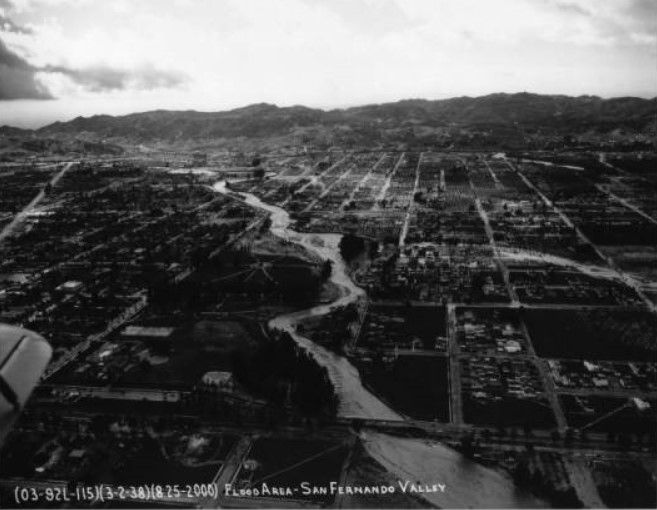
| (1938)^^ - Aerial view of flooded area of San Fernando Valley in March, 1938. At center, a wide river can be seen extending into the extreme background. At the center of the river, part of the river can be seen overflowing into the adjacent city blocks at right. A large stream of water covers several roadways and fields. |
Historical Notes Between February 27 and 28, 1938, a storm from the Pacific Ocean moved inland into the Los Angeles Basin, running eastward into the San Gabriel Mountains. The area received almost constant rain totaling 4.4 in from February 27-March 1. This caused minor flooding that affected only a few buildings in isolated canyons and some low-lying areas along rivers. Fifteen hours later on March 1, at approximately 8:45 PM, a second storm hit the area, creating gale-force winds along the coast and pouring down even more rain. The storm brought rainfall totals to 10 inches in the lowlands and upwards of 32 inches in the mountains. When the storm ended on March 3, the resulting damage was horrific.*^ |
 |
|
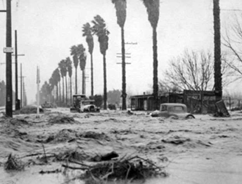
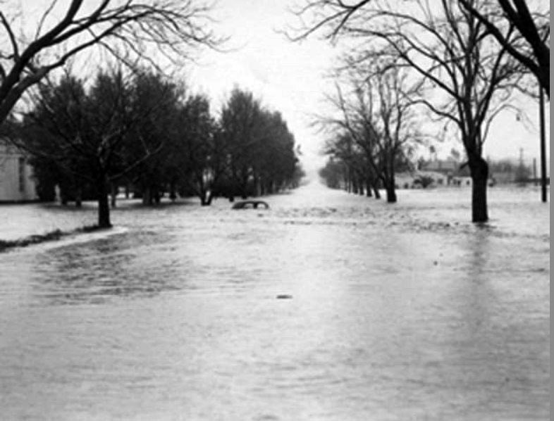
| (1938)^ - Sherman Way and Mason Avenue looking east during one of the worst floods in the Valley's history. |
Historical Notes The 1938 flood destroyed 5,601 homes and businesses, and damaged a further 1500 properties. The flooding was accompanied by massive debris flows of mud, boulders and downed trees which surged out of the foothill canyons. Transport and communication were cut off for many days as roads and railroads were buried, and power, gas and communication lines were cut. Dozens of bridges were destroyed, either by the sheer erosive force of floodwaters or by the collision of floating buildings and other wreckage. Some communities were buried as much as 6 feet deep in sand and sediment, requiring a massive clean-up effort afterward. It took from two days to a week to restore highway service to most impacted areas. The Pacific Electric rail system serving Los Angeles, Orange, San Bernardino and Riverside Counties was out of service for three weeks.*^ |
 |
|
| (1938)#^ - Looking south on Topanga Canyon Boulevard around Hart Street or Bell Creek. |
Historical Notes There have been eight major floods in the Valley since 1862, but the Los Angeles River Flood in 1938 was one the worst. The rains lasted for 3 days and streets throughout the San Fernando Valley were flooded. Although the 1938 flood caused the most damage of any flood in Los Angeles' history, the rainfall and river peaks were not even close to the Great Flood of 1862, the largest known flood by total volume of water. However, during the 1862 flood the region was much less populated than it was in 1938. About 108,000 acres were flooded in Los Angeles County, with the worst hit area being the San Fernando Valley, where many communities had been built during the economic boom of the 1920s in low-lying areas once used for agriculture. |
 |
|
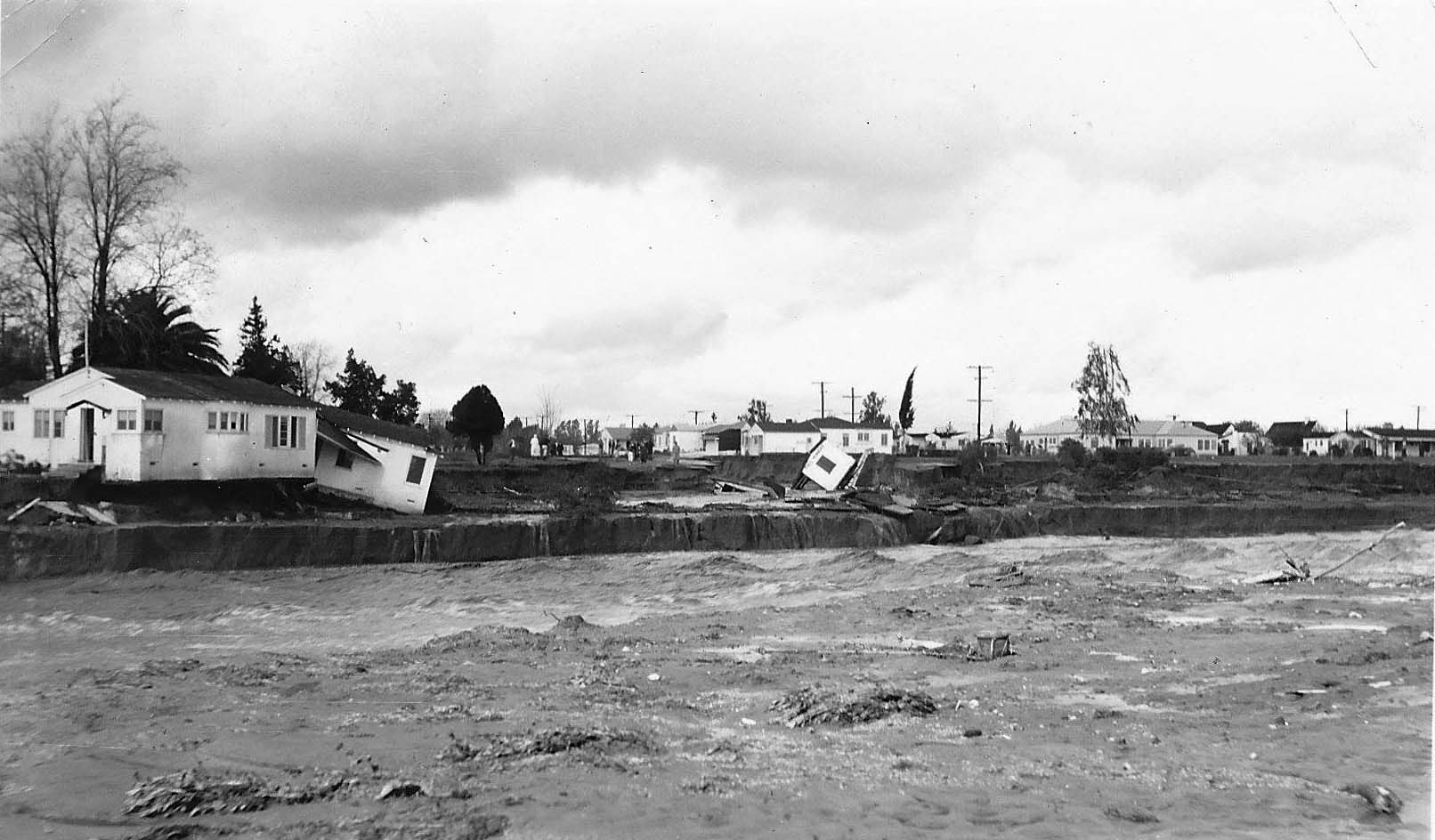
| (1938)^^^* - View of homes being washed away during the great storm of 1938. Photo taken at Riverside Drive and Tujunga Avenue looking west on March 4, 1938. |
Historical Notes After the 3rd straight day of torrential rain the Big Tujunga Wash levee broke. Seventy-seven of its spreading basins were destroyed. Telephones and electrical power was shut down. Buildings on the Warner Bros. lot and the Olive Avenue bridge were washed out. It took 30 days to clean-up the storm debris.^ |
 |
|
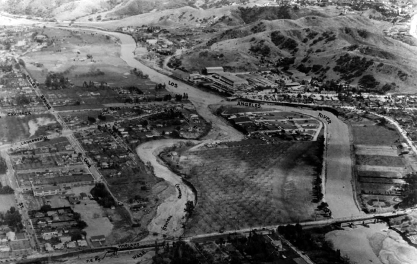
| (1938)^ - Aerial photograph of the confluence of the Los Angeles River and the Central Branch Tujunga Wash and surrounding area, March 3, 1938 during the 1938 Los Angeles River flood. Note both rivers are spilling over their banks and a portion of Vineland Avenue has been washed away (lower left). |
Historical Notes The Tujunga Wash reached its peak flow on March 3, with a water flow of an estimated 54,000 cubic feet per second. Upper Big Tujunga Canyon was "all but swept clean of structures that were not up above the flood line". In the San Fernando Valley, the floodwaters swept through many areas after escaping the normal channels of Tujunga Creek and its tributaries. Waters reached deep into the valley, flooding Van Nuys; five people died when the Lankershim Boulevard Bridge collapsed at Universal City, just below the confluence of Tujunga Wash and the LA River.*^ |
 |
|
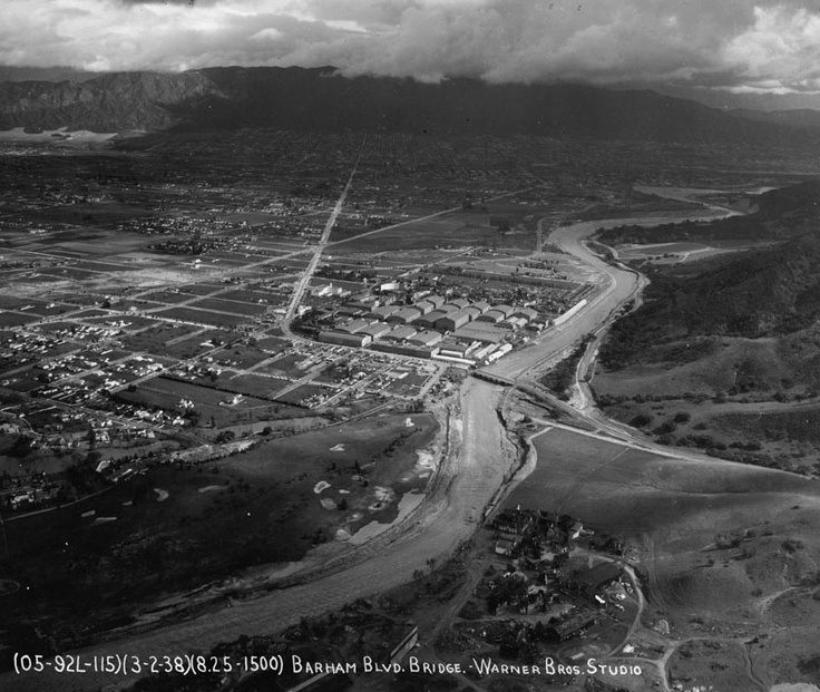
| (1938)^##* - An aerial view of Toluca Lake and Burbank as the waters of the Los Angeles River overflow its banks in March 1938. The Warner Bros. Studio is visible in the center of the picture. |
 |
|
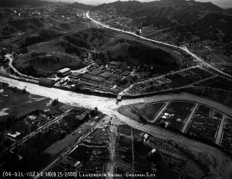
| (1938)* - Aerial view of the Lankershim Bridge in Universal City, that was destroyed by flood waters. People gathered at the ends of the bridge to watch the waters rage past the now destroyed bridge. |
 |
|
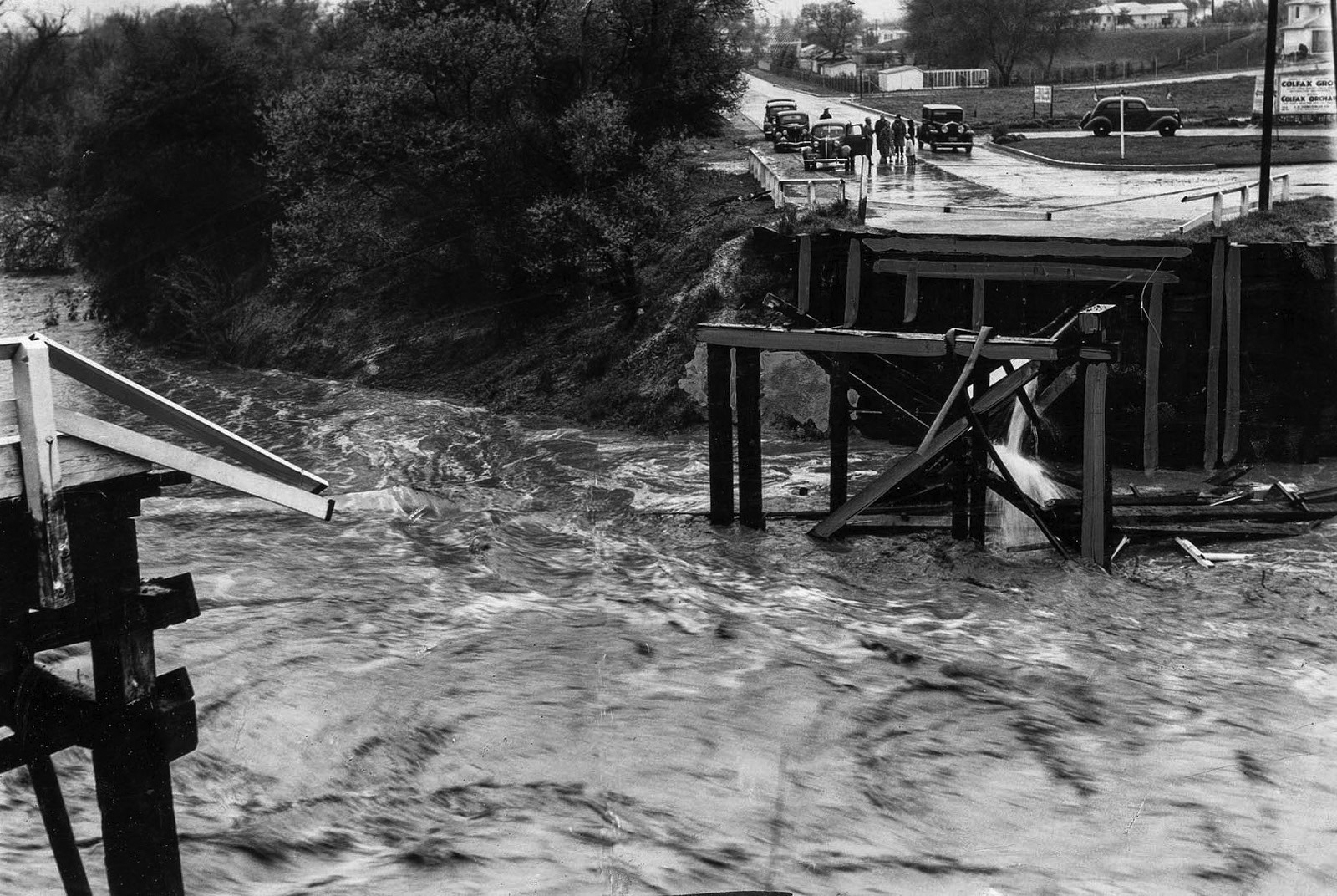
| (1938)#+ - Close-up view showing the washed-out bridge at Colfax Avenue over the Los Angeles River in Studio City. |
 |
|
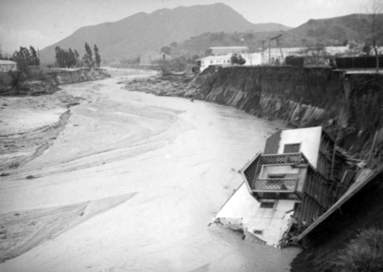
| (1938)* - A house sits on its side, half submerged at the bottom of the winding Los Angeles River in Toluca Lake. This was one of ten houses washed into the river in this area. |
 |
|
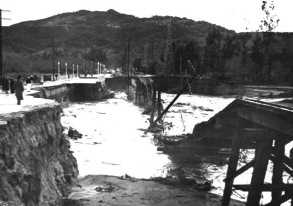
| (1938)^ – View looking south showing damage to the bridge and railroad tracks on Vineland Boulevard in North Hollywood due to the 1938 Los Angeles River flood. Photo date: March 3, 1938. |
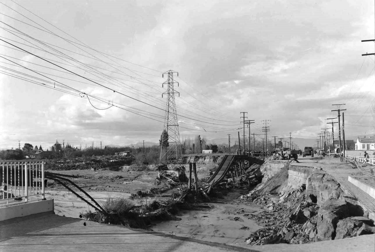 |
|
| (1938)#* – View looking north on Vineland Avenue in North Hollywood after the flood waters had receded. The Pacific Electric SFV Line Bridge is seen here totally destroyed. Note the crowd of onlookers held back by rope at rear center. Photo date: March 7, 1938. |
 |
|
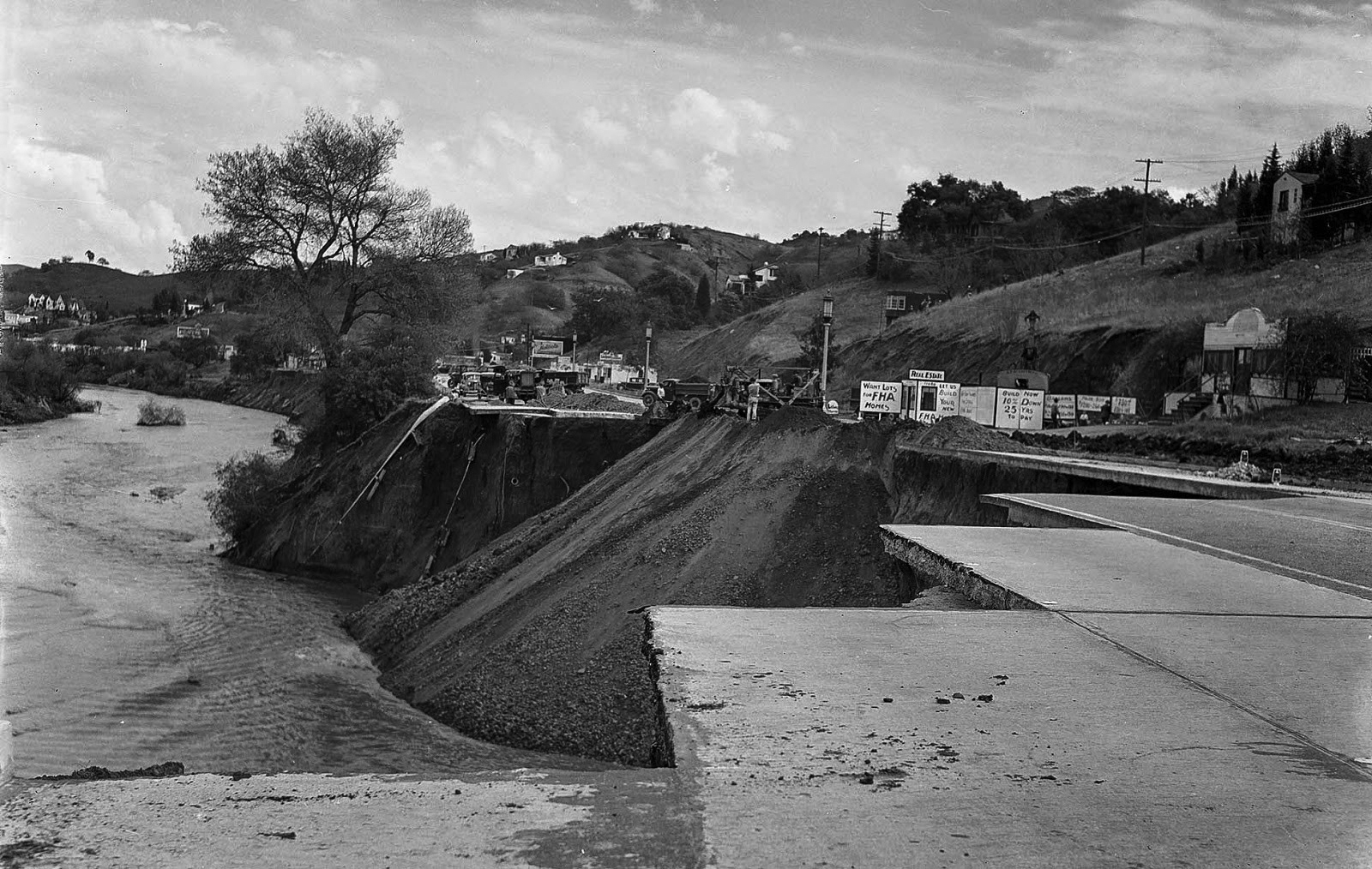
| (1938)#++ - Los Angeles city engineering crews fill in a 300-yard section of Ventura Boulevard near Laurel Canyon Drive that was gouged out by the swollen Los Angeles River on March 1. Photo date: March 7, 1938. |
Historical Notes After the great storm of 1938, due to public outcry, the Army Corps of Engineers began a 20 year project to create the permanent concrete channel which still contains most of the of riverbed today. Also, to install a network of channels, dams and flood basins to control the rampages of Valley waterways.* The introduction of the new flood control channels and the construction of dams (Hansen Dam and Sepulveda Dam) have alleviated most of the flooding problems of the past. |
* * * * * |
Channelization of the LA River
 |
|
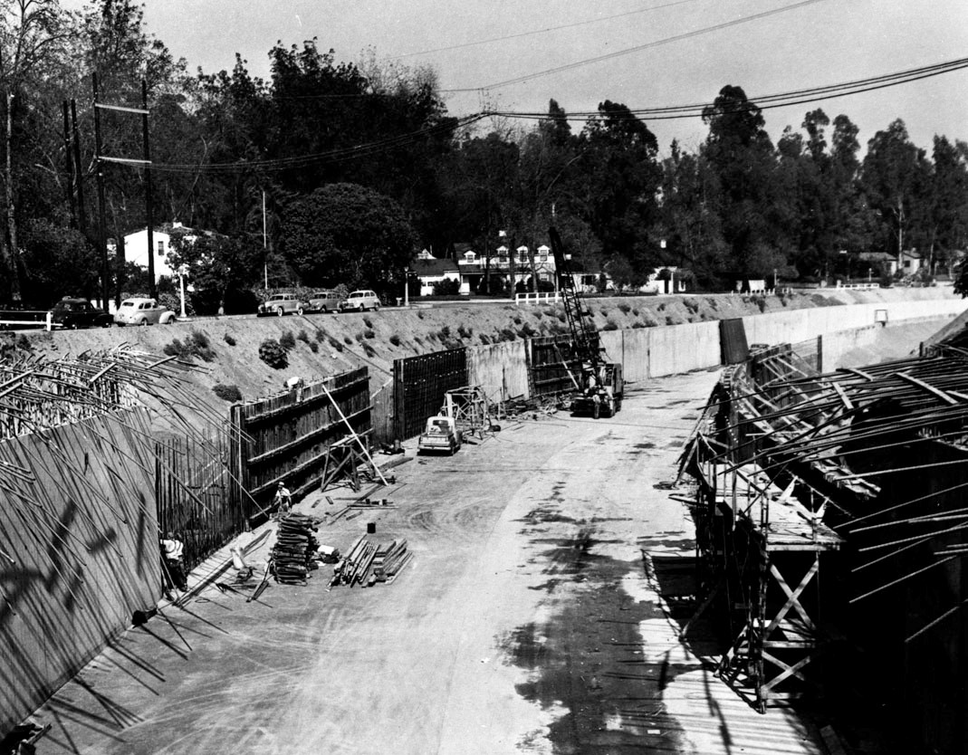
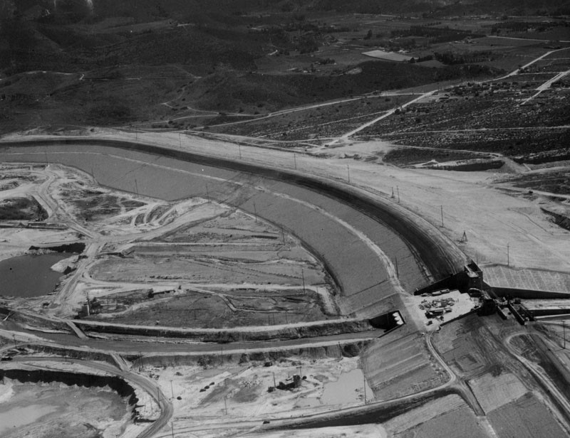
| (1949)* - View showing the construction of the channel walls in the Los Angeles River at Laurel Canyon in Studio City. |
Historical Notes Since 1938, 278 miles of river and tributaries were retrofitted and more than 300 bridges were built. With the river encased in cement, the natural sharp turns were now straightened. Any evidence of vegetation was completely removed, allowing runoff from the San Gabriel Mountains to escape through the river and out of Long Beach at up to 45 miles-per-hour. Streets and sewers were connected to drains along the river, designed to quickly capture and move rainfall away from the surrounding streets.^* |
 |
|
| (1938)*^ – Los Angeles River Channelization. View showing the placing of concrete in a section of the counterforted channel wall of the Los Angeles River. The men on the form are vibrating the concrete through windows which are progressively closed as the level of the concrete rises. |
Before and After
.jpg) |
|
.jpg) |
|
| (1937 vs. 2015)* - Before and After Los Angeles River Channelization in Studio City. |
Historical Notes “The Los Angeles River is small, but mean. People who don't know the truth of it make fun of our river; all they see is a tortured trickle that snakes along a concrete gutter like some junkie's vein. They don't know that we put the river in concrete to save ourselves; they don't know that the river is small because it's sleeping, and that every year and sometimes more it wakes. Before we put the river in that silly trough centered on a concrete plain at the bottom of those concrete walls, it flashed to life with the rain to wash away trees and houses and bridges, and cut its banks to breed new channels almost as if it was looking for people to kill. It found what it looked for too many times. Now, when it wakes, the river climbs those concrete walls so high that wet claws rake the freeways and bridges as it tries to pull down a passing car or someone caught out in the storm. Chain-link fences and barbed wire spine along the top of the walls to keep out people, but the walls keep in the river. The concrete is a prison. The prison works, most of the time.”
|
* * * * * |
Hansen Lodge
 |
|
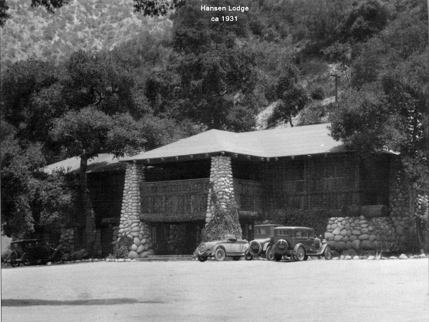
| (ca. 1931)* – View showing several early model cars parked in front of the Hansen Lodge located in Big Tujunga Canyon. |
Historical Notes Homer Hansen originally came to California in 1891 and spent time with the Tataviam tribe elder Sespe, who accompanied him when he scouted out the Big Tujunga. He returned to the east and became a doctor, but come 1903, his own physician advised that he had not long to live. He returned to the area, and after his arrival, he regained his health and built his rock house on a knoll in the middle reaches of the canyon, followed in 1910 by this two story lodge, which became a fashionable resort that attracted the top echelon of society for many years. This lodge was the talk of the elite in the 1920’s, who came to relax and have a pleasant entry into another world, assisted by the many stories told by Dr. Hansen of his early times in the region. The lodge was wiped out by a flood in 1926. Hansen sold the upper section of his property for construction of the Big Tujunga Dam, which was completed upstream from the lodge in 1931. Hansen then rebuilt the lodge. It was a good dam, but the 1938 storm sent water five feet deep over the spillway, whose crest height was 200 feet. This flood damaged the lodge beyond repair. A 1966 article describes that the chimney was still standing at that time. |
* * * * * |
Hansen Dam
 |
|
| (1939)* - Aerial view shows the construction of Hansen Dam. The project was built by the Los Angeles District Corps of Engineers between September 1939 and September 1940. |
Historical Notes The Los Angeles Flood of 1938, which included significant flooding along the Tujunga Wash and at its confluence with the Los Angeles River, increased support to dam and channelize the city's creeks and rivers. In 1939, due to repeated flooding and damage caused by them in the eastern portions of the San Fernando Valley, the U.S. Army Corps of Engineers began the project. In 1939 the Corps, by use of eminent domain, seized the horse ranch land of Homer and Marie Hansen to build to dam. |
 |
|
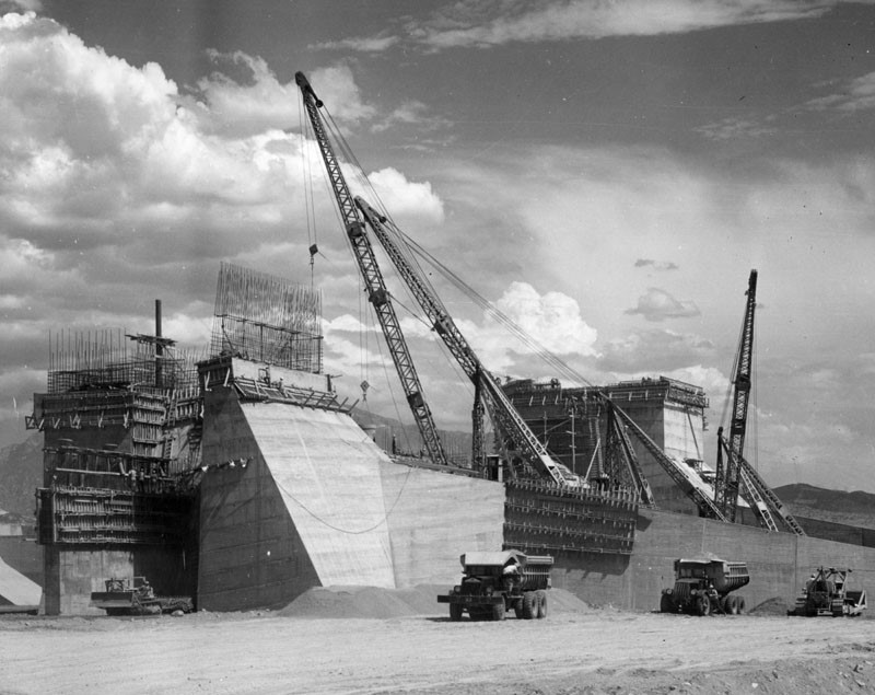
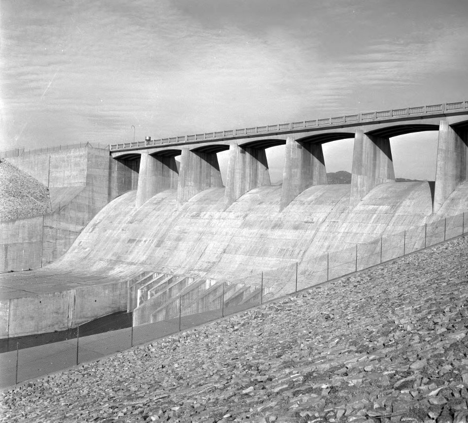
| (1940)* - This photo shows how Hansen Dam was built. Over the earth was spread a 6-inch layer of gravel, left. Over this was placed a thick layer of rock, right. The rock was dumped by the 30-ton truck at top, which was lowered by derrick from ramp where it was filled. |
Historical Notes Located in Big Tujunga Wash in the northeastern part of the San Fernando Valley, at the time of its construction the dam was the largest of its type in the world. It was designed by a large team of engineers in the U.S. Engineering Department and built by a workforce of nearly 1,000 men, supervised by general contractor Guy F. Atkinson Co. of San Francisco. |
 |
|
| (1940)* – Close-up view showing Hansen Dam's spillway from the downstream side during construction. The dam is located in what is now Lake View Terrace. |
Historical Notes ^Lake View Terrace, home to Hansen Dam, is a quiet equestrian community with two distinct faces: town and country. The east side is urban and densely populated, while the west has a rural feel, with homes zoned for horse-keeping and agriculture. Legend has it that Lake View Terrace derived its name from Holiday Lake, a 150-acre body of water that once sat behind Hansen Dam. A popular vacation spot in the 1950s, Holiday Lake has since dried up. |
 |
|
| (1940)* – Aerial view showing Hansen Dam nearly completed. Photo Date: August 7, 1940. |
Historical Notes Hansen Dam was dedicated on August 17, 1940, ten days after the above photo was taken. Located across Tujunga Wash, it was designed to hold back flood waters, reducing their flow in the San Fernando Valley by 81 per cent. The dam is two miles long and 102 feet high. |
 |
|
| (1940s)* – Close-up view of the Hansen Dam spillway. |
Historical Notes Hansen Dam is an enormous horseshoe-shaped earthen wall, up to a quarter mile wide at its base, with a monumental concrete spillway and outlet system at its center. The Moderne structure is designed not to stop the flow of water, but to slow and redistribute it to prevent catastrophic flooding events. The concrete spillway is topped by a long bridge supported by slender, wide flanges of sculpted concrete. Below it, gates and the main channel regulate the flow of water into an ever-widening area. A simple, hipped-roof concrete tower stands guard over it all, sheltering equipment and dam personnel monitoring all activity. The dam is a stunning illustration of the functional and aesthetic power of good design and construction, as epitomized by government work at the end of the Great Depression. |
 |
|
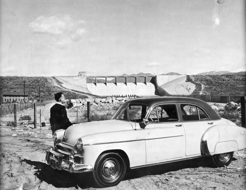
| (1949)* – A man standing by his 1949 two-tone Chevrolet looks out toward Hansen Dam. |
 |
|
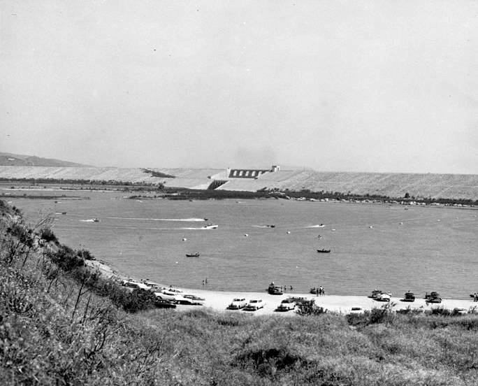
| (1950s)* – View showing the recreational facilities which attracted thousands of visitors per year after Hansen Dam was completed. |
Historical Notes In the mid-1940s, the Hansen Dam Basin's recreational possibilities were considered as it attracted thousands of visitors every year. Development of recreational facilities began in 1952 with the creation of Holiday Lake, which was used by swimmers, boaters, and anglers. By 1991, the lake had become completely filled with sediment and was abandoned. |
 |
|
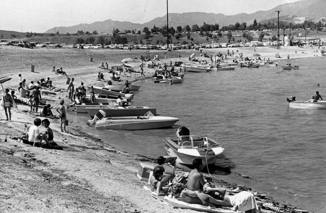
| (1962)* - Valley residents flock to Hansen Dam beaches for recreation as temperatures soared in the Valley. |
* * * * * |
Spencer Tracy Ranch
 |
|
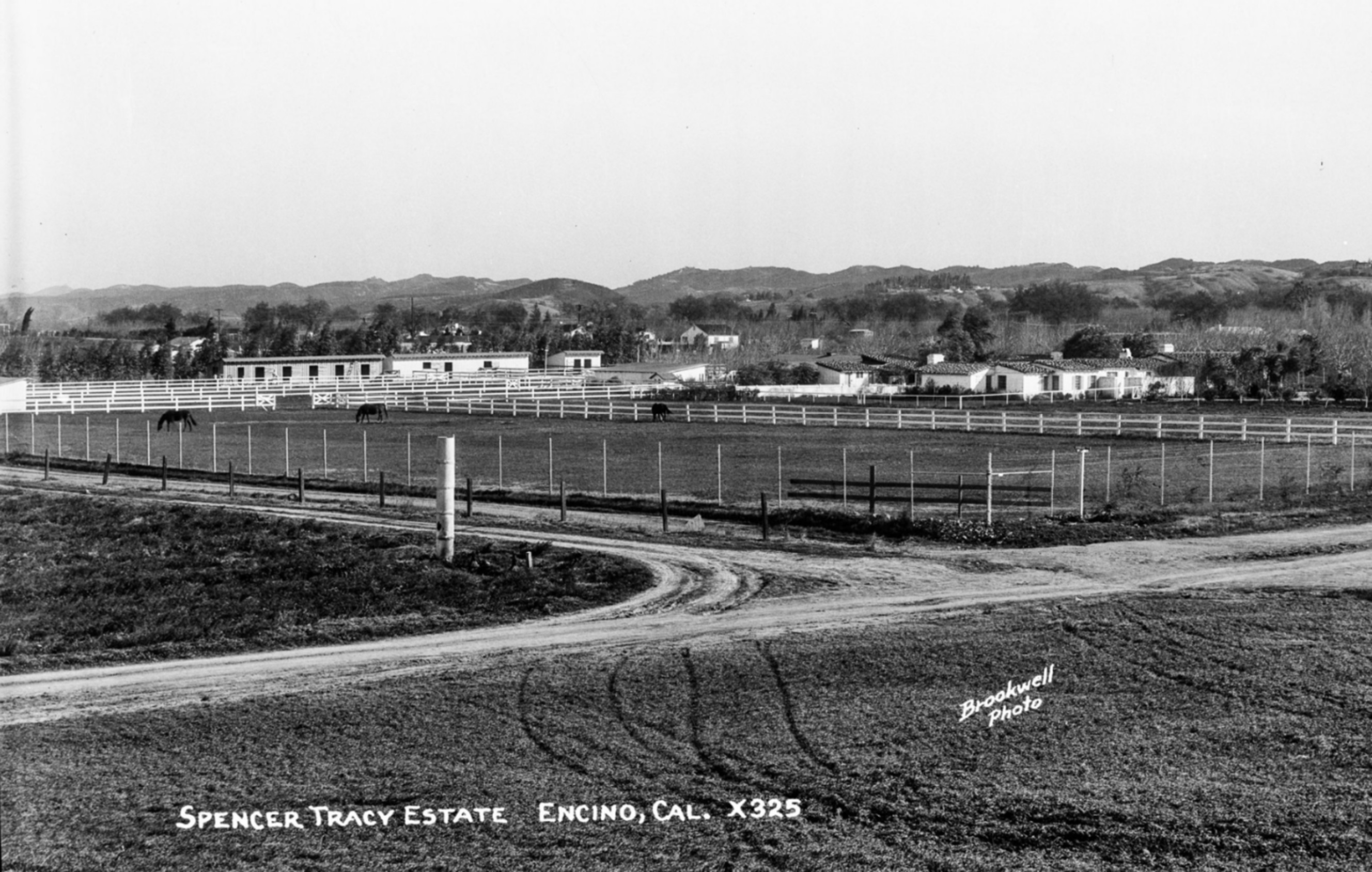
| (ca. 1936)*–Postcard view looking toward the 12-acre Spencer Tracy Estate (Ranch), located near the southeast corner of Burbank Boulevard and White Oak Avenue in Encino. Photo from the Ernest Marquez Collection. |
Historical Notes Known as "The Hill," the Spencer Tracy Ranch was a prominent 12-acre ranch nestled in Encino, in the San Fernando Valley, during the 1930s. Spencer Tracy and his wife, Louise, purchased the property in 1936 as a peaceful retreat from the bustle of Hollywood. The estate was located at 5508 White Oak Avenue, near what is now the southeast corner of Burbank Boulevard and White Oak Avenue. Ironically, today, hundreds of thousands of commuters speed past—unaware that just east of the White Oak Avenue underpass on the 101 Freeway, they're passing directly over the site where Spencer Tracy's ranch house once stood. |
 |
|
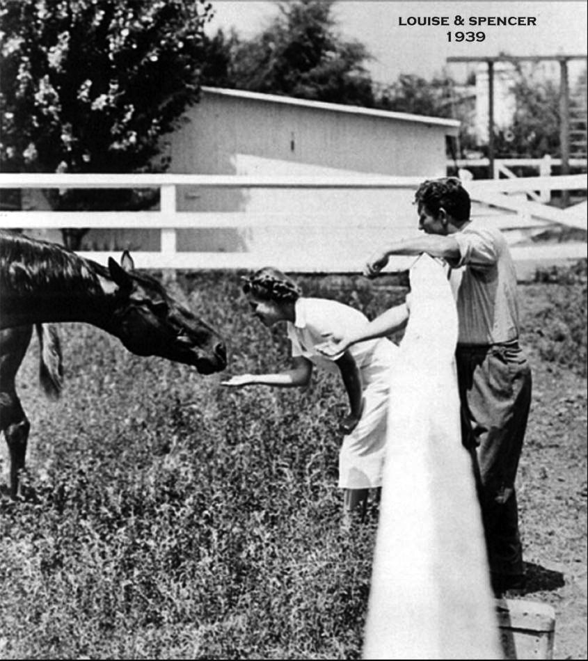
| (1939)* - Louise and Spencer Tracy at their Ranch located at 5508 White Oak Avenue, Encino. Today, the Ventura Freeway runs right through this ranch. |
Historical Notes The property was notable for its rustic charm and was furnished with early California antiques, reflecting a warm, historic ambiance. Spencer Tracy was known for his compassion toward animals, and the estate served as a sanctuary where no animals were harmed. This unique characteristic made the ranch stand out among other celebrity homes of the era, highlighting Tracy’s personal values and lifestyle. During the 1930s, Encino was a popular enclave for Hollywood stars like Clark Gable and Carole Lombard, who also owned large ranch-style properties nearby. The Tracy estate exemplified the trend of actors seeking refuge in the San Fernando Valley’s quiet, expansive ranches, combining privacy with a connection to nature.One of the major stars of Hollywood's Golden Age, Spencer Tracy won two Academy Awards for Best Actor from nine nominations, sharing the record for nominations in that category with Laurence Olivier. During his career, Tracy appeared in 75 films and developed a reputation among his peers as one of the screen's greatest actors. In 1999 the American Film Institute ranked Tracy as the 9th greatest male star of Classic Hollywood Cinema. |
* * * * * |
Encino Post Office & Store
 |
|
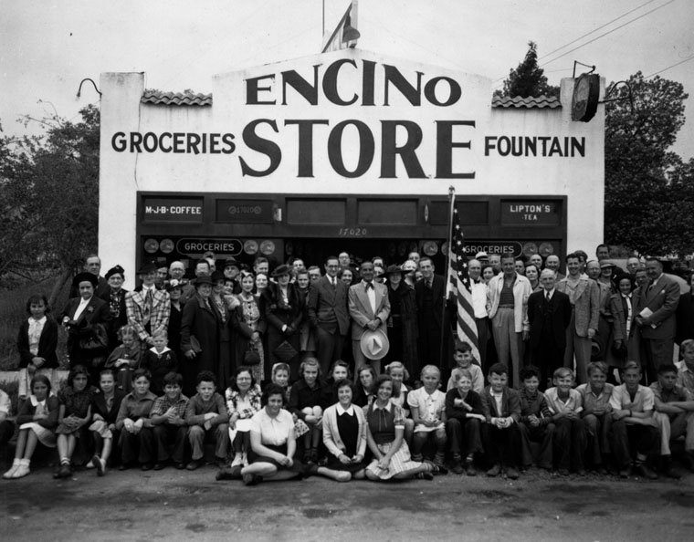
| (ca. 1938)* - Exterior view of the Encino Post Office, which shares a building with the Encino Store, located at 17020 Ventura Boulevard. A few celebrities from Encino are present in the image: Al Jolson, at center holding a white hat, the man next to the flag is actor Edward Evertt Horton. Just right of the flag is Peter Amestoy, in the dark suit with the white hair. Two people over to the right of the flag is the actor Phil Harris and two people from him on the right is actor Don Ameche. |
Historical Notes Peter Amestoy is the son of Domingo Amestoy who came to California by way of Argentina in 1851. Amestoy started a modest sheep business and within a few years he parlayed it into a fortune. He was one of the largest wool producers in Southern California during the 1860s. In 1871, he bought $500,000 worth of shares in the newly established Farmers and Merchants Bank in Los Angeles. In 1874 he went back to France and married. In 1875 Amestoy moved his family to 650 acres of the "Rosecrans Rancho" in what is now Gardena. By 1880, he had over 30,000 head of sheep, most of which were fine-wooled Spanish merinos. In 1889 he acquired all 4,500 acres of Rancho Los Encinos in the San Fernando Valley. After Domingo Amestoy died on January 11, 1892, his sons, John and Peter Amestoy, assumed ranch operations and changed the name to Amestoy ranch. Like other ranches in the San Fernando Valley at the time, the Amestoys cultivated wheat and barley. The Amestoy family held title to rancho for fifty-five years. In 1915, subdivision of the rancho began later developing into the communities of Sherman Oaks and Encino. The Amestoys held on to 100 acres, which included the old adobe until selling the property in 1944. Amestoy Avenue in the San Fernando Valley was named in honor of Domingo Amestoy (also Amestory Elementary School in Gardena). |
* * * * * |
Don Vicente de la Osa Adobe (Encino)
 |
|
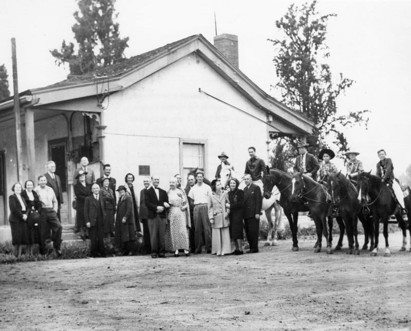
| (1937)* - Residents, actors and community leaders of Encino have gathered to commemorate the historical landmark status of the Don Vicente de la Osa Adobe (background) on Los Encinos Rancho. Actor Don Ameche is seen on the white horse near the center of the image. |
Historical Notes This dwelling, built in 1849 by Don Vicente de la Osa, was a favored stopping place for the numerous travelers on El Camino Real. It stands on land that is a part of the one-square-league Rancho El Encino granted in 1845 by Governor Pio Pico to three Indians, Ramon, Francisco, and Roque, whose interests were purchased by Don Vicente. Originally the land was under the jurisdiction of Mission San Fernando Rey, found in 1797. In 1937, the house received historical landmark status and a plaque was placed by the Native Daughters of the Golden West. Click HERE to see more on the Los Encinos Rancho. |
* * * * * |
Valley Recreational Center (Studio City)
 |
|
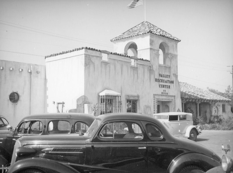
| (ca. 1939)* - Cars are parked in front of the Spanish-style Valley Recreation Center, located at 12229 Ventura Boulevard in Studio City. |
Historical Notes This building, which opened in 1938, is no longer standing. Today, a Chinese Restaurant and Medical Eye Office stands at this location. Click HERE for contemporary view. |
* * * * * |
Studio City Theatre (Now, Bookstar/Barns & Noble)
 |
|
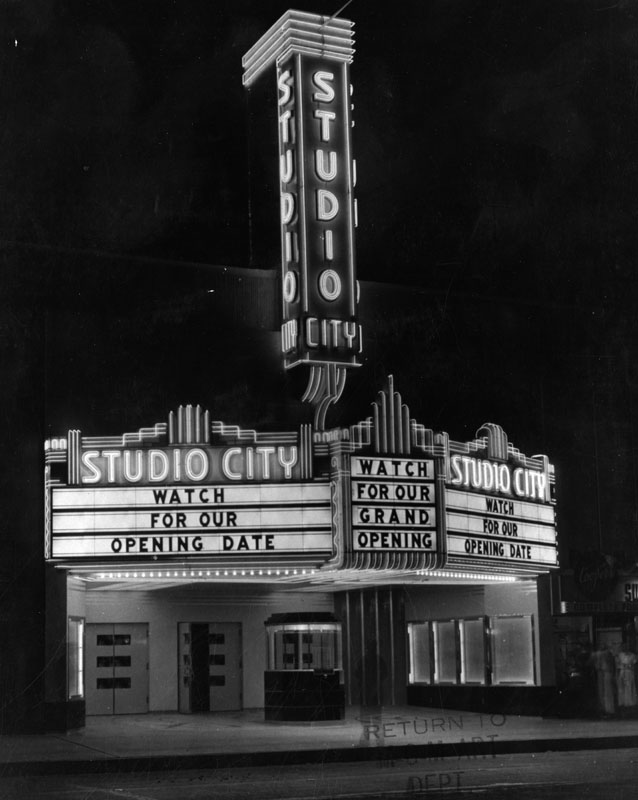
| (1938)* - A lighted marquee at Studio City Theater reads, "Watch for our opening date" and "Watch for our grand opening." The theater is located at 12136 Ventura Blvd. in Studio City. |
Historical Notes Opened in 1938 the Studio City Theater was operated by Fox West Coast Theatres and its successor companies. The last operator was Mann Theatres. It's been known as the Studio Theatre, the Studio City Theatre and the Fox Studio City. The theater closed in 1991. The interior is largely intact but has been converted into a Bookstar/Barnes & Noble bookstore. Click HERE to see contemporary view. |
* * * * * |
La Reina Theatre (Sherman Oaks)
 |
|
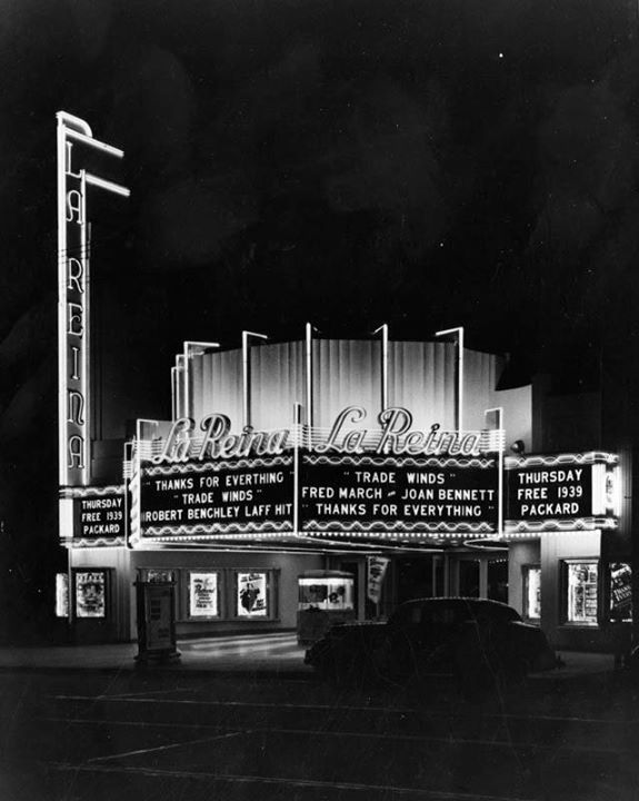
| (1939)* - Exterior view of the La Reina Theater, located at 14626 Ventura Boulevard in Sherman Oaks. Movies currently showing are "Thanks for Everything" and "Trade Winds", starring Fred March, Joan Bennet, and Robert Benchley. |
Historical Notes The theater, which opened in 1938, and was designed by famed architect S. Charles Lee. The theatre originally held 875 seats and was one of the most stylistically sophisticated theaters ever built in the San Fernando Valley.*^^^ In the mid-1980s, Mann Theaters sold the theater to developers who wanted to use the theater’s lot for a new shopping mall. Such stories usually end sadly, but as a slight concession to preservationists, the developers were forced to save the theater’s facade, although the auditorium was demolished. After the 1995 Northridge earthquake, the vertical tower was damaged and had to be removed, and today all that remains is the marquee, the ticket booth, terrazzo sidwalk floor, and the facade of the building. Click HERE to see contemporary view. |
* * * * * |
Frankie's Brass Rail Restaruant (Sherman Oaks)
 |
|
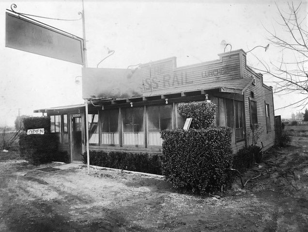
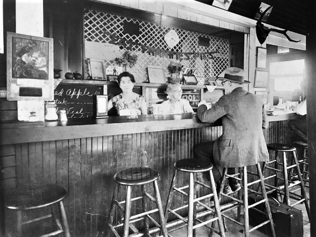
| (1929) – Frankie's Brass Rail Restaurant located at 13747 Ventura Blvd, Sherman Oaks. This was one of the first “stand-alone” restaurants in the SFV. Kerry Davenport’s family photo collection, Photo courtesy of Carla Bollinger |
Historical Notes In the same year as the 1929 Stock Market Crash-Great Depression began, Frankie Davenport made a bold move and opened “Frankie’s Brass Rail” restaurant in the San Fernando Valley. She would go on and open the restaurant in three different locations, all in the San Fernando Valley. |
 |
|
| (1930) – Brass Rail Restaurant interior view showing a customer sitting at counter. The two women behind the counter are Frankie Davenport and her mother, Marcellina Hasam (Kerry Davenport’s grandmother and great-grandmother respectively). Kerry Davenport’s family photo collection, Photo courtesy of Carla Bollinger |
Historical Notes Frankie's restaurant became so popular that in 1933 she would move to a larger place located just 2 blocks to the east at 13555 Ventura Blvd. |
 |
|
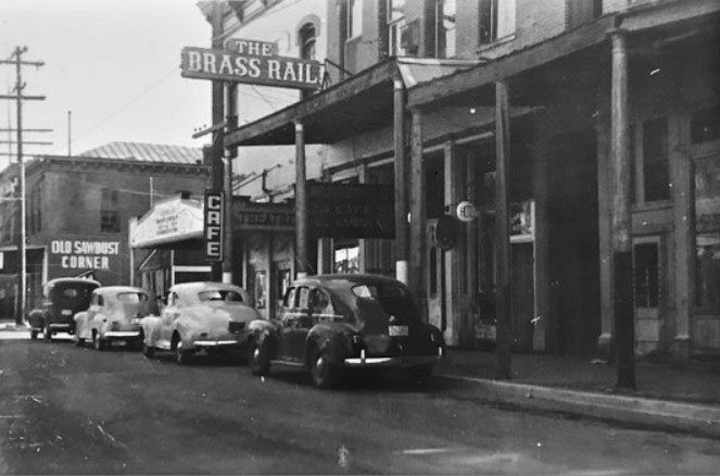
| (1940s) – Frankie’s Brass Rail at its 2nd location, 13555 Ventura Blvd., Sherman Oaks (near “Old Sawdust Corner”) and in-between the theater and hotel. Kerry Davenport’s family photo collection, Photo courtesy of Carla Bollinger |
Historical Notes The patronage at her second location grew so steadily and became so large that Frankie decided to relocate her restaurant once again. She moved to a new building situated a short block away at 13562 Ventura Blvd. The opening date of the new Brass Rail would be June 1, 1938, which happened to be the same day Frankie married her second husband, Carl Graham. |
 |
|
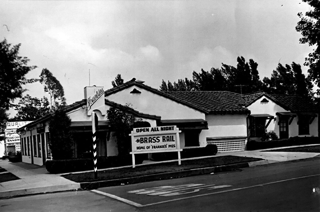
| (ca. 1947) – Frankie's Brass Rail Restaurant at its 3rd location at 13562 Ventura Boulevard, SE corner of Ventura Blvd and Ventura Cyn Ave. Parkway sign reads: Open All Night – Brass Rail – Home of ‘Frankie's Pies. Kerry Davenport’s family photo collection, Photo courtesy of Carla Bollinger |
Historical Notes Frankie sold her restaurant in 1947. Eventually Dick Whittinghill, Popular Radio DJ, Station KMPC, bought the restaurant in the late 1950s-early 1960s. Prior to opening her first restaurant, Frankie was a seamstress in the entertainment studios. After selling her third restaurant she moved to Ventura County and became a real estate agent. She worked as an agent into her 90’s. Clients trusted Frankie’s judgement and advice and picked her up to drive her to real estate properties. Today, the above site is occupied by a private school. Click HERE for contemporary view. |
* * * * * |
Blu-Green Gas Station (Sherman Oaks)
 |
|
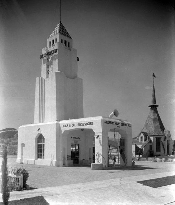
| (1930s)#** – View of the Art-Deco style Sherman Oaks Service Station located at 15362 Ventura Blvd, near the southeast corner of Ventura Blvd. and Sherman Oaks Ave. |
Historical Notes Blu-Green Gas was sold at Gilmore Gas Stations. Click HERE to see more Early Views of LA Gas Stations. |
* * * * * |
Royal Albatross (Studio City)
 |
|
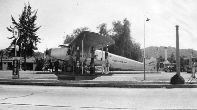
| (1939)* - View of the Royal Albatross, an airplane used as a service station, located on the eastern vertex of a narrow strip of land bordered by Ventura Boulevard (south), Ventura Place (north, seen here, foreground). Gasoline pumps are set up under the wing spans. |
Historical Notes The Zenith Model 12 didn’t work out too well. It was an attempt to travel on the success of Henry Ford’s trimotor. It was underpowered and not a roaring success. It became a one of a kind airplane. However, it wasn’t totally useless. Someone saw it as a gasoline station. It was set up as part of a Texaco station in the gore point created by the intersection of Ventura Boulevard and Ventura Place in Studio City opposite Republic Studios.^ |
 |
|
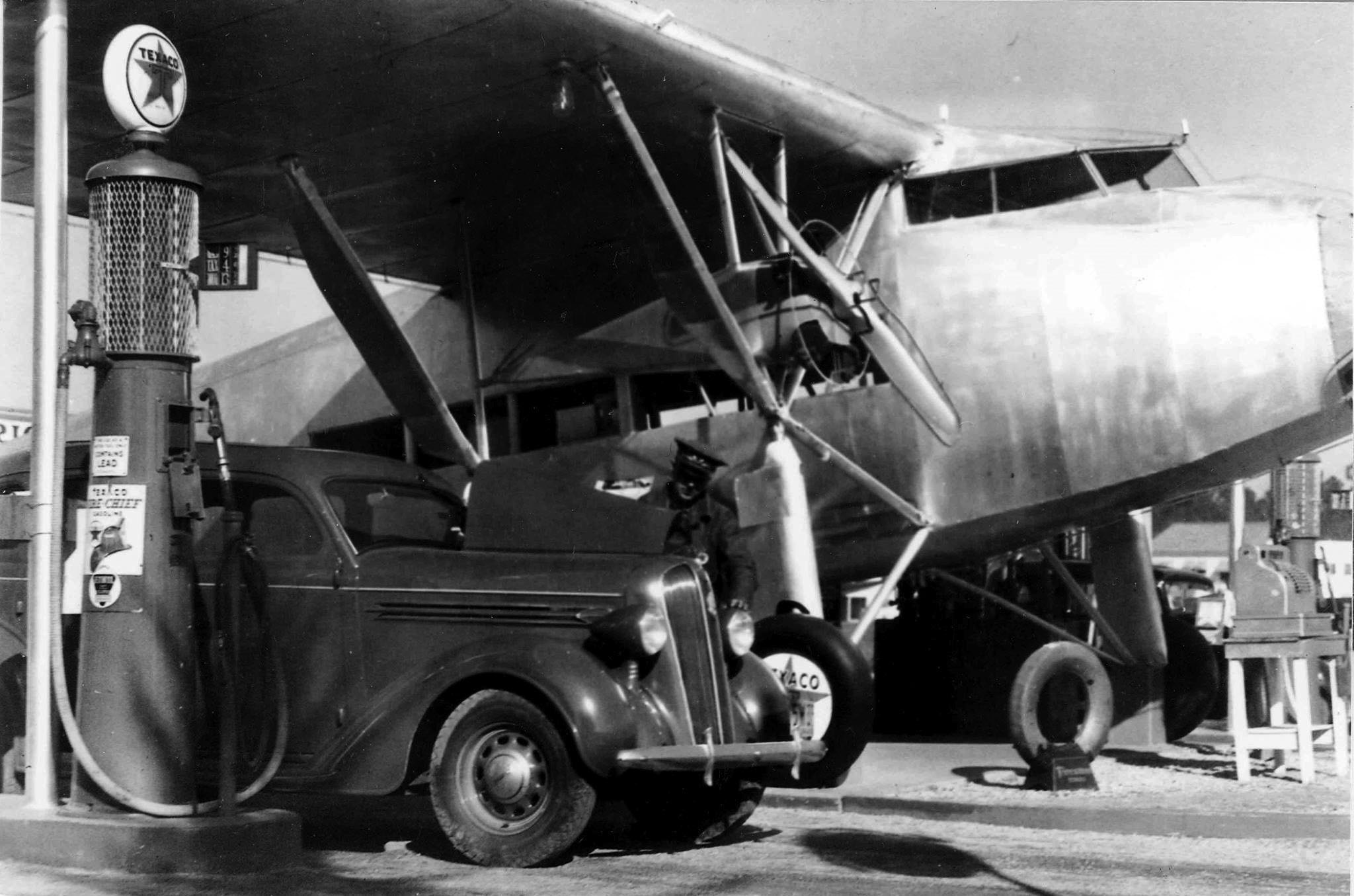
| (ca. 1939)^ - Close-up view showing an attendant servicing a car at the Royal Albatross Texaco Service Station in Studio City. Note the cash register on the right. |
Historical Notes In the 1920s and 1930s, as the automobile was becoming the default way to get around the Southland, buildings and structures in the area became more unique. These “hey-you-can’t miss-me!” buildings (referred to as Novelty or Programmatic Architecture) were made to pull automobile drivers right off the road. Click HERE to see more examples of Programmatic Architecture. |
Then and Now
 |
|
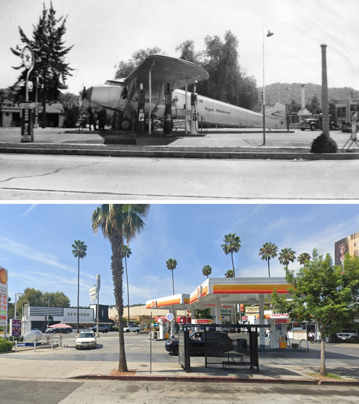
| (1939 vs 2022)* - Looking at the NW corner of Ventura Boulevard and Ventura Place showing a Shell gas staton where the Royal Albatross, an airplane used as a service station, once stood. Photo comparison by Jack Feldman. |
* * * * * |
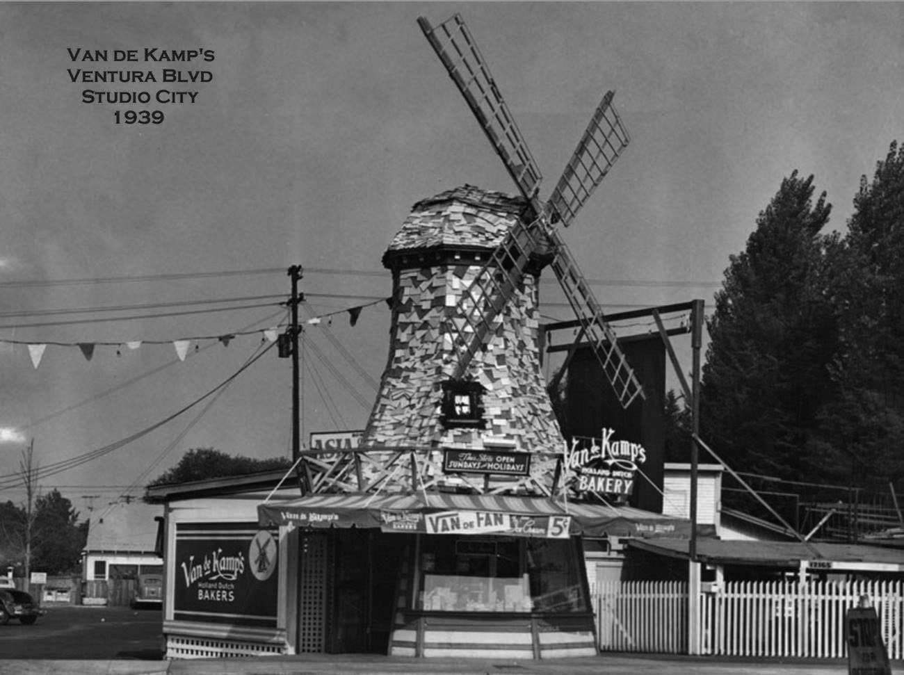
Van de Kamp's
 |
|
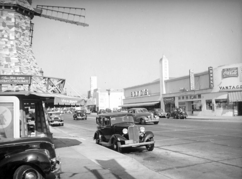
| (ca. 1939)* - This view looking east on Ventura from Vantage towards Laurel Canyon in Studio City includes the traditional windmill style Van de Kamps Holland Dutch Bakery at 12169 Ventura Boulevard and the Bond's Market at 12160 Ventura Boulevard across the street. |
Historical Notes Theodore J. Van de Kamp and brother-in-law Lawrence L. Frank were the owners and originators of the Van de Kamp Bakeries. Fondly known as the "Taj Mahal of all bakeries". Van de Kamp and Frank also founded both the Tam O'Shanter's (1922) and Lawry's The Prime Rib (1938) restaurants.*^ |
 |
|
| (1939)^ – Front view of the Van de Kamp’s Bakery located on Ventura Boulevard in Studio City, at the end of the T-intersection with Vantage Avenue, today the site of a 'Gap' Store. |
Historical Notes There are no traditional windmill Van de Kamp's buildings left standing in the San Fernando Valley. One early Van de Kamp windmill survives, altered, sans blades, at 4157 South Figueroa St, Vermont Square. A newer, hexadecagon (16-sided) with a folding plate roofline (Harold Bissner & Harold Zook, 1967) survives under Denny's livery, 7 East Huntington Drive, Arcadia. |
 |
|
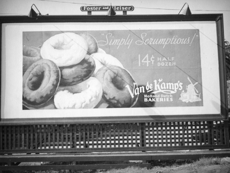
| (1937)* - A Foster and Kleiser billboard advertising doughnuts sold at Van de Kamp's Bakeries. Photo by Herman J. Schultheis |
Historical Notes The bakery was sold by the Van de Kamp family and acquired by General Baking Co. in 1956. The company was sold to private investors in 1979, and closed in bankruptcy in 1990. The Van de Kamp's brand is now owned by Ralphs supermarket chain and used for their line of private-label baked goods.*^ |
* * * * * |
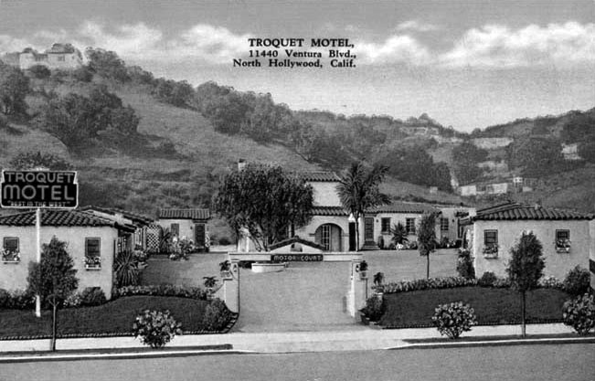
Troquet Motor Motel
 |
|
| (1930s)*#^# - Postcard view showing the Troquet Motor Motel located at 11440 Ventura Boulevard, Studio City. |
 |
|
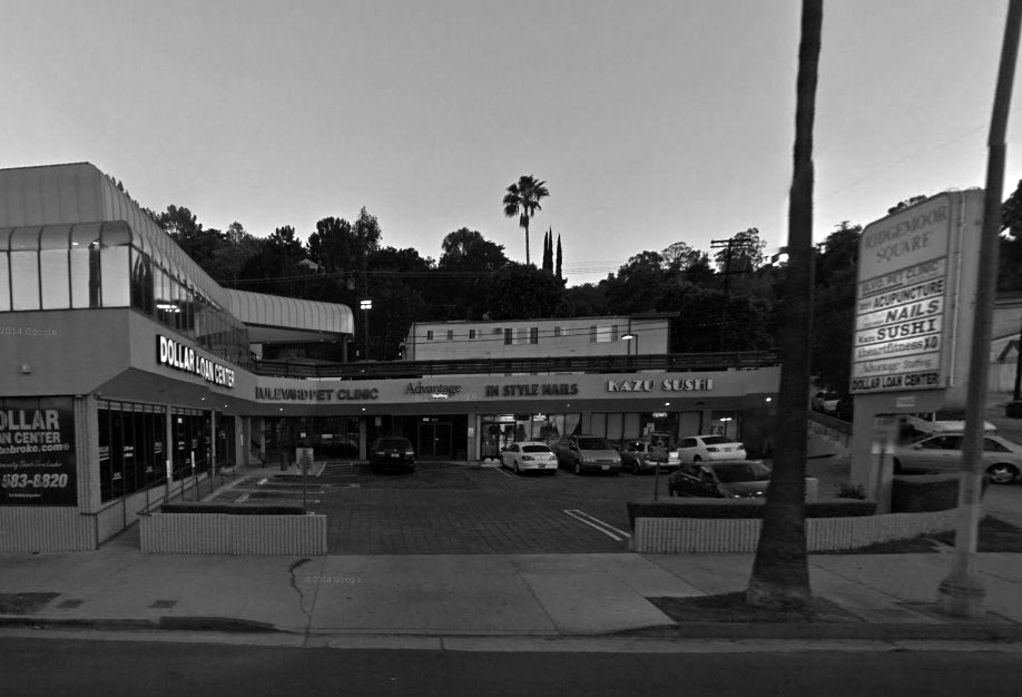
| (2014)#*^# - Google street view showing the Ridgemoor Square, located at 11440 Ventura Blvd (S/W corner of Ventura and Ridgemoor Dr), Sutdio City. |
Before and After
|
 |
|
| (1930s)*#^# - Troquet Motor Motel, S/W corner of Ventura and Ridgemoor Dr. | (2014)#*^# - Ridgemoor Square, S/W corner of Ventura and Ridgemoor Dr. |
* * * * * |
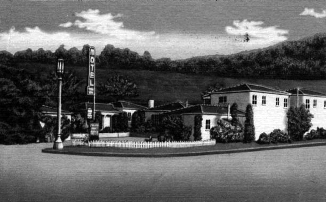
Cypress Motor Motel
 |
|
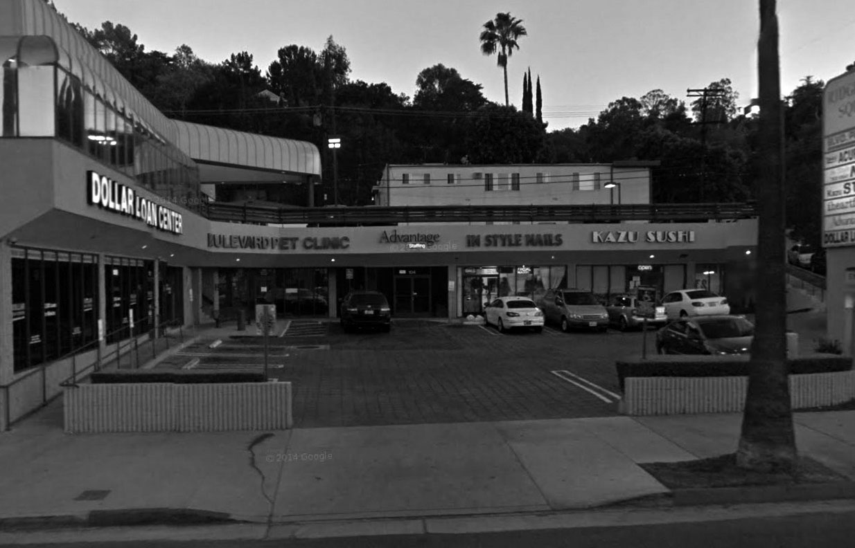
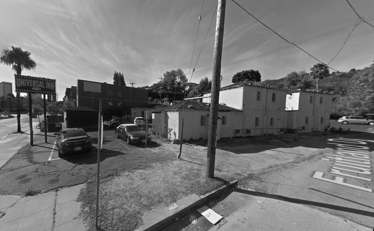
| (1930s)^^^* – Postcard view showing the Cypress Moter Motel located at 10740 Ventura Boulevard (S/E corner of Ventura and Fruitland Drive). |
 |
|
| (2014)#*^# – Google street view showing the Universal Inn located on the southeast corner of Ventura Blvd and Fruitland Dr. |
Before and After
|
|
|
| (1930s)^^^* – Cypress Moter Motel, S/E corner of Ventura and Fruitland Dr. | (2014)#*^# – Universal Inn, S/E corner of Ventura and Fruitland Dr. |
Cahuenga Pass
 |
|
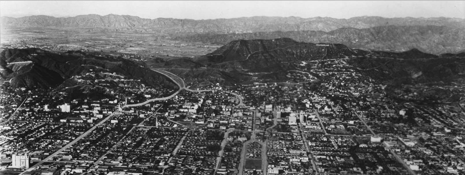
| (ca. 1930s)^^ - Panoramic aerial view over Hollywood showing the Cahuenga Pass as it heads toward a sparsely populated San Fernando Valley. Click HERE to see more in Early Views of Hollywood. |
Historical Notes The Cahuenga Pass has long been a convenient shortcut between the San Fernando Valley and Los Angeles Basin. The first Southern Californians likely blazed a foot-trail millennia ago, and by the late 18th century the villagers of Cabueg-na or Kaweenga (the origin of the name "Cahuenga") near Universal Studios regularly trekked through the pass. In 1852, a steep wagon road replaced the old trail, and in 1911 the Pacific Electric stretched its interurban railway tracks through the pass. Any remnants of the pass' rustic character vanished in 1940, when the Cahuenga Pass Freeway -- one of L.A.'s first – opened.**^^ |
Click HERE to see more Early Views of Cahuenga Pass |
* * * * * |
East San Fernando Valley
 |
|
| (1930s)^^ - Panoramic view of the East San Fernando Valley as seen from the Hollywood Hills. |
 |
|
| (1939)^^ - Panoramic view looking over the Santa Monica Mountain ridge with a dirt road (Mulholland) cut into it toward the largely undeveloped San Fernando Valley. |
 |
|
| (1939)^^ - View of the West San Fernando Valley looking north as seen from Topanga Canyon. The Santa Susana Mountains can be seen in the background. |
 |
|
| (1939)^^ – View looking east over Universal City Studios toward Burbank and the Verdugo Mountains. |
 |
|
| (1939)^^ - Looking east across the Cahuenga Pass showing Universal City in the background. |
 |
|
| (1939)^^ - Looking east across the Cahuenga Pass from the Santa Monica Mountains showing Universal City and the eastern part of the San Fernando Valley. |
* * * * * |
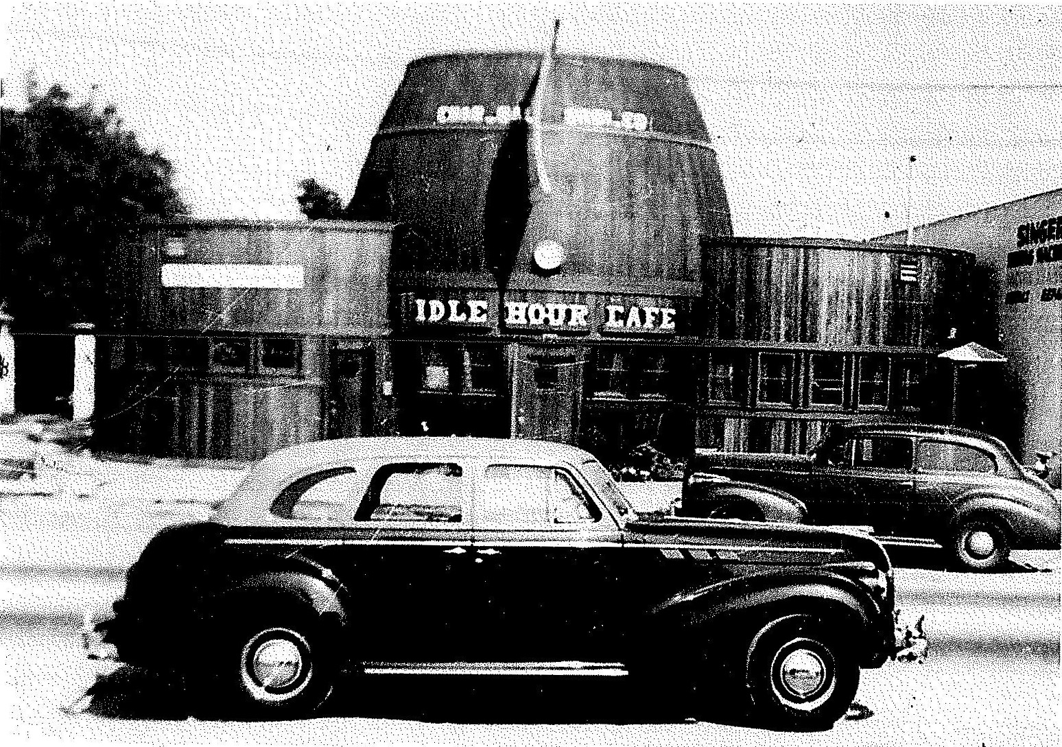
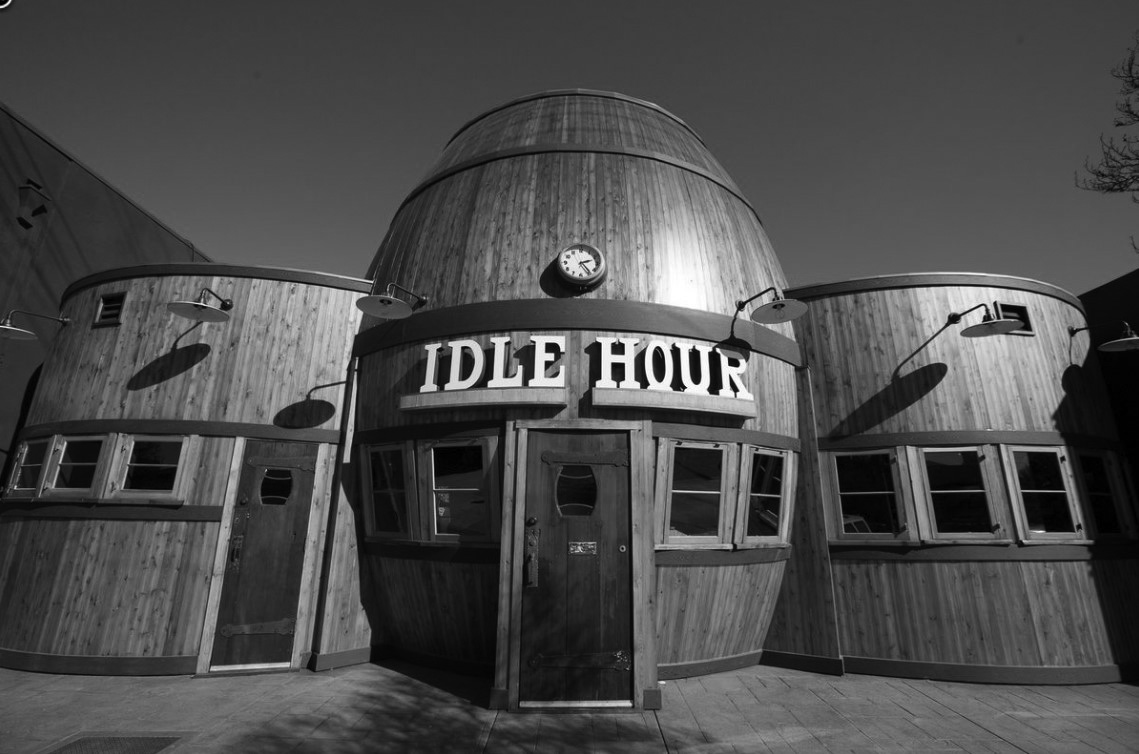
Idle Hour Café
| (ca. 1941)* – View showing the intersection of Lankershim, Camarillo & Vineland in North Hollywood. The historic Idle Hour Café shaped in the form of a barrel is seen at center-left on Vineland Avenue. |
Historical Notes Constructed in 1941, the Idle Hour Café building is a two-story, barrel-shaped building constructed in the Programmatic style. The building was commissioned by Universal Studios film tech Michael D. Connolly and built by Silver Lake engineer George F. Fordyk.*+* |
 |
|
| (1941)*+* - View showing the Idle Hour Café the year it opend, located at 4824 Vineland Avenue, North Hollywood. |
Historical Notes Michael D. Connolly, the original owner/builder, was a film technician for Universal Studios, creating daily rushes for movie directors. In 1940, he acquired the land in North Hollywood for his Café and Tap Room, less than two miles from the studio. Connolly and his wife Irene would live above their new venture in a small apartment built into the head of the barrel, completed in 1941. On December 7, the United States was attacked at Pearl Harbor and Michael enlisted as a cook in the Merchant Marines. Upon his return he and Irene divorced. Irene continued running the café into the 1960s. Late in that decade it was renamed Rudy’s Keg.*+* |
 |
|
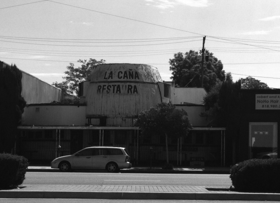
| (2011)++* – View showing the La Caña Restaurant (Idle Hour Café), before its recent renovation. Photo by Lindsay William-Ross |
Historical Notes In 1971, the building was purchased by renouned flamenco dancers Jose and Dolores Fernandez. The pair redecorated the dining room to create a dinner theater called La Caña. The restaurant closed in 1984 but Dolores continued to live in the upstairs apartment until 2009. The building would be shuttered for over 27 years. #*#* |
 |
|
| (2015)#*#* – View showing the newly renovated Idle Hour Café, located at 4824 Vineland Avenue. Photo by Elizabeth Daniels |
Historical Notes In 2010, the City of Los Angeles designated the Programmatic style building Historic-Cultural Monument No. 977. The following year the "1933 Group" purchased the property and by 2015 the fully restored barrel-shaped building would once again open as the Hour Café. The barrel was actually once a more common type of mimetic architecture; local examples included The Barrel Inn, 1525 San Fernando, 1927; Twin Barrel Drive-in, 7200 Beverly Blvd., 1932, Giant Barrel, Los Angeles, 1935; as well as other exmaples around the country. The Idle Hour is the last remaining barrel-shaped structure in the Los Angeles area.*+* Click HERE to see more examples of Programmatic Architecture. |
* * * * * |
Please Support Our CauseWater and Power Associates, Inc. is a non-profit, public service organization dedicated to preserving historical records and photos. Your generosity allows us to continue to disseminate knowledge of the rich and diverse multicultural history of the greater Los Angeles area; to serve as a resource of historical information; and to assist in the preservation of the city's historic records.
|
More Historical Early Views
Newest Additions
Early LA Buildings and City Views
History of Water and Electricity in Los Angeles
* * * * * |
References and Credits
* LA Public Library Image Archive
^ CSUN Oviatt Library Digital Archives
#^San Fernando Valley History Digital Library - CSUN Oviatt
**DWP - LA Public Library Image Archive
^* The Valley Observied: Street Name Origins; Timeline of Valley History
^# Chatsworth Historical Society; Chatsworth History Timeline
*# Mojave Desert.net: Remi Nadeau
***Los Angeles Historic - Cultural Monuments Listing
*^*California Historical Landmarks Listing (Los Angeles)
+*+Undereverystone.blogspot.com: LA Pet Cemetery
^^^LA Times: Adohr Spelled Succes for the Adamsons; Lake View Terrace
^^*LA Times: Stanley Norris Petit
*^^Nuestra Señora la Reina de los Ángeles - losangelespast.com
*##LA Times: Dig Into History You'll Find Snake Oil..Victor Girard Kleinberger
*#*Project Restore: Van Nuys City Hall
*+*Los Angeles Planning Department: Idle Hour Cafe
^*^Topanga Canyon History - LA Magazine
*#^LA World Airports - History of Van Nuys Airport
^^#The Museum of the San Fernando Valley
**#Tumblr.com: LA History - Leonis Adobe
^#*Photo of the Northeast San Fernando Valley ca.1950 - Laurie Burns
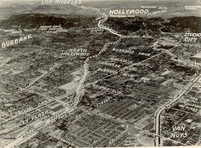
^*#North Hollywood-Toluca Lake Patch: History of the Laurel Canyon and Valley Plaza Mall; N. Hollywood Train Depot
#**California State Library Image Archive
#++Vintage Everyday: The 1938 Los Angeles Flood
#*#San-Fernando-Valley-Real-Estate.com: Granada Hills
#^#San Fernando Valley Blog: James Cagney Ranch
#^^*Facebook.com: Van Nuys Airport
#^#^Granada Hills North Neighborhood Council: Granada Hills History
**^^KCET: LA Flood of 1938: Cement the River's Future; When Cahuenga Pass Was Rustic; Los Angeles Pet Memorial Park
*^^^San Fernando Valley Historic Society/Facebook.com: La Reina Theater
*^*#Facebook.com: Classic Hollywood-Los Angeles-SFV
*^^#Flickr.com - Floyd B. Bariscale Photostream: Minnie Hill Palmer House
**^#LA Times Framework: Sepulveda Tunnel
^^**Pinterest.com: Stoney Pt. and Santa Susana Pass; Santa Susana Pass from Simi Valley
^^^*San Fernando Valley Relics - Facebook.com: Stoney Point; 1938 Flood; Van Norman Reservoir; Cypress Motor Motel
^^^#LA Observed: Dedication of theSepulveda Tunnel
^#**Los Angeles Fire Department Historical Archive
^#^*A Drifting Cowboy: The Grapes of Wrath
^#^^LAUSD.K12 - Lankershim Elementary School; Van Nuys Elementary School
^**#The Friends of Oakridge; theoakridgeestate.com
^*##Godickson.com: San Fernando Valley Map, 1930s
^*#*Pinterest - Memories I Remember Growing Up in the SFV
^##*Pinterest: Bygone Los Angeles
*##^City-Data.com: Santa Susana Pass
^##^Pinterest: San Fernando Valley
#*^#Google Maps and Street Views
#^*^Facebook.com: West San Fernando Valley Then And Now
##*^Calisphere: University of California Image Archive
*#^*Los Angeles County Library: History of Agriculture in the San Fernando Valley
*#^#Forum.skyscraperpage.com: Troquet Motel
***^Los Angeles Movie Palaces: Studio City Theater
*^ Wikipedia: Sherman Oaks; Isaac Van Nuys; Encino; Tarzana; Campo_de_Cahuenga; Cahuenga Pass; Chatsworth; Panorama City; Santa Susana Field Laboratory; North Hollywood; Canoga Park; Woodland Hills; Reseda; Orcutt Ranch; Granada Hills; Andrés Pico; Moses Sherman; Van Nuys; Henry Kaiser; Charles Maclay; San Fernando Valley; Mission Point; Hughes Aircraft; Domonique Amestoy; Winnetka, Los Angeles; City of San Fernando; Canoga Park High School; Ventura Freeway; Hollywood Freeway; Los Angeles Valley College; Chatsworth Community Church; Stoney Point; Minnie Hill Palmer House; Northridge; Iverson Movie Ranch; Van de Kamp's Holland Dutch Bakeries; Lower Van Norman Dam; Robert Morton Organ Co.; Van Nuys Airport; Simi Valley Freeway ;(118); Republic Pictures; Van Nuys Boulevard
< Back