Early Views of North Main Street
 |
|
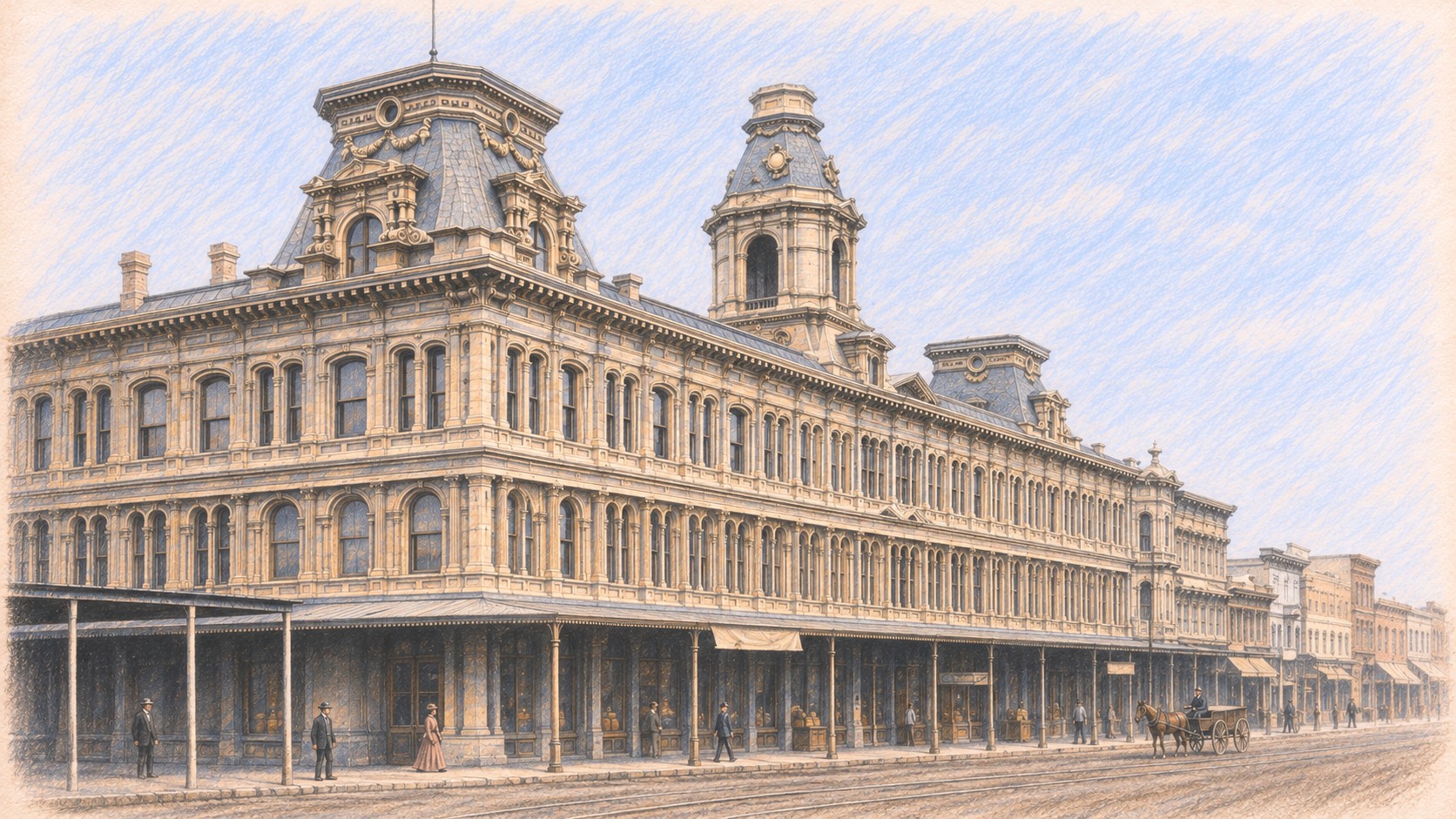
| An interpretive pastel sketch of the Baker Block on North Main Street, inspired by an 1880 photograph. |
Introduction |
Just south of the Los Angeles Plaza, North Main Street once brought together grand hotels, banking offices, storefronts, and the everyday bustle of a growing city. Horse-drawn stages and streetcars carried travelers past landmarks such as the Bella Union Hotel, the Pico Building, and the ornate Baker Block. Their changing surroundings traced Los Angeles’ emergence from a small pueblo into a busy commercial center.These photographs follow the street through decades of growth and change—from unpaved roads and early communication lines to crowded sidewalks, aging hotels, and eventual demolition. Before-and-after views reveal how street extensions, Civic Center development, and the Hollywood Freeway transformed this historic corridor, while surviving landmarks near the Plaza preserve a connection to its beginnings. |
* * * * * |
Main Street in the Early 1870s |
Hotels, Commerce, and Public Life Near the Plaza |
In the early 1870s, North Main Street linked the historic Plaza with the growing commercial district of Los Angeles. The Pico House, Merced Theatre, and Bella Union Hotel stood within a short walk of one another, serving travelers, theatergoers, merchants, and local residents. These three photographs look along the street in opposite directions, then show it as a gathering place for a Fourth of July celebration. |
Looking South from the Plaza
 |
|
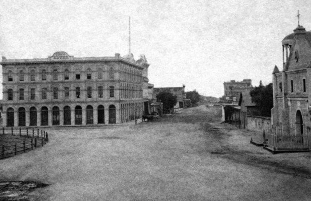
| (1872)* - Looking south along North Main Street from beside the Los Angeles Plaza. The Pico House stands in the left foreground, with the Merced Theatre just beyond it. In the distance, the Temple Block marks the commercial district near Main, Spring, and Temple streets, in the area later occupied by Los Angeles City Hall. |
Historical Notes The photographer stood near the Old Plaza Church, looking toward the business district south of the Plaza. Pío Pico, the last governor of Mexican California, commissioned the Pico House in 1869–1870. Designed by Ezra F. Kysor, it opened on June 9, 1870, as the first three story hotel in Los Angeles, with about eighty rooms, an interior courtyard, and a grand staircase. Its substantial façade contrasts with the unpaved roadway, revealing the investment transforming the old Plaza district. Kysor also designed the neighboring Merced Theatre, built in 1870 by cabinetmaker William Abbot and named for his wife, María Merced García. It was the first building in Los Angeles constructed expressly for theatrical purposes. Farther south, the Temple Block was associated with merchant Jonathan Temple and later his younger half brother, F. P. F. Temple. These buildings connected the historic Plaza with the expanding commercial district. |
Looking North Toward the Plaza
 |
|
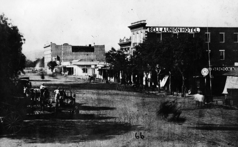
| (1870)* - Looking north along the unpaved roadway of Main Street through the historic 300 block. The Bella Union Hotel stands on the right, while the newly completed Pico House rises in the distance to the left, near the Los Angeles Plaza. |
Historical Notes This view reverses the direction of the preceding photograph. Although the Pico House appears left of center in the distance, both hotels stood on the east side of Main Street; their positions reflect the street’s bend toward the Plaza. The Bella Union was already a longstanding center of social and political life. Its early adobe structure was enlarged with a second story in 1851 and a third in 1869, illustrating how older buildings were adapted to serve a growing town. Immediately north of the Bella Union stood the Pico Building, another of Pío Pico’s investments on Main Street. Built in 1868, it housed Hellman, Temple and Company when that banking partnership opened that September. Farmers and Merchants Bank, established in 1871 by Isaias W. Hellman and John G. Downey, subsequently opened in the same quarters. The Pico Building and Pico House were separate projects, bringing banking facilities and hotel accommodations to different parts of the street. |
Main Street as a Public Gathering Place
 |
|
| (early 1870s)* - A Fourth of July parade on North Main Street, identified in archival descriptions as including veterans of the War of 1812. Men stand in two lines in the roadway, with horses, carriages, and spectators nearby. The Bella Union Hotel is partly hidden by trees in the background. |
Historical Notes The street itself becomes the focus of this photograph. Participants occupy the open roadway while spectators and carriages gather around them, showing how Main Street accommodated public ceremonies alongside everyday travel and business. Published sources differ on the date of the parade scene: the Los Angeles Public Library uses 1871, while PBS SoCal dates a Bella Union parade view to approximately 1873. The broader date used here reflects that uncertainty. The Bella Union was also a familiar setting for notable arrivals. On October 7, 1858, the first Butterfield Overland Mail stage from the east reached the hotel twenty-one days after leaving St. Louis. Warren Hall was the driver, and reporter Waterman Ormsby was the only through passenger. Later known as the Clarendon and then the St. Charles, the hotel continued to overlook the changing life of Main Street. Its site is California Historical Landmark No. 656. |
* * * * * |
Hotels and Shooting Galleries |
Lodging, Business, and Everyday Life Along Main Street |
By the late 1870s, Main Street’s hotels shared their surroundings with shops, offices, and places of entertainment. The St. Charles and Lafayette faced one another across a roadway busy with horses and carriages. These photographs bring the district into closer view, revealing the entrances, signs, and neighboring businesses that made it more than a place to spend the night. |
The St. Charles Hotel and Main Street’s Shooting Gallery
 |
|
| (1877)* - Looking across Main Street toward the St. Charles Hotel, formerly the Bella Union. Horses and wagons stand along the hotel frontage. In the right foreground, a man leans against a post beside a sign advertising “Rifle and Pistol Shooting.” |
Historical Notes The St. Charles was the old Bella Union under a new name. Renamed the Clarendon in 1873 and the St. Charles by early 1875, it continued operating as newer hotels competed for travelers. Its shaded frontage and waiting vehicles show the hotel’s close connection with the transportation and business activity of Main Street. |
 |
|
| (1877)* - A black-and-white version of the preceding photograph, showing the same St. Charles Hotel frontage, waiting vehicles, and “Rifle and Pistol Shooting” sign. |
Historical Notes The “Rifle and Pistol Shooting” sign advertised target shooting among the paid amusements available in the hotel district. Its position in the foreground, with the St. Charles across the roadway, helps establish the relationship between the two sides of Main Street. The following photograph turns toward the Lafayette Hotel and the neighboring businesses on the west side. |
Across the Street: The Lafayette Hotel
 |
|
| (1877)* – The Lafayette Hotel on the west side of Main Street, opposite the St. Charles. Tall windows, decorative pilasters, and a bracketed cornice distinguish its façade. At right, the “Rifle and Pistol Shooting” sign appears from another angle. |
Historical Notes The Lafayette dates to the 1850s and was an established part of the lodging district north of Temple Street by the 1860s. Its architectural details reflect the Italianate style that gave many nineteenth century commercial buildings their tall windows, ornamental trim, and strongly defined rooflines. Financial difficulties brought a change in ownership in 1878, when Doria Jones foreclosed on the property. Renovations followed, and in April 1879 the hotel reopened as the Cosmopolitan under Henry Hammel and Andrew H. Denker. It later became known as the St. Elmo. |
At the Lafayette’s Entrance
 |
|
| (ca. 1880)* - A closer view of the hotel building long known as the Lafayette, which reopened as the Cosmopolitan in 1879. Men gather near the entrance, and horses and carriages stand beside the unpaved street. An “Insurance and Real Estate” sign identifies another business along the frontage. |
Historical Notes If the photograph’s approximate date is correct, it shows the building during its early Cosmopolitan years. The Lafayette name identifies the property’s earlier history, while the new name marked an effort to refresh its accommodations and attract guests. Newspaper accounts of the 1879 reopening emphasized improvements to the dining room, staircase, and guest facilities. Outside, the waiting carriages, gathered men, and business signs show how a hotel entrance also served as a meeting place. Rooms and meals were available within, while the daily business of Main Street unfolded just beyond the doorway. |
Hotels and Banking Offices on the East Side
 |
|
| (1880)* - Looking northeast toward the St. Charles Hotel. Immediately to its left stands the two story Pico Building, the first home of Farmers and Merchants Bank. Farther north is the three story Perry-Riley Building, which housed the Grand Central Hotel. |
Historical Notes Pío Pico’s commercial building housed Hellman, Temple and Company when that banking partnership opened in September 1868. Farmers and Merchants Bank, established in 1871 by Isaias W. Hellman and John G. Downey, subsequently occupied the same quarters. By 1874, the bank had moved across Main Street into a building of its own, so the Pico Building was its former home when this photograph was taken. Farther north, the Perry-Riley Building was completed in 1874, with the Backman House hotel occupying its upper floors. Later known as the Grand Central Hotel, it added another substantial lodging establishment to the block. These neighboring buildings show how hotels, offices, and banks filled Main Street’s commercial frontage. The next section follows the street north to its most elaborate addition, the Baker Block. |
* * * * * |
 |
|
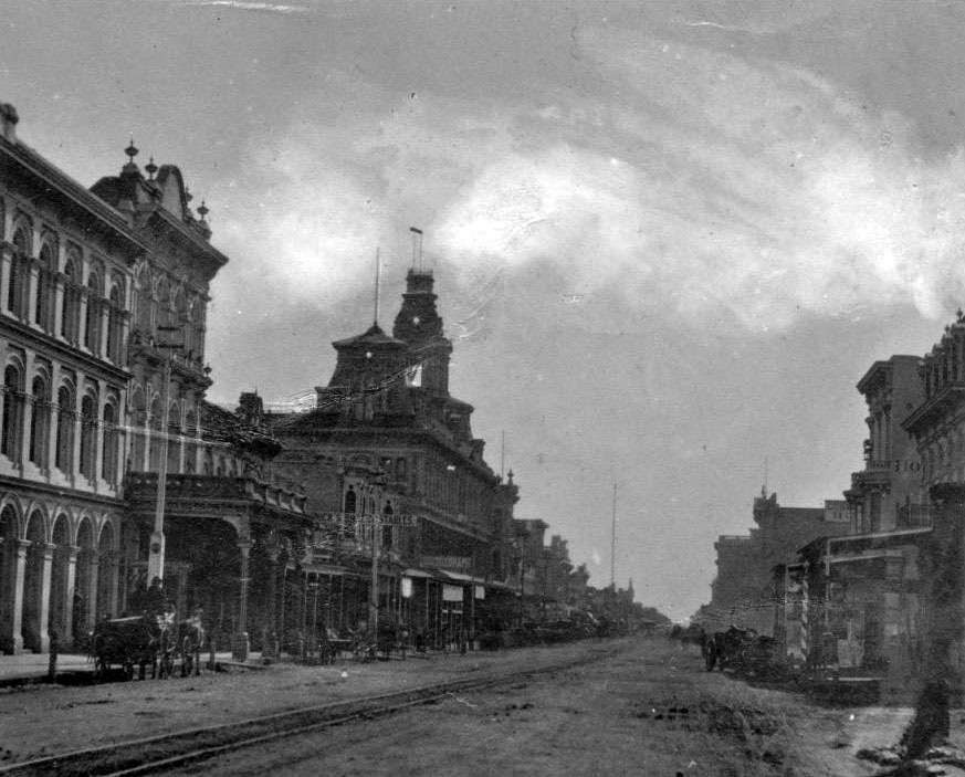
| (ca. 1878)* - View of Main Street looking south from near the LA Plaza. A horse-drawn wagon with two men in it is parked in front of the Pico House near the Merced Theater on the left. The road is unpaved and a streetcar track runs down the middle. Both sides of the street are lined with imposingly large buildings. At center, on the left side of the street, is an especially large building topped by three prominent towers. It is the Baker Building (referred to as Baker Block), built in 1878. |
Historical Notes The ornate three-story Baker Block was completed in 1878 by Colonel Robert S. Baker. It was located at the north end of the 300 Main St. block at the southeast corner of Main and Arcadia streets. For a number of years, the building housed offices, shops, and apartments. As a point of interest, Colonel Robert Baker married Abel Stearn’s widow, Arcadia Bandini de Stearns, in 1874 (three years after Stearn’s death in 1871). The Baker Block was built on the same site as the Stearns Adobe. |
 |
|
| (1880)* - Built on the former site of the Abel Stearns Adobe (S/E corner of Main and Arcadia streets) , the Baker Block was prominent in early Los Angeles. Note the telegraph office has a sign at the corner of the building. |
Historical Notes At the time of its completion, the Baker Block was reputedly the largest and most expensive structure to have been built south of San Francisco. Among other achievements, it is also believed to have been Los Angeles’ first steel-framed building, and it's first to have tiled floors. For many years it was considered the best thing in town, an early microcosm of city life. Offices for lawyers, physicians and businessmen were on the second floor and on the top floor were the City's most costly and fashionable apartments. |
 |
|
| (1880s)* - View looking southeast from Fort Hill, with the Baker Block seen on the southeast corner of Main and Commercial Streets. The Los Angeles River is visible in the distance at the upper left. Photo from the Ernest Marquez Collection. |
Historical Notes This elevated view was taken from the slope of Fort Hill, the site later occupied by the County Courthouse and Hall of Records. The Baker Block dominates the intersection of Main, Arcadia and Commercial Streets and was one of the most prominent commercial buildings in early Los Angeles. The Los Angeles River can be seen in the distance. Before flood control projects altered its course, the river flowed close to the early business district. The cluster of buildings between Main Street and the river shows how the commercial district was expanding during the late 1870s and early 1880s. This photograph illustrates the importance of the Baker Block and the businesses surrounding it, which together formed the core of the city’s commercial activity during this period. |
 |
|
| (ca. 1880)* - View of North Main Street showing (from L to R): Baker Block, Downey Building, Grand Central Hotel, Pico Building (original home of Farmers and Merchants Bank), and the St. Charles Hotel (formerly the Bella Union Hotel). |
Historical Notes The three-story Grand Central Hotel at 326 North Main Street was completed around 1877. Major construction came to its climax on the 300 blk of Main Street in the following year with the opening of the Baker Block, on the left. The slim, three-story building nestled between the Baker Block and Gand Central Hotel was developed by the ever active Governor Downey, and finished around 1878. |
 |
|
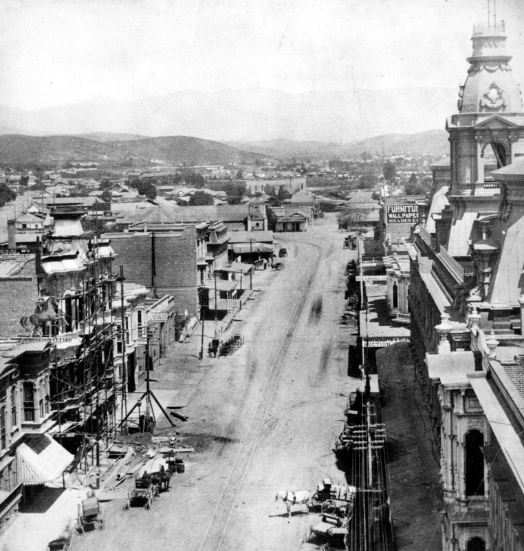
| (ca. 1880)* - View looking north on Main Street from the Downey Building located just south of the Baker Block on the 300 block of N. Main Street. In the distance can be seen the Old Plaza Church where Main Street veers to the left. Telephone/telgraph lines can be seen on both sides of the street. |
Historical Notes This photograph shows the early spread of telegraph and telephone lines along Main Street. In 1879, the Los Angeles Telephone Company was established, and Main Street became the center of the city’s growing communications network. The unpaved street, the streetcar rails and the horse-drawn vehicles reflect the transitional nature of downtown Los Angeles before widespread pavement and electric streetcars arrived in the 1880s. At the far end of the street, the Old Plaza Church marks where Main Street curves toward the Plaza. This is one of the earliest images to document Los Angeles’ adoption of modern communication systems. Alexander Graham Bell invented the telephone in the late 1870's and it didn't take long for Los Angeles to adopt the new technology. In 1879, the Los Angeles Telephone Company was formed and it began offering telephone service in the area of what is now Downtown Los Angeles. This was just one year after the very first North America telephone exchange was installed in New Haven, Connecticut (January, 1878). The Los Angeles Telephone Company originally started with only seven subscribers. |
 |
|
| (ca. 1880)* - View looking north on Main Street from the Downey Building located just south of the Baker Block on the 300 block of N. Main Street. In the distance can be seen the Old Plaza Church where Main Street veers to the left. Telephone/telgraph lines can be seen on both sides of the street. (AI image enhancement and colorization by Richard Holoff) |
Historical Notes This colorized view brings out details not easily seen in early photographs, including the contrast between the brick commercial buildings and the lighter toned adobe structures closer to the Plaza. The network of overhead wires shows how quickly telephone and telegraph lines were added to Main Street. Although enhanced, the original image records Los Angeles just before the population boom of the mid 1880s, when major improvements to streets, transit and buildings transformed the appearance of downtown. |
 |
|
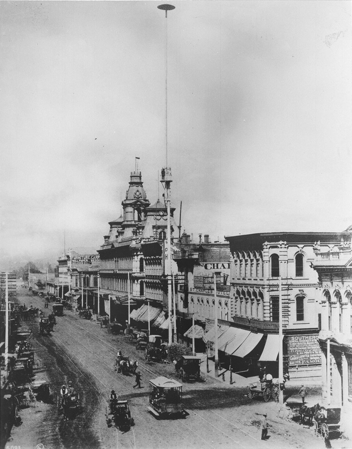
| (ca. 1882)**- Street view looking north showing the 300 block of N. Main Street. The Ducommun Building stands on the northeast corner of Main and Commercial streets at right. The tall pole at center is one of the City's first 150-ft tall electric light poles installed in 1882. A platform can be seen at what appears to be the top of the pole, however, it actually extends up another 75 feet. |
 |
|
| (ca. 1882)** - Another look at one of Los Angeles' first electric light poles. View is of the buildings on the east side of North Main Street from the Ducommun Building at Commercial Street (right) to the Baker Block at , at near right, to looking toward the Baker Block at . A man can be seen standing on a platform half way up the street light mast. Click HERE to see more in Early Los Angeles Street Lights |
 |
|
| (1883)* - View looking south on Main Street showing a group of men standing next to a horse-drawn wagon with two men seated on top. The Plaza is on the left (out of view). In the left background stands the Pico House and the Baker Block with its distinctive towers. There is a very tall pole seen between the two men on the wagon which appears to be a flagpole, but is not. It is a 150-foot tall electric street light mast that was one of the first to be installed in the City of Los Angeles. |
Historical Notes In 1882, C. L. Howland installed seven 150-foot tall streetlight masts, each carrying three carbon-arc lamps of three thousand candle-power. He also installed a small power plant to provide the electricity for his new street light system. The following year Howland and other investors would go on to form the Los Angeles Electric Company. It was the first electric utilty in Los Angeles. Click HERE to see more on LA's first electric streetlights. |
 |
|
| (1888)* – View looking north on the 300 block of Main Street, filled with horse-drawn streetcars, wagons, and a lone horseback rider. To the right are the ornate Baker Block, Downey Building, Grand Central Hotel, the two-story Pico Building, and the St. Charles Hotel (formerly the Bella Union Hotel). |
Historical Notes In 1888, the 300 block of North Main Street was a bustling hub at the heart of Los Angeles' commercial district, reflecting the city’s rapid transformation. Once considered the uptown commercial center, it featured a mix of hotels, banks, and other businesses, including the Farmers & Merchants Bank in the Pico Building, Los Angeles' first incorporated bank. Horse-drawn streetcars dominated the busy streets, while the introduction of telephones and telegraphs showcased the city’s embrace of new communication technologies. As the population surged from 11,183 in 1880 to 50,395 by 1890, the area became a focal point for expanding transportation networks and new neighborhoods, symbolizing Los Angeles’ shift from a small town to a thriving metropolis. |
 |
|
| (n.d.)* - Drawing of North Main Street, showing the location of the businesses in the entire 300 block, starting with the Baker Block on the left and extending to the Duccomun Building on the right. |
 |
|
| (ca. 1890)* – Looking south on Main Street with the Baker Block on the left, distinguished by its turrets. Pedestrians walk along the sidewalk, while horse-drawn carriages and a streetcar travel on the cobblestone street. |
 |
|
| (1898)*** - Postcard view of the 300 block of Main Street looking north on a clear day. Pedestrians are seen crossing the streetcar tracks on Main Street in front of the Ducommun Building. |
Historical Notes By the 1890s, as a result of the business center’s continuous southward expansion, North Main Street was beginning to fall into a long, slow decline. On the other hand, its tightly knit blocks were left largely untouched by new development while they continued to support active commercial uses. |
 |
|
| (ca. 1910s)* - View showing the Grand Central Hotel, at 326 N. Main Street, with businesses on the ground floor such as Tokyo Co. Inc. and Kwong Chow Cafe. A man in a push cart is directly in front. To the left ia the 3-story Downey Building and further to the left (out of view) is the Baker Block. To the right is the 2-story Pico Building. |
 |
|
| (1920s)* - View showing the east side of the 300 block of N. Main Street, north from the corner of Commercial Street. The Ducommun Building is seen at right with the 'Medical Offices' sign on its face and the St. Charles Hotel is at far left. Other business establishments seen in photo include the New Queen Restaurant, La Perla de Occidente Restaurant, a pool room, and clothing shops. |
 |
|
| (ca 1926)* – View showing several people crowded on the sidewalk in front of the St. Charles Hotel (old Bella Union Hotel) on N. Main Street. The New Queen Restaurant occupies the first floor of the hotel. |
Historical Notes Constructed in 1835, the Bella Union Hotel has a long, rich history. It served as the County Courthouse until October 1851, and in 1860 was the location of a champagne fete celebrating the connection of San Francisco and Los Angeles by telegraph. |
 |
|
| (1920s)* - View of a busy North Main Street in front of the Azteca Restaurant, El Restaurant Para Familias', as seen from across the street. The restaurant, which in previous photo was the New Queen Restaurant, is located on the street floor of the old Bella Union Hotel. A sign on the second floor reads: Office Room For Rent. |
 |
|
| (ca. 1930)* – View of the west side of North Main Street. Security First National Bank now occupies part of the Ducommun Building on the northeast corner of Main and Commercial streets. |
Historical Notes The Security First National Bank of Los Angeles became the Security Pacific National Bank and is now Bank of America. The Farmers and Merchants Bank was the oldest bank in Southern California from 1871 until 1956 when it was merged into the Security First National Bank of Los Angeles. |
 |
|
| (ca. 1930)* - Birdseye view looking north-east showing North Main Street as seen from City Hall. The large building in the foreground is the old Federal Building and Post Office (N/W corner of N. Main and Temple streets). The 300 block of Main Street is in clear view. |
.jpg) |
|
| (ca. 1930)* - Aerial view showing a closer look at the historic 300 block of North Main Street from Arcadia Street to Commercial Street. |
 |
|
| (1932)^*# - Postcard street view of North Main Street as seen from the base of Los Angeles City Hall at Temple Street. The entire 300 block of N. Main Street, from Baker Block to the Ducommun Building, can be seen here. The old Federal Building and Post Office stands on the northwest corner. |
 |
|
| (ca. 1936)* - Looking across N. Main Street (foreground) towards the French Second Empire style Baker Block, on the southeast corner at Arcadia Street (lower left), and the Grand Central Hotel (right). Between the two sits a very narrow Doheny Building. |
Historical Notes The Baker Block had lost much of its luster by the turn of the century, and by the time it was purchased by Goodwill Industries in 1919, it was all too clear that its days were numbered. As cruel fate would have it, the faded landmark was slated to give way to one of the most mundane projects in the 1930 Civic Center plan: a two-block extension of Aliso Street from Los Angeles Street to Broadway. Despite plans to relocate the structure for another purpose, the city purchased the Baker Block from Goodwill in 1941 and demolished the building a year later. U.S. Route 101 now runs beneath where these buildings once stood. |
 |
|
| (ca. 1940)* - Looking northeast showing the buildings on the 300 block of North Main Street shortly before their demoliton. |
Historical Notes Well into the 20th century, the old buildings on the 300 block of North Main Street were a vivid testament to Los Angeles’ early history, from its humble beginnings to its astonishing growth during the Reconstruction years. Behind the “Azteca” sign on the right side of the top photograph is the Bella Union Hotel, considered to be the city’s first hotel. Completed sometime during the 1840s, it was one of downtown’s greatest landmarks for several decades, and was later expanded to two, then three stories. The two-story building to its left is the Pico Building, built by Pio Pico in 1868 (two years before the Pico House). In 1871, the building became home to the Farmers & Merchants Bank, the first incorporated bank in the Los Angeles, directed by former California Governor John G. Downey. |
 |
|
| (ca. 1949)*- View of the 300 block of North Main Street, just north of Commercial Street, showing (L to R): the slim, ornate Downey Building, the Grand Central Hotel, and the Pico Building (original home of Farmers and Merchants Bank). At the lower center-right, two rival cafes, the California Cafe and the Arizona Cafe, stand side by side—proving even eateries from neighboring states can get along... at least until lunchtime rush!". |
Historical Notes The Baker Block is missing in the image above. This prominent structure, built in 1878, was demolished in 1942. It had been one of the most impressive buildings of its time, known for its ornate French Second Empire architecture. |
 |
|
| (ca. 1949)* - Main Street, looking northeast at Commercial Street with the Ducommun Block and Security First National Bank on corner. Photo by Arnold Hylen |
.jpg) |
|
| (ca. 1950)* - View showing the last building standing on the 300 block of North Main Street awaiting demolition. It is the slim, three-story Downey Building (built in 1878) that once was nestled between the Baker Block and Grand Central Hotel. |
 |
|
| (ca. 1950)* - View looking east showing the Downey Building at 330 N. Main Street before its demise. |
Before and After
 |
|
| (ca. 1930)* - View looking northeast from City Hall showing the old part of Los Angeles including the LA Plaza and Chinatown. At left can be seen the ornate Baker Building with its three towers located on the historic 300 block of N. Main Street. Los Angeles Street runs diagonally from lower-right to upper-left. Aliso Street runs from Los Angeles Street at center east and then turns diagonally up. Union Station wasn't completed until 1938 and would be located in the upper right of photo. |
Historical Notes The historic buildings on the 300 block of North Main were demolished to extend Aliso Street from Los Angeles Street to Broadway. Several years later the Hollywood Freeway (Route 101) would be constructed over this new Aliso Street extension. |
 |
|
| (ca. 1951)* - Aerial view of Los Angeles near the Plaza before construction of the Hollywood Freeway with Union Station in the background. The Plaza is seen to the left. The 300 block of North Main Street is at lower left, now consisting of mostly parking lots and the new Aliso Street extension. |
 |
|
| (1950s)^^ - Construction of the 101 Freeway begins through the old section of Los Angeles along Aliso Street. The LA Plaza is seen at left-center and the historic 300 block of Main Street at lower left corner. |
Historical Notes The Hollywood Freeway (U.S. Route 101) through downtown Los Angeles was opened in 1954. |
 |
|
| (1970s)* - View from City Hall looking down toward the 300 block of North Main Street. The Hollywood Freeway (U.S. Route 101) now runs beneath where the Main Street historic buildings once stood. |
Then and Now
 |
|
| (1880s vs 2023)* - Looking southeast from Fort Moore Hill, the ornate Baker Block once stood on the southeast corner of Main and Arcadia Streets. Today, the 101 Freeway runs beneath the site of this historic building. Photo comparison by Jack Feldman. |
Historical Notes The Baker Block, constructed in 1878 by Colonel Robert S. Baker, was one of the grandest commercial buildings of its era, featuring a striking French Second Empire design and an early use of steel framing. It housed high-end apartments, shops, and offices and was once considered the finest building south of San Francisco. By 1942, the building had been demolished to make way for the US 101 Freeway, which now runs beneath the site, erasing a cornerstone of early downtown Los Angeles. |
Then and Now
 |
|
| (1935 vs 2022)* - Looking down toward Union Station from the top of City Hall. Note the Hollywood Freeway runs through where the Baker Block once stood (lower-left). Photo comparison by Jack Feldman. |
Historical Notes The 1935 photo shows the Los Angeles Plaza area in transition, as the old neighborhood was being cleared to build Union Station, which opened in 1939. In the lower left, the Baker Block stood shortly before its demolition for the Hollywood Freeway. This view highlights how rail and highway projects of the mid-20th century dramatically reshaped the city’s historic core. |
Main Street Through the Years: Then and Now
.jpg) |
|
 |
|
| (1930s vs 2015)* - View of N. Main Street as seen from about the same spot over 70 years later. Photo comparison by Jack Feldman. |
Historical Notes In the 1930s, North Main Street retained much of its 19th-century character, with commercial storefronts and historic hotels like the Bella Union still in place. By 2015, modern infrastructure and redevelopment had stripped away nearly all of the original streetscape, leaving only fragments of early Los Angeles visible near the Plaza. |
Then and Now
 |
|
| (1880 vs 2022)* - Looking north on the 300 Block of Main Street. Photo comparison by Jack Feldman. |
Historical Notes The 300 block of Main Street once featured some of Los Angeles’ most important early buildings, including the Bella Union Hotel and the Pico Building, which housed the Farmers and Merchants Bank. This stretch of Main was the city’s commercial heart in the late 1800s. Today, none of the original buildings remain, replaced by civic infrastructure and widened roadways. |
* * * * * |
Main Street Through the Years: Then and Now
 |
|
| (1870 vs 2022)* – Looking north on Main Street from Aliso Street in Old Downtown Los Angeles. Homeless tents line the sidewalks in the 2022 view, a stark contrast to the open dirt road of 1870. Photo comparison by Jack Feldman. |
Historical Notes This “Then and Now” comparison shows Main Street as it appeared in 1870 (top) and in 2022 (bottom). The 1870 photo captures a dirt road leading north toward the recently completed Pico House, barely visible across from the Los Angeles Plaza. To the right stands the Bella Union Hotel, a prominent landmark of early Los Angeles. By 2022, the historic streetscape had changed dramatically—most of the buildings on this stretch were demolished in the 1950s for the 101 Freeway, which now runs beneath the Main Street overpass. In the modern view, homeless encampments line the sidewalks, reflecting Los Angeles’ ongoing challenges with housing and public space. The prominent brick building in the frame is the Merced Theatre, partially obscuring the Pico House from this angle. |
 |
|
| (1870 vs. 2025)* – Main Street looking north from Aliso Street in Old Downtown Los Angeles. The 2025 view shows the sidewalks clear of tents, offering a cleaner and more open public space. Photo comparison by Jack Feldman. |
Historical Notes This updated comparison revisits the same vantage point as the 2022 image. By 2025, the homeless tents previously lining Main Street have been removed, restoring a sense of openness to this historic corridor. Whether through city outreach efforts, service programs, or encampment relocation, the area now offers a clearer view of the surviving landmarks, including the Merced Theatre and the Pico House in the distance. While it’s uncertain if this improvement will endure, the contrast between 2022 and 2025 underscores the city’s ongoing struggle—and hope—to balance historic preservation, urban life, and humanitarian challenges. |
Then and Now
 |
|
| (1872 vs 2021)* – Looking south on Main Street from in front of the LA Plaza. Three buildings still exist today: The Pico House and the Merced Theatre on the left, and the Plaza Church on the right. In the distance of the early photo can be seen the Temple Block, current site of Los Angeles City Hall. Photo courtesy of Mark Frazier. |
Historical Notes The 1872 photo shows three historic landmarks still standing today: the Pico House and Merced Theatre on the left, and the Plaza Church on the right. In the distance, the Temple Block marked the commercial hub of the early city and would later be replaced by City Hall. This pairing highlights how rare it is for 19th-century structures to survive in downtown Los Angeles. |
Then and Now
 |
|
| (1883 vs. 2021)* – A ‘Then and Now’ view looking south on Main Street from in front of the Los Angeles Plaza with the Pico House on the left. Photo comparison by Jack Feldman. |
Historical Notes In 1883, Main Street around the Plaza was still the city’s social and commercial center, with the Pico House and Merced Theatre dominating the view. By 2021, the Plaza area remains one of the few places where these early structures coexist with the modern civic skyline, offering a direct link to Los Angeles’ pre-railroad past. |
 |
|
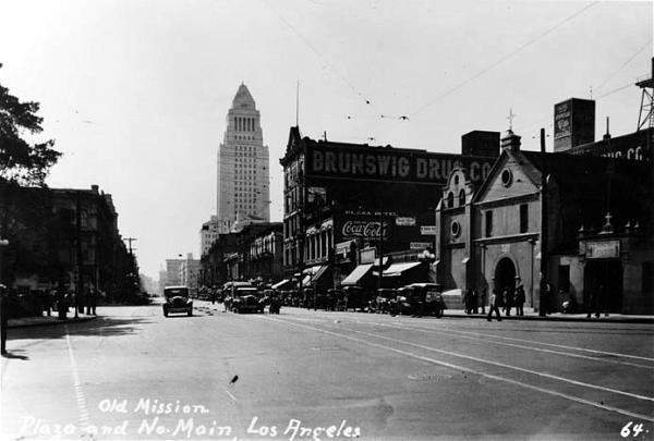
| (ca. 1928)* - View looking south on Main Street showing the newly constructed City Hall standing in the background (corner of Temple and Main streets) with the Brunswig Building and Old Plaza Church at right. |
Historical Notes This 1928 image captures the newly completed Los Angeles City Hall in the distance, rising above the Temple and Main Street intersection. On the right are the Brunswig Building and Old Plaza Church, both of which date back to the late 19th century. This was a pivotal moment as City Hall became the focal point of the growing metropolis. |
 |
|
| (2021)* - Contemporary view looking south on Main Street from in front of the Los Angeles Plaza, with the Old Plaza Church visible on the right. Notable buildings from left to right include the Pico House, City Hall East, City Hall, the Federal Courthouse, the Vickrey/Brunswig Building, and the Plaza House. |
Historical Notes The modern view from in front of the Plaza shows how downtown Los Angeles has evolved while still preserving key historic buildings. From left to right, the Pico House, City Hall East, City Hall, the Federal Courthouse, the Vickrey/Brunswig Building, and the Plaza House frame the street. The contrast between 19th-century brick structures and 20th-century civic towers reflects over 150 years of city growth. |
Then and Now
 |
|
| (1928 vs. 2021)* – Looking south on Main Street from in front of the Los Angeles Plaza, with the Old Plaza Church visible on the right. Most of the buildings seen in the 1928 photo still stand today. The only additions visible in the contemporary photo are the Federal Courthouse (1940) and City Hall East (1969). Photo comparison by Jack Feldman. |
Historical Notes The 1928 photo, taken just after City Hall’s completion, shows how much of the Plaza-area architecture remains intact today. The Old Plaza Church, Pico House, Vickrey/Brunswig Building, and Plaza House are still standing, though newer additions like the Federal Courthouse (1940) and City Hall East (1969) now dominate the skyline. |
Research, writing, and image curation by Jack Feldman, Water and Power Associates, with editorial assistance.
* * * * * |
More Historical Early Views
Newest Additions
Early LA Buildings and City Views
History of Water and Electricity in Los Angeles
* * * * * |
References and Credits
* LA Public Library Image Archive
** DWP - LA Public Library Image Archive
++Vigilantism in Los Angeles (1853 - 1874)
***Photos of Vintage Los Angeles: Facebook.com
*^*California Historical Landmarks Listing (Los Angeles)
^*^Urban Diachrony: East side of North Main Street south of Arcadia Street
^*#California State Library Image Archive
*^ Wikipedia: Farmers and Merchants Bank of Los Angeles; Isaias Wolf Hellman
< Back