Early Views of Santa Monica
Historical Photos of Early Santa Monica |
 |
|
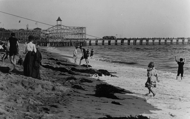
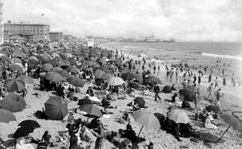
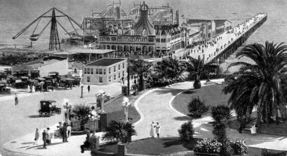
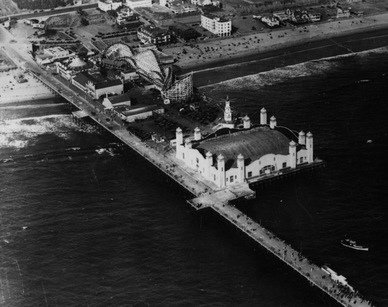
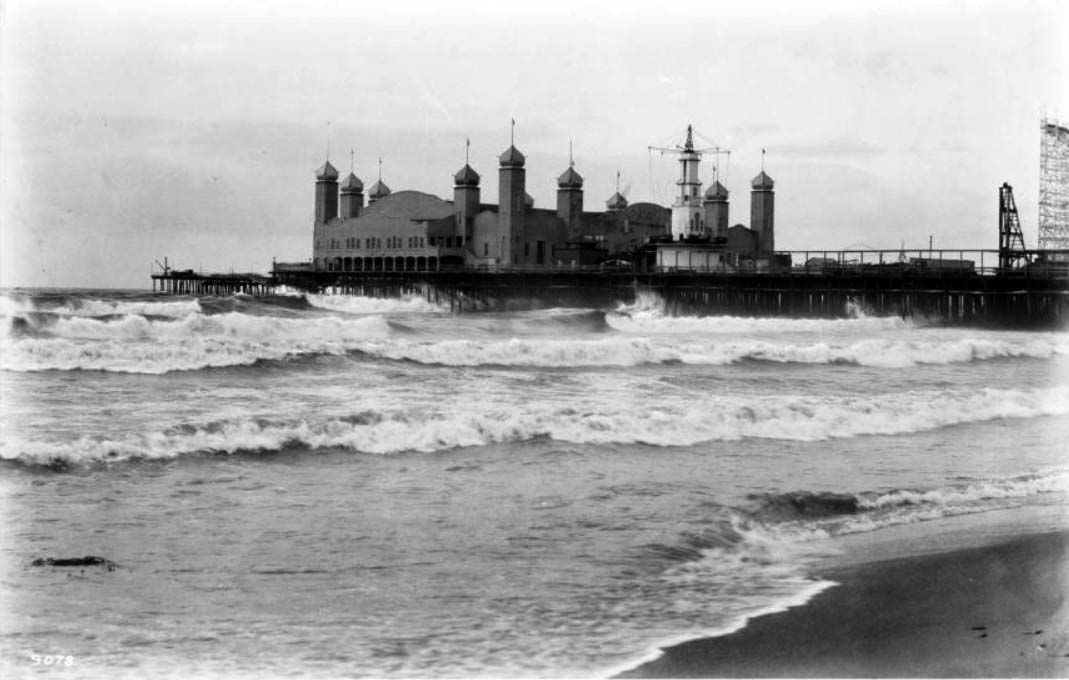
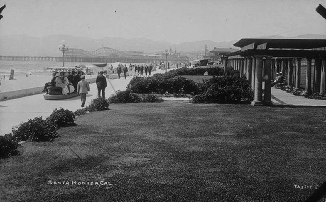
| (1912)* - View of the seashore at Ocean Park Beach in Santa Monica. Amusement park can be seen on the pier. The roller coaster seen above was called Ingersol's Scenic Railroad. It was the first roller coaster to be installed in the Santa Monica Bay area. |
Historical Notes Amusement piers became enormously popular in the first decades of the 20th century. The extensive Pacific Electric Railroad easily transported to the beaches people from across the Greater Los Angeles Area. Competing pier owners commissioned ever larger roller coaster rides. Wooden piers turned out to be readily flammable, but even destroyed piers were soon replaced. There were five piers in Santa Monica alone, with several more down the coast. |
 |
|
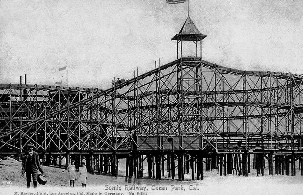
| (ca. 1912)* – Postcard view showing a man and two young girls walking along the beach with the Ocean Park Scenic Railway Roller Coaster in the background. |
Historical Notes In 1904, Ingersol's Scenic Railroad was the first roller coaster to be installed in the Venice / Ocean Park area. |
 |
|
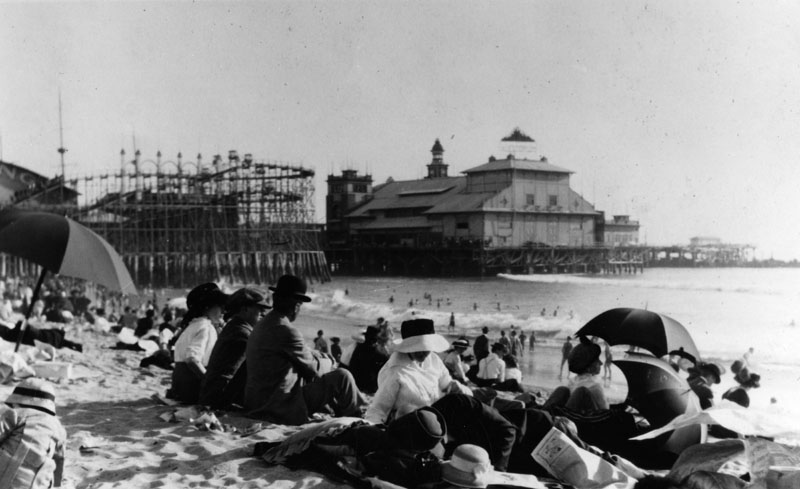
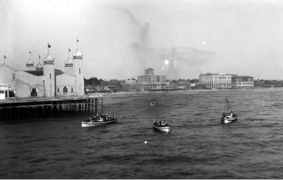
| (1912)* - View from Santa Monica Beach of Ocean Park. |
Historical Notes The earliest part of the current Santa Monica Pier, which is now the last remaining amusement pier, was built in 1909 on what was referred to as the North Bay. The second half, an amusement park pier, was built later and the two rival piers were merged. |
 |
|
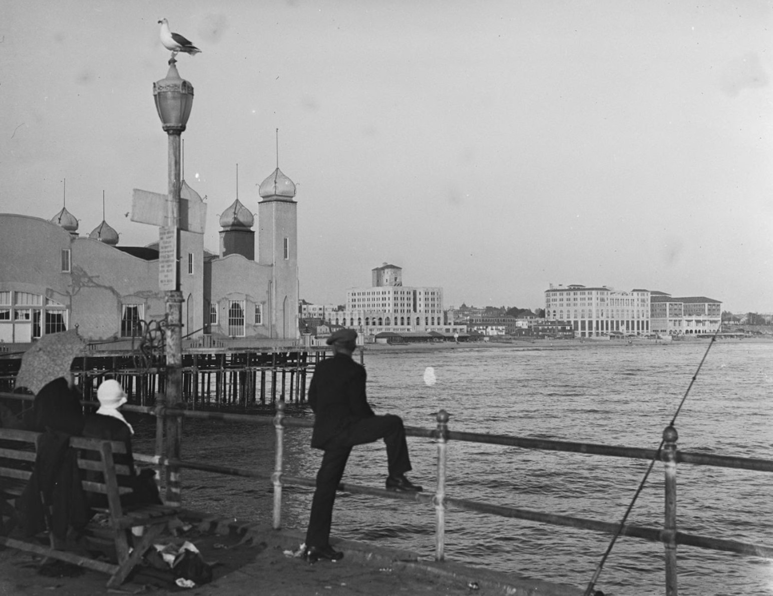
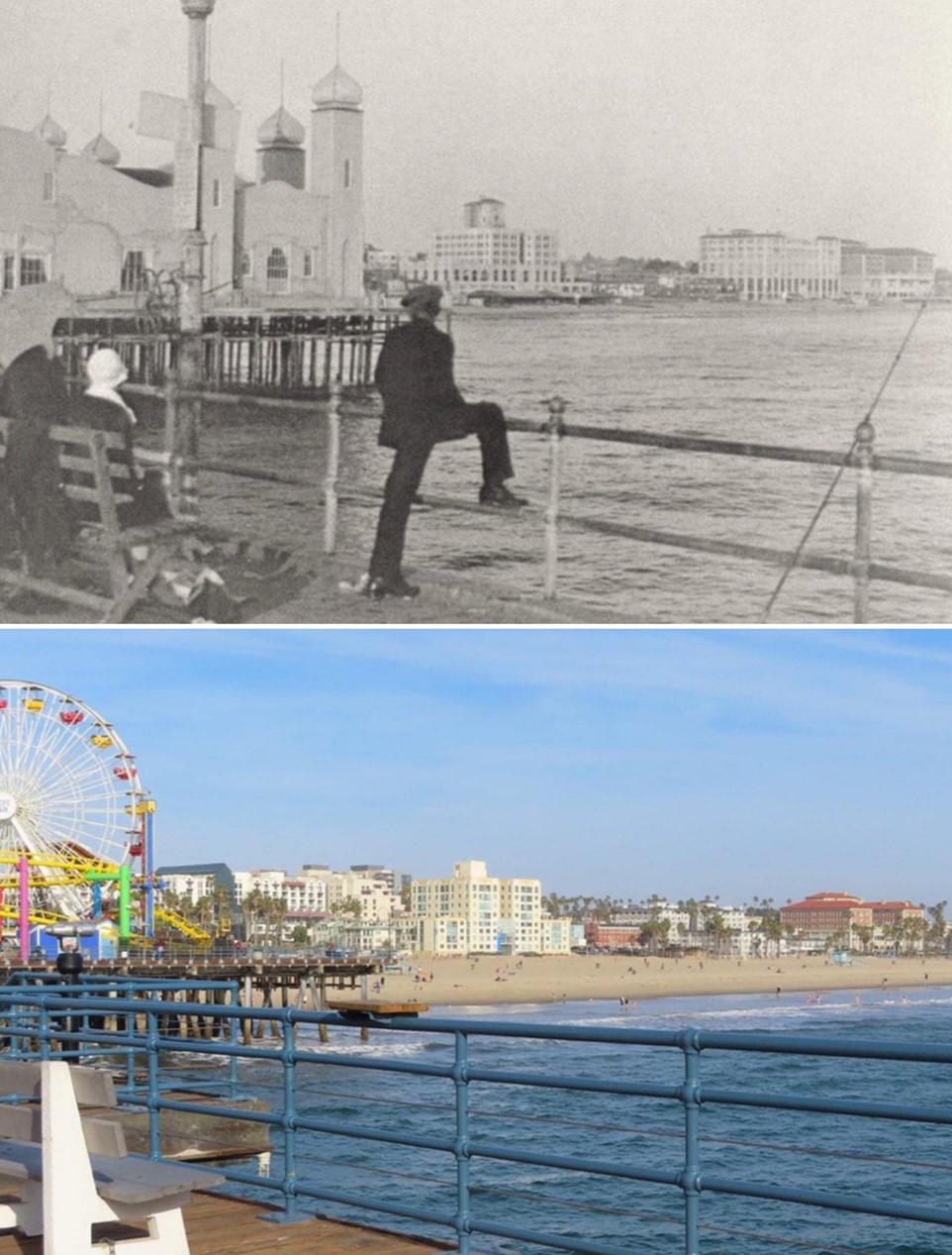
| (ca. 1910)* – Waiting for a Bite, Ocean Park – Several people are seen leaning on railings and fishing from Ocean Park Pier. One man is holding a bamboo (cane) fishing rod. Sign on the building in the background reads: "Roof Garden Now Open". |
 |
|
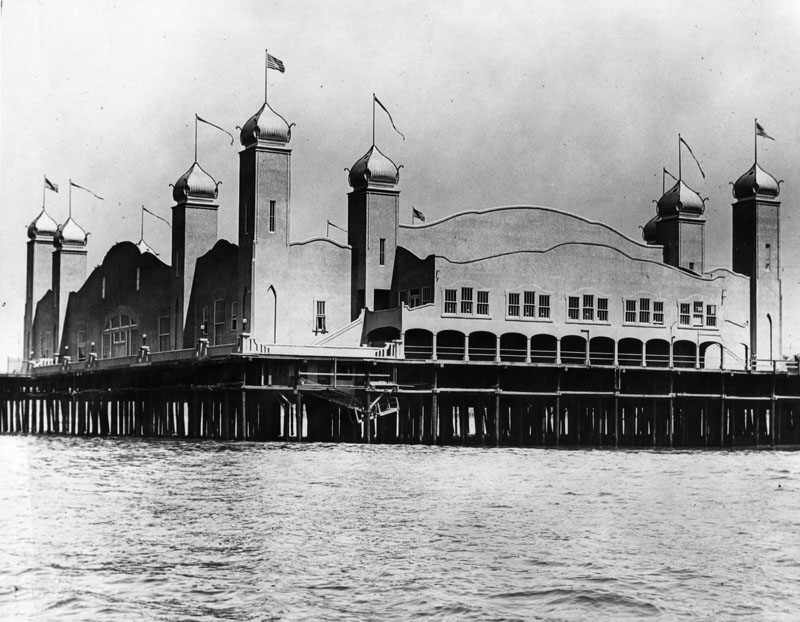
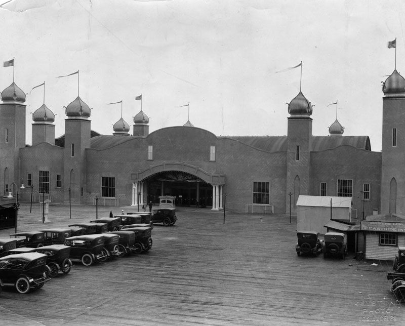
| (ca. 1910)* - View of the casino and band stand at Ocean Park in Santa Monica. The two-story brick building is at center. It has a wooden ramp leading up from the sandy beach to the entryway at center. The roof of the building is flat and has an open observation deck. Four towers are visible, one on each corner, and a sign over the arched entryway identifies the building as a casino. A man is standing near the entrance, and another is visible in the foreground at right. Several benches can be seen in the sand in front of the casino, and American flags fly from the top of the building. |
 |
|
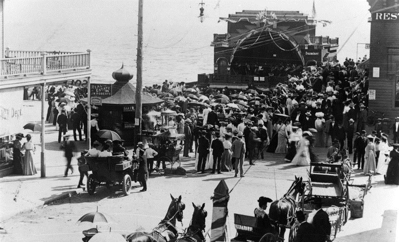
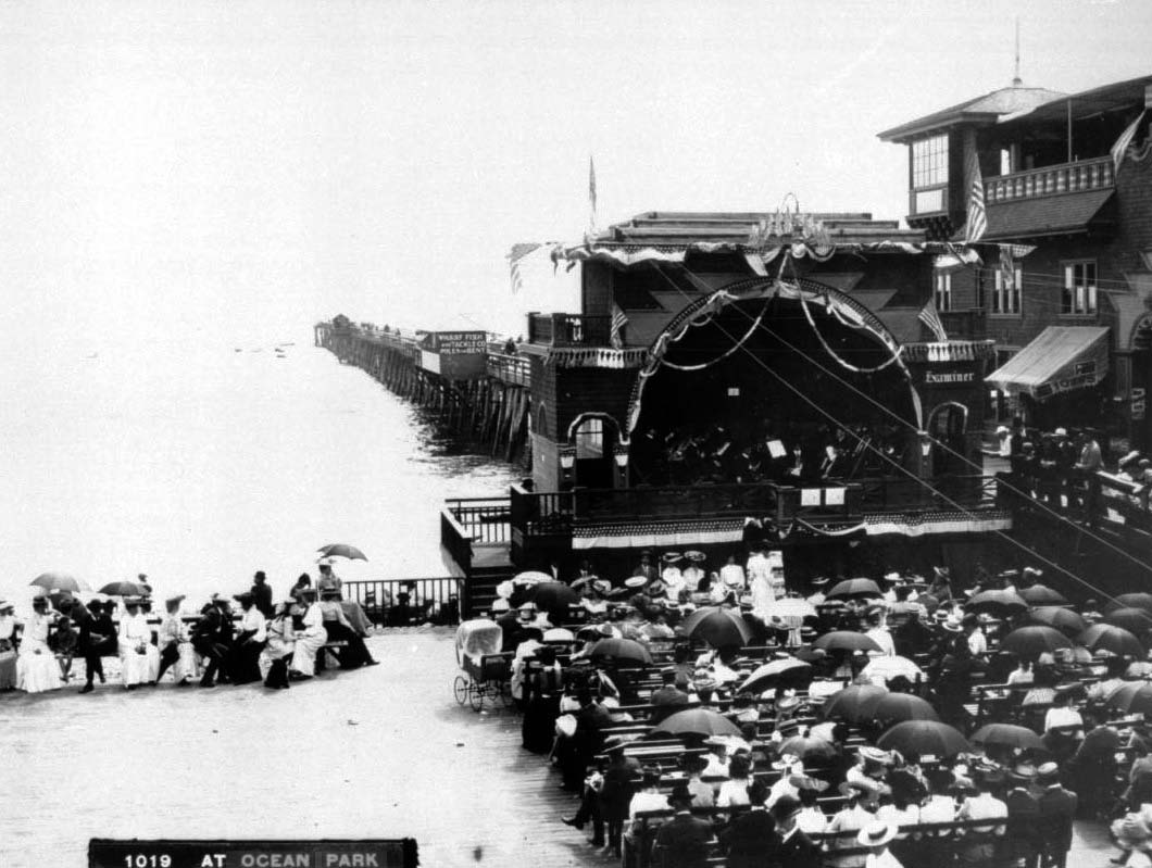
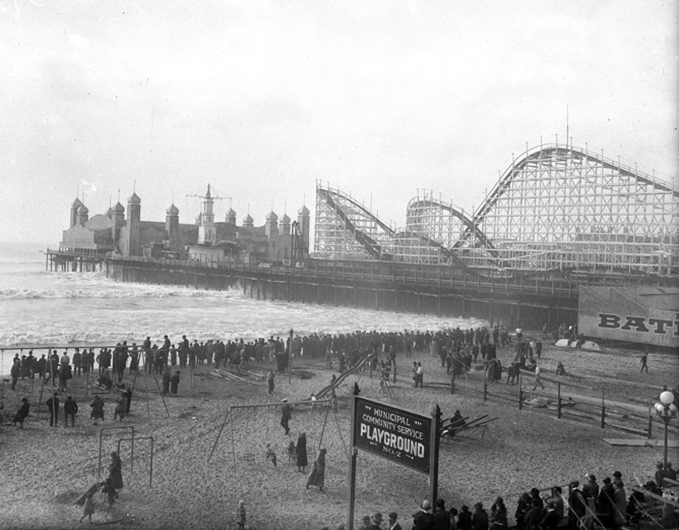
| (1912)* - Large crowds are gathered near a concert shell in Ocean park. There are more people than seats. Edges of buildings of several businesses can also be seen such as real estate and restaurants. An early model car and several horse-drawn wagons are parked in the foreground. |
 |
|
| (ca. 1910)* - Closer view of the Ocean Park bandstand showing Harry Moore's band playing in front of a crowd. Dozens of people, many holding umbrellas, are seated in chairs in front of the band, watching. Attached to the bandstand at right is a casino, and a pier juts into the water behind the bandstand building. More people can be seen seated on benches at left near the water's edge. A small shack on the edge of the pier is adorned with the words "Wharf Fish and Tackle Co. Poles for Rent". |
 |
|
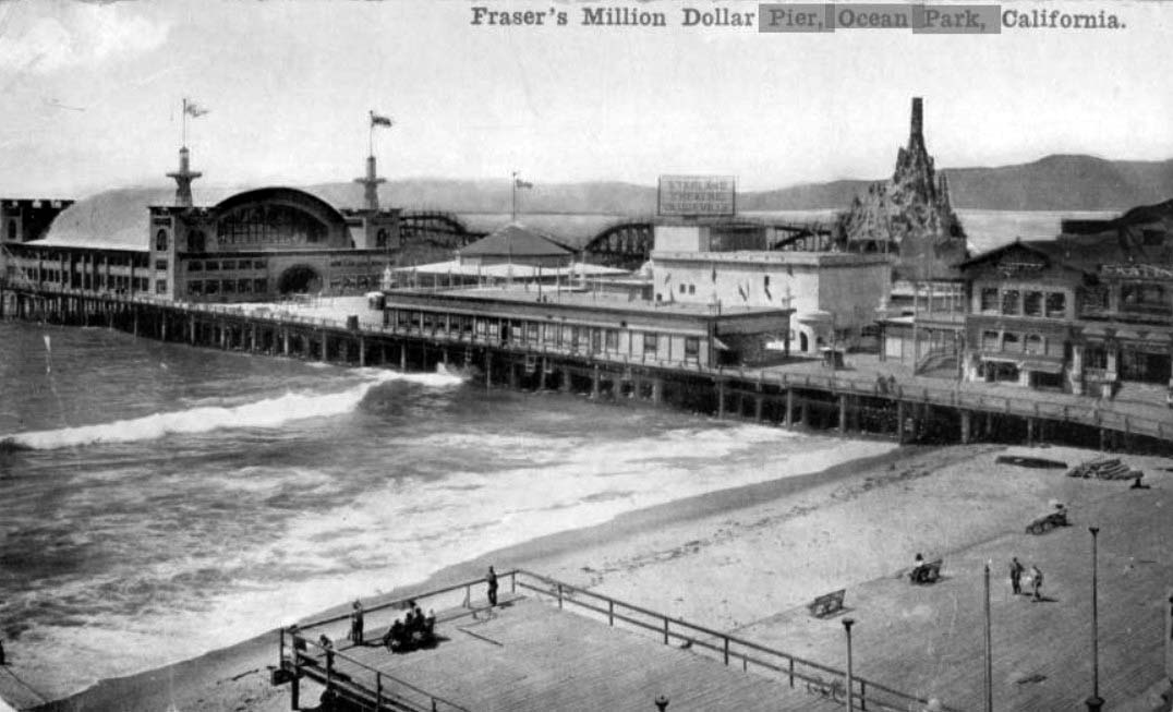
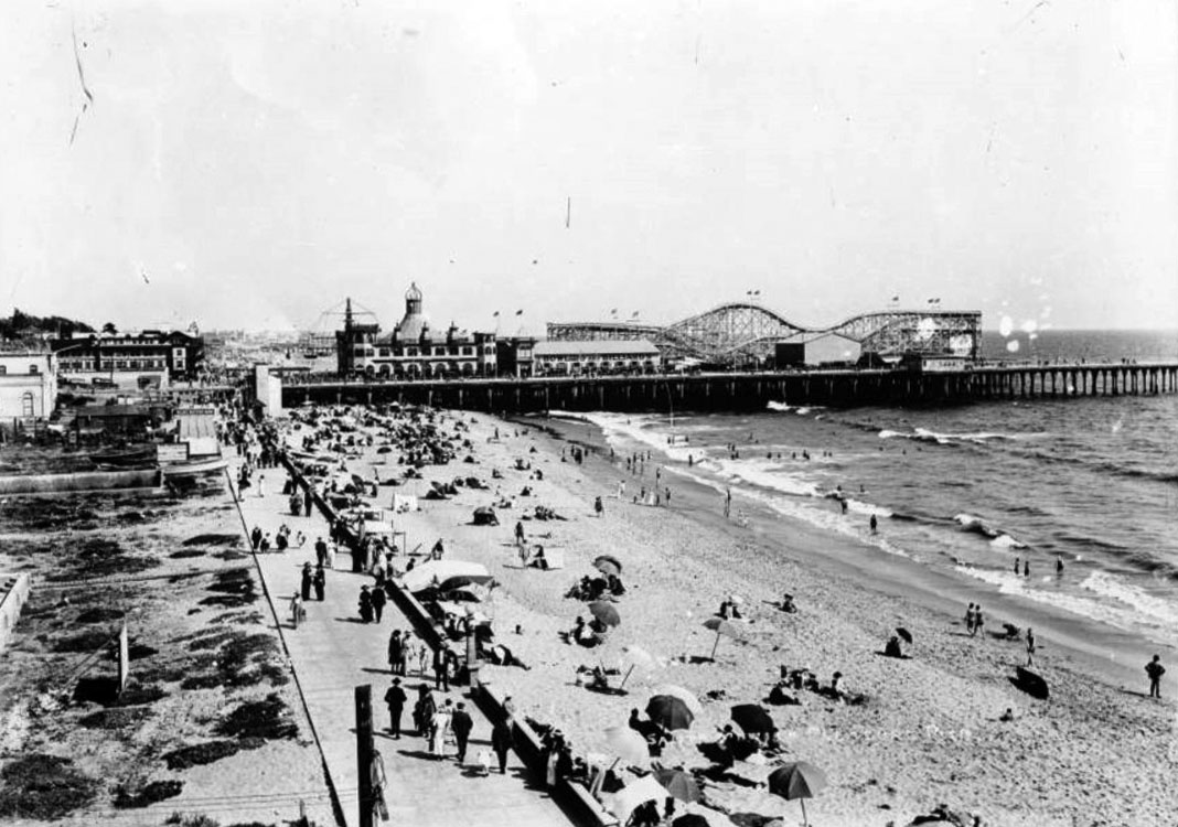
| (ca. 1911)* – Postcard view showing Fraser's Million Dollar Pier, Ocean Park. Fraser's Dance hall, the roller coaster, and Starland Theater can be seen on the pier, with a boardwalk and beach in the foreground. |
 |
|
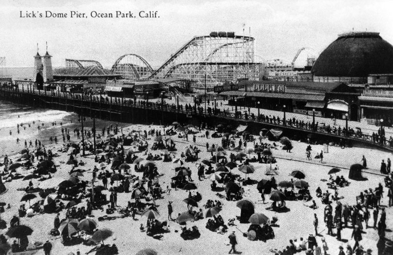
| (ca. 1911)* - View of the Lick's Dome Pier at Ocean Park. |
Historical Notes In 1911, Charles Lick added Lick Pier to the new Million Dollar Pier. They were both destroyed by fire in 1912 and again in 1924. The Lick Pier was rebuilt both times. The pier was finally done in by a fire in 1970, after which it was not rebuilt. |
 |
|
| (Early 1900s)^^ - A crowded day at the Ocean Park Pier in Santa Monica. |
Historical Notes The Ocean Park Pier, a combination of two piers: Million Dollar Pier and Lick Pier, burned down in 1912. In its place was rebuilt Fraser's Million Dollar amusement pier, which claimed to be the largest in the world at 1250 feet long and 300 feet wide. The pier housed a spacious dance hall, two carousels, the Crooked House fun house, the Grand Electric Railroad, the Starland Vaudeville Theater, Breaker's Restaurant and a Panama Canal model exhibit. It too burned within the year. |
 |
|
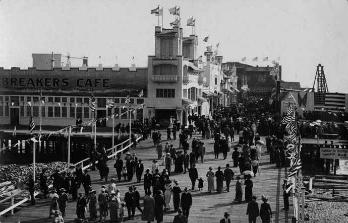
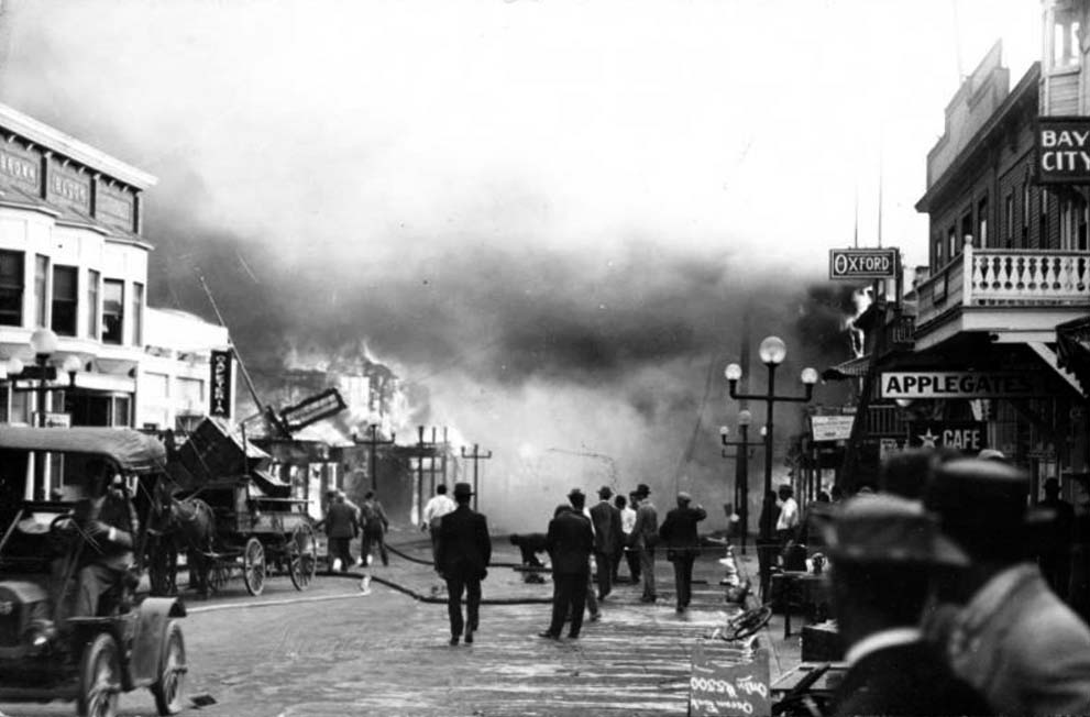
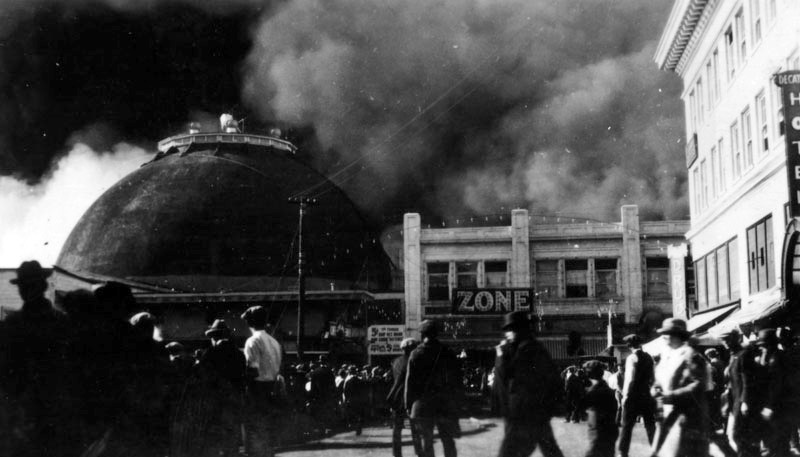
| (1912)- View showing people working to extinguish the fire on the Ocean Park pier in Santa Monica, 1912. The fire is blazing in the distance at left. A group of onlookers is gathered at center as is watching as firemen drag a large hose towards the building. The dirt road at center is muddy from the water used to fight the fire. An early automobile can be seen at left, and a large horse-drawn wagon is parked near the edge of the street at left. A collection of two-story buildings lines the road.; Legible signs include, from left to right: "Brown Block", "Cafeteria", "Oxford", "Applegate's Café", and "Bay City". |
Historical Notes Click HERE to see more Early Southern California Amusement Parks. |
* * * * * |
Bristol Pier (originally White Star Pier, later Crystal Pier)
 |
|
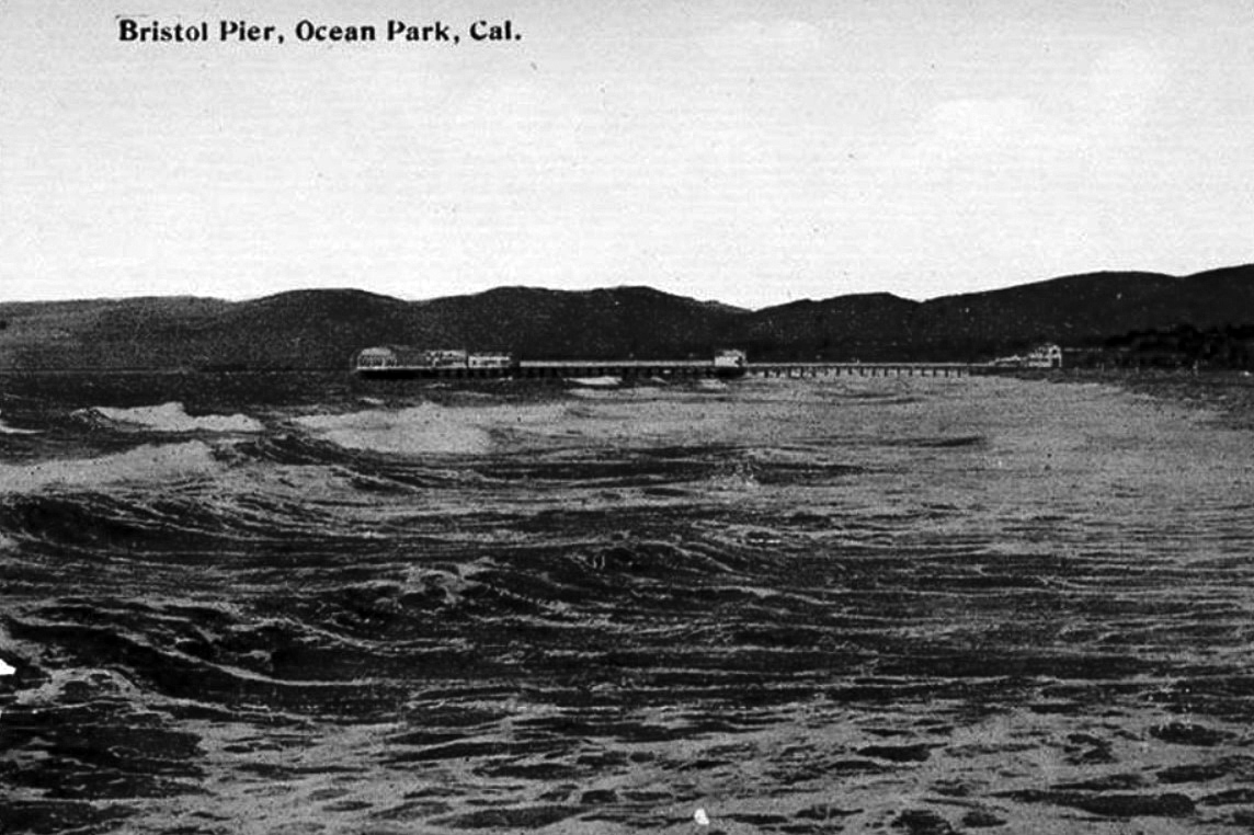
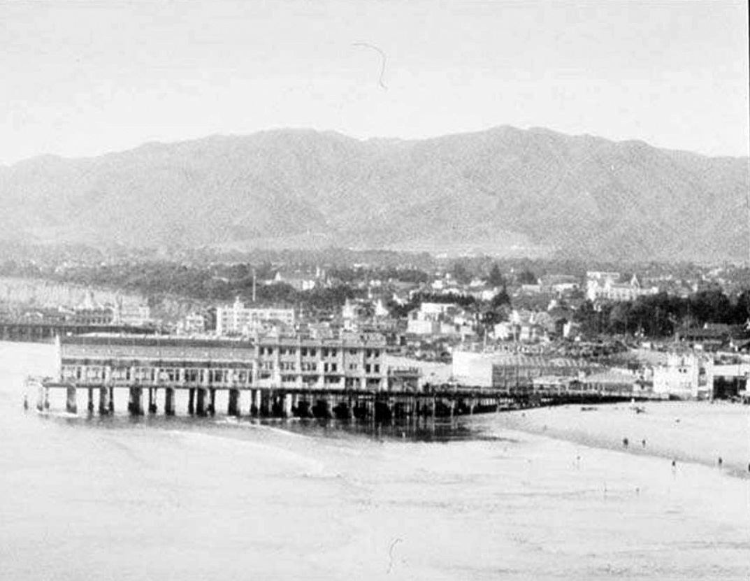
| (ca. 1908)* – View looking north from Ocean Park Pier showing Bristol Pier in the distance. |
Historical Notes The smallest pier, south of Santa Monica Pier at Hollister Avenue, existed from 1905 to 1949. It was built in 1905 as the White Star. In 1908 it was renamed the Bristol Pier. From 1919 to 1949 it was the Crystal Pier. The pier was demolished in 1949. |
 |
|
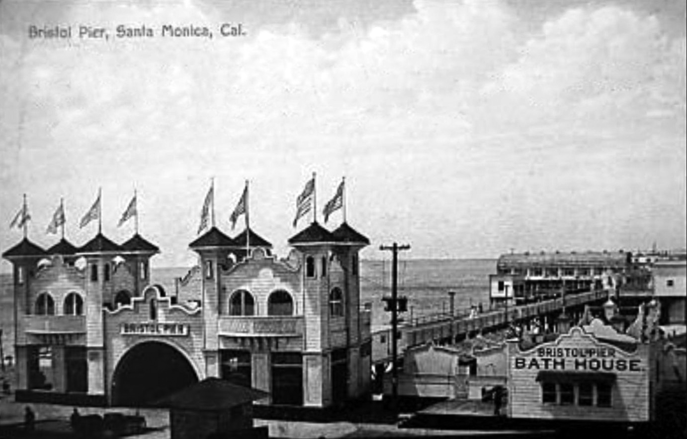
| (1908)* – Postcard view showing the Bristol Pier located in Ocean Park (Santa Monica) at the foot of Hollister Avenue. |
Historical Notes The White Star pier was completed in 1905, but it was not a paying investment during its first season and was sold in 1906. Renamed the Bristol pier in 1908, and the Crystal Pier in 1919 by Nat Goodwin. |
 |
|
| (1909)* – Postcard view showing the flags rising from the ornate entrance to Bristol Pier in Ocean Park* with the Bristol Pier Bath House seen at lower-right. |
Historical Notes Although Santa Monica and Ocean Park (South Santa Monica) were both settled at the same time (in the early 1870’s), Ocean Park’s history is somewhat independent from that of the rest of Santa Monica. Separated from the north by a gully which today is occupied by the Santa Monica Freeway, Ocean Park was initially oriented towards the beach where a series of piers and other tourist attractions were erected in 1890 to 1910. Much of the housing during this initial period of development was deliberately temporary in nature. Although residential tracts began to be subdivided from the large blocks of land owned by families such as the Lucas’ and the Vawters, construction tended to cluster on streets nearest the ocean, with the 4th Street hill as the inland boundary. One of the city’s oldest neighborhoods, Ocean Park sprang to life with Abott Kinney’s 1891 Ocean Park Development Company. Kinney bought a sandy strip of land in Santa Monica’s southwestern edge and began building roads, homes, parks and piers. After 1904, Kinney moved his attention to his Venice of America development (also called Ocean Park at the time) , south of the Santa Monica city boundary. The history of Venice and Ocean Park are intertwinned. From 1905 to 1925, Ocean Park was developed by people such as Fraser, Merritt Jones, Hart, Hollister and Wadsworth. |
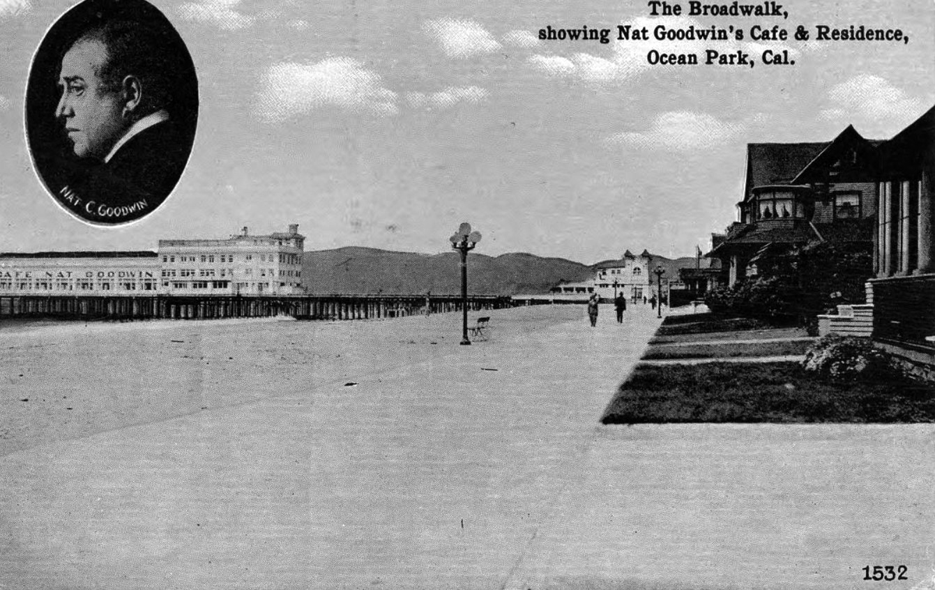
Café Nat Goodwin
 |
|
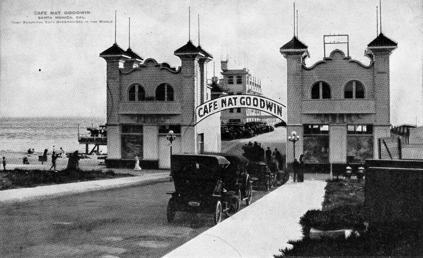
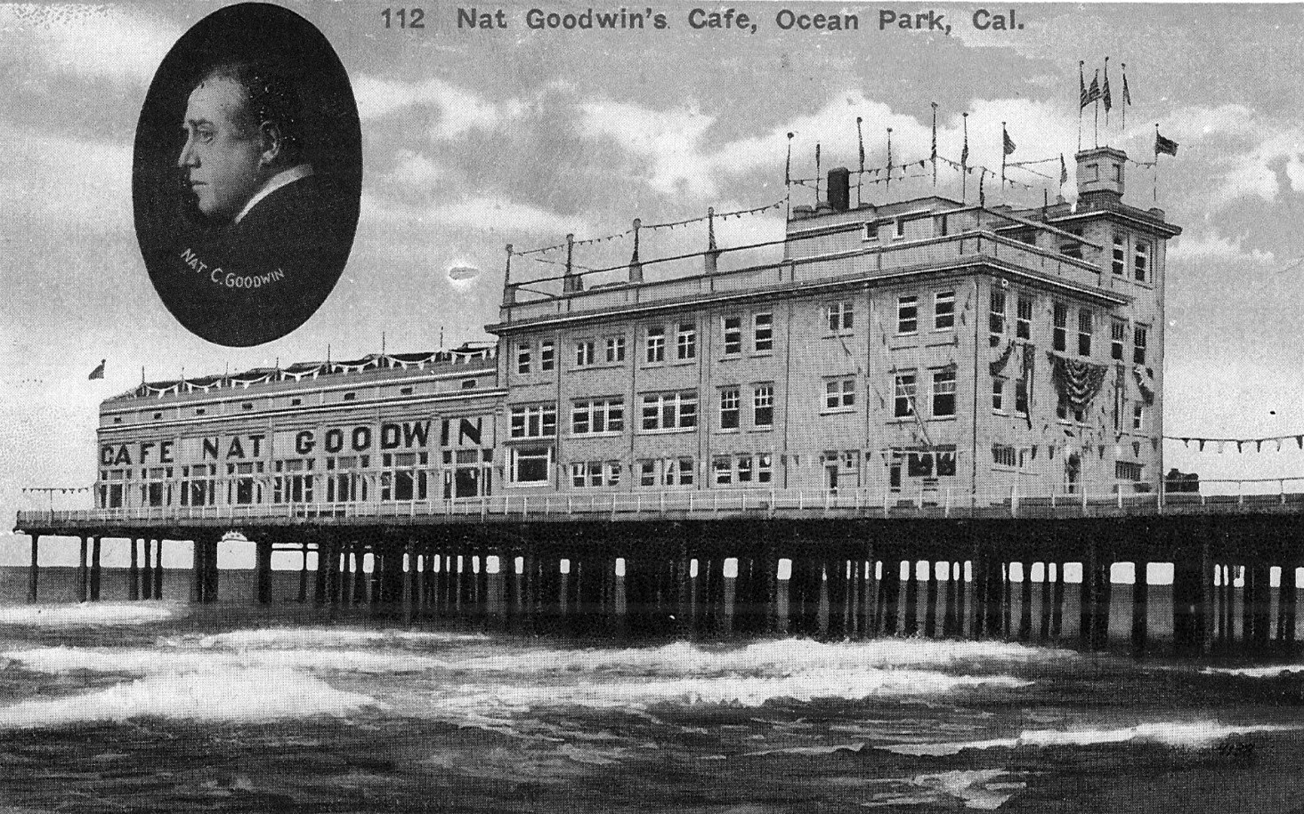
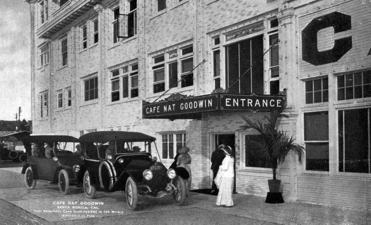
| (1917)* – View showing cars parked at the foot of Hollister Avenue in front of the private Bristol Pier. A large arched sign reads Café Nat Goodwin. Courtesy of Ernest Marquez Collection |
Historical Notes Nat Goodwin was a vaudevillian comic who also appeared in a few films between 1912 and 1916. In about 1913 Goodwin opened a club on the private Bristol Pier in Santa Monica. The Cafe Nat Goodwin was one of the swankiest on the beach and included a cabaret, ballroom and a roof garden. Goodwin's club was frequented by fellow film funny folks, Charlie Chaplin, Mabel Normand, and Mack Sennett and soon became an area hot spot. Goodwin sold his cafe to Baron Long about 1919 and it became the Sunset Inn. Goodwin died in 1919. |
 |
|
| (ca. 1917)* – Postcard view of Café Nat Goodwin located on the private Bristol Pier in Santa Monica. |
Historical Notes The restaurant, Cafe Nat Goodwin, was located on Hollister Avenue at Crystal Pier in Ocean Park. It claimed to be the "largest and best cafe on the Pacific coast." Originally, the Crystal Pier was named the White Star Pier, then was renamed the Bristol Pier after the Bristol Cafe located there. When Nat Goodwin took over the Bristol Cafe and renamed it the Cafe Nat Goodwin, the Pier became known as the Crystal Pier. |
 |
|
| (1917)* - Postcard photo showing entrance to Café Nat Goodwin located on Bristol Pier, Santa Monica. |
Historical Notes Goodwin opened an incredibly hip and exclusive operation that took use of a ball room, inclusive gardens on the roof and live cabaret. This era in the early 20th century was full of expansion and Goodwin recognized that, renaming the pier — Crystal Pier. Shortly after renaming the restaurant, Goodwin sold the restaurant to Baron Long. The Nat Goodwin Cafe on Ocean Park became the Sunset Inn and Goodwin died later that year from “shock” two weeks after his eye was removed. At the time of his death, Goodwin was deeply in debt, with his estate listing assets of $6,895 and debts of $15,000. When he died he was said to have been engaged to the actress Georgia Gardner. White Star Pier (1905 - 1908) – Bristol Pier (1908 - 1919) – Crystal Pier (1919 – 1949) |
 |
|
| (1913)* - Santa Monica High School Junior Prom at the ballroom of the Café Nat Goodwin on Bristol Pier, April 18, 1913. |
Historical Notes lThe ballroom at Café Nat Goodwin, part of the upscale dining complex on Bristol Pier, was a key feature of the establishment when it opened in 1913. Reflecting the café's status as a fashionable entertainment destination, the ballroom was elegantly decorated and spacious enough to accommodate live music and dancing, complete with a proper dance floor for popular dances of the era. This multi-faceted venue, which also included a cabaret and roof garden, catered to wealthy patrons and celebrities, enhancing its reputation as one of the "swankiest" spots on the beach. |
 |
|
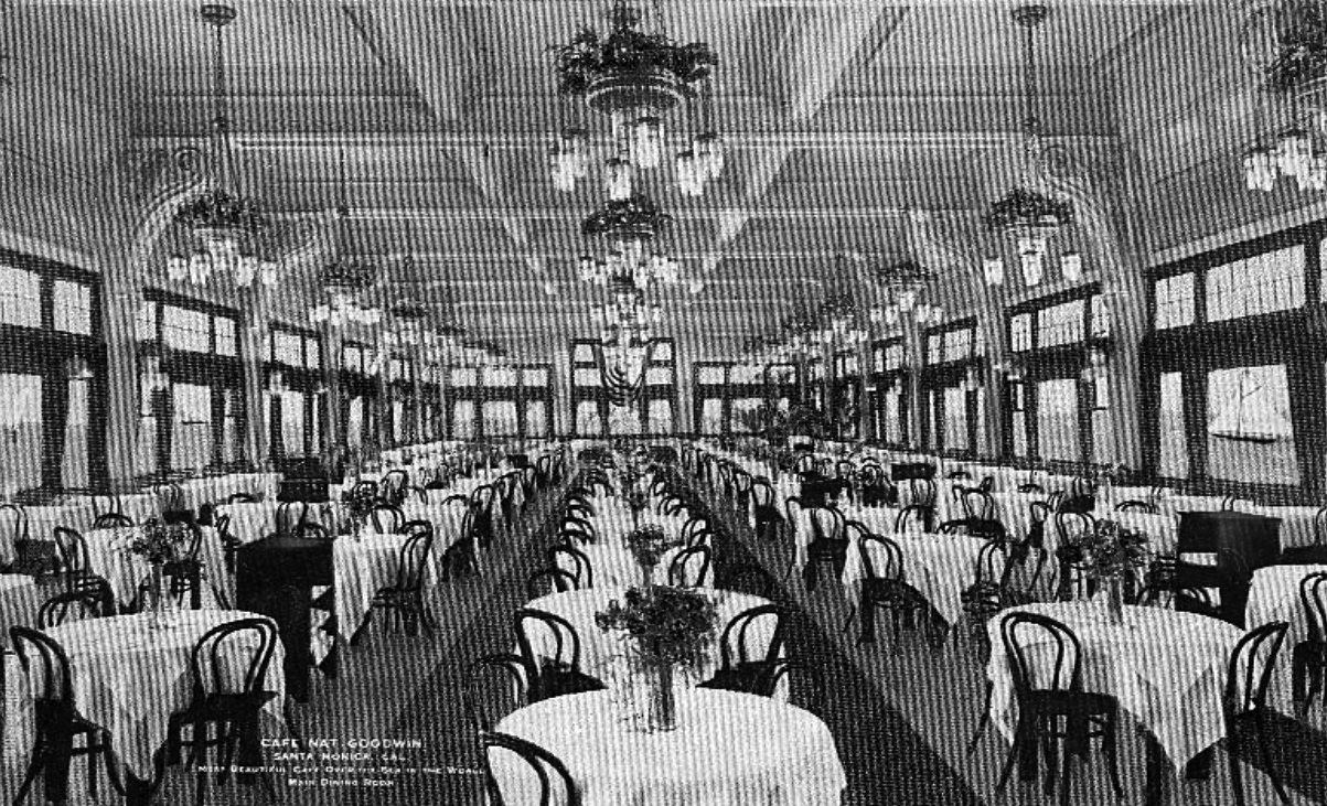
| (ca. 1917)* – Postcard photo showing main dining room at the Café Nat Goodwin. |
 |
|
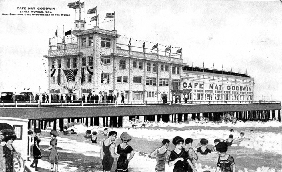
| (ca. 1917)* - Postcard view showing the grand restaurant built by Nat Goodwin on a pier that hangs above the ocean. |
 |
|
| (ca. 1915)* – Postcard view looking north showing the boardwalk leading to Bristol Pier where the where Nat Goodwin's Cafe is located with residences seen on the right. |
Historical Notes After Nat Goodwin sold the business, its name was changed to the Sunset Inn. |
 |
|
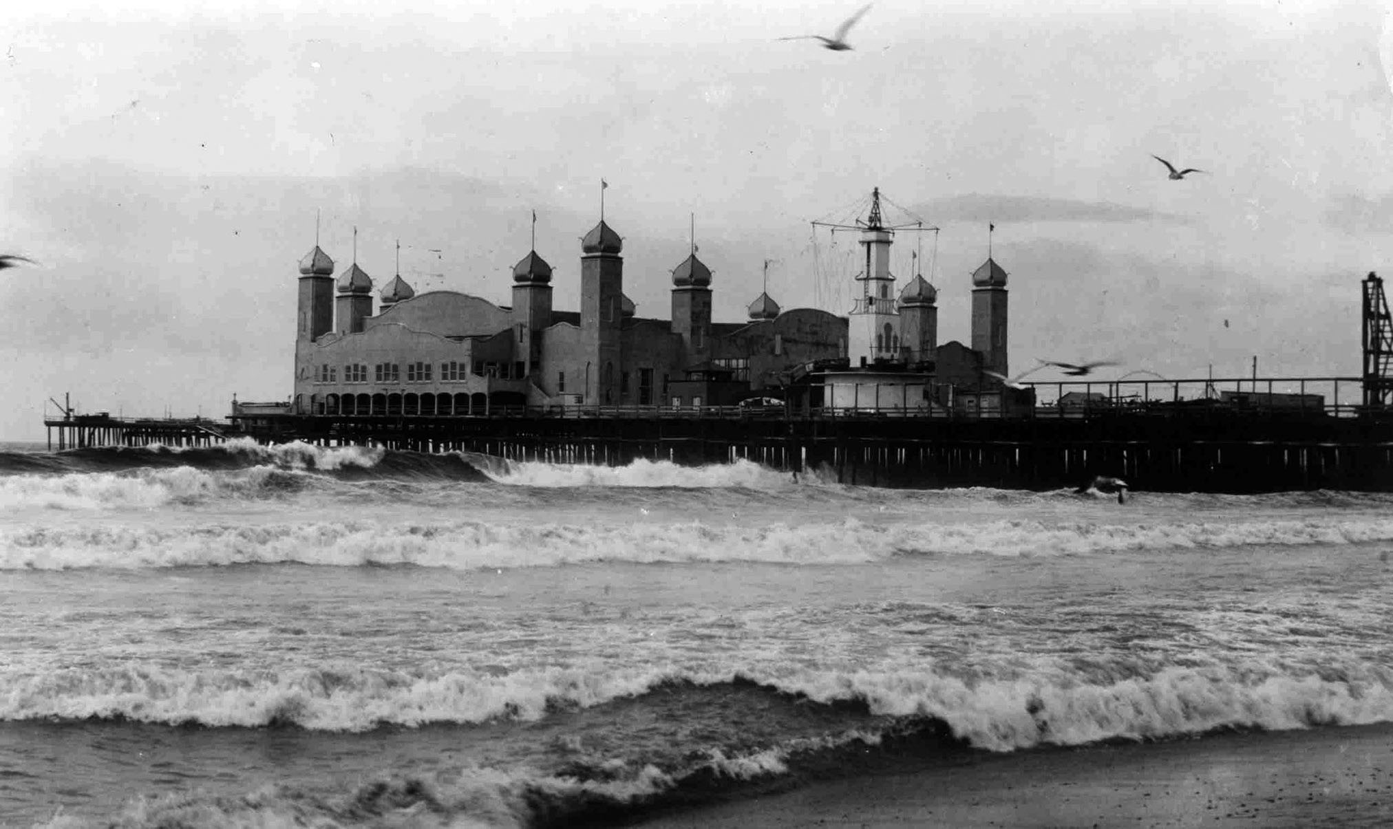
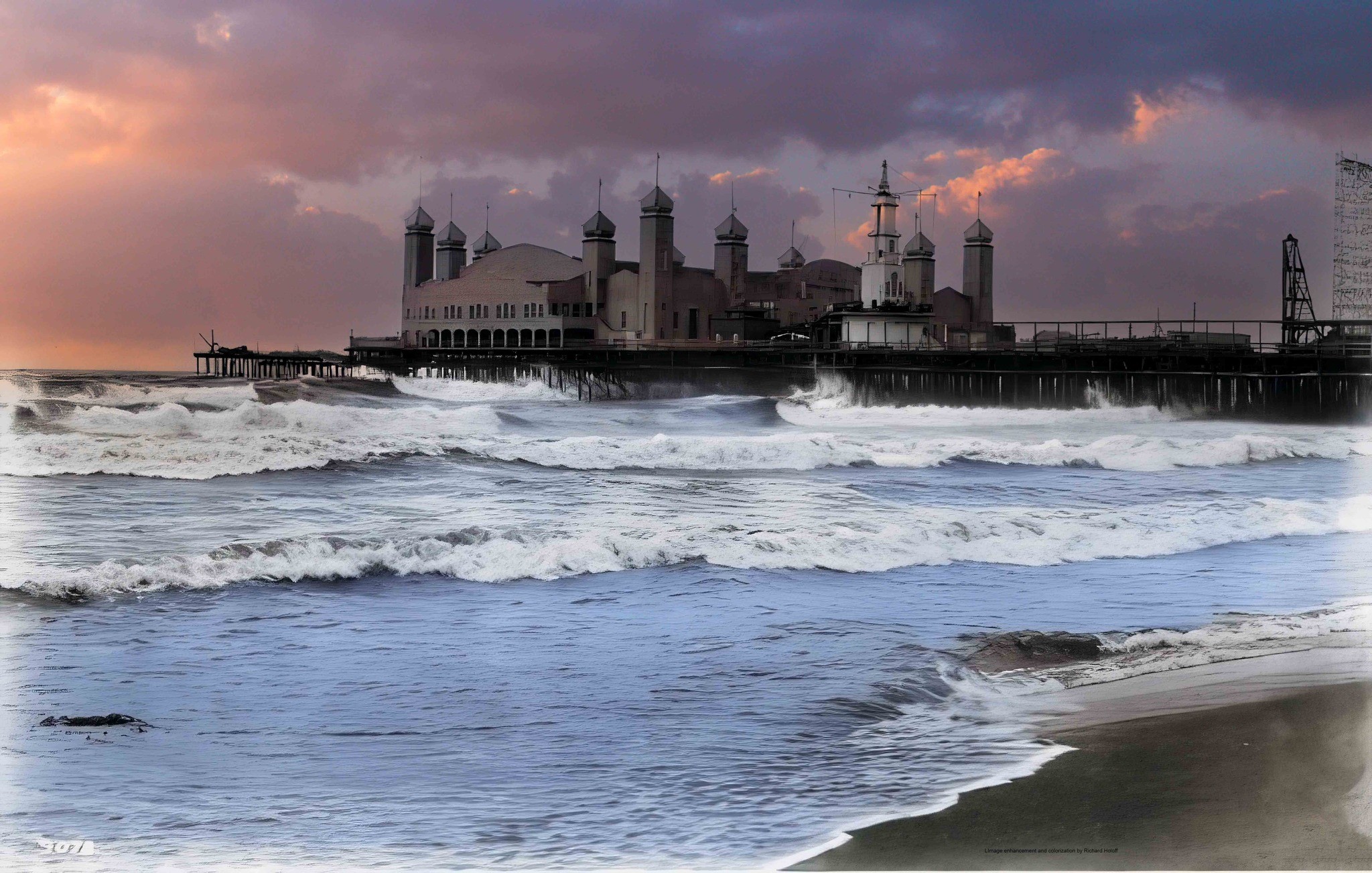
| (1923)* – Aerial view looking at the Crystal Pier showing the Rendevous Ballroom. Note how much shorter the pier is when compared to earlier photos (most likely due to storm damage). |
Historical Notes Records show the pier had three names during its existence, from its construction in 1905 to its demolition in 1949: White Star Pier (1905–1908) Bristol Pier (1908–1919) Crystal Pier (1919–1949) |
* * * * * |
Santa Monica's Cement Boardwalk and Piers
 |
|
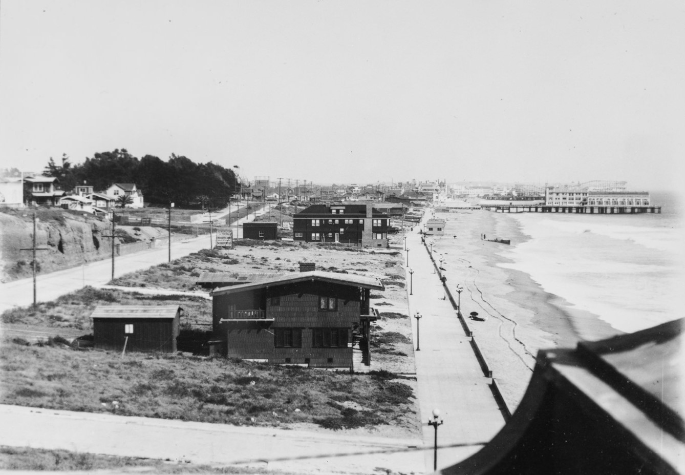
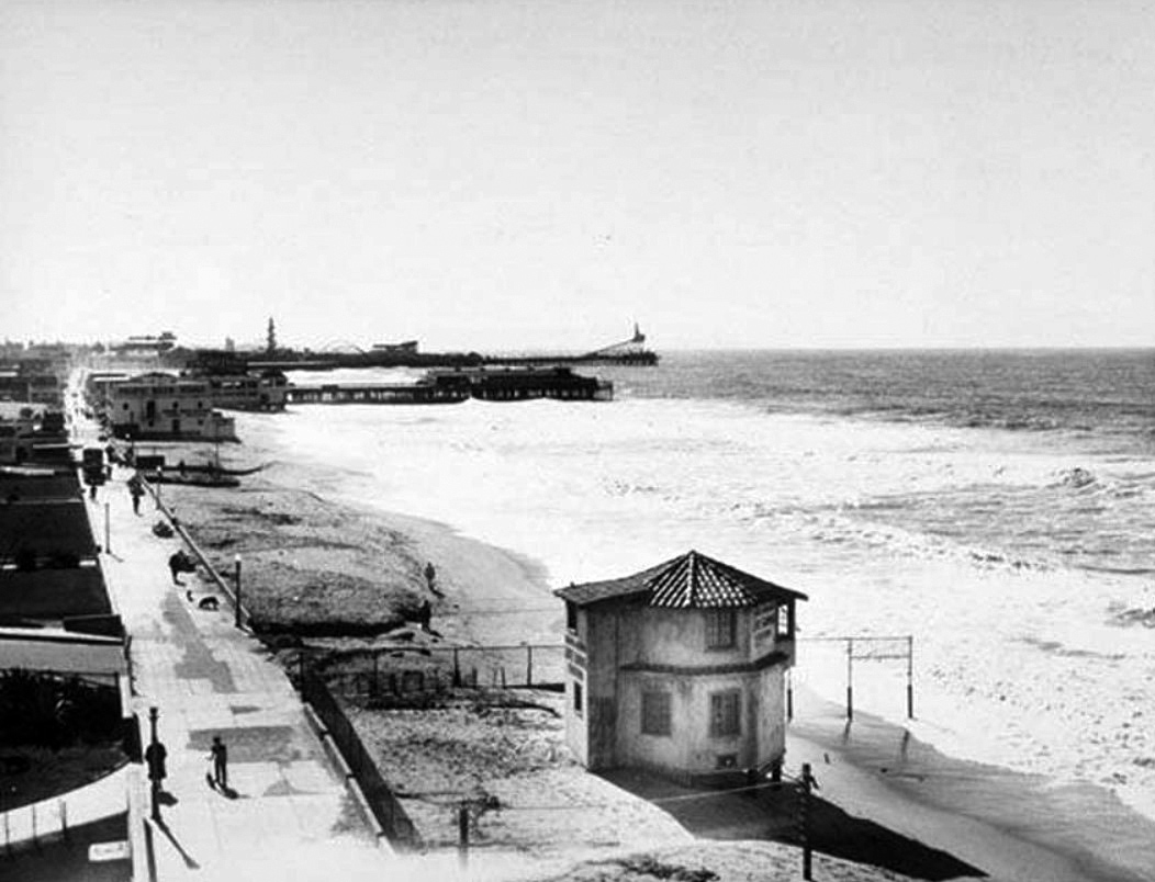
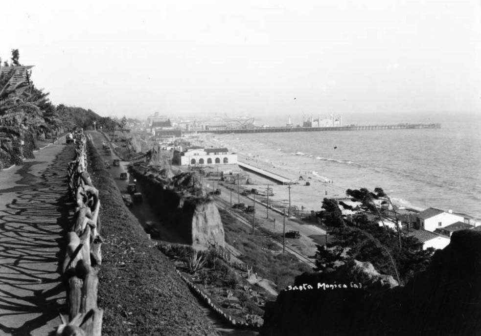
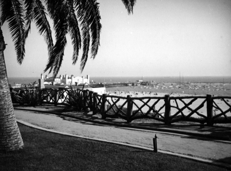
| (ca. 1915)* - Birdseye view of the beach in Santa Monica looking south with Bristrol Pier in the background. The beach is a wide, sandy tract of land that extends from the foreground away from the viewer into the distance at center. There are a few people playing in the surf and many people resting beneath umbrellas or tents on the sand. The left side of the beach is bordered by a cement sidewalk, and a large number of pedestrians is walking along the path. At left, a series of two-story beach houses lines the sidewalk. Several early-model automobiles are parked in driveways and alleys near the sidewalk at left. There is a short pier jutting out into the water in the background at center and a large building is constructed near the right side of the pier. |
Historical Notes In the early 1900s, Santa Monica's boardwalk emerged as a vibrant coastal destination that captured the imagination of Southern California's growing population. Anchored by the newly constructed Santa Monica Pier, which opened in 1909, the area became a bustling hub of entertainment and leisure. The Pacific Electric Railroad made the beach easily accessible, drawing visitors from across Los Angeles who came to enjoy roller coasters, carousels, vaudeville shows, and seaside attractions. |
 |
|
| (ca. 1915)* - Photograph of people on the beach in Santa Monica, looking south toward Bristol Pier. Four people in bathing suits stand in the sand of the beach on the right with the water washing in and out behind them. A tile sidewalk lies on the left where people stay finely dressed in their automobile. A shop can be seen on the far left of the sidewalk further back while a large building stands on the beach in the background. |
Historical Notes The boardwalk was more than just an amusement area; it was a social center where people could swim, sunbathe, and gather at venues like the Casino Restaurant and Japanese Tea Garden. Wealthy elites and working-class families alike were drawn to the pier's attractions, while surrounding commercial developments sprouted banks, restaurants, and furnished rooms to support the growing tourism industry. |
 |
|
| (1910s)* – Looking south from near the Santa Monica Pier, the view shows beach houses lining the boardwalk. In the distance, Bristol Pier (renamed Crystal Pier in 1919), home to the once-famous Café Nat Goodwin, is visible, with Ocean Park Pier and its roller coasters further back. On the left, a sign along the road reads "Kensington Terrace, Residents Only ...". Photo from the Ernest Marquz Collection. |
Historical Notes Café Nat Goodwin openend in 1913. Goodwin sold his cafe to Baron Long about 1919 and it became the Sunset Inn. The name of the pier also changed in 1919 from Bristol Pier to Crystal Pier. Kensington Terrace was a distinctive residential development in Santa Monica during the 1920s, created by developer Elliot Schrader between the Vicente Terrace and Seaside Terrace tracts. Situated along the city's rapidly developing coastline, the tract emerged during a transformative period when Santa Monica was experiencing significant urban growth, with its population nearly doubling from 15,000 to 32,000 during the decade. Like many coastal developments of its era, Kensington Terrace likely represented an upscale residential area targeting affluent homeowners seeking proximity to the beach and the city's emerging urban amenities. While specific architectural and demographic details remain limited, the tract was part of the broader real estate expansion that characterized Santa Monica's coastal landscape in the early 20th century, reflecting the city's economic prosperity and growing desirability as a residential destination during the Roaring Twenties. |
 |
|
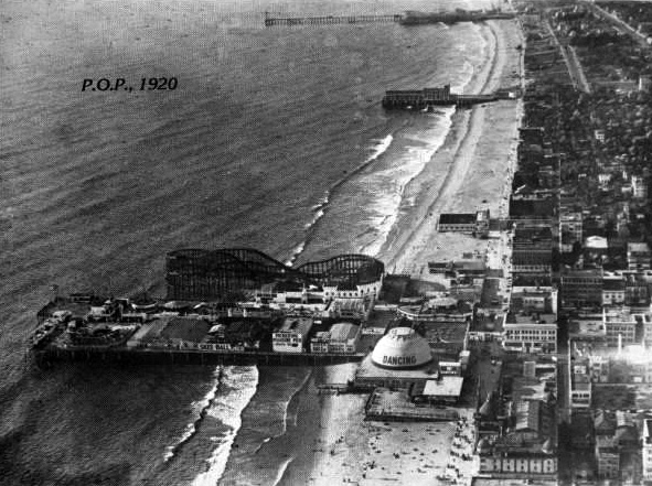
| (1920)* - Aerial view of Ocean Park Pier showing it's large roller coster. The long pier to the north (top of photo) is the Santa Monica Pier. It too had its own amusement park starting in 1916. In between the two longer piers is the shorter Crystal Pier (originally White Star Pier then Bristol Pier). |
Historical Notes In the 1920s, Santa Monica Bay was lined with numerous piers due to the area's booming tourism, vibrant recreational activities, and strategic importance for transportation and commerce. The piers served as hubs for economic growth, attracting visitors with entertainment, dining, and amusement parks. Additionally, they enhanced real estate development by making coastal properties more attractive and served as key social and community gathering spots. |
 |
|
| (1928)* – A strongman in a leopard-print bodysuit pulls a car packed with beachgoers by his teeth, near one of Santa Monica’s piers. Just another day of seaside spectacle and vintage showmanship. Photo from the Ernest Marquez Collection. |
Historical Notes In the 1920s, Santa Monica’s piers were vibrant hubs of entertainment where seaside spectacles and vintage showmanship were common. Acts like a strongman in a leopard-print bodysuit pulling a car full of beachgoers by his teeth fit perfectly into the lively beach culture of the time. The piers featured a mix of vaudeville performances, athletic feats, and circus-like stunts designed to captivate crowds. This tradition of public displays of strength and novelty acts helped define Santa Monica as a popular playground blending physical culture, spectacle, and Hollywood glamour well before the famous Muscle Beach era of the 1930s |
 |
|
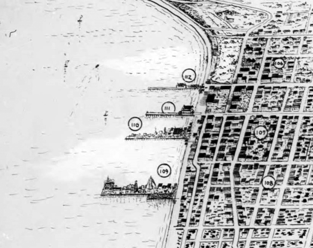
| (1927)* – Detail of a map showing four of the main piers in Santa Monica Bay. |
Historical Notes 112 – Santa Monica Pier 111 – Crystal Pier 110 – Ocean Park Pier 109 – Pickering Pier / Venice Pier Click HERE to see more of the Piers of Santa Monica Bay. |
 |
|
| (1938)* - View looking south toward Crystal Pier with the longer Ocean Park Pier and amusement park seen in the distance. |
Historical Notes Click HERE to see more of the Piers of Santa Monica Bay. |
* * * * * |
 |
|
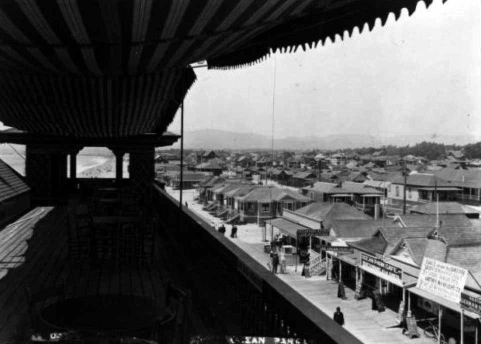
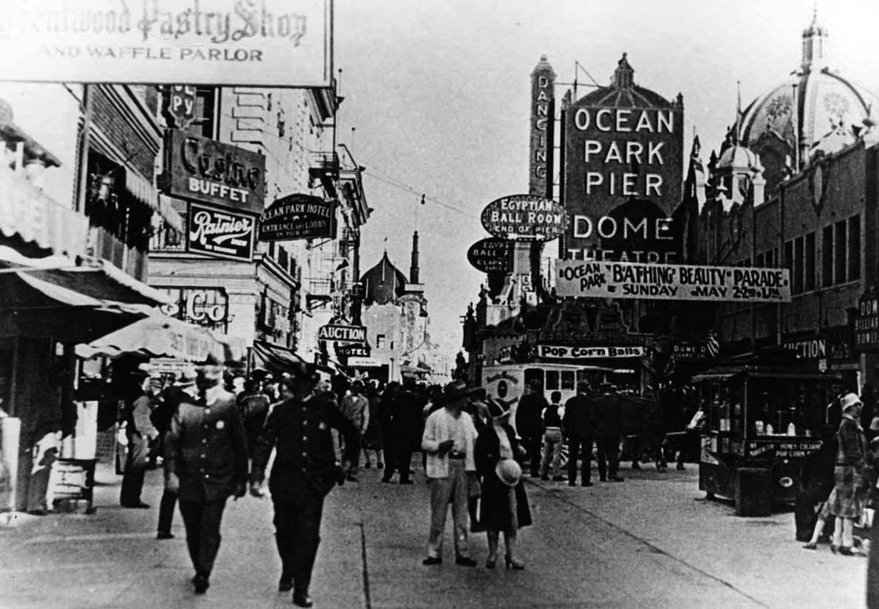
| (ca. 1915)* - View from the second story of a pavilion on the Ocean Park pier, showing shops and beach houses. A portion of roof covered by a cloth canopy is pictured in the left foreground, four sets of tables and chairs spaced regularly under the shade. Over its edge to the right, a collection of small shop fronts can be seen advertising their wares via signs, while farther in the distance at center, an expanse of housing can be seen stretching toward the mountains.; Legible signs from left to right include: "These chairs for patrons only", "Clairvoyant", "Lunch Room", "Ocean Park Review Job Printing", "Cigars and Tobacco", "Ice Cream Parlor", "99 Ocean Park Cafe. Restaurant A la Carte". |
 |
|
| (1915)** - Exterior view of the Las Flores Inn on the coast road near Santa Monica. The inn is at right and has a steeply peaked roof with its name painted near the top. Part of the inn extends back to the ocean behind it. A wooden structure is seen covering tables at left, and there is a fenced-in garden at left. Several cars are parked in front of the inn and the garden, and there are people standing in front of the inn. A horse is tied near the ocean at left. |
Historical Notes Las Flores Inn was located near where Duke’s Restaurant is today, by Las Flores Canyon. The coast route ended at Las Flores Canyon until the late 1920s, when the Roosevelt Highway was completed. Children used to wait here for the school bus to Santa Monica. Their parents played the slot machines at the restaurant and a big win meant soda pops for all. It is said the inn refused to pay "protection fees" and lost their slots, but the Malibu Inn up the road kept theirs.^## |
 |
|
| (1916)#^ - View of the Golden Butterfly establishment in Santa Monica Canyon, below Adelaide Drive. |
 |
|
| (1916)#^ - View showing people enjoying the Fourth of July on the beach at the entrance to the Santa Monica Canyon. A large bathouse and two piers are seen in the background. |
 |
|
| (1916)#^ – View of the beach at the entrance to Santa Monica Canyon. The Santa Monica bathouse is seen in the background. |
 |
|
| (1916)#^ - View of the road to Topanga Canyon as seen from the Santa Monica Bath House. The Long Wharf can be seen in the distance. The beach is full of people between the bath house and the pier. The right side of the sign in the foreground reads: "Where Ocean and Mountains Meet" |
 |
|
| (1916)#**- View of streetcar 149 leaving Santa Monica en route to the Long Wharf. |
Historical Notes The above streetcar was built by American Car Co. in 1902 for the San Bernardino Valley Traction Co. and later purchased by the Pacific Electric Railway Company. The car was eventually scrapped in 1926. #** The last ships arrived at the Long Wharf in 1908, however, the wharf lived on as a tourist destination, accessed by a trolley from Santa Monica. The wharf was demolished in stages, and disappeared entirely by 1920.#^^^ |
 |
|
| (ca. 1920)#^# - Relief map of territory served by lines of the Pacific Electric Railway in Southern California. At the time of the photo it was the largest electric railway system in the world. Note the line heading to the Port of Los Angeles (The Long Wharf). |
 |
|
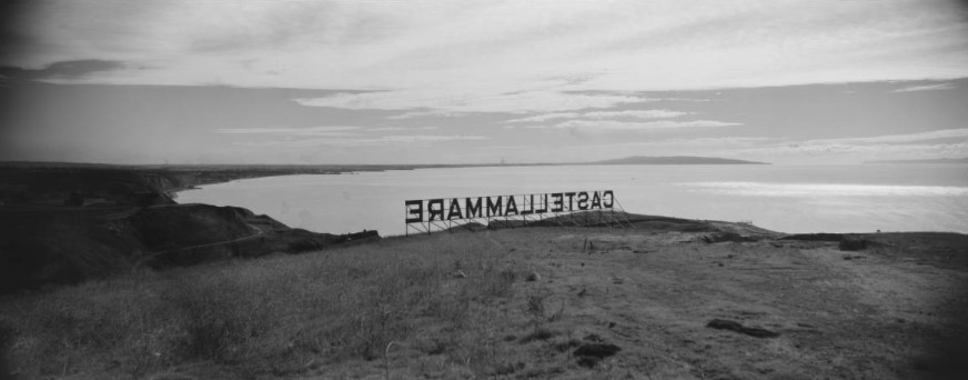
| (1926)#^^ - A panorama view of the California coastline at the Castellammare development area in Pacific Palisades in Los Angeles. The land is still undeveloped, with only a sign spelling out the development name perched on a hill. The land was under development by Frank Meline. |
Historical Notes Castellammare (Castle by the sea) is located along the Pacific Coast Highway on small bluffs much closer to sea-level, just north of where Sunset Boulevard meets the PCH. This is the home of the Getty Villa and the narrow, winding streets in this neighborhood have Italian names and ocean breezes.*^ |
Bel-Air Bay Club
 |
|
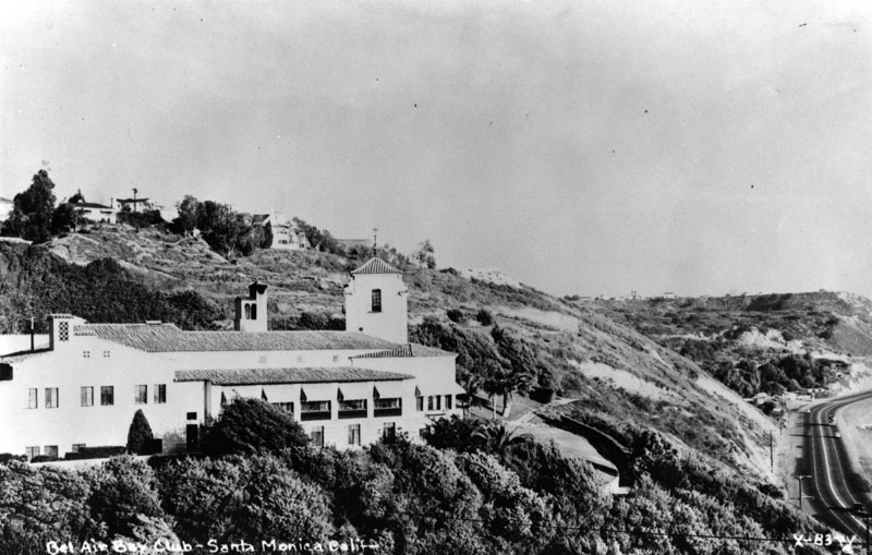
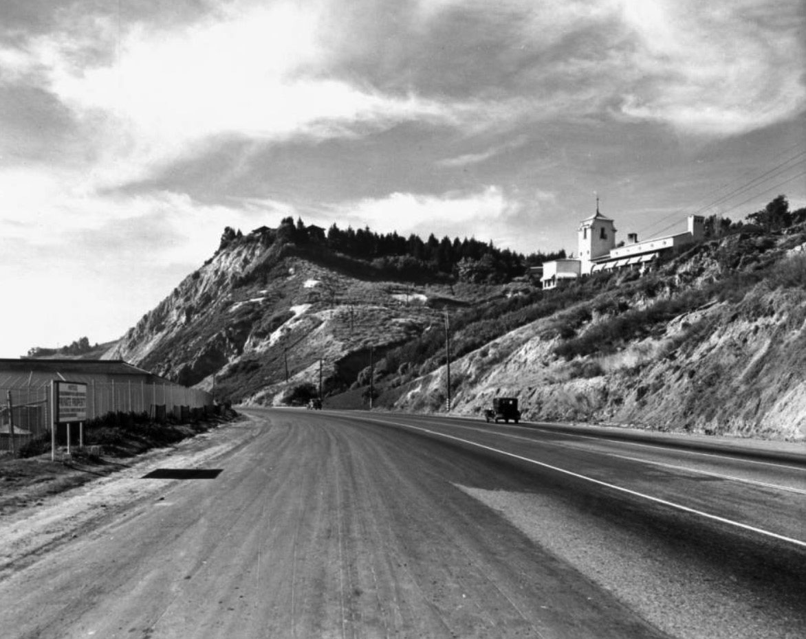
| (ca. 1927)* - The Bel-Air Bay Club in Pacific Palisades, although “Santa Monica” is present on the print. To the right can be seen a portion of the Roosevelt Highway (Pacific Coast Highway). |
Historical Notes In 1927, Alphonzo Bell built the Spanish Colonial Revival style Bel Air Bay Club located at 16801 Pacific Coast Highway, Pacific Palisades. The club is still standing today, although modified.* Alphonzo Bell was an American oil multi-millionaire, real estate developer, philanthropist, and champion tennis player. The westside Los Angeles residential community of Bel-Air is named after him. Bell was a native and lifelong resident of Los Angeles whose family had deep financial and historical ties to the area, and played a key role in the history and development of Southern California. He was the son of James George Bell, who established Bell Station Ranch (now the site of the City of Bell), in the Santa Fe Springs area in 1875, and of Susan Albiah Hollenbeck. His uncle, Ed Hollenbeck, who arrived in California in the 1850s, founded the First National Bank, created Los Angeles's public transportation trolley system, and developed eastern portions of Los Angeles County.*^ |
 |
|
| (1927)#^^ – People overlooking the Santa Monica Bay and beach from the site of the upper clubhouse of the Bel-Air Bay Club site, with the lower clubhouse building under construction in the foreground on the beach in Pacific Palisades. Automobiles can be seen along the Beach Road (later the Roosevelt Highway and Pacific Coast Highway), and Santa Monica and the Santa Monica Pier are visible in the distance. |
 |
|
| (1930s)** – View looking north on Pacific Coast Highway showing the two facilities of the Bel-Air Bay Club. One facility is on the left along the beach and the other is the Spanish Colonial Revival-style building on the hillside at upper-right. Also seen in the distance, on top of the hill, is the famed Bernheimer Japanese Gardens. |
Historical Notes Bel-Air Bay Club consists of two facilities separated by the Pacific Coast Highway. The grounds are located on one-quarter mile of beachfront, with a total of 14 acres including picturesque bluffs overlooking the sea. |
 |
|
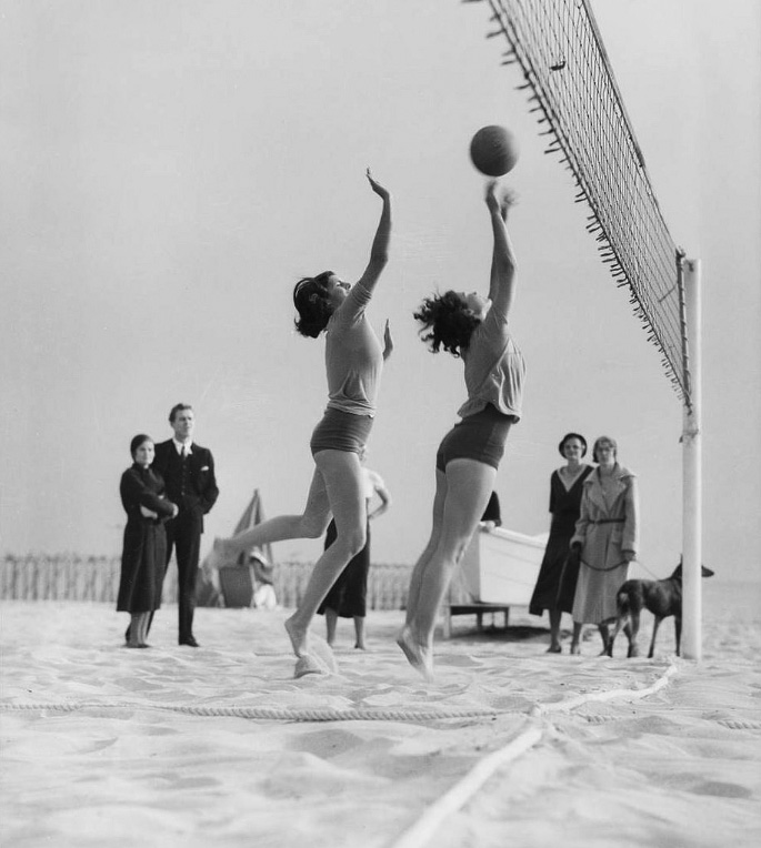
| (1931)* – View showing beach volleyball in front of the Bel-Air Bay Club. |
Historical Notes The Club was such a center of social activity during the 1920s, 1930s and 1940s that many celebrities frequented Club functions. |
* * * * * |
 |
|
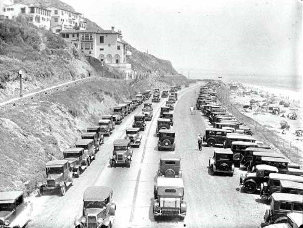
| (1920s)* – View looking south on Roosevelt Highway (later PCH) showing a busy day at the beach with parking spaces hard to come by. |
* * * * * |
Toed Inn
 |
|
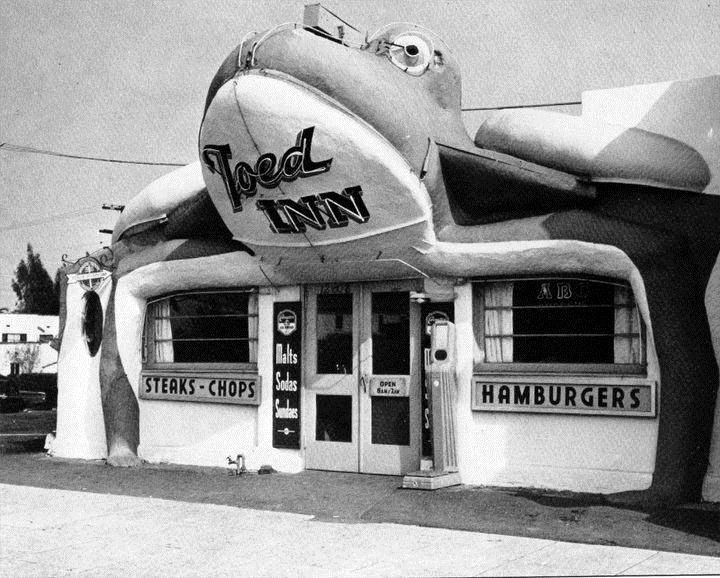
| (1929)* - The Toed Inn, was a stand in the shape of a toad, located on Channel Road in Santa Monica. Behind can be seen the Seaside Service Station. |
Historical Notes Opened in 1929 at 124 West Channel Road in Santa Monica Canyon, the original Toed Inn was a charming example of programmatic architecture—designed in the shape of a giant frog, with customers entering through its open mouth. Owned by Roger C. McGinn and designed by architect Jacob Lee Schimmer, the whimsical structure quickly became a roadside attraction for beachgoers and motorists alike. In 1931, the building was moved to a larger adjacent lot and expanded, but it met disaster in 1938 when a catastrophic flood damaged and partially buried the restaurant in mud, forcing it to close. |
 |
|
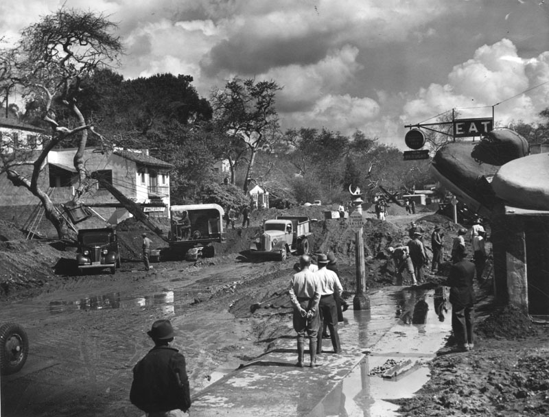
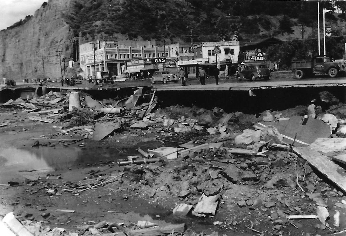
| (1938)* - Photo shows the cleanup of Channel Road in Santa Monica Canyon. Tons of mud and silt were deposited from the flood waters which raced down the canyon. The Toed Inn is on the right. |
Historical Notes In 1938, the Toed Inn structure was damaged by a flood caused by one of wettest seasons ever to hit Southern California. That same year the Toed Inn was relocated to West Los Angeles, at 12008 Wilshire Boulevard. |
 |
|
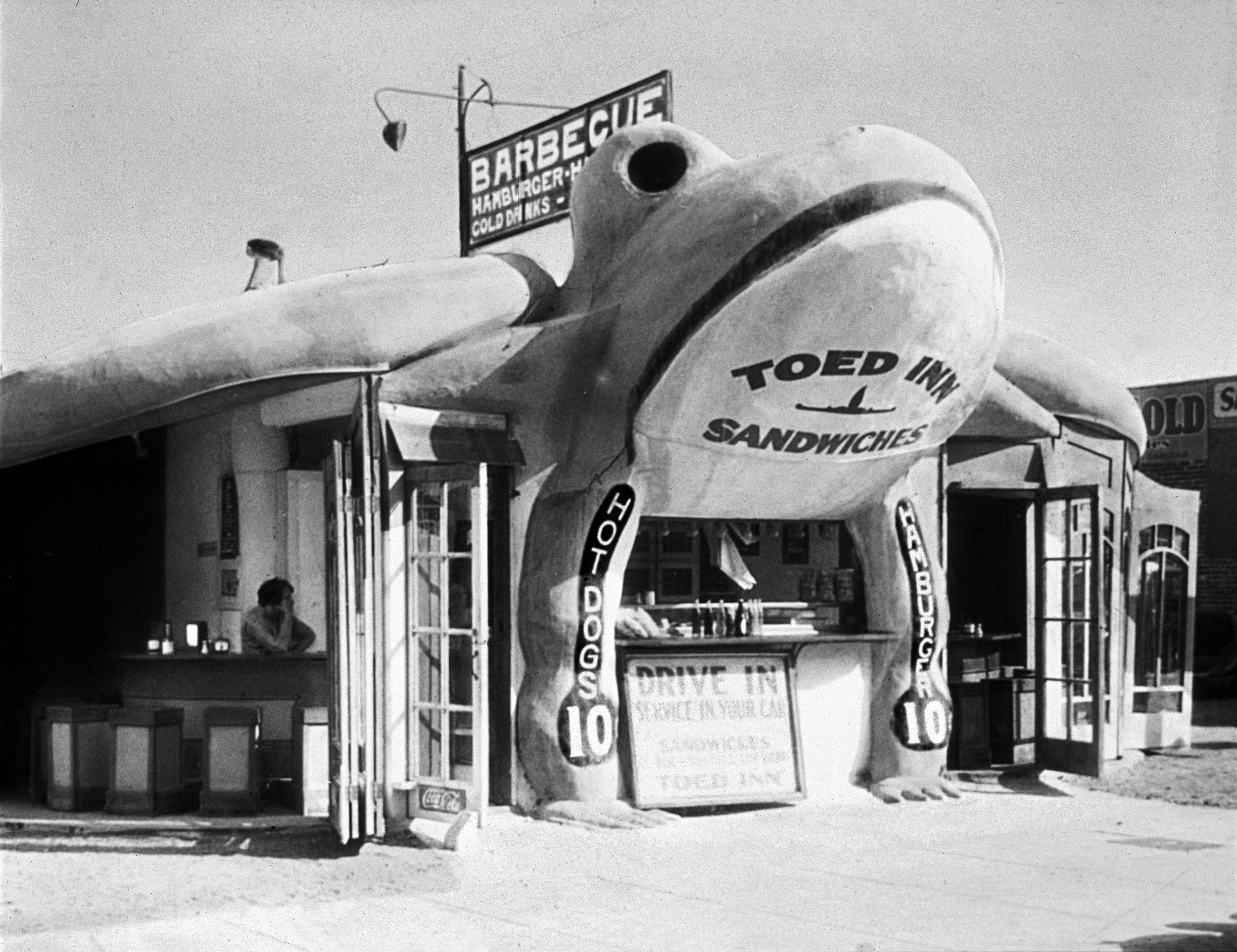
| (ca. 1939)* - The Toad Inn at it's new location at 12008 Wilshire Boulevard in West Los Angeles.. |
Historical Notes In early 1939, McGinn relocated the damaged frog structure several miles inland to 12008 Wilshire Boulevard, near Saltair Avenue in West Los Angeles. The front was rebuilt using accordion-style doors, and the restaurant reopened in a more enclosed and modernized form while still retaining its signature amphibian charm. The move positioned the Toed Inn along a major urban corridor, where it continued to draw attention with its fanciful design and playful theme. It was eventually sold to Benjamin Rosenfeld, who made further enhancements including neon signage and a new front façade. |
 |
|
| (1940)* - Toed Inn located at 12008 Wilshire Boulevard after it became a drive-in restaurant. Click HERE to see more Early LA Drive-in restaurants. Photo from the Jim Heimann Collection. |
Historical Notes During the 1940s, the Toed Inn thrived as a drive-in restaurant, fitting perfectly into the car-centric culture of postwar Los Angeles. Known for hearty meals—steaks, barbecue, fried chicken, and even frog legs—it became a local favorite and was featured in publications like the Saturday Evening Post. However, by the early 1950s, novelty architecture began to fall out of favor, and the restaurant closed in 1953. The building was replaced with a more conventional establishment called Ben’s, but the giant frog lives on in L.A. lore as one of the city’s most endearing roadside oddities. Click HERE to see more examples of Programmatic Architecture. |
* * * * * |
Flooding (1938 Storm)
 |
|
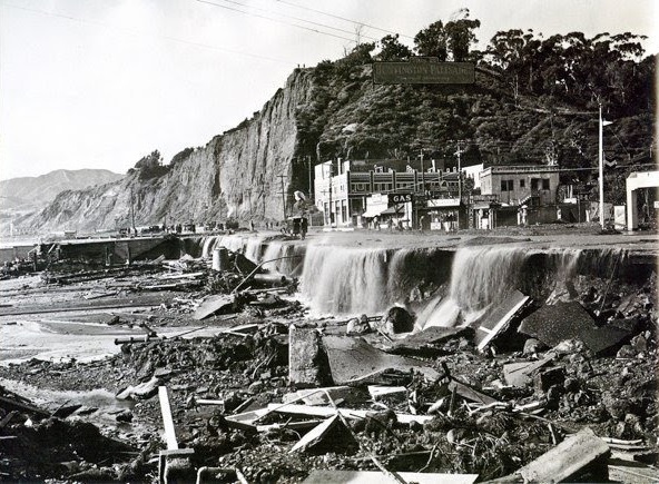
| (1938)^ - View showing the Santa Monica Canyon flood of 1938. The sign on top of the hill reads: HUNTINGTON PALISADES. |
Historical Notes Between February 27 and 28, 1938, a storm from the Pacific Ocean moved inland into the Los Angeles Basin, running eastward into the San Gabriel Mountains. The area received almost constant rain totaling 4.4 in from February 27-March 1. This caused minor flooding that affected only a few buildings in isolated canyons and some low-lying areas along rivers. Fifteen hours later on March 1, at approximately 8:45 PM, a second storm hit the area, creating gale-force winds along the coast and pouring down even more rain. The storm brought rainfall totals to 10 inches in the lowlands and upwards of 32 inches in the mountains. When the storm ended on March 3, the resulting damage was horrific. |
 |
|
| (1938) – Aftermath of the Santa Monica Canyon flood. Photo courtesy of Sarah Marinelli |
.jpg) |
|
| (1938) – Santa Monica Canyon flood aftermath. Photo courtesy of Sarah Marinelli |
.jpg) |
|
| (1938) – Channel Road in Santa Monica Canyon after the great flood. Photo courtesy of Sarah Marinelli |
|
|
| (1938)* - Photo shows the cleanup of Channel Road in Santa Monica Canyon. Tons of mud and silt were deposited from the flood waters which raced down the canyon. The Toed Inn is seen on the right. |
Historical Notes After the 1938 Santa Monica Canyon flood, the Toed Inn was relocated to Westwood, at 12008 Wilshire Boulevard. |
* * * * * |
Pacific Palisades
 |
|
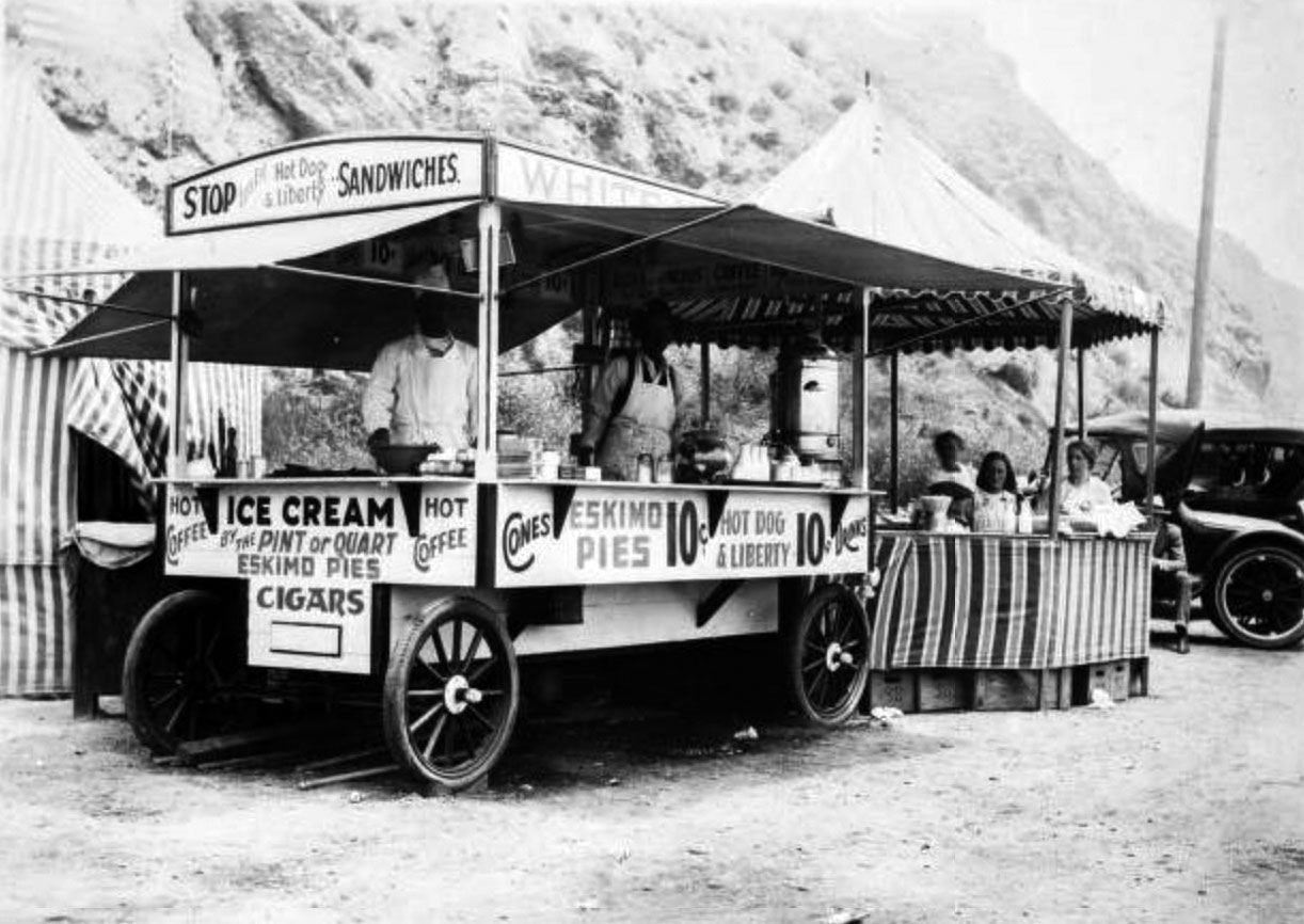
| (ca. 1918)* - Image of a food stand on the beach, with vendors behind counter in Pacific Palisades. The cart may say "White House" above the awning (the sign is partially obscured). The cart has signs including "Stop, Let's Eat Hot Dog & Liberty Sandwiches" and "Hot coffee, Ice Cream by the pint or quart, Eskimo Pies, Cigars, Cones... Drinks." |
 |
|
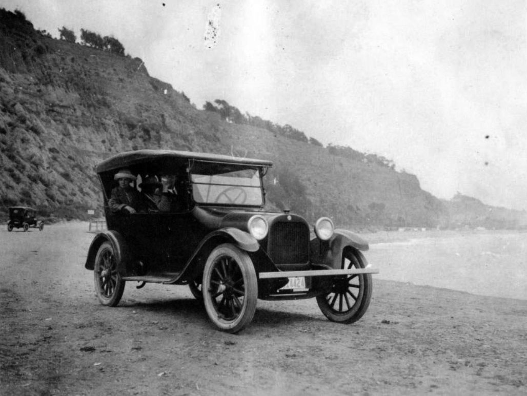
| (1922)* - A 1918 Dodge Brothers touring car on the beach just south of the Long Wharf location in Pacific Palisades. |
* * * * * |
Santa Monica Palisades
 |
|
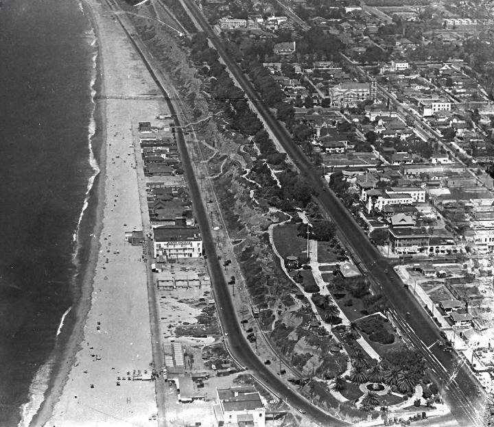
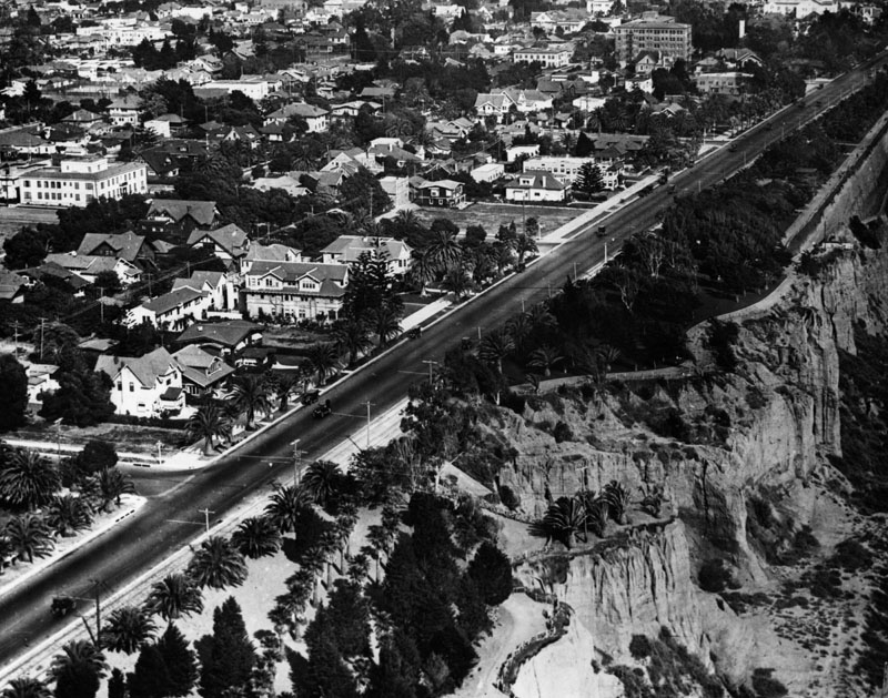
| (1922)*– Aerial view looking north from above the Santa Monica Pier, showing the Pacific coastline with beach houses lining the shore, the Roosevelt Highway (now Pacific Coast Highway), and the terraced bluffs of Palisades Park. Ocean Avenue runs parallel to the bluffs, bordered by early residential neighborhoods and palm-lined streets. Several civic and institutional buildings can be seen near Arizona Avenue. This image captures Santa Monica’s coastal development during the early automobile era. |
Historical Notes Roosevelt Highway, visible hugging the coastline, was part of a larger coastal route proposed in the 1910s and officially named in 1921 to honor President Theodore Roosevelt. It was later incorporated into Pacific Coast Highway (PCH) in the 1930s.
|
 |
|
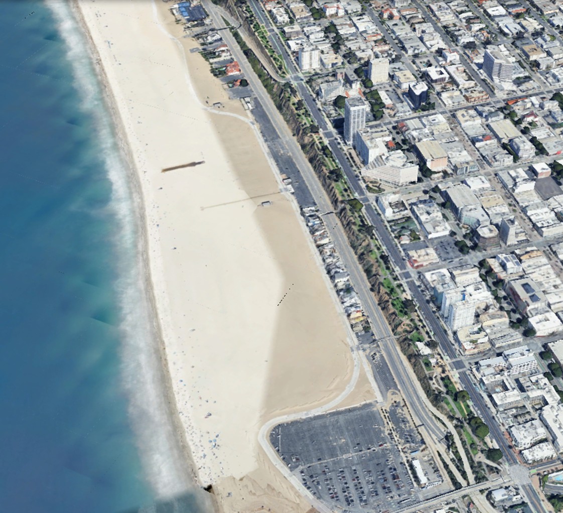
| (2022)* - Contemporary View – A Century of Change Along Santa Monica’s Coastline |
Historical Notes This modern Google Earth view, looking north from above the Santa Monica Pier area, reveals the dramatic transformation of the coastal landscape since 1922. The once dense row of beach houses seen in the earlier aerial has been replaced by wide, open sand and uninterrupted public beach access. Roosevelt Highway is now Pacific Coast Highway (PCH)—modernized and expanded to accommodate heavy traffic. Ocean Avenue still runs parallel to the bluffs, though it is now lined with mid- and high-rise buildings, reflecting Santa Monica’s evolution into a vibrant urban center. The terraced bluffs and pathways of Palisades Park remain a constant, offering a preserved stretch of green between city and sea. Note on the Widened Beach: |
.jpg) |
|
| (1922)* - Aerial view of the Palisades and various residential homes in Santa Monica. Ocean Avenue and Palisades Park runs parallel to the cliffs. Roosevelt Highway and Santa Monica beach can be seen below the cliffs. |
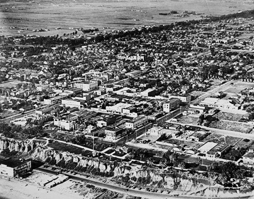
Historical Notes The nationwide prosperity of the 1920s was felt in Santa Monica. The population increased from 15,000 to 32,000 at the end of the decade. Downtown saw a construction boom with many important buildings going up such as Henshey's Department Store (destroyed) and the Criterion Theater. Elegant resorts were opened, including the 1925 Miramar Hotel and the 1926 Club Casa del Mar. The Los Angeles firm of Walker & Eisen designed the art deco Bay City Building, a 13-story skyscraper topped with a huge four-faced clock that was finished in 1930. |
 |
|
| (1922)* - Closer view of the Palisades in Santa Monica. Ocean Avenue runs parallel to Palisades Park (right). Palm trees can be seen in the lower part of the park and throughout the city. |
 |
|
| (1919)* - Aerial view of Santa Monica, north of Wilshire showing the wooded diagonal virtually undeveloped. |
* * * * * |
 |
|
| (ca. 1920)* - View of Ocean Park Beach in Santa Monica crowded with bathers. The beach and most of the people sitting on it have umbrellas, creating a sea of various patterns and colors. The ocean at right is also full of people wading in the waves. The pier is visible in the background at center. There are several rides visible on the pier, including a Ferris Wheel and a roller coaster. |
 |
|
| (ca. 1920)* - View of Santa Monica beach looking south toward the pier. The beach is crowded with people resting under umbrellas or playing in the waves. There is a wide sidewalk bordering the beach at left. The left side of the walkway is lined with empty lots in the foreground and buildings in the distance. The pier is in the background at right center and several structures are built on it, including a billiards and bowling hall and a large wooden rollercoaster. Another pier is visible further down the beach at center. |
 |
|
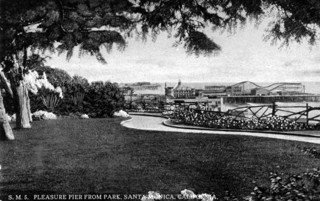
| (1922)* – Postcard view showing the Santa Monica Pleasure Pier from Palisades Park. Part of Ocean Park Pier can also be seen in the background. |
 |
|
| (ca. 1922)* - View of Ocean Park beach and the Santa Monica Pier looking south from Palisades Park. The Pacific Coast Highway runs from the foreground at right into the distance at left and is lined with early-model automobiles. The right side of the road also has several beach houses and a large, two-story bath house. The beach is visible beyond the buildings at right and is full of bathers and other beach-goers. The pier is in the background and stretches across the entire image. At left are several amusement park structures, including a roller coaster and a bowling and billiards hall. |
* * * * * |
Santa Monica Pier (Loof Pleasure Pier and Santa Monica Municipal Pier Combined)
 |
|
| (1917)#^^ - View showing the Santa Monica Municipal Pier at right and the Looff Pleasure Pier at left including the Looff Hippodrome (with "Welcome" sign) and Blue Streak roller coaster. Both piers combined were also known as Santa Monica Pier. Automobiles are seen parked on along the pier as well as signs for "Fish market bait and tackle" and "Pure California orange juice." Palm trees and cannon and cannon balls can be seen in the foreground in Palisades Park. |
Historical Notes From the time the Municipal Pier was conceived, the community wished to add an amusement park to compete with the neighboring Ocean Park and Venice Piers. In 1916 Charles Looff, a famous carousel carver turned amusement entrepreneur, answered that wish by building a new, wider pier with an amusement park along the south side of Municipal Pier. Both piers combined were often referred to as Santa Monica Pier. Looff's opening day, July 4, 1917, drew over 100,000 people; the biggest crowd in the city's history.* |
 |
|
| (ca. 1922)* - View showing the Santa Monica Pier with parking lot in the foreground. The largest two structures are the wooden roller coaster and the Looff Hippodrome. |
 |
|
| (1920s)* - The Aeroscope ride on the Looff Pier in Santa Monica, to the right is the entrance to the Blue Streak Racing Coaster |
Historical Notes The Aeroscope had six boats, each boat holding six passengers. When the ride reached thirty-five miles per hour, the centrifugal force prevented its passengers from falling out. Sixty feet high and decorated with colored lights hanging from its crown and down its cables, the Aeroscope was visible at night from miles around.* |
 |
|
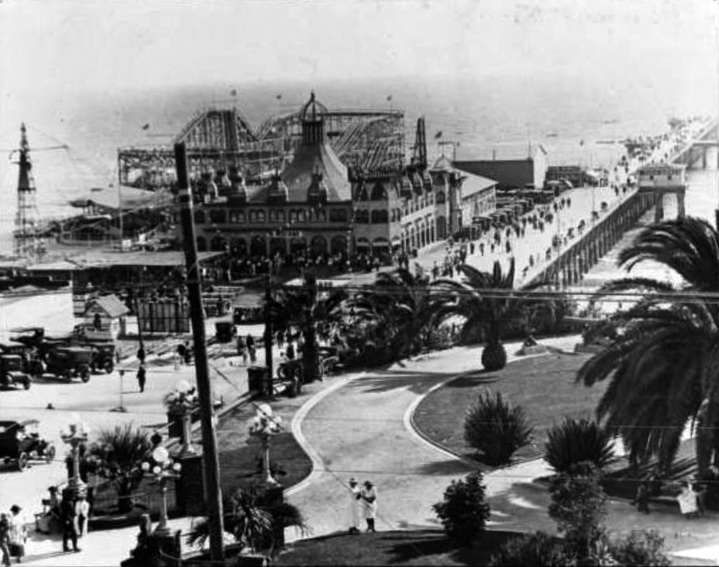
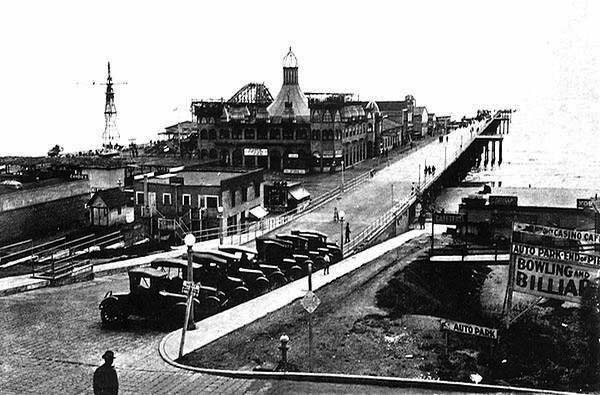
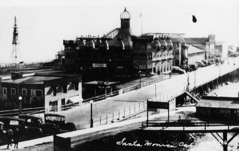
| (ca. 1922)^*## - View showing a man crossing the street heading toward Santa Monica Pier. Sign on right reads: CASINO CAFE - AUTO PARK - BOWLING AND BILLIARDS. |
Historical Notes Santa Monica has had several piers over the years; however, the current Santa Monica Pier is actually two adjoining piers that long had separate owners. The long, narrow Municipal Pier opened September 9, 1909, primarily to carry sewer pipes beyond the breakers, and had no amenities. The short, wide adjoining Pleasure Pier to the south, a.k.a. Newcomb Pier, was built in 1916 by Charles I. D. Looff and his son Arthur, amusement park pioneers. Attractions on the Pleasure Pier eventually included the Santa Monica Looff Hippodrome building (which now houses the current carousel and is listed on the National Register of Historic Places), the Blue Streak Racer wooden roller coaster (which was purchased from the defunct Wonderland amusement park in San Diego), the Whip, merry-go-rounds, Wurlitzer organs, and a funhouse.*^ |
 |
|
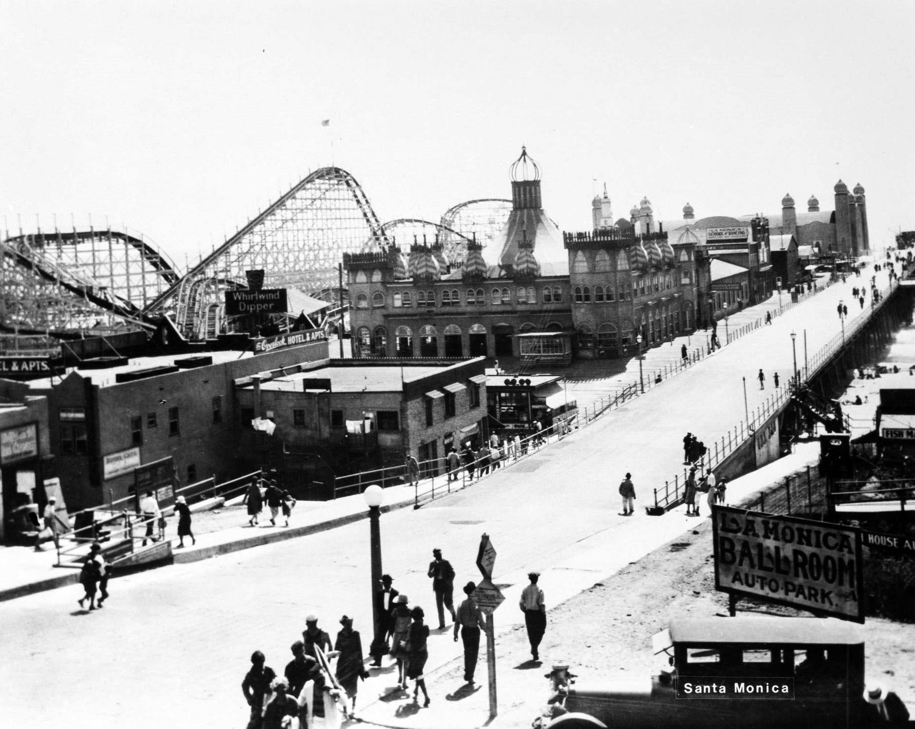
| (1924)* – Image of people walking along the Santa Monica Municipal Pier at right and the Santa Monica Amusement Pier at left. Visible on the pier are the Whirlwind Dipper roller coaster, Looff Hippodrome, and the La Monica Ballroom. With visible signs including "Whirlwind Dipper," "The Overlook Hotel & Apts., "La Monica Ballroom Auto Park," and "La Monica School of Dancing." Photo Ernest Marquez |
Historical Notes The above photo was taken shortly after the La Monica Ballroom was built at the end of the pier. Click HERE to see more. |
Santa Monica Looff Hippodrome
 |
|
| (ca. 1924)* - Closer view of the combined Municipal Pier and Loof Pleasure Pier showing the impressive Looff Hippodrome at center. |
Historical Notes TIn 1916, Charles I.D. Looff constructed a Moorish-Byzantine hippodrome on the Santa Monica Pier. It housed a merry-go-round with 44 hand-crafted horses.* In ancient Greece, the hippodrome was is an open-air stadium with an oval course for horse and chariot races or an arena for equestrian shows. |
 |
|
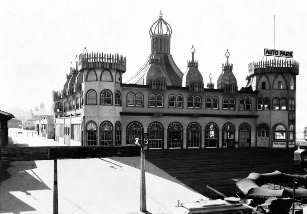
| (ca. 1920s)** - View of the Santa Monica Pier Merry-go-round. The ride is housed within a large building that resembles a castle with round turrets on the corners and domes along the tops of the walls. Arched windows run along the perimeter on both the first and second stories. A large tower that looks like the top of a circus tent rises from the middle of the building. A sign on one of the castle turrets reads "Auto Park". |
Historical Notes Charles Looff is renowned for innovating a noteworthy style of carousel horse. The moving horses were slender and graceful and inferred motion. The manes featured "cut through" openings, which looked dramatic, but where very time consuming to carve. Around 1905, Looff designed a saddle that resembled a scoop, a design that is still found on carousel horses today. +^ |
 |
|
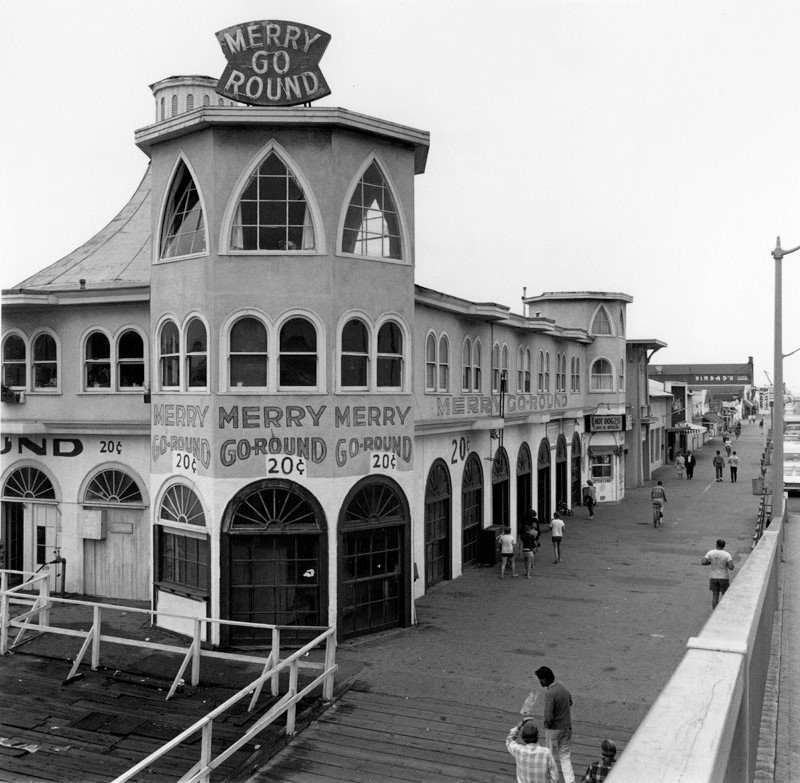
| (1966)* - Merry-Go-Round (Looff Hippodrome) on the Santa Monica Pier. Photo by William Reagh |
Historical Notes In 1987, the Santa Monica Looff Hippodrome was added to the National Registry of Historic Places. |
 |
|
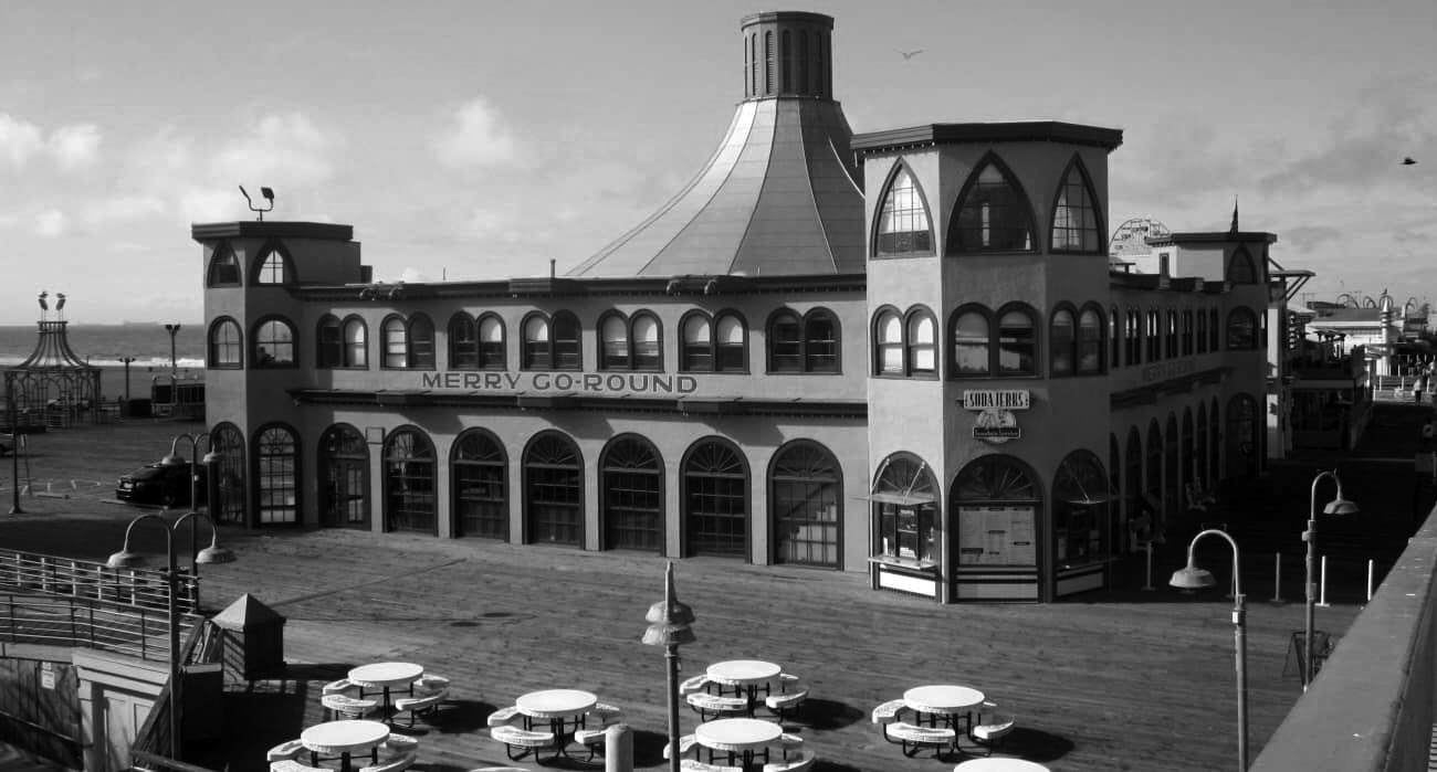
| (2020)^ - Santa Monica Looff Hippodrome as it appears today. Photo courtesy of Terry Krell Reynolds-Gallob |
Historical Notes Today, the Looff Carousel is the only original structure remaining on the Santa Monica Pier. Records do not indicate what happened to Looff's merry-go-round which was installed in the hippodrome. We do know that it was replaced by one from the old Ocean Park Pier in 1939. The current merry-go-round was built by the Philadelphia Toboggan Company in 1922; its original home was Nashville, Tennessee. The carousel arrived on the West Coast before World War II and in 1947 it was moved from Venice pier to the Santa Monica pier. It has been owned since 1977 by the City of Santa Monica. The 44 original hand-carved and painted wooden horses were restored in 1981-1984. +^ |
 |
|
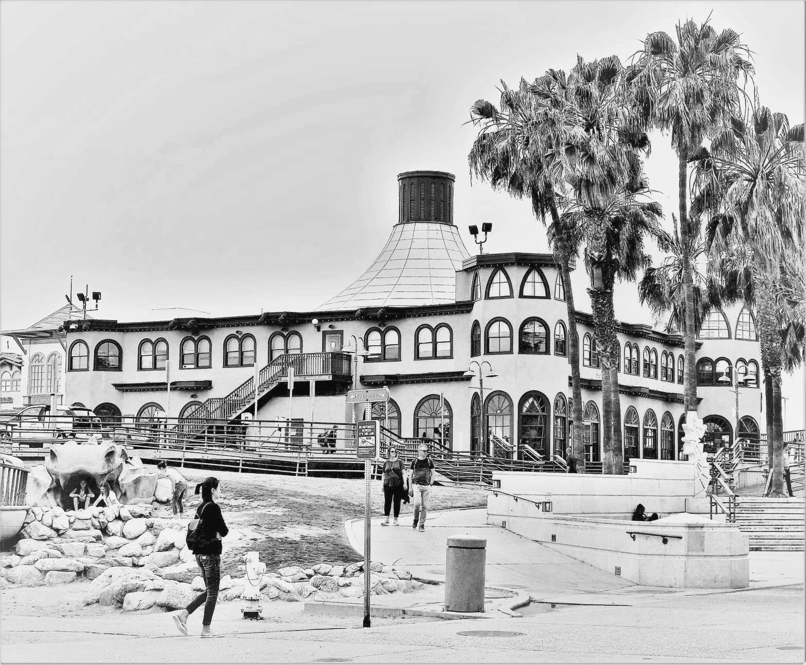
| (2021)* - Contemporary view of the Merry-Go-Round (Looff Hippodrome) on the Santa Monica Pier. Photo by Howard Gray |
* * * * * |
 |
|
| (1922)#^# – Postcard view showing Pleasure Pier in Santa Monica. Various rides can be seen on the pier including a large roller coaster. The building with the large circus-like tent on top houses the Merry-go-round. |
 |
|
| (ca. 1924)* - View shows the amusement park, complete with wooden roller coaster, on the Santa Monica pier. |
Historical Notes In additon to the hippodrome, the pier included a billiards and bowling hall, a two-track Blue Streak Racer wooden roller coaster along with The Whip and the Aeroscope thrill rides, a "What Is It?" maze, and several smaller rides.* |
 |
|
| (1924)* - Aerial view of the Santa Monica pier located on the beach in Santa Monica. An amusement park with several amusement rides is located on the pier, including a large roller coaster. Several hotels can be seen on the oceanfront of Santa Monica beach. |
 |
|
| (1924)* - Aerial view of the Santa Monica pier. Beach and buildings can be seen on the north side of the pier. |
Historical Notes Looff called this the perfect location for an amusement park, since the area was easy to access via the popular Pacific Electric Air Line as well as an electric trolley that ran from Santa Monica to Venice.*^*^* |
Pacific Electric Stations
 |
|
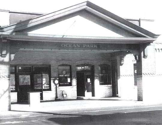
| (1920s)**#* - In the 1920s the Santa Monica line — then called the Venice via Sawtelle line — stopped at this station in Ocean Park, at Pier St. |
 |
|
| (ca. 1917)+^^ – View showing the Pacific Electric Railway Ocean Avenue depot in the foreground, with a streetcar marked "Venice" and the Looff Pleasure Pier, Santa Monica Municipal Pier and beach in distance. The Looff Hippodrome (with "Welcome" sign), "Bowling and Billiards" building, the Blue Streak Racer roller coaster, and Aeroscope rides are visible on the pleasure pier. |
 |
|
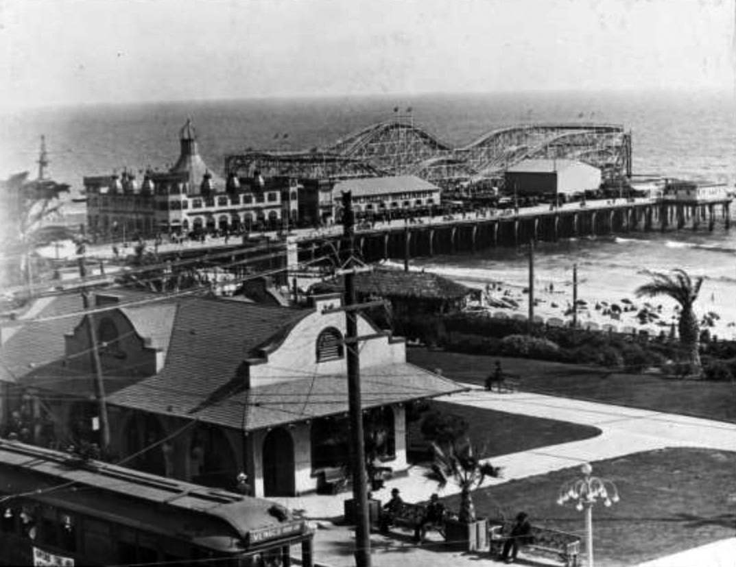
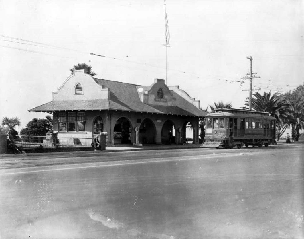
| (ca. 1922)** - Exterior view of the Pacific Electric Station in Santa Monica. The small station is at center and is a single-story Spanish-style building. Several large archways provide access to a small porch in front of the building, and tall stucco walls project out of the roof. A streetcar is visible on the tracks in front of the station. A metal fence encloses a small yard at left, and several palm trees are visible in the distance at right. A massive American flag is hanging from a pole near the train station. |
.jpg) |
|
| (1920s)#^ – View showing a Pacific Electric Railway train passing Linda Vista Station on Ocean Avenue. Banners hang from a dual-lamp light post. Click HERE to see more Early LA Streetlights. |
 |
|
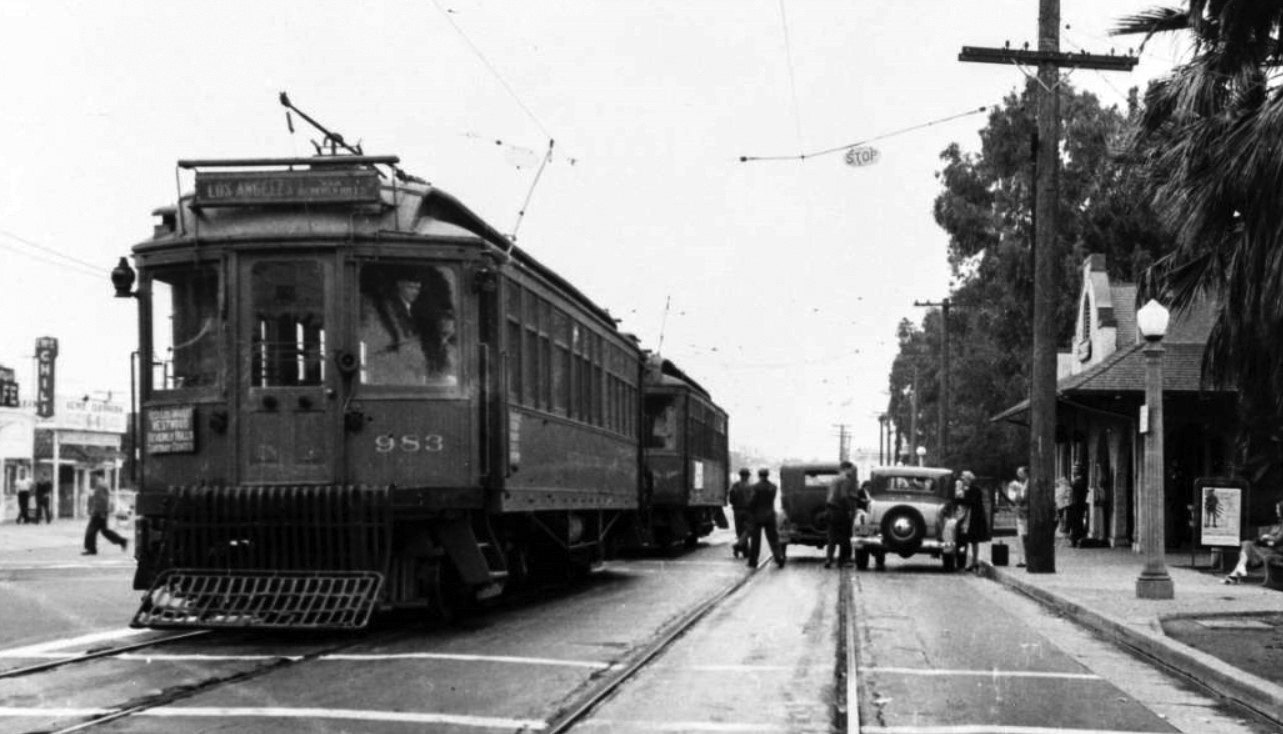
| (ca. 1930s)*– View showing Pacific Electric streetcar no. 983 at the Ocean Avenue depot in Santa Monica. Signs on the front of the streetcar read "Los Angeles vis Beverly Hills" and "West Los Angeles Westwood Beverly Hills Carthay Center." |
Historical Notes In the 1930s the Santa Monica via Beverly Hills line had the highest patronage of any inter-city or suburban line of the Pacific Electric Railway. Yet it was converted to bus operation in 1940, unlike the various PE suburban lines that survived World War II. |
* * * * * |
 |
|
| (ca. 1924)* - View of the Santa Monica Pier looking south from the Palisades Park cliff path. The pier is in the distance at center and stretches out into the ocean at right. There are several large buildings and a roller coaster on the long wooden walkway. There are several early-model automobiles making their ways up and down the incline. |
* * * * * |
La Monica Ballroom
 |
|
| (1926)*- Looking out toward the Santa Monica Pier, with the exotic La Monica Ballroom extending over the ocean at its western end. Designed in a blend of Spanish Colonial and French Renaissance styles, it was once the largest ballroom on the West Coast. |
Historical Notes Opened in July 1924 and designed by amusement architect T.H. Eslick, the La Monica Ballroom quickly became one of the most iconic dance venues on the West Coast. With domed corner towers and curvilinear gables, it evoked a seaside palace hovering above the waves. |
 |
|
| (1926)* - Colorized view of the Santa Monica Pier, showing the La Monica Ballroom with its dramatic domed towers rising above the waves. Photo by C.C. Pierce; colorization by Richard Holoff. |
Historical Notes This enhanced photo captures the exotic silhouette of the La Monica Ballroom, whose rooftop minarets and arches made it a standout along the coastline. The ballroom could accommodate up to 5,000 dancers on its massive maplewood floor, drawing crowds nightly in the 1920s. |
 |
|
| (1924)* - Early aerial looking east over the Santa Monica Pier, showing the Whirlwind Dipper, Looff Hippodrome, and the La Monica Ballroom nearing completion at the pier’s end. |
Historical Notes This 1924 photo shows the Santa Monica Amusement Pier in its prime, shortly before the La Monica Ballroom opened to 50,000 eager attendees. At the time, the ballroom was one of the largest in the world and would soon redefine nightlife along the California coast. |
 |
|
| (1924)* - Overhead view of the newly completed La Monica Ballroom sitting at the end of the Santa Monica Pier. |
Historical Notes Seen here shortly after completion, the La Monica Ballroom’s footprint dominated the western end of the pier. Its elaborate façade and rooftop domes added a new architectural grandeur to the Santa Monica shoreline. |
 |
|
| (1924)* - View looking northwest toward the Santa Monica Pier. In the foreground is the "Municipal Community Service Playground No. 2. Beyond that, crowds of people are seen looking out toward the surf. In the background stands the pier with its roller coaster and the newly constructed La Monica Ballroom. |
Historical Notes This image captures the pier during a bustling beach day in 1924, with the whimsical La Monica Ballroom rising in the distance like a Moorish castle above the Pacific. |
 |
|
| (1924)* - The elegant La Monica Ballroom perched over the ocean at the western edge of the Santa Monica Pier. |
Historical Notes The 15,000-square-foot ballroom featured a "submarine garden" interior theme and open windows for ocean breezes—creating a fantasy-like atmosphere for dancing couples above the sea. |
 |
|
| (1924)* - Autos crowd the pier during the grand opening of the La Monica Ballroom on July 23, 1924. |
Historical Notes The ballroom’s debut drew over 50,000 people, resulting in the first recorded traffic jam in Santa Monica history. The interior’s marine motif and spacious dance floor made it a sensation nearly overnight. |
 |
|
| (ca. 1920s)* - Looking back toward the Santa Monica coastline from the end of the pier, with the La Monica Ballroom in the foreground and the city’s beachside hotels rising behind. |
Historical Notes This view illustrates how the ballroom functioned as both a social and visual anchor for the pier. It served as a glamorous contrast to the stately hotels lining Ocean Avenue. |
 |
|
| (ca. 1926)*- Heavy surf crashes along the shore as the ornate La Monica Ballroom looms above the waves at the end of the pier. |
Historical Notes While the La Monica Ballroom is often described as having four minaret-topped corner towers, historical photographs show that it also featured several smaller domed cupolas along the roofline. These secondary turrets enhanced the building’s symmetry and gave it the exotic silhouette of a Moorish palace, especially when viewed from the beach or bluffs. |
 |
|
| (ca. 1927)* - Looking out to the shoreline from the Santa Monica Pier with the La Monica Ballroom seen at left. |
Historical Notes As the centerpiece of the pier, the ballroom’s massive frame offered sweeping views of both sea and shore, making it an attraction not just for dancers, but also for sightseers. |
Then and Now
 |
|
| (1927 vs Now)* - Santa Monica Pier showing the LA Monica Ballroom where the Ferris wheel is today. Contemporary photo by Lorie Vignolle-Moritz. Photo comparison by Jack Feldman. |
Historical Notes Though demolished in 1963, the legacy of La Monica lives on. The footprint once covered by its maple dance floor is now part of a modern amusement park that still entertains crowds above the surf. |
 |
|
| (ca. 1937)* - Looking out from Palisades Park towards the La Monica Ballroom on the Santa Monica Pier. Beachgoers cover the beach and many boats are docked in the bay. |
Historical Notes Though the ballroom’s dance heyday faded during the Depression, the building remained a dominant feature on the coastline, serving multiple functions including a lifeguard HQ and convention center. |
 |
|
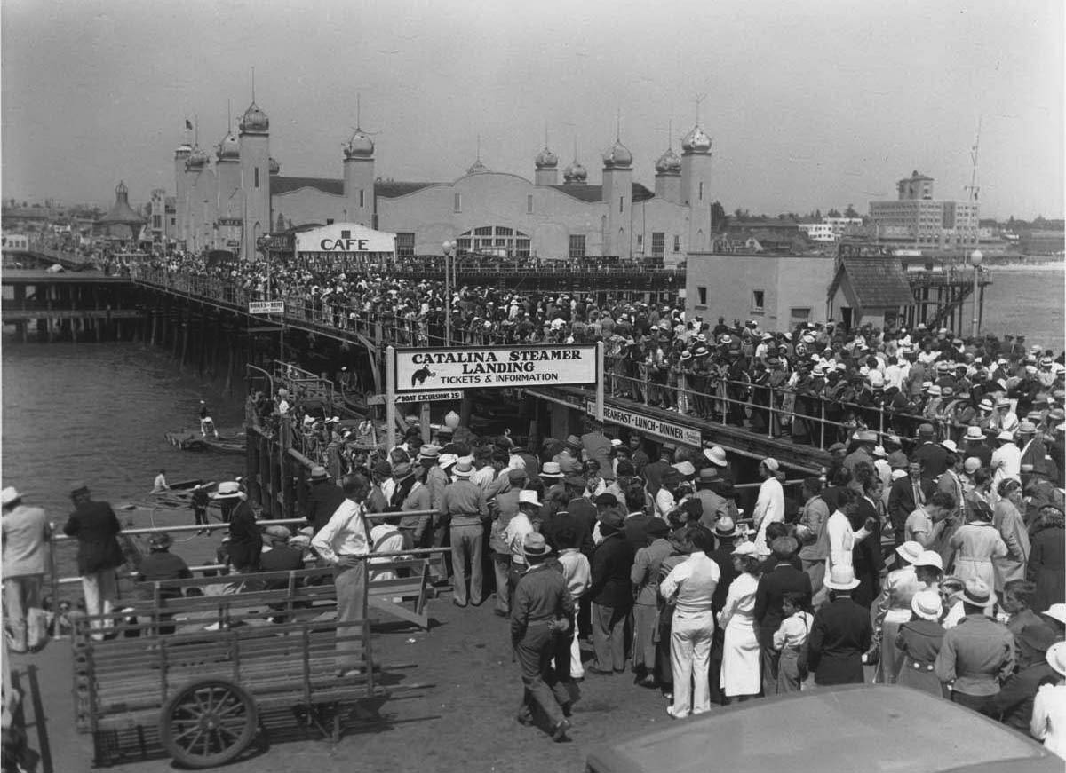
| (1936)* - Crowds of people standing in line at the Catalina Steamer Landing on Santa Monica Pier across from the La Monica Ballroom. |
Historical Notes During the 1930s, the pier also served as a passenger terminal and yacht harbor. La Monica, now repurposed, witnessed the shift from dance hall to multipurpose waterfront facility. The Thirties saw the rise of the Santa Monica Yacht Harbor. A breakwater was constructed so boats could be safely moored and to also protect the pier. A collection of yachts, fishing boats and a cruise liner to Catalina made the yacht harbor their home base. However, the breakwater was poorly engineered and began to sink into the sandy ocean floor and it is almost completely submerged today. With Marina del Rey, the worlds' largest man-made pleasure boat harbor opening in 1965 just a few miles south of the pier, signaled the end of boating activities at the Santa Monica Pier. |
 |
|
| (1936)* – Postcard view of Santa Monica Beach showing the La Monica Ballroom on the pier. A portion of the Deauville Club can be seen in lower right (opened in 1927). |
Historical Notes By this time, the ballroom was no longer hosting nightly dances but remained a landmark structure amid the evolving beachscape and social clubs along the coast. |
 |
|
| (ca. 1930)* – The Santa Monica Deauville Club in the foreground, with the La Monica Ballroom rising in the distance above the pier. |
Historical Notes As elite beach clubs sprang up along the coast in the late 1920s, La Monica continued to be a popular public venue—bridging the divide between exclusive leisure and mass entertainment. |
 |
|
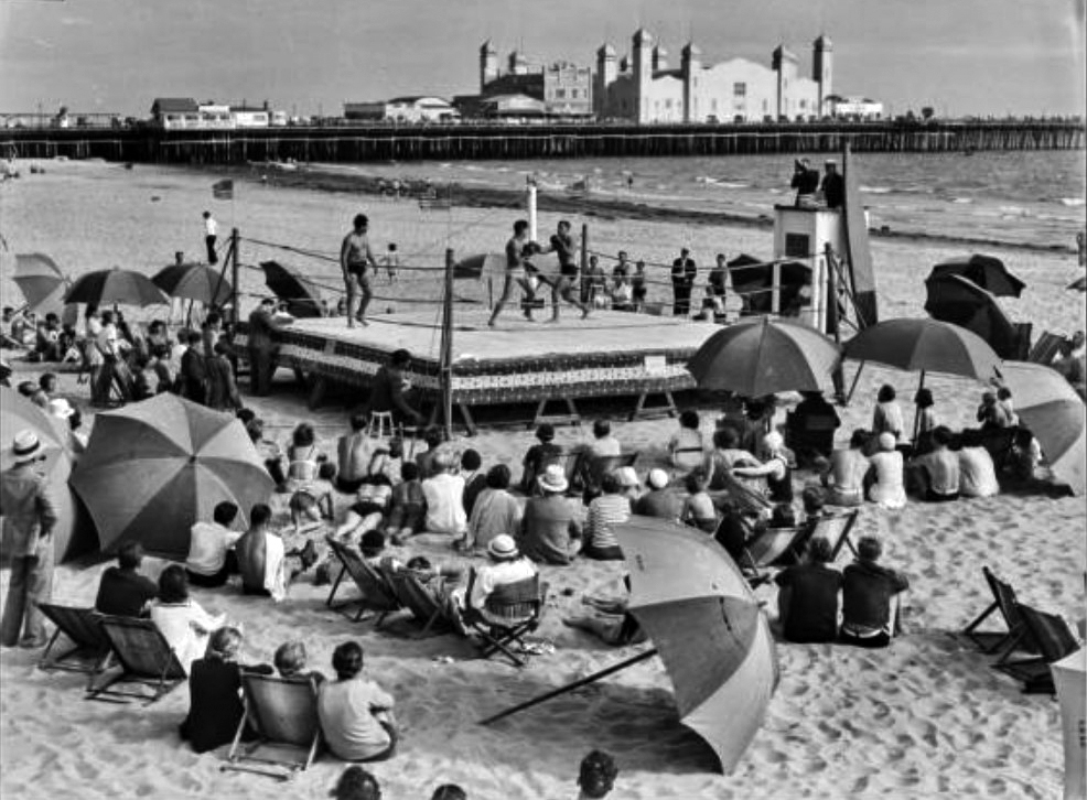
| (ca. 1934)* - Image of a crowd amid beach umbrellas watching two pugilists boxing in an outdoor boxing ring on the beach in front of the Santa Monica Athletic Club. The Santa Monica Pleasure Pier with the La Monica Ballroom and Municipal Pier are in the background. |
Historical Notes As its dance hall fame declined, the La Monica Ballroom stood witness to a new era of beachside attractions, civic events, and sports exhibitions—all reshaping Santa Monica’s identity during the Depression. |
* * * * * |
Venice Trams (Between Venice and Santa Monica)
 |
|
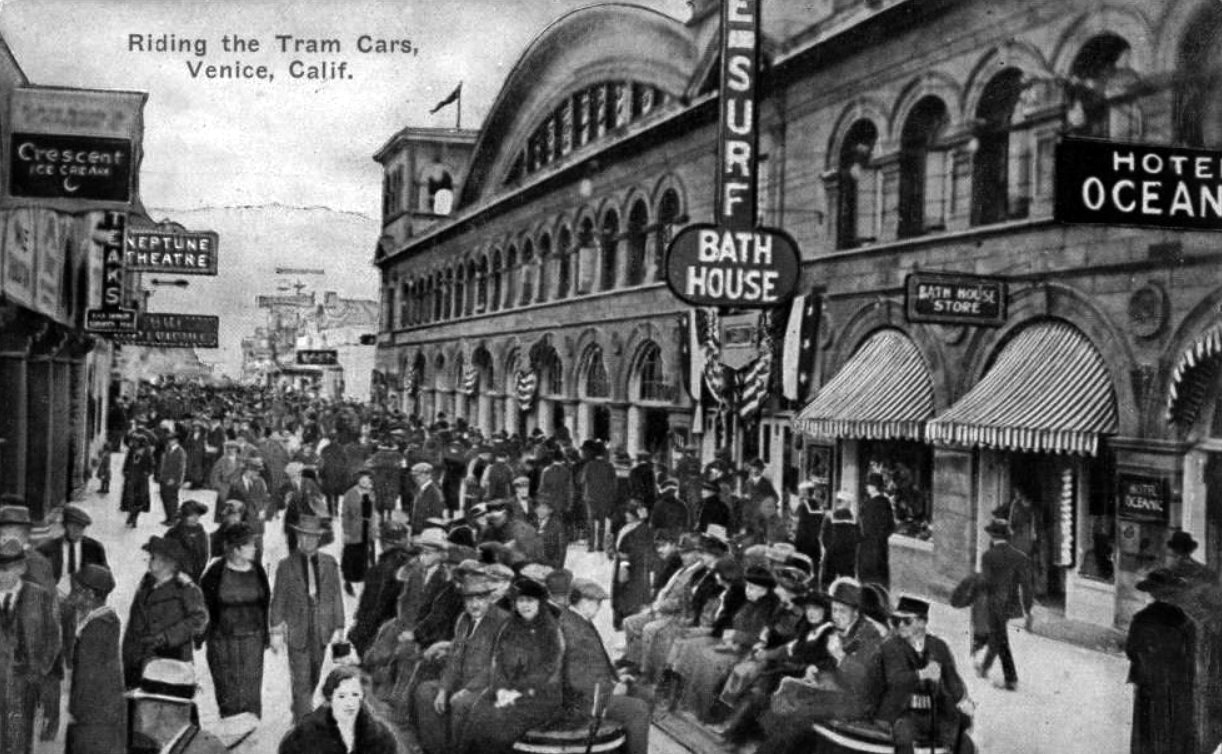
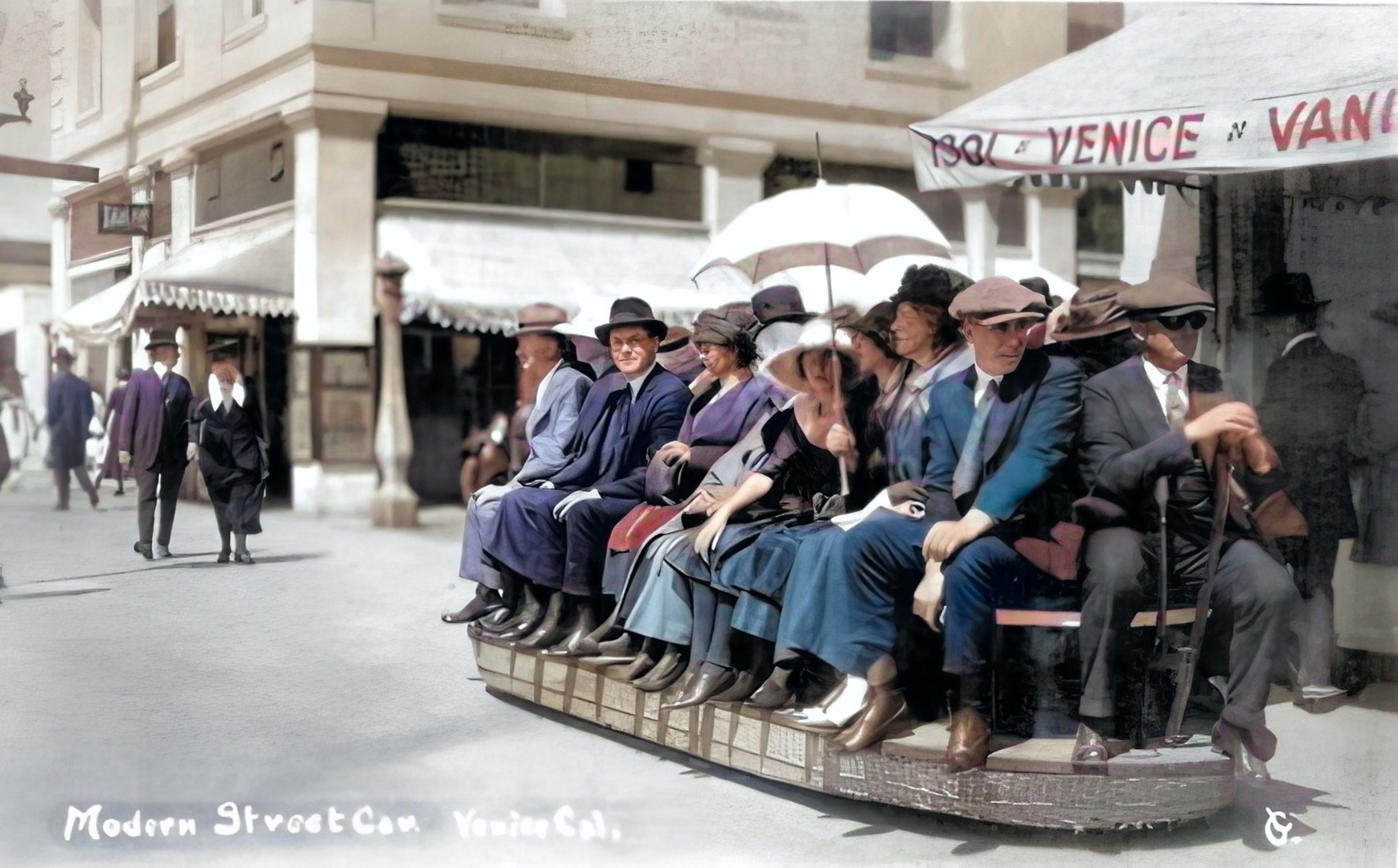
| (1910s)* – Postcard view of ‘Riding the Tram Cars’, Venice, Calif. |
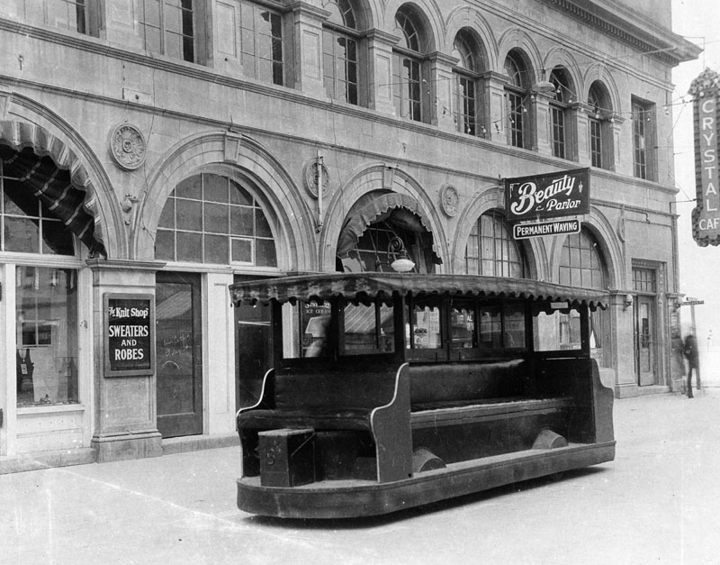
Historical Notes The Venice trams were operated by a uniformed motorman along a north and south route on the concrete boardwalk between Santa Monica and Venice. These trackless electric trams amounted to battery powered upholstered wicker benches with lever type hand controller and mechanical brake at one end. The electric trams operated between 1916-1929. By the 1930s, the trams had 4 cylinder, Ford model A engines. |
 |
|
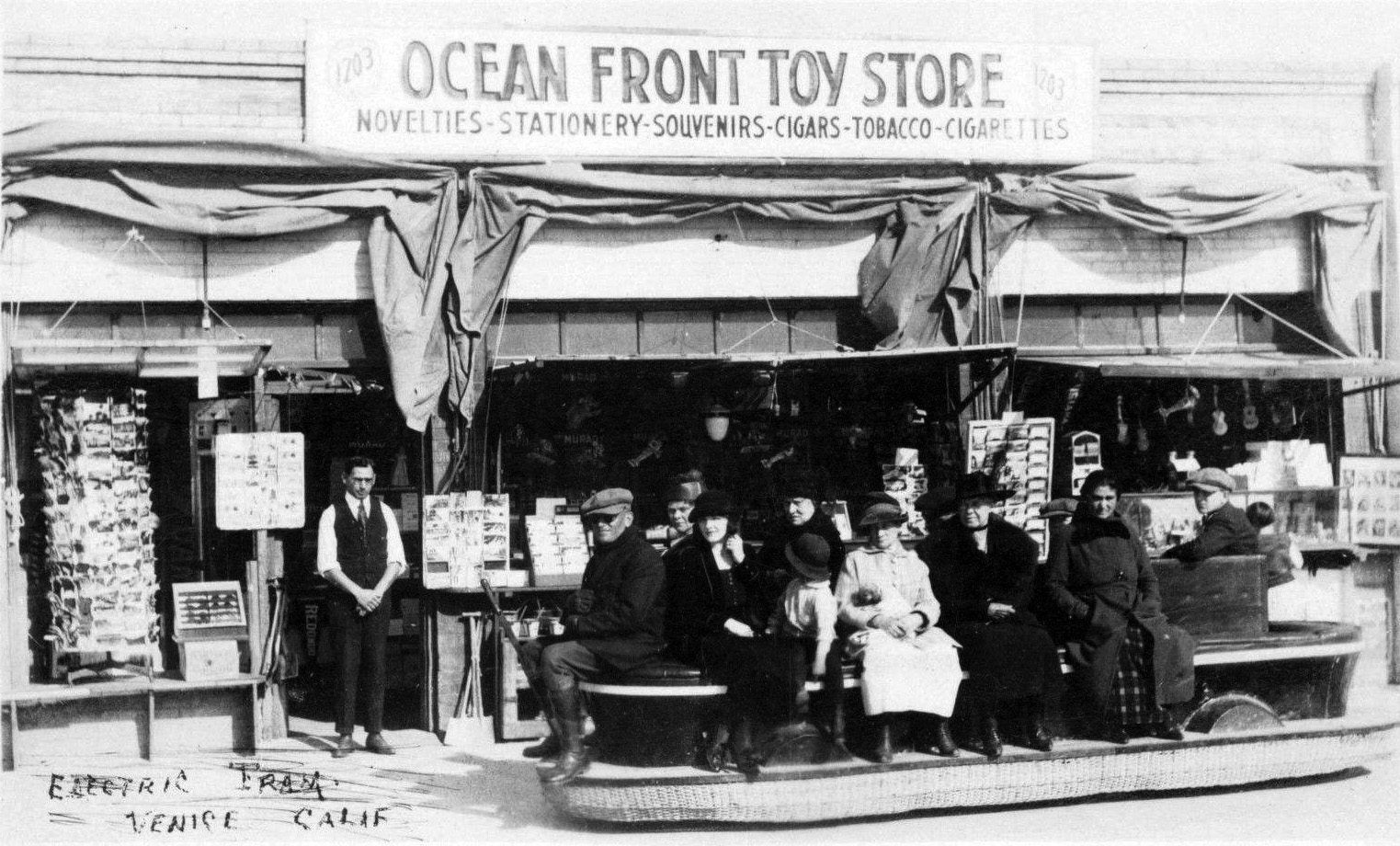
| (ca. 1916)* - Electric tram ride on the Ocean Front with Ocean Front Toy Story in the background. |
Historical Notes The conductor of this tram would switch end positions at Santa Monica to drive it back to Venice. There was no feature that allowed for turnaround. And there was also nothing to protect passengers from the hot sun overhead. |
 |
|
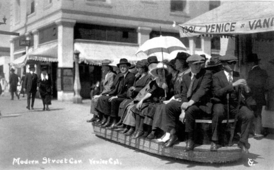
| (ca. 1910s)* – Postcard view showing one of the first generation electric trams that ran from Venice to Santa Monica. Photo courtesy of Sarah and John Schacht. |
 |
|
| (ca. 1910s)* – Postcard view showing one of the first generation electric trams that ran from Venice to Santa Monica. Photo courtesy of Sarah and John Schacht. Image enhancement and colorization by Richard Holoff. |
 |
|
| (1920s)* - View showing a 2nd generation tram sitting on the Venice sidewalk/street, This open sided electric tram had an awning above and room for seating on all sides. |
 |
|
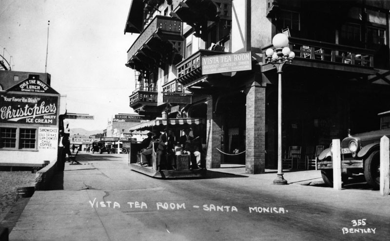
| (1920s)* - Exterior view of the Vista Tea Room in Santa Monica. On the left is a small building called Over the Waves Lunch, and the Seaside Novelty can be seen in the background. An electric tram moves people along the walkway. |
 |
|
| (1920s)* – View showing an electric tram heading north on Ocean Front Walk in front of Seaside Park (present day Crescent Bay Park). |
Historical Notes Electric tram service on Ocean Front Walk between Venice and Ocean Park began operation in 1916. By 1920 the trams were electric battery powered. They ran from Windward Ave. and the Venice Pier, to the Ocean Park Pier, and then to the Santa Monica Pier, and back. In 1923, the Venice Tram Company was formed. |
 |
|
| (1930s)* - Postcard of a tram running between Venice, Ocean Park, and Santa Monica. The Ocean Park Plunge can be seen in the background. |
Historical Notes By the 1930s, the trams had 4 cylinder, Ford model A engines and canopy tops. There were also similar 4 cylinder, Chevy engines. The seats faced toward the ocean or shops plus it had a back seat. |
 |
|
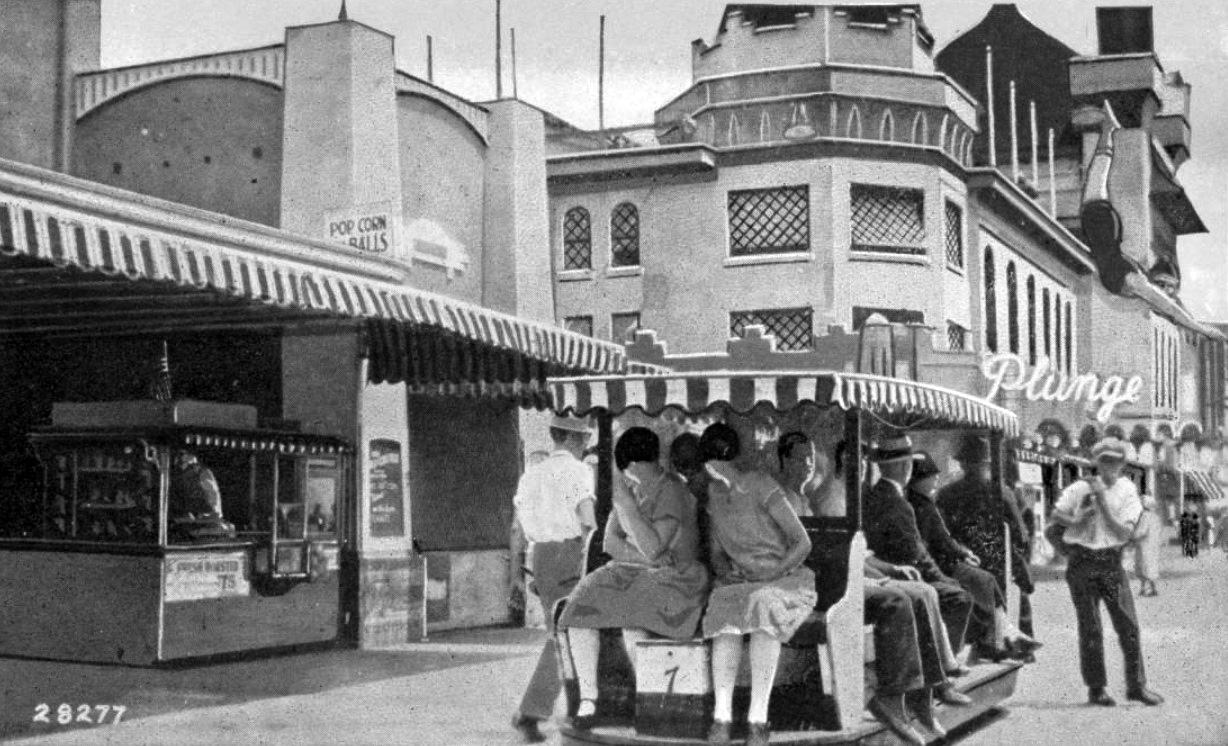
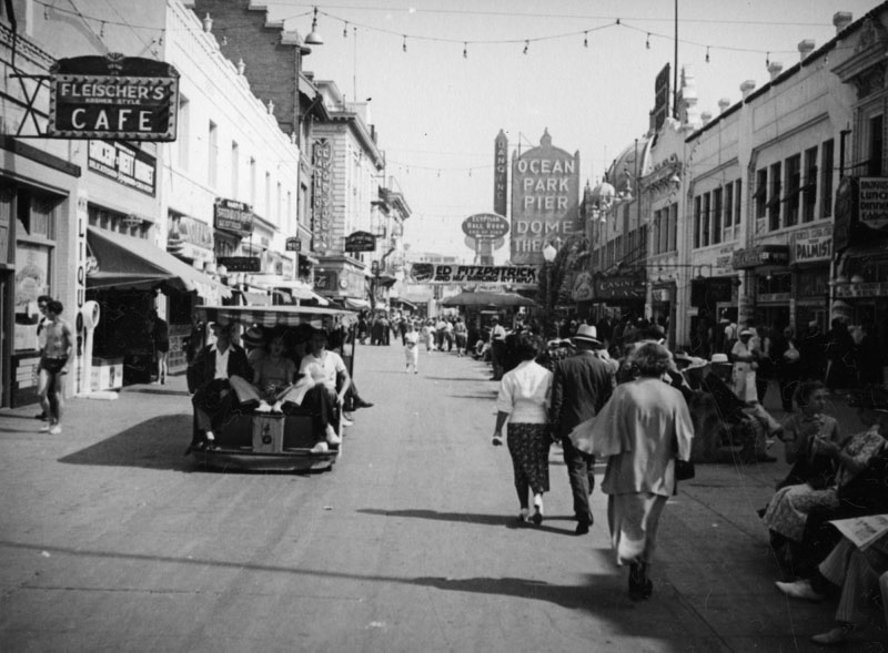
| (1920s)* - Crowds of people and an electric tram are seen in the fun section of the pier. A large sign hangs at far end of the street announcing Ed Fitzpatrick and his Dancing Rhythms. Also seen are signs for Feisher's Cafe (left) and the Dome Theatre (far back on the right). An electric tram can be seen transporting a full load of passengers down the walkway. |
* * * * * |
1st Dome Theatre
 |
|
| (ca. 1922)^ – View showing the original Dome Theatre located on Ocean Front Walk in Venice. |
Historical Notes The first Dome Theatre was originally a dance hall that had opened on July 4, 1916. The building was constructed on the Great Western pier at Ocean Front Walk. The location at the northwest corner of Ocean Front Walk and Navy Ave. is just south of the Santa Monica city limits. In the 1923-24 directory it's listed as 3034 Ocean Front Promenade, Venice. The main space was a 100 foot concrete dome. It was converted into a theatre in 1922 when the Lick Pier was constructed. The Lick Pier was constructed seaward of the dance hall, just south of the Fraser/Pickering Pier (aka Ocean Park Pier) that was the original location of the Rosemary Theatre. |
 |
|
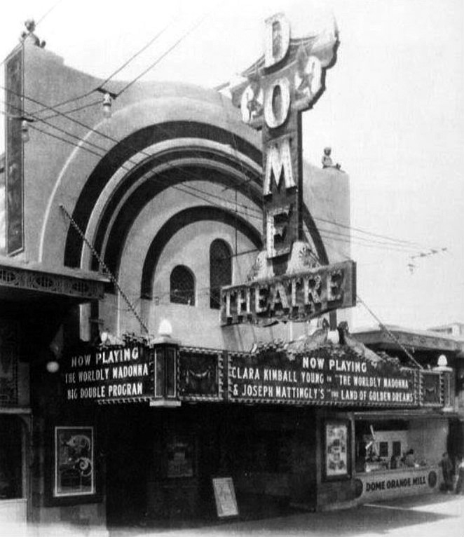
| (1923)* - View showing the marquee and dome of the first Dome Theatre. The show playing is Priscilla Dean in "White Tiger." The theater burned down in 1924, but was rebuilt a year later. |
 |
|
| (1924)^ – View of the first Dome Theatre burning. |
Historical Notes Demolished after a fire on January 6, 1924. The building was a total loss except for the entrance portion of the structure. This was used with a new building behind and became the new Rosemary Theatre. In addition to the Dome Theatre, the fire consumed the adjacent Ocean Park and Lick Piers. |
2nd Dome Theatre and Entrance to Ocean Park Pier
 |
|
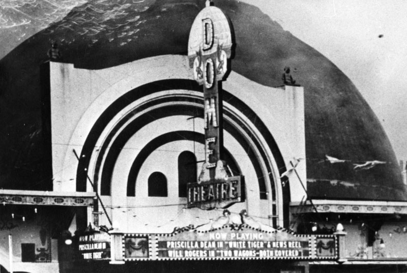
| (1925)* - View showing the newly completed 2nd Dome Theatre with signage advertising Orpheum Vaudeville on the Weekends. The big dome straddled the entrance to the pier and was not part of the theatre itself. |
Historical Notes West Coast Theatres and the Venice Investment Co. acquired the assets of the Pickering and Lick Pier Pier operating company two weeks after the 1924 fire. After difficult negotiations with the city of Santa Monica, they rebuilt the pier including a new Dome Theatre. The new Dome Theatre was just a few doors north of the original location. |
 |
|
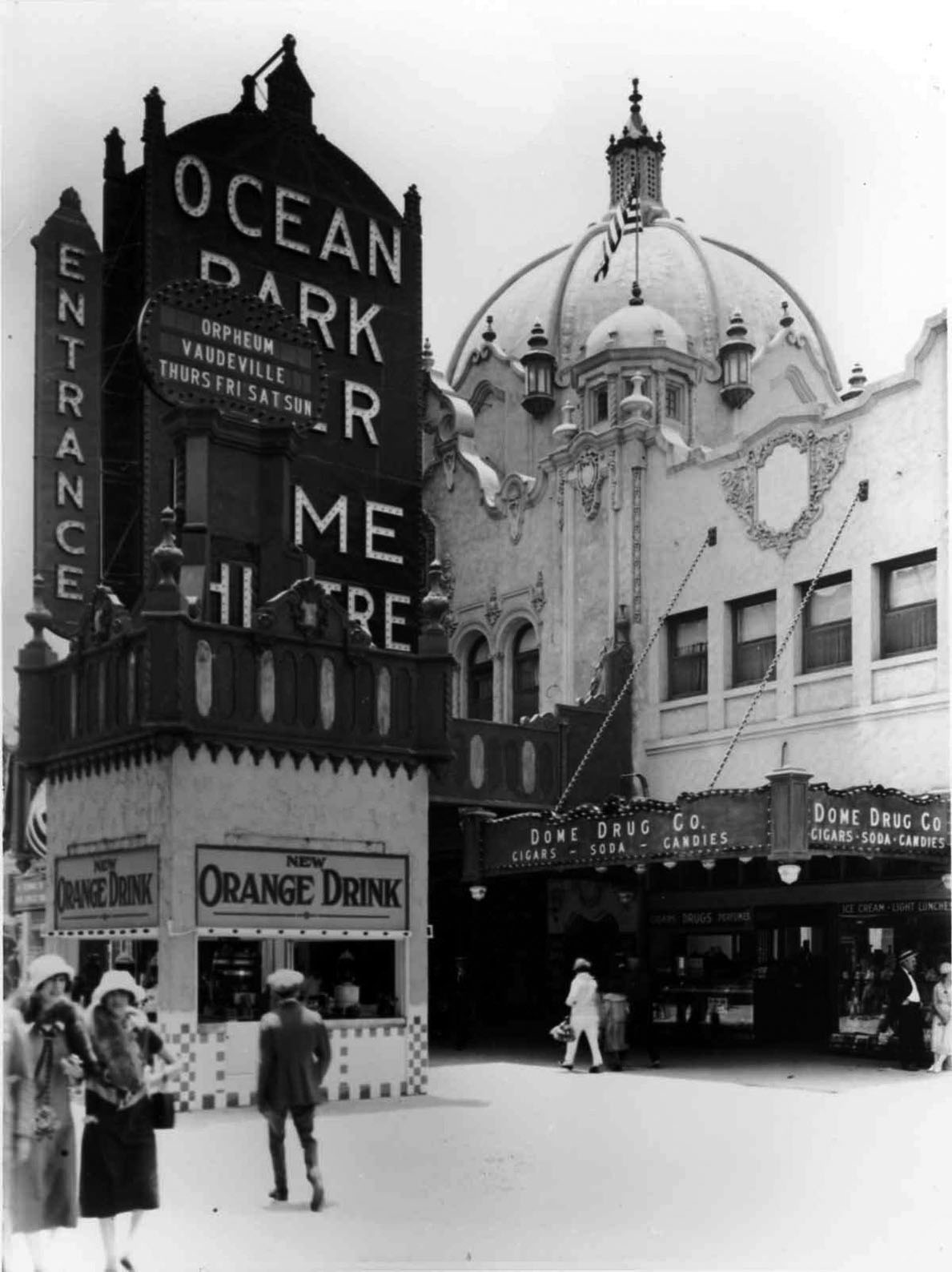
| (ca. 1925)* - Close-up view showing the newly constructed 2nd Dome with the Dome Theatre to the left out of view. Also seen here is the Dome Drug Co. store. |
Historical Notes Note that the prominent decorative dome in the new construction is not the theatre, but the entrance to Ocean Park Pier. The theatre itself was just to the south of the dome. |
 |
|
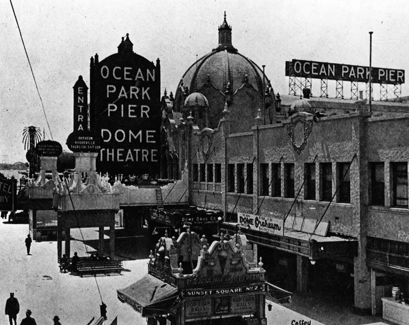
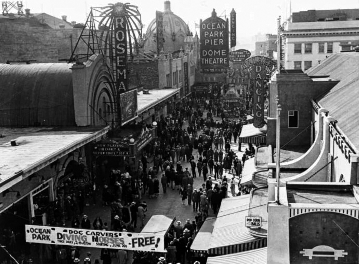
| (1927)^ - Image of a crowd of people on the Ocean Front Walk next to the Ocean Park Pier in Santa Monica, California. There is a banner in the foreground for "Ocean Park Doc Carvers Diving Horses- Free staritng June 26" and the marquee on the Rosemary Theater at left reads "Now playing Lon Chaney & Preview Tonite" with a poster for the movie "The Unknown." Additional signs include "Dancing", "Ocean Park Pier Dome Theatre", and "Egyptian Ball Room." |
Historical Notes The Dome's place in history is assured as it is the theatre where the Mickey Mouse Club fad began there in 1929. It was part of a matinee promotion by manager Harry Woodin. |
 |
|
| (ca. 1925)^ – Policemen walk the beat on Ocean Front Walk with the Ocean Park pier entrance and Dome Theatre in the background. Further in the distance can be seen the Ocean Park Bath House with its Moorish-style domes. |
 |
|
| (ca. 1935)* – Photo titled Ocean Park Pier amusement zone in Santa Monica, with the Dome Theatre seen in the background. William M. McCarthy Photograph Collection |
 |
|
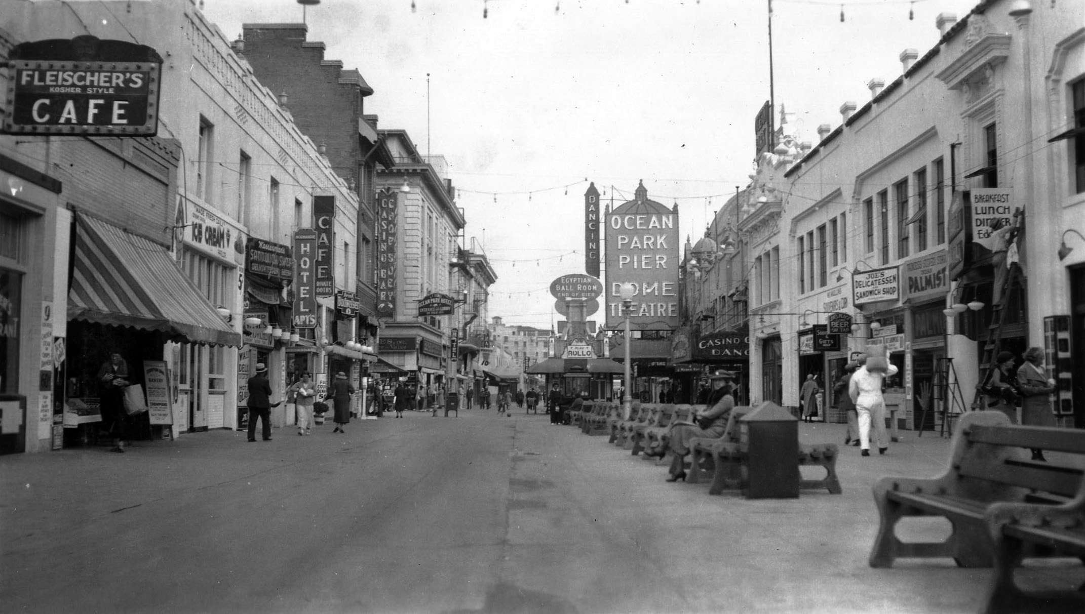
| (ca. 1935)* – Looking down Ocean Front Walk with the Ocean Park pier entrance and Dome Theatre in the background. Fleischer’s Kosher Style Café is seen on the left. Photo credits: California State Archives, William M. McCarthy Photograph Collection; AI image enhancement and colorization by Richard Holoff |
* * * * * |
Wing-Walking over Santa Monica Bay
 |
|
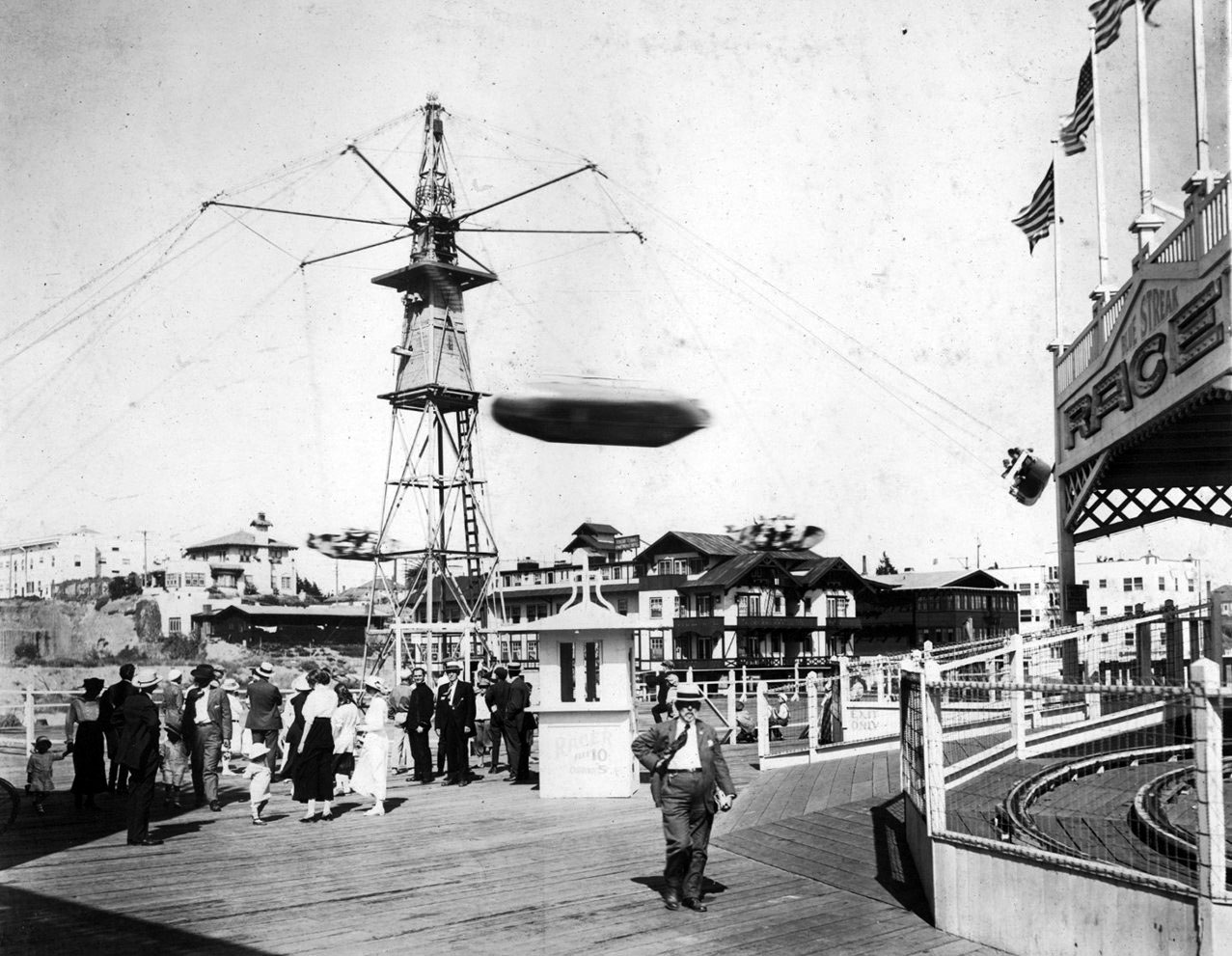
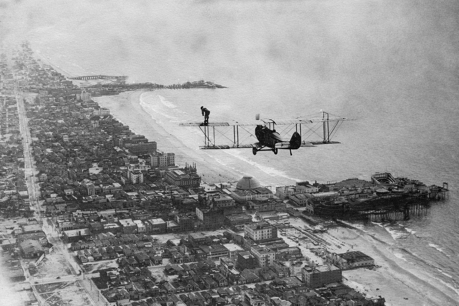
| (1918)* - Walking over Santa Monica. A Curtiss JN biplane flies low over Santa Monica Bay as a woman stands upright on the wing, looking down at the shoreline below. Ocean Park Pier and its amusement park appear directly beneath the aircraft, while Venice Pier is visible farther south in the distance. |
| Historical Notes
This photograph was taken on August 14, 1918, and shows an early aviation stunt known as wing-walking. The woman standing on the wing is Babe Kalishek, one of the most skilled and well-known female aerial performers of the time. The Curtiss JN biplane is flown by experienced aviator Jim Hester. Wing-walking combined flying and acrobatics at a time when airplanes were still new and risky. Performers moved across the wings and struts of open airplanes without safety harnesses, relying on balance and strength while the plane stayed in flight. These stunts were meant to impress crowds and build excitement about aviation. Santa Monica Bay was a perfect setting for these displays. Large crowds gathered along the coast and on the piers below, especially at Ocean Park and Venice. The aircraft in this photo flies directly over Ocean Park Pier, with Venice Pier visible farther south. The same people who came for rides and amusements also looked up to watch aviation performances, linking early flight with the rise of the great piers along Santa Monica Bay. |
* * * * * |
Piers of Santa Monica Bay
| Historical Notes
From the early 1900s through the 1930s, Santa Monica Bay had one of the largest concentrations of piers on the West Coast. Built during a time of rapid growth in Southern California, these piers served different purposes. Some were designed for amusement and crowds, while others supported fishing, boats, and everyday coastal work. Together, they transformed the shoreline into a busy and competitive coastal zone that would not last beyond the Depression years. |
 |
|
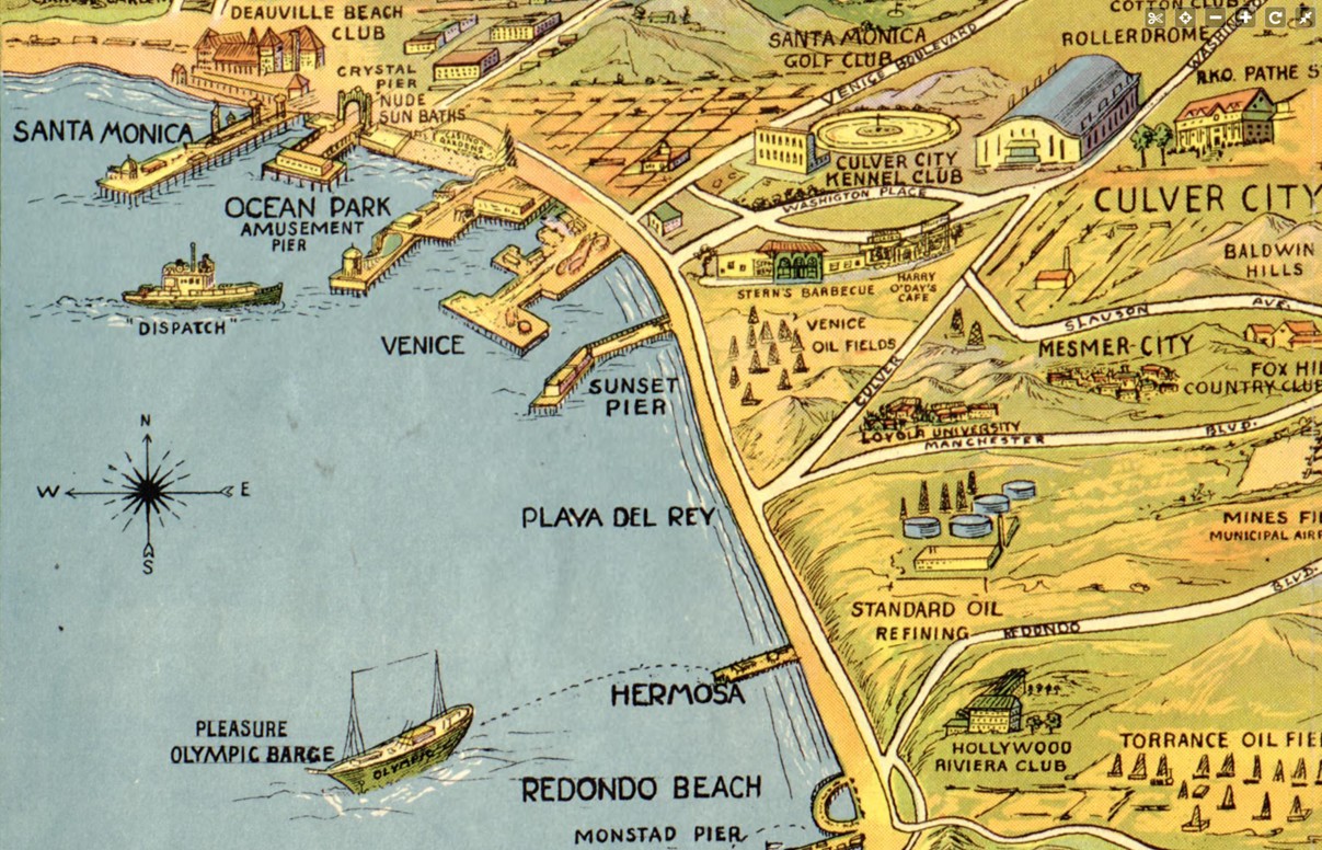
| (1932)* - Map showing the piers of Santa Monica Bay. The coastline is dotted with multiple piers stretching from Santa Monica south toward Redondo Beach. A structure labeled Monstad Pier appears near Redondo Beach at the lower right. |
Historical Notes The 1932 map shows Santa Monica Bay as a coastline shaped by piers, with the greatest concentration around Santa Monica, Ocean Park, and Venice. These neighboring communities actively competed for visitors, which is why their large amusement piers appear most prominently and are the best documented. The map should be read as a snapshot of what was considered active and important at the time, rather than a complete record of every pier along the coast. Smaller and more practical piers were less likely to be emphasized, especially those built for work rather than entertainment. Near Redondo Beach, the map identifies a pier labeled Monstad Pier. Built in the 1920s by Captain Hans C. Monstad, it served fishing boats and small craft instead of crowds and rides. Its limited size and working purpose help explain why it is less well known today, even though parts of it are often described as having been incorporated into later Redondo pier structures. |
 |
|
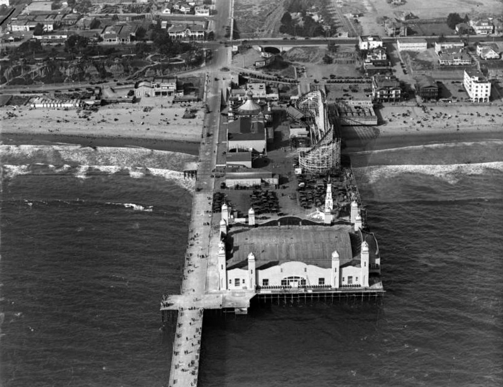
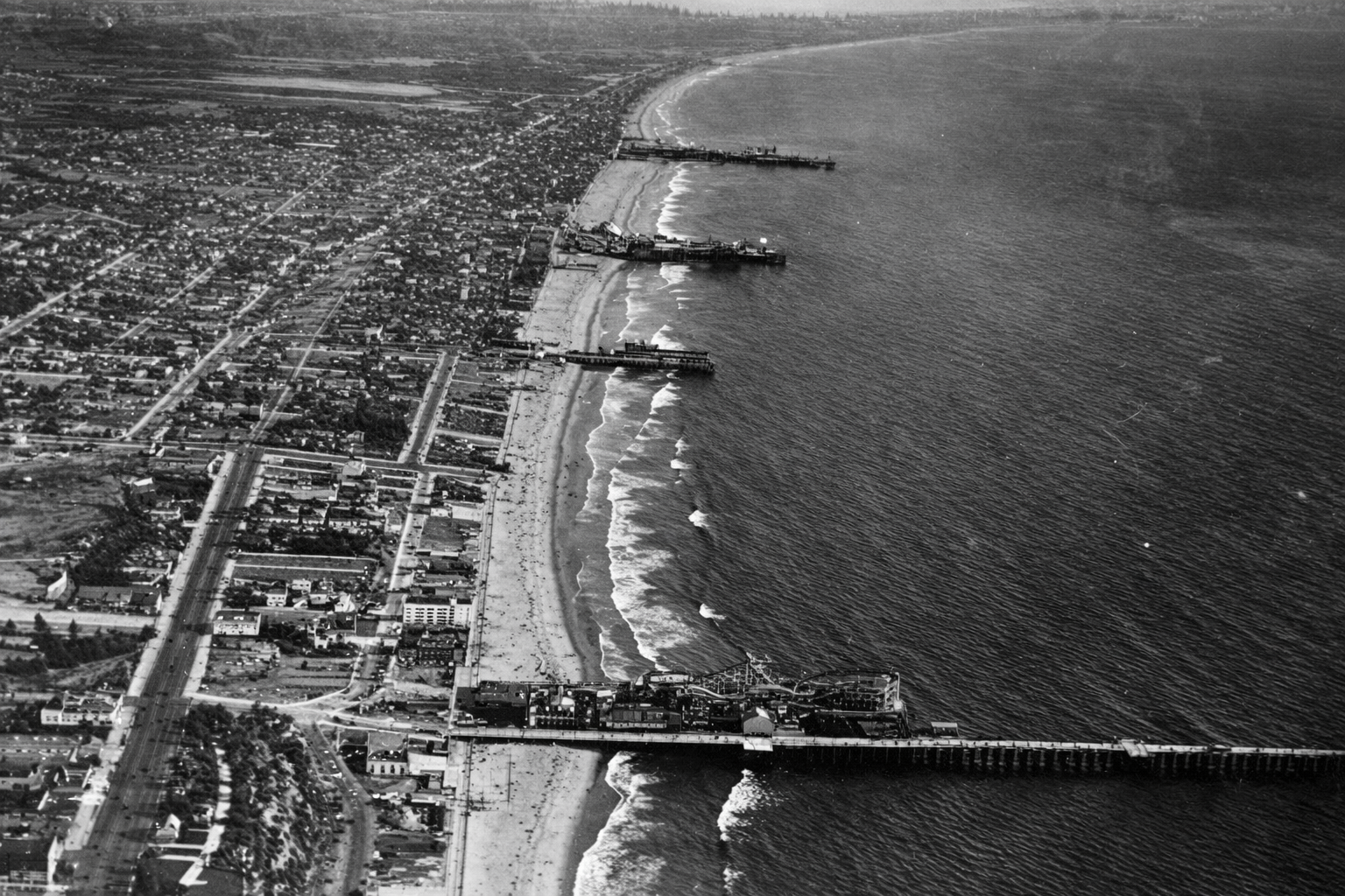
| (1919)* – Aerial view looking south showing four Santa Monica Bay piers, from bottom to top: Santa Monica Pier, Crystal Pier, Ocean Park Pier and Venice Pier. |
Historical Notes This aerial view captures the height of the amusement pier era. Improved transportation, especially electric rail lines, allowed visitors from across the Los Angeles region to reach the coast easily. As a result, pier owners competed fiercely to attract crowds with ever larger rides, brighter lights, and more ambitious attractions. The close spacing of these piers created an almost continuous entertainment zone along the shoreline. Fires, storms, and structural failures were common because the piers were built almost entirely of wood, but destruction rarely marked the end. Piers were often rebuilt larger and more elaborate than before, reflecting both optimism and strong public demand. |
 |
||
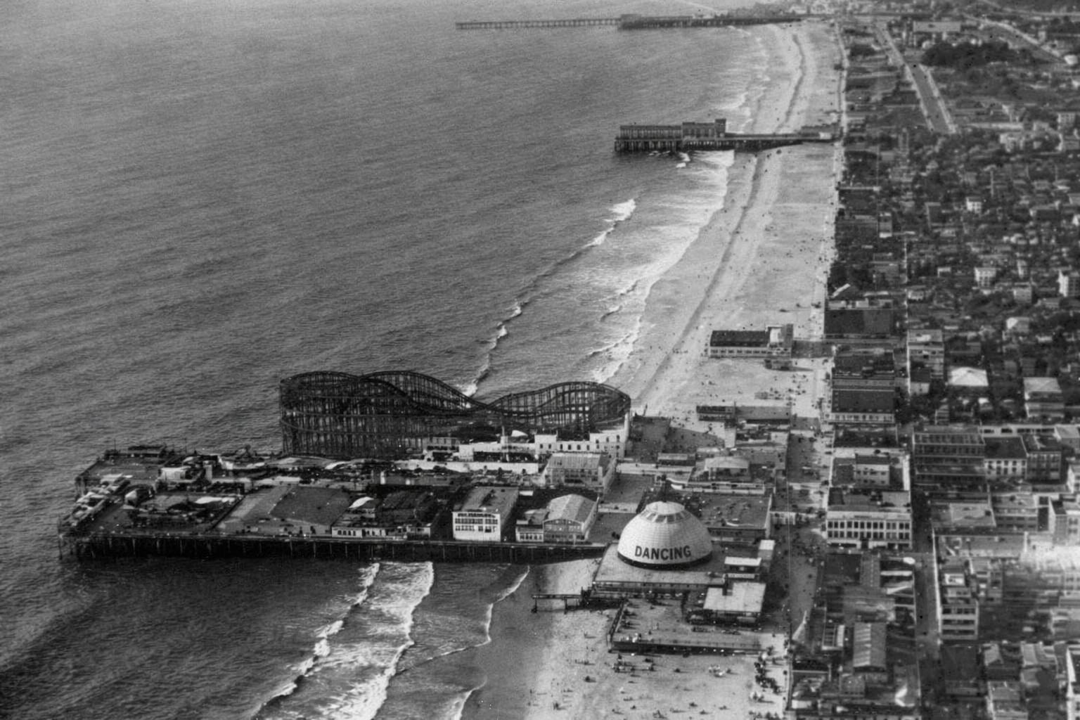
| (1920s)* - Aerial view looking north all along the coast of Venice and the whole Santa Monica Bay area. At least 6 or 7 piers can be seen extending out into the ocean. Venice Pier and amusement park can be seen in the foreground. Ocean Park Pier, with its own amusement park, is the next pier over. Beyond that, the long pier at the top of the photo, is the Santa Monica Pier. It also had an amusement park. |
Historical Notes During the 1910s and 1920s, Venice, Ocean Park, and Santa Monica functioned as direct competitors rather than separate beach towns. The three amusement piers were located within roughly a mile and a half of each other, each offering roller coasters, games, food, and spectacles designed to outdo the others. Between 1904 and 1925, at least fourteen roller coasters were built along this stretch of coast. The shoreline became a constantly changing landscape of rides, lights, and crowds, making Santa Monica Bay one of the most intense amusement zones in the country. The density seen here would never be repeated after the Great Depression. |
 |
|
| (1920)* - Aerial view of Ocean Park Pier showing its large roller coaster. The long pier to the north (top of photo) is the Santa Monica Pier. It too had its own amusement park starting in 1916. In between the two longer piers is the shorter Crystal Pier (originally White Star Pier then Bristol Pier). |
Historical Notes Ocean Park Pier was one of the most heavily developed amusement piers on the bay, featuring large rides that rivaled those found at Santa Monica and Venice. Roller coasters were the main draw, but the pier also offered arcades, food concessions, and gathering spaces that encouraged visitors to linger. The proximity of multiple piers allowed visitors to experience several amusement districts in a single day. Crystal Pier, though smaller, played an important supporting role in this landscape. Together, these piers formed a layered recreational environment where scale and spectacle mattered as much as location. |
 |
|
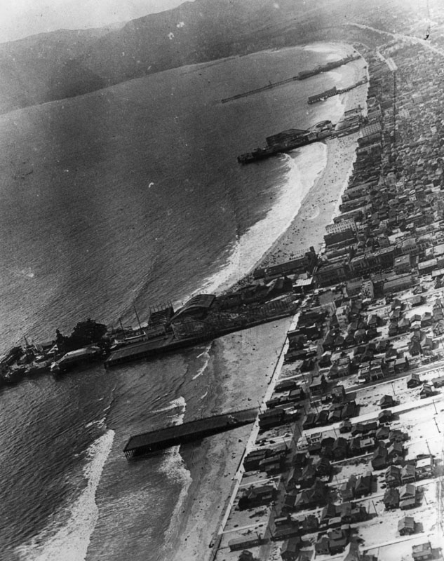
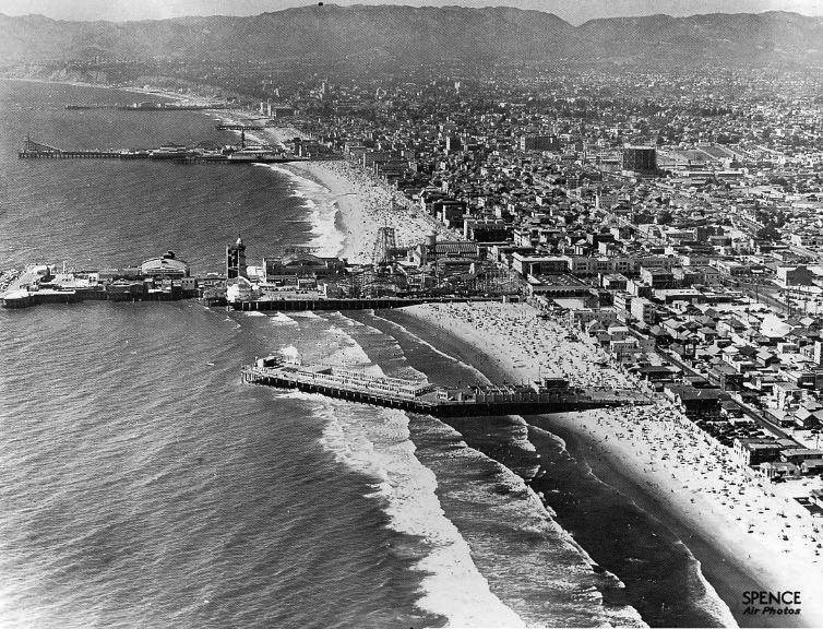
| (ca. 1930s)* – Aerial view showing the pleasure piers of Venice and Santa Monica. From bottom to top: Sunset Pier, Venice Pier, Ocean Park Pier, Crystal Pier, Santa Monica Pier…all that remains are the rocks of the breakwater behind the Venice Pier and the Santa Monica Pier. Photo taken by Spence Air Photos. |
Historical Notes This image captures the end of the amusement pier era along Santa Monica Bay. Economic pressures from the Great Depression, combined with repeated storm damage and changing recreational habits, led to the gradual disappearance of most piers. Some were dismantled, others burned or collapsed, and many were simply not rebuilt. By the late 1930s, the once-crowded shoreline had thinned dramatically. The survival of the Santa Monica Pier was the exception rather than the rule, making it a rare physical link to a period when the bay was defined by wooden structures reaching into the sea. This transition marked a broader shift away from mass amusement toward quieter, more observational uses of the coast. |
 |
|
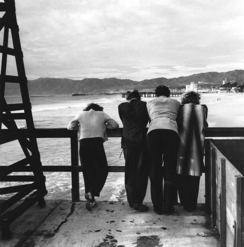
| (ca. 1940)* - Four people are seen on Ocean Park Pier, looking north towards the heart of Santa Monica and both Crystal Pier and Santa Monica Pier. Photo by Ansel Adams. |
Historical Notes This quiet scene contrasts sharply with the crowded amusement views of earlier decades. By 1940, Ocean Park Pier was nearing the end of its life, and much of the surrounding entertainment district had faded. The photograph emphasizes scale, distance, and atmosphere rather than spectacle. Ansel Adams’ image reflects a shift in how the coastline was experienced and recorded. The pier becomes less a site of mass entertainment and more a place of observation and reflection. Within a few years, Ocean Park Pier would be gone, leaving images like this as some of the last visual records of its existence. |
* * * * * |
Venice Pier
 |
|
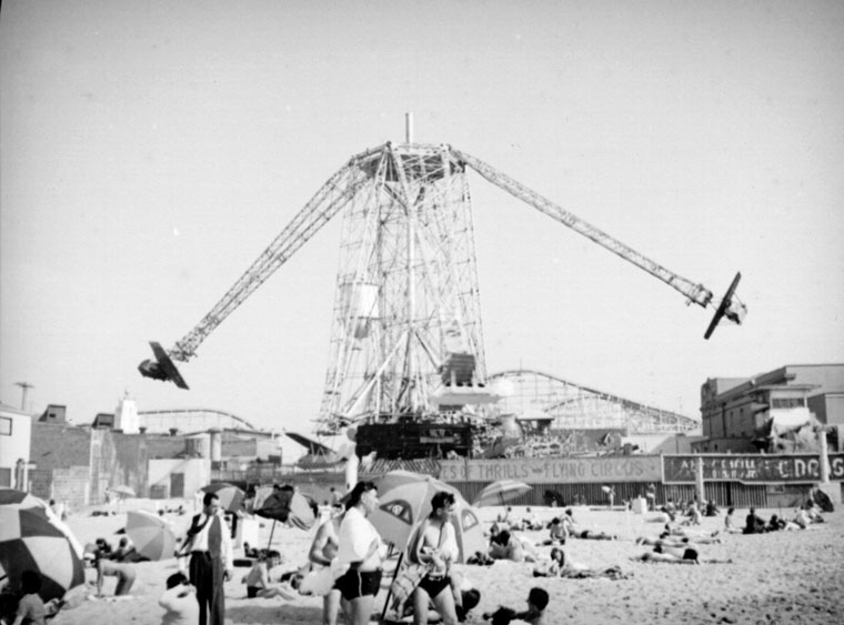
| (ca. 1925)* - Two airplanes rotating around the center tower on the Venice amusement park ride are visible. This ride, called the Flying Circus has 6 to 8 passenger cars circling the main tower 65 feet above the peer. Seen here from the sandy beach in the foreground. |
Historical Notes Click HERE to see more Early Views of Venice Amusement Pier. |
Ocean Park Pier
 |
|
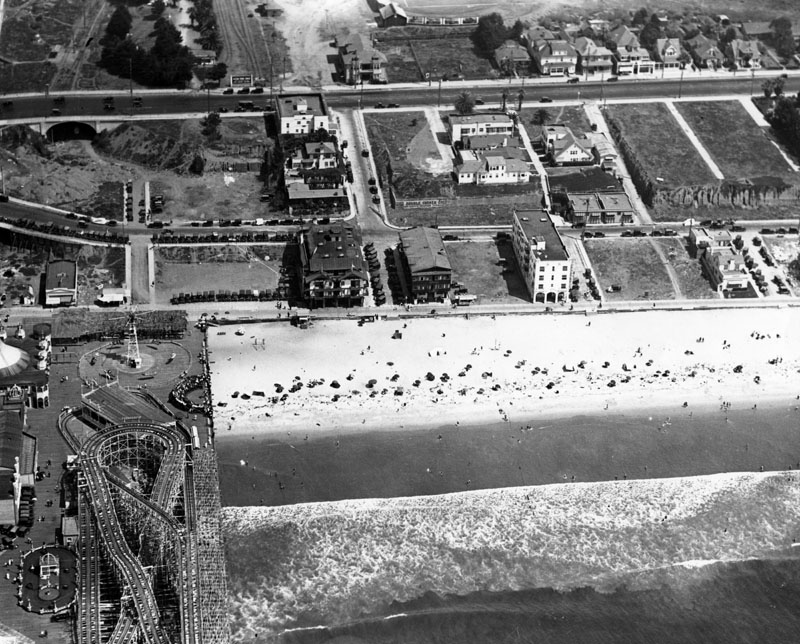
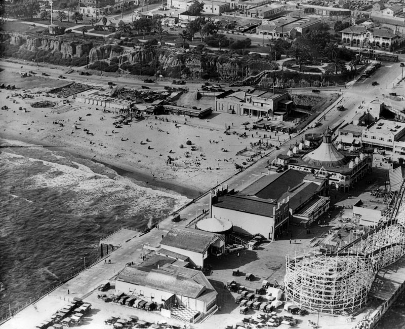
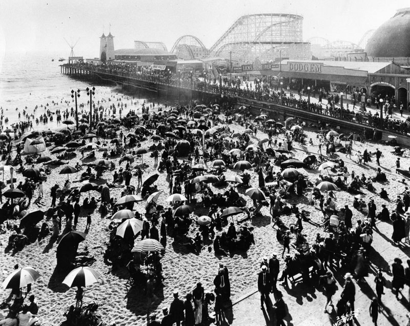
| (ca. 1920)* - Crowds enjoying a sunny day at the beach alongside Ocean Park Pier. The amusement park can be seen on the pier. |
Historical Notes The original Million Dollar Pier opened in 1911 but burned down just 15 months later in September 1912. It was quickly rebuilt and reopened as the Ocean Park Pier on May 30, 1913, becoming a popular regional attraction. In 1924, another devastating fire destroyed the pier, prompting new owners to rebuild it entirely out of reinforced concrete and steel as a fireproof structure. In 1925 Ocean Park Pier reopened. The new 960-foot long, 275-foot wide concrete Ocean Park Pier celebrated its grand opening on August 29, 1925 with a 10-day festival attended by 100,000 people on opening day. |
 |
|
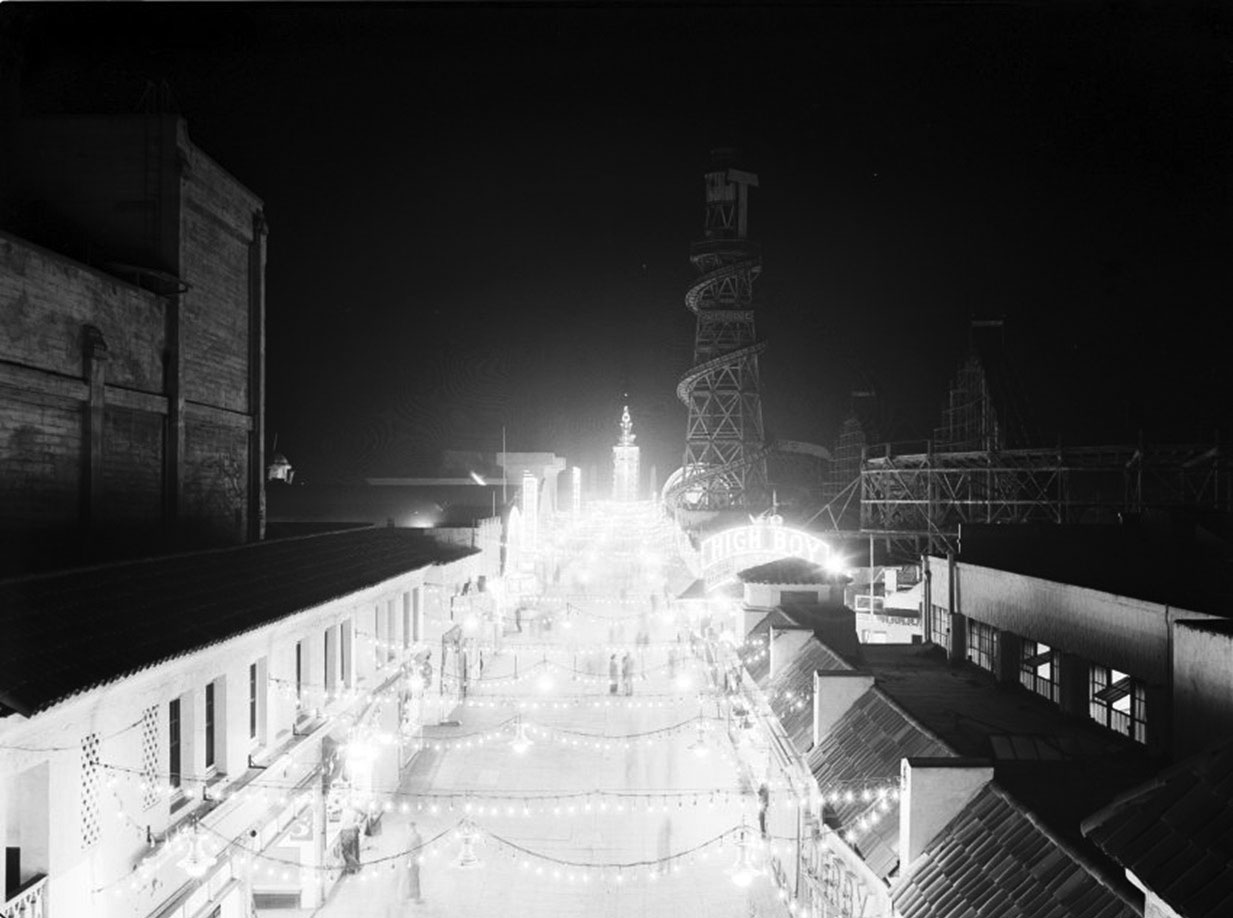
| (1924)* - Ocean Park Pier at night. |
 |
|
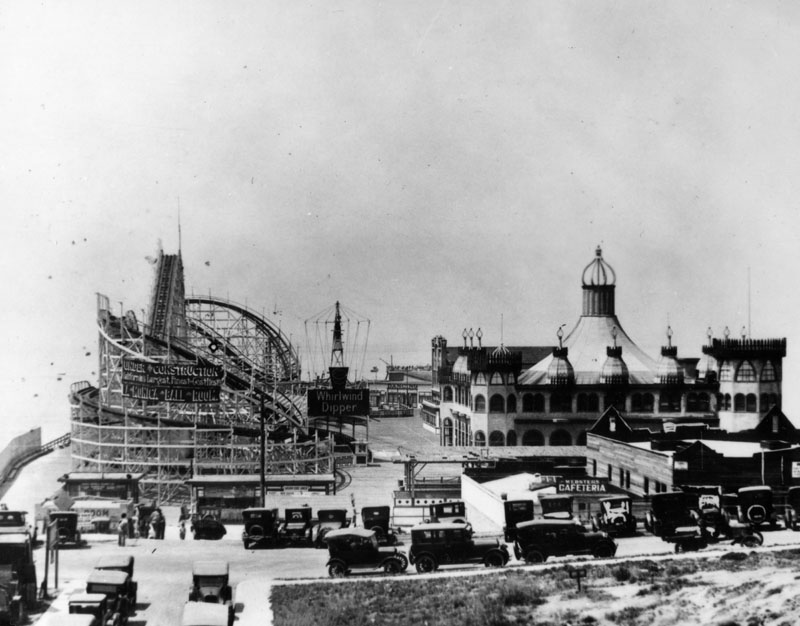
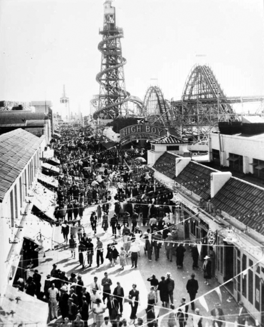
| (1929)* – View showing the Lighthouse Slide, High Boy roller coaster and Chute the chutes ride on the Ocean Park Pier at Ocean Park in Santa Monica. |
Historical Notes Click HERE to see more Early Views of Ocean Park and Other Santa Monica Amusement Parks. |
* * * * * |
Please Support Our CauseWater and Power Associates, Inc. is a non-profit, public service organization dedicated to preserving historical records and photos. Your generosity allows us to continue to disseminate knowledge of the rich and diverse multicultural history of the greater Los Angeles area; to serve as a resource of historical information; and to assist in the preservation of the city's historic records.
|
More Historical Early Views
Newest Additions
Early LA Buildings and City Views
History of Water and Electricity in Los Angeles
* * * * * |
References and Credits
* LA Public Library Image Archive
^^The California History Room, California State Library
^*LMU Digital Collection: Arcadia Hotel
#^ Santa Monica Public Library Image Archive
+# Santa Monica Mirror: Statue of Santa Monica
+^ Santa Monica Landmarks: Looff Hippodrome
## Library of Congress: Santa Monica Bay ca. 1908; Ferris Wheel
***Cinema Treasures: El Miro Theatre; Criterion Theatre and Thrid Street; Criterion Theatre
^x^Facebook.com: Venice, Ca, Ocean Park, & Santa Monica in the 20th Century
**^Noirish Los Angeles - forum.skyscraperpage.com; Deauville Club; Palisades Park Cannon
^^*Deviantart-Studio5: Santa Monica Beach
^^#University of California Digital Library: The Deauville Club
^^+Stanford University Revs Digital Library
*^#Nuestra Señora la Reina de los Ángeles: losangelespast.com
*#*KCET: A Historical Look at SoCal's Beaches
*#^Santa Monica Public Library
^#*Santa Monica History Museum
^#^Framework.latimes.com: Santa Monica Beach, 1936; Santa Monica Aerial, 1937; McClure Tunnel
^##The Malibu Times: Historic Las Flores Canyon
+##Facebook.com: Vintage Los Angeles
*#*KCET: A Historical Look at SoCal's Beaches; Arch Rock and Castle Rocks; When L.A.'s Most Famous Streets Were Dirt Roads
**#The Central Tower Building - City Landmark Assessment and Evaluation Report
#**MTA Transportation and Research Library Archives
#^^Huntington Digital Library Archive
#*^Electric Railway History: Venice Trams
#+#Facebook.com: Photos of Los Angeles
^^^California State Library Image Archive
****Life.time.com: Stoked-Life Goes Surfing
^^^^Pinterest/Santa Monica Past: Santa Monica Canyon Flood; Santa Monica Airport/Clover Field; Douglas Aircraft
*^*^Santa Monica Beach Stories
^**^California Legends: Santa Monica at the End of Route 66
*^^*Discoverlosangeles.com: Santa Monica
*^^^NonPhotography.com-Nika: Santa Monica Pier
***^History of the Fairmont Miramar Hotel and Bungalows
^***Southern California Beaches: Santa Monica Beach
**#*Santa Monica via Beverly Hills Line - uncanny.net
*#**Los Angeles Westerners Corral: Venice Miniature Railway
*##*AkamaIdivers.com: Pacific Ocean Pier
*##^Santa Monica Conservancy; Henshey’s Tegner Building
*#*#Los Angeles Then and Now: Douglas' Dream Took Wing in Santa Monica
*#^#Flickr.com: Walking Over Santa Monica
^#*#Venice History: Roller Coasters and Carousels
^^*#Oceanpark.wordpress.com: Ocean Park Time Line
*^*#Santa Monica Municipal Airport
*^^#LAistory: The Santa Monica Pier
#*^*Cardcow.com: Marion Davies' Mansion
#***California 2012 - Travel w/ Terry: Annenberg Beach House
#*#*Flickr.com: Michael Ryerson
#^#*Denver Public Library Image Archive
#^^^Survey LA: Brentwod-Pacific Palisades Community Plan Area
#^*^Santa Monica Landmark Properties
#^^*Pinterest.com: Old Hollywood
#^#^Paslisades Park: smgov.net
##*^Facebook.com: Hollywood's Garden of Allah Novels, Martin Turnbull
##^^MartinTurnbull.com: Gables Beach Club
****^Facebook.com: West San Fernando Valley Then And Now
^*^*^Wehadfacesthen.tumblr.com
*^*^*SantaMonicaPier.com
*#*#*Venice Miniature Railroad - Jeffrey Stanton
*^ Wikipedia: California State Route 1; History of Santa Monica; Alphonzo Bell; Venice; California Incline; Route 66; Third Street Pomenade; Santa Monica Pier; Casa del Mar Hotel; Pacific Palisades - Castellammare; Parkhurst Building; Venice Canal HIstoric District; Annenberg Community Beach House; Santa Monica High School; Jack Dempsey; Muscle Beach; Wilshire Boulevard
< Back