Early Views of Pasadena
| Historical Photos of Early Pasadena |
 |
|
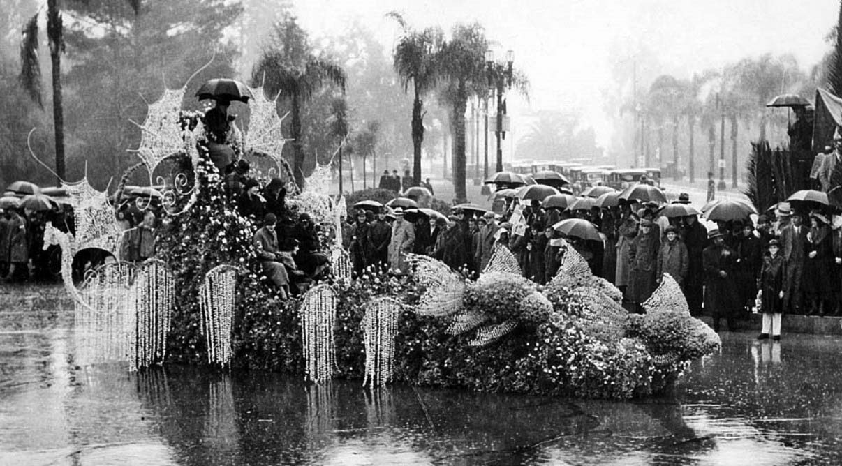
| (1934)* – Don't Rain on My Parade! Tournament Roses queen Treva Scott, top of float with umbrella, and her court during a rainstorm. |
Historical Notes It has rained ten times on the Rose Parade, but the parade has never been canceled due to weather. Those rainy years were 1895, 1899, 1906, 1910, 1916, 1922, 1934, 1937, 1955, and 2006. |
 |
|
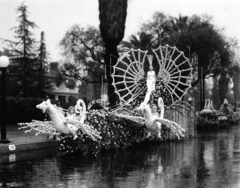
| (1934)* - A Los Angeles Chamber of Commerce float in the 1934 Tournament of Roses Parade. The street is wet. |
Rose Bowl
 |
|
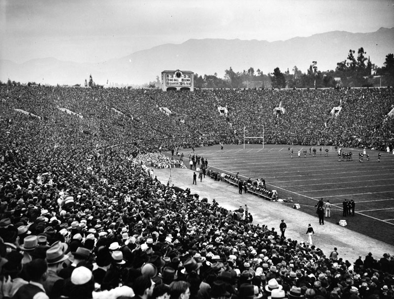
| (1939)* - View of a football game, played in front of a packed stadium at the Rose Bowl in Pasadena. Photo dated: June 22, 1939. |
Arroyo Seco Parkway (later Pasadena Freeway)
 |
||
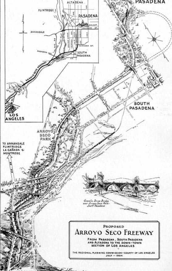
| (1934)^+^ - Map showing the proposed Arroyo Seco Freeway/Parkway from Pasadena, South Pasadena and Altadena to the Downtown section of Los Angeles. |
Historical Notes Built during the Great Depression, construction of the Arroyo Seco Parkway put a lot of people to work. At the time, it was considered an engineering marvel, reducing travel time between Los Angeles and Pasadena from 27 to 12 minutes. |
 |
|
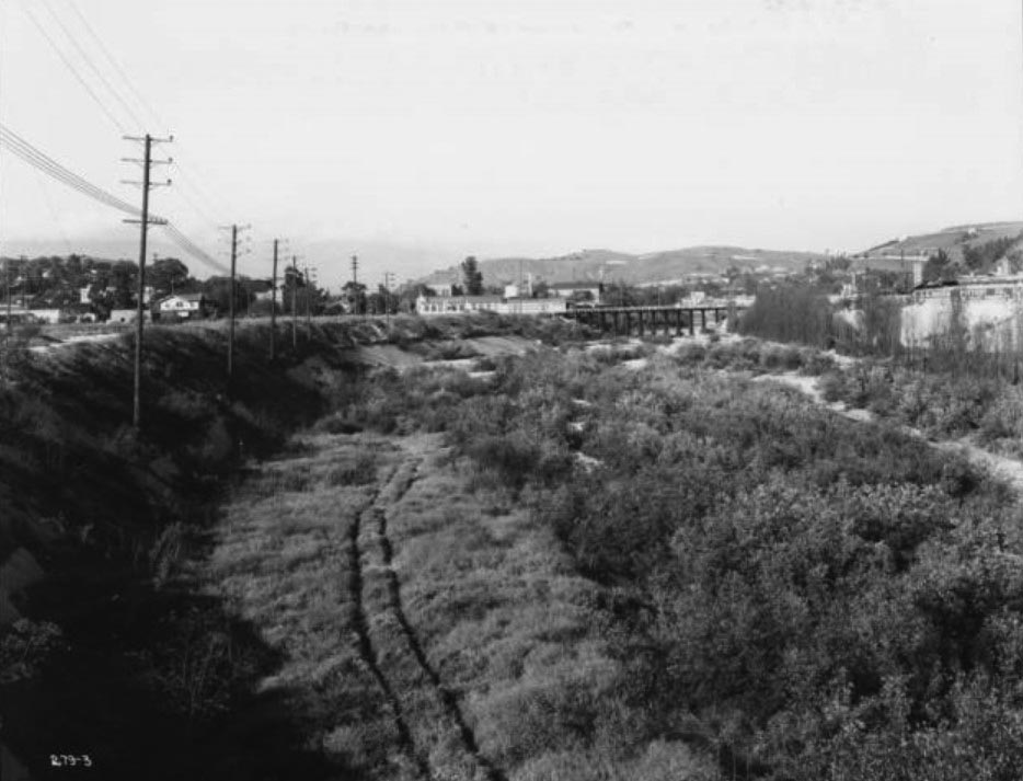
| (1936)*^* - View of the proposed Arroyo Seco Parkway location looking upstream from Avenue 26, toward Pasadena. The bridge in the center of the picture is the Cypress Avenue Bridge of the Union Pacific Railroad. The route of the proposed parkway follows along the left side of the wheel tracks in the foreground. The Sunshine Laundry Building can be seen next to the bridge. |
Historical Notes Before the Parkway was built, cottonwoods filled the Arroyo Seco at Avenue 26. The first known survey for a permanent roadway through the Arroyo was made by T.D. Allen of Pasadena in 1895, and in 1897 two more proposals were made, one for a scenic parkway and the other for a commuter cycleway.*^ |
 |
|
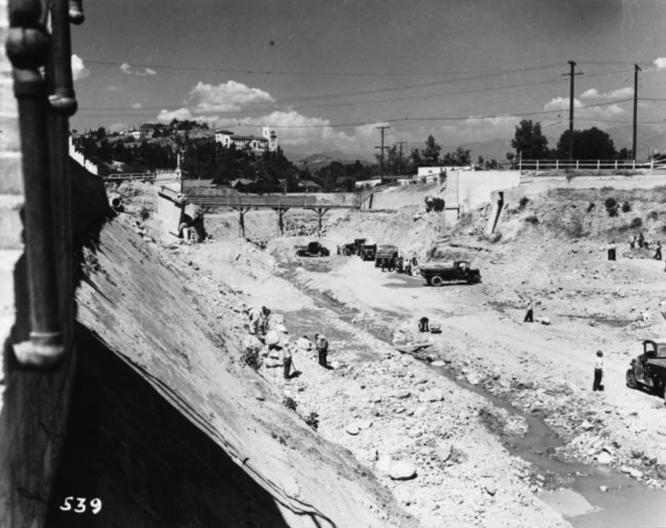
| (1938)*^* - Looking northeasterly showing the construction of the Arroyo Seco Parkway, with the demolition of old Avenue 43 Bridge in progress. The Southwest Museum is on the hill in the background. |
 |
|
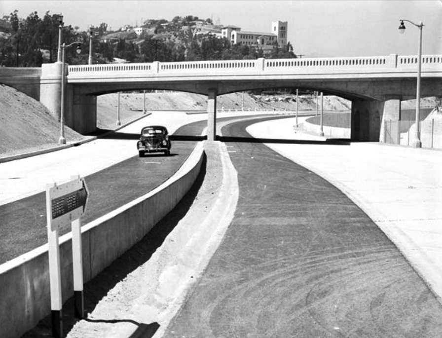
| (1940)*#* – View showing the Arroyo Seco Parkway shortly after its completion with the Southwest Museum in the background. |
Historical Notes The Arroyo Seco Parkway was the first freeway in California and the western United States, connecting Los Angeles with Pasadena alongside the Arroyo Seco seasonal river. It is notable not only for being the first, mostly opened in 1940, but for representing the transitional phase between early parkways and modern freeways. It conformed to modern standards when it was built, but is now regarded as a narrow, outdated roadway.*^ |
 |
|
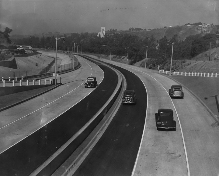
| (1940)* - Caption reads, "First motorists to travel over the new link are pictured at the Avenue 53 bridge. The freeway is divided in the center by a small parkway. Each side has three wide lanes for traffic. The new part runs from Avenue 40 to Orange Grove drive. The Glenarm-Fair Oaks section has been open some time." Photograph dated: July 20, 1940. The Southwest Museum can be seen in the distance. |
Historical Notes The Arroyo Seco Parkway was designed with two 11–12 foot lanes and one ten-foot shoulder in each direction, with the wider inside (passing) lanes paved in black asphalt concrete and the outside lanes paved in gray Portland cement concrete.*^ |
 |
|
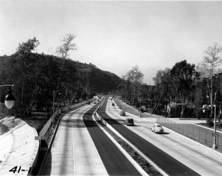
| (1941)^ - The Arroyo Seco Parkway shortly after it was completed. View is looking south from Avenue 60. Note the exit on the right is virtually a perpendicular right turn without an off-ramp or transition. |
Historical Notes At the time, it was considered an engineering marvel, reducing travel time between Los Angeles and Pasadena from 27 to 12 minutes. |
 |
|
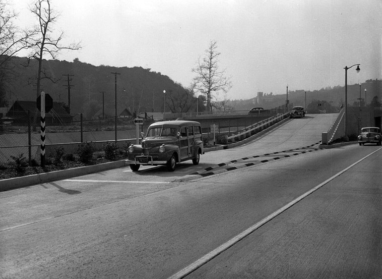
| (1942)^ - View of a 1941 Ford Woody, with the bumper-guard and dual spotlights options, waiting at the stop sign before proceeding unto the Arroyo Seco Parkway. |
Avenue 52 southbound onramp.
Historical Notes The Arroyo Seco Parkway design, state-of-the-art when built, included tight "right-in/right-out" access with a recommended exit speed of 5 miles per hour and stop signs on the entrance ramps; there are no acceleration or deceleration lanes.*^ |
 |
|
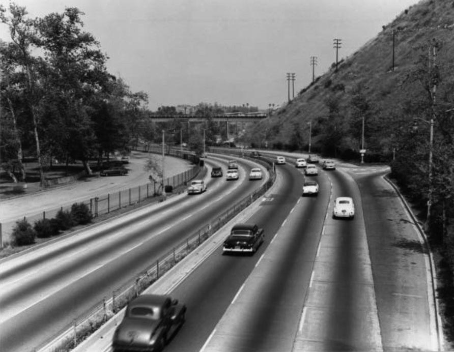
| (1949)* - View is of the Arroyo Seco Parkway, looking south from Bishops Road Bridge. The freeway is divided in the center by a small parkway. Each side has four wide lanes for traffic - though the southbound portion is not visible due to the parkway |
Historical Notes Today, the Arroyo Seco Parkway remains the most direct route between downtown Los Angeles and Pasadena despite its flaws; the only reasonable freeway alternate (which trucks must use) is the Glendale Freeway to the west, which is itself not easily reached by trucks from downtown Los Angeles. The state legislature designated the original section, north of the Figueroa Street Viaduct, as a "California Historic Parkway" (part of the State Scenic Highway System reserved for freeways built before 1945) in 1993. The American Society of Civil Engineers named it a National Civil Engineering Landmark in 1999, and it became a National Scenic Byway in 2002 and was added to the National Register of Historic Places in 2011.*^ |
 |
|
| (1955)*^* – View looking north at the Arroyo Seco Parkway from the Avenue 60 Bridge. |
Historical Notes When built in the 1930s the Arroyo Seco Parkway conformed to modern standards of the times (including a speed limit of 45 mph), but is now considered by many as too narrow and dangerous for the amount of vehicular traffic it serves on a daily basis. The six-lane, six-mile long highway was designed for 27,000 automobiles a day. These days, it carries more than 122,000 cars daily.**# |
 |
|
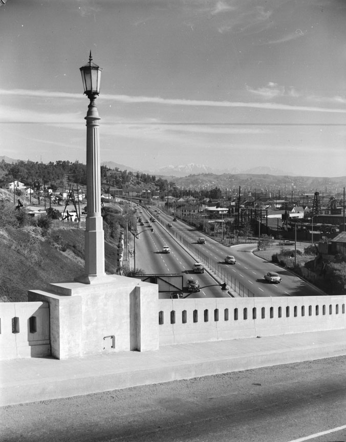
| (1955)^ - View looking north at Arroyo Seco Parkway (Pasadena Freeway) from College St. Bridge. In the distance can be seen the snow-capped San Gabriel Mountains. |
 |
|
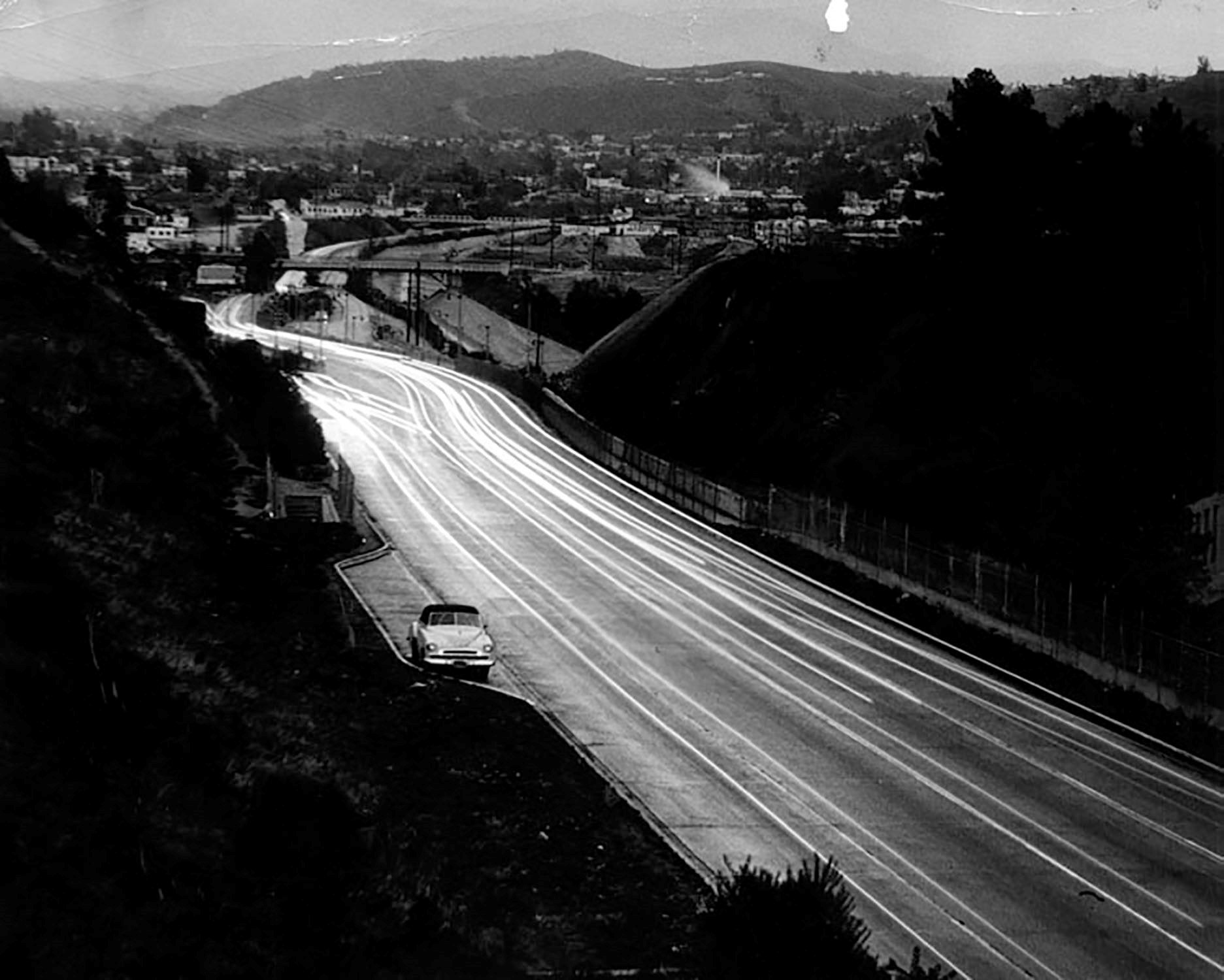
| (1948)* – Night view looking north on the 110 (Arroyo Seco Parkway) on a rainy day, with one car pulled over in the turnout. |
 |
|
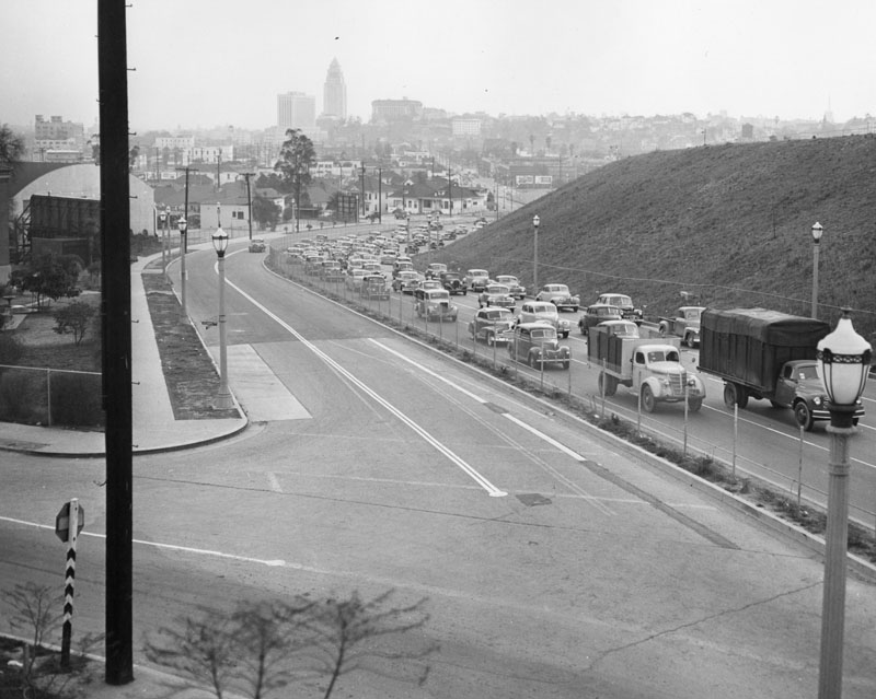
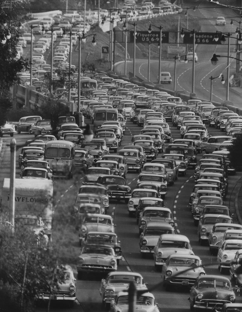
| (1950s)* – View showing densely packed traffic travelling southbound on the Pasadena Freeway, from Park Row Drive overlooking the Freeway near Civic Center. |
Historical Notes Between 1954 and 2010, Arroyo Seco Parkway was officially designated the Pasadena Freeway. In 2010, as part of plans to revitalize its scenic value and improve safety, Caltrans renamed the roadway back to its original name. All the bridges built during parkway construction remain, as do four older bridges that crossed the Arroyo Seco before the 1930s. |
* * * * * |
 |
|
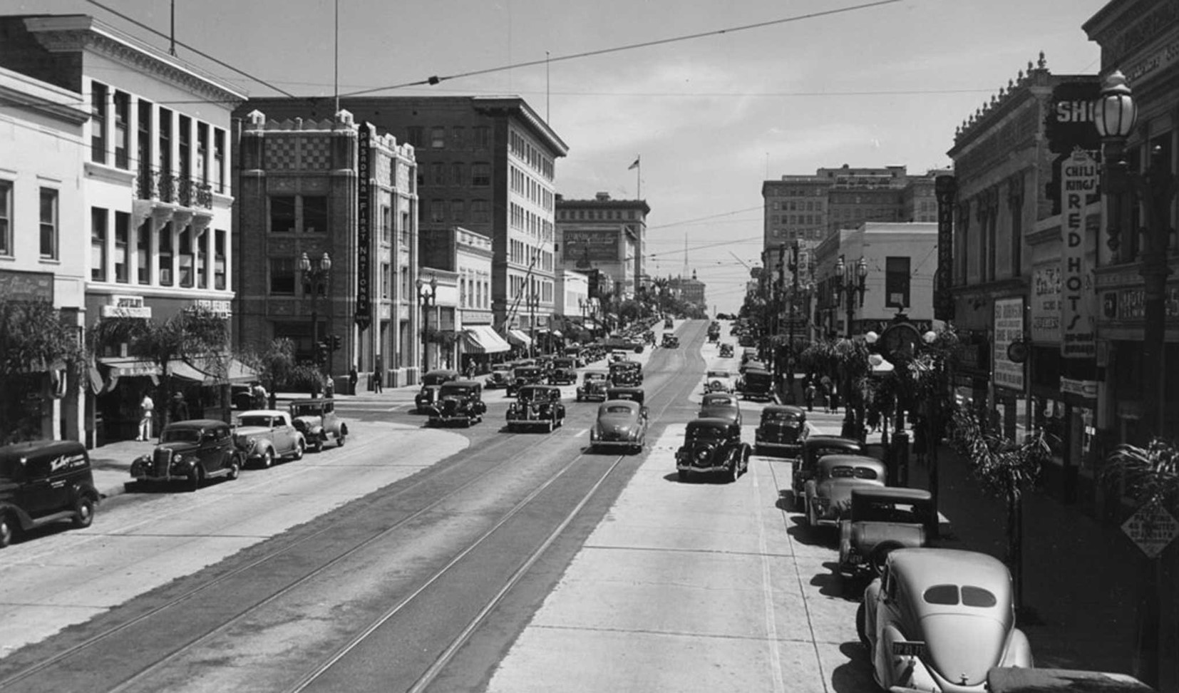
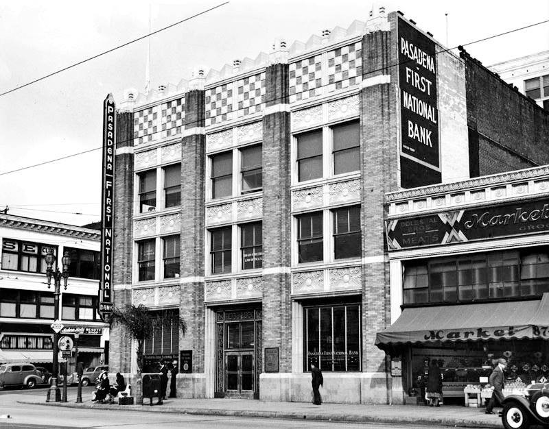
| (ca. 1940)* – Looking east on Colorado Boulevard towards Raymond where Pasadena First National Bank stands on the NE corner. |
Pasadena First National Bank
 |
|
| (1938)++# - Pedestrians stroll down the sidewalk in front of the Pasadena First National Bank building, on the northeast corner of Colorado and Raymond. The city has done an excellent job preserving parts of Old Pasadena: the view today is remarkably similar. |
Then and Now
 |
|
 |
|
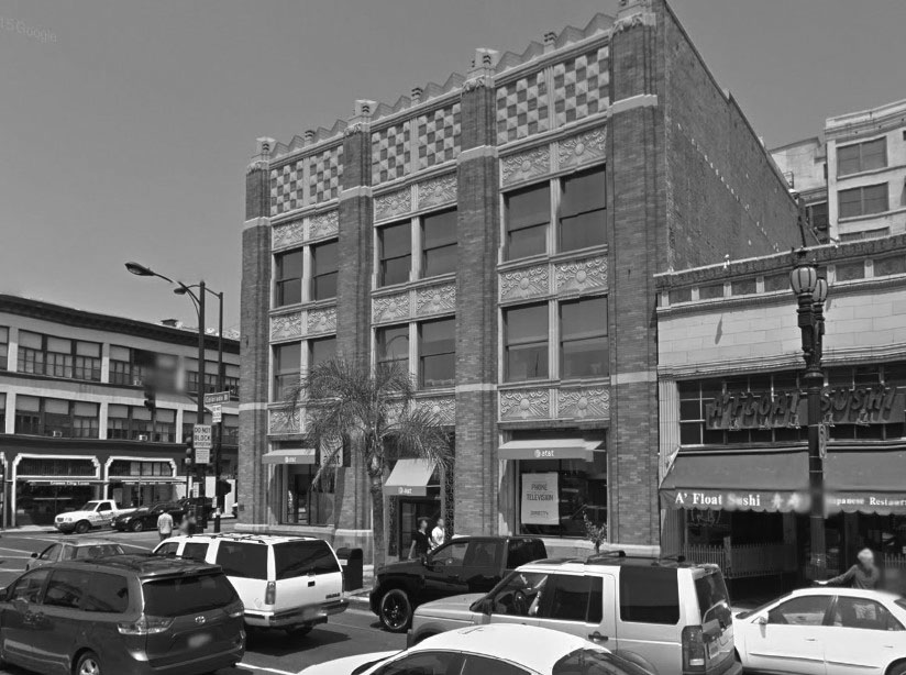
| (1938)++# vs. (2015)## - Building on the northeast corner of Raymond Ave and Colorado Boulevard, now occupied by an AT&T store. |
Fair Oaks and Green Street
 |
|
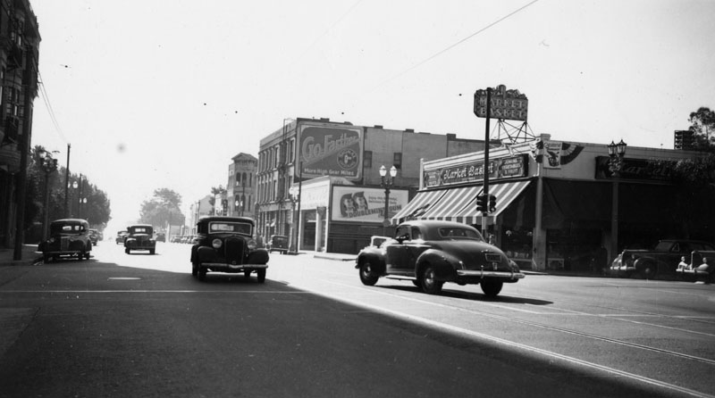
| (1941)* - View of 105 So. Fair Oaks Avenue at Green Street in Pasadena on December 24, 1941, site of a Market Basket grocery store. |
Historical Notes The three story building with the "Go Farther" billboard, once housed the John Bull pub in the 70s & 80s.^*^# |
Then and Now
 |
|
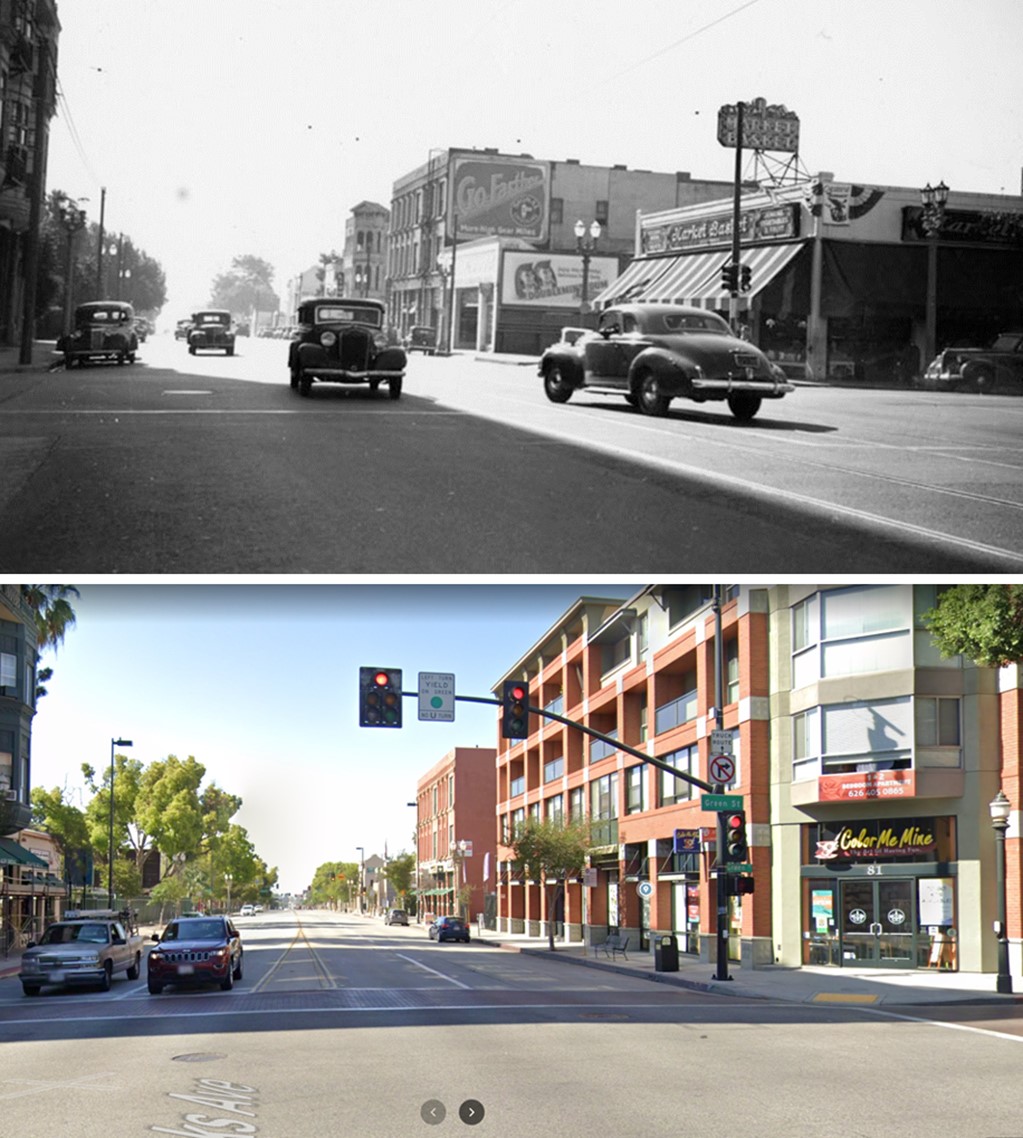
| (1941 vs. 2022)* - Looking south on Fair Oaks Avenue at Green Street. A Market Basket is seeen on the SW corner, today the site of mixed-use housing. |
 |
|
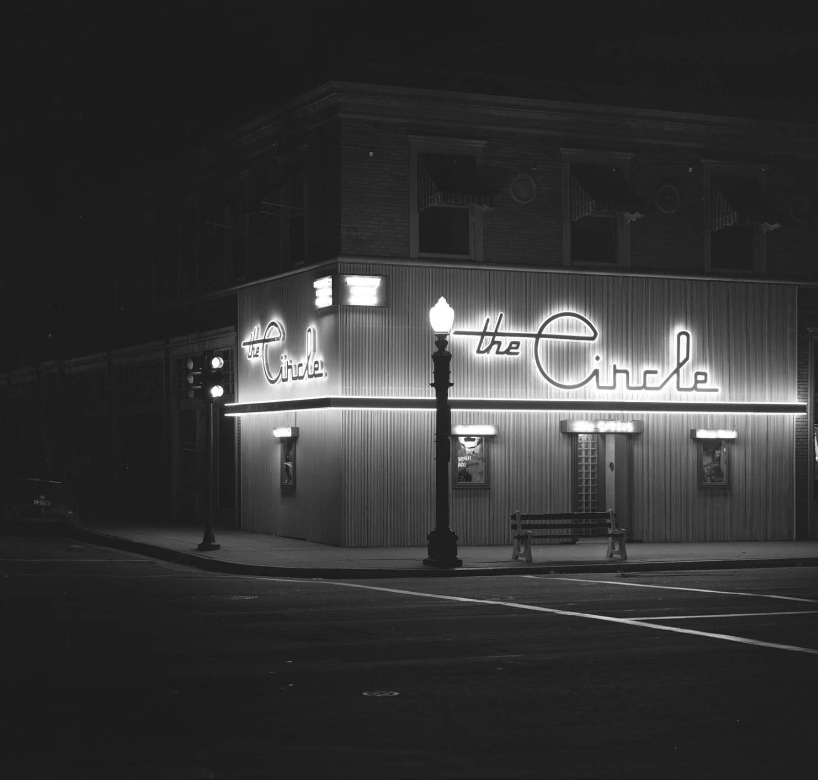
| (1946)*^* – View showing the Circle Café located at 953 East Colorado Boulevard, NE corner of Colorado and Mentor Ave. Photo by J. Allen Hawkins. Today, an H&R Block occupies the ground floor. Click HERE for contemporary view. |
 |
|
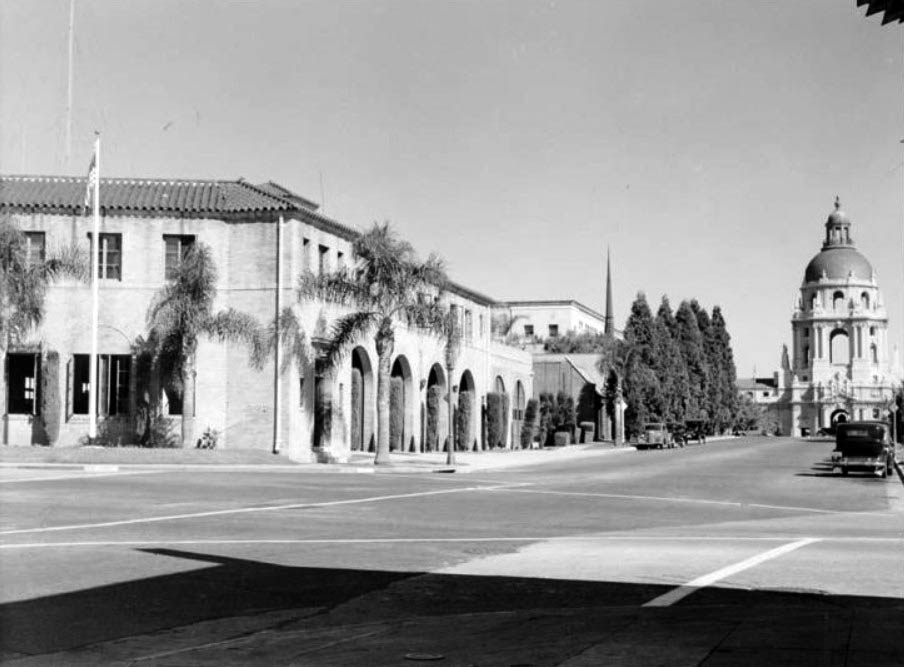
| (1939)*^* - View of the Old Fire Station 1 at corner of Holly and Arroyo Parkway looking eastward toward city hall. Arroyo Parkway here used to be N. Broadway. |
 |
|
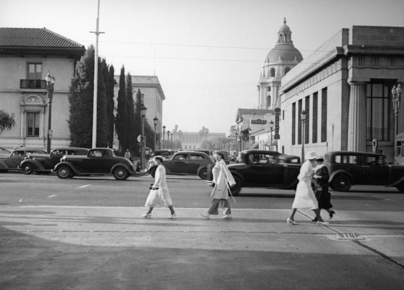
| (ca. 1940s)* - Pedestrians and cars on Colorado Blvd. in Pasadena circa the 1940s. View is looking north toward City Hall on Garfield Avenue. |
 |
|
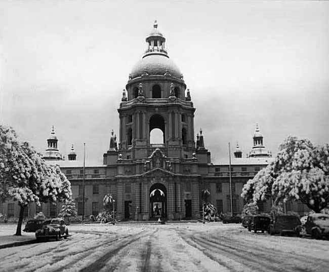
| (1949)++# – Pasadena City Hall in snow, January 1949. |
 |
|
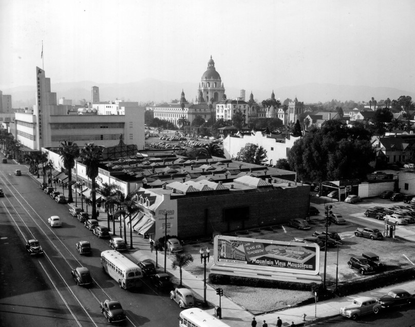
| (1945)^#^# - View from above the corner of Colorado Boulevard and Oakland Avenue as seen from the Independent-Star News building. The Broadway Pasadena is on the left and City Hall at top center. |
The Broadway Pasadena
 |
|
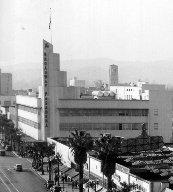
| (1945)^#^# – Close-up view of the Art Deco Broadway Pasadena on Colorado Boulevard. |
Historical Notes The Broadway began branch expansion in earnest with a striking art-deco store on Pasadena’s Colorado Boulevard. A similar store anchored the Baldwin Hills Crenshaw Plaza in 1947. With the help of its architects, The Broadway developed a signature look for its suburban stores, which numbered in the thirties by 1979. #*** |
 |
|
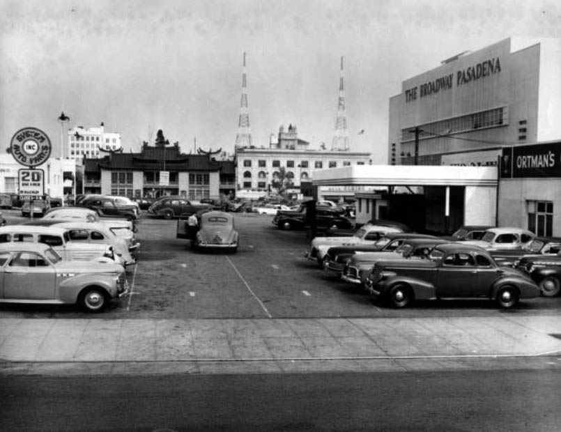
| (ca. 1945)*^* - View showing the parking lot of The Broadway department store in Pasadena. In the background can be seen the Grace Nicholson Building (now the Pacific Asia Museum) located on N. Los Robles. |
Bullock's Pasadena
 |
|
| (1947)* – Postcard view showing the newly completed Bullock's Department Store in Pasadena. |
Historical Notes Built in 1947, the Streamline Moderne Art Deco building was designed by noted Los Angeles architects Wurdeman & Becket, a partnership between Welton Becket and Walter Wurdemen. In addition to the building itself, the architects oversaw the design and installation of all aspects of the store's interior, from the wallpaper and display cases, to the unique mechanical conveyor system that delivered purchases directly to the parking lot. The design and merchandising of store were unique and stood in contrast to many older department stores of the time. Bullock's Pasadena was among the first department stores in the country to be located outside of a downtown area and was intended to appeal to the emerging "carriage trade," or those shoppers arriving by automobiles. As such, the store was oriented toward an unheard of 6-acre parking lot located behind the structure. The store's promoters touted it as the "store of tomorrow" and Arts and Architecture magazine described it as "one of the world's most modern buildings." In fact, the design was recipient of an AIA Merit Award in 1950. |
 |
|
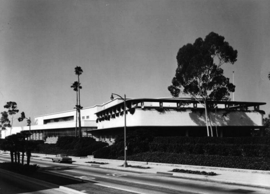
| (1960s)* - View showing the Bullock's Department Store located at 401 S. Lake Avenue in Pasadena. |
Historical Notes To attract the garden-loving populace of Pasadena and the San Gabriel Valley, landscape architect Ruth Shellhorn worked with Wurdeman and Becket to create a lush landscape from which the massive building arose like an island. In a then-astonishing concession to the automobile, Bullock's Pasadena prefigured mid-century commercial development throughout Los Angeles by featuring a rear six-acre parking lot. The parking lot has since been developed into a new retail center by Johnson Favaro (2003). The South Lake Avenue shopping district, in which Bullock's Pasadena was a major player, started to lose its luster in the late 1980s. While Pasadena's once-seedy Old Town district was reborn as a trendy shopping and entertainment district, once-proud South Lake Avenue lost much of its distinction. On July 12, 1996, the building was listed in the National Register of Historic Places as No. 96000776. In May 2000, the city of Pasadena's Design Review Board granted approval for a redevelopment of the building as part of a new shopping area called "The Shops on Lake Avenue," a $33 million project, featuring specialty shops, 27,000 square feet of new restaurants and a new 300-space-parking garage, increasing parking capacity to nearly 1,200 spaces. Developed by Cleveland, Ohio-based Forest City Development California, Inc. and owned by Federated Department Stores, the project opened in the spring of 200. |
* * * * * |
Richfield Gas Station
 |
|
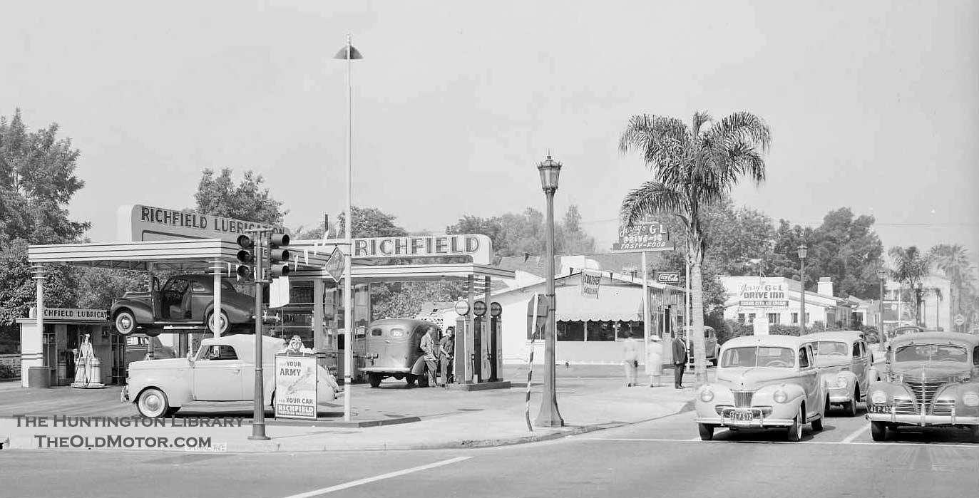
| (1941)* - A Richfield Gas Station located on the SW corner of Lake Ave and E. Green St (East California Blvd?). See notes below. |
Historical Notes Members of the Facebook group ‘You Know You Are from Old School Pasadena…’ disagree with the original location stated in the Huntington Library source. The majority opinion is that the station was actually located at Lake Ave and Green Street. Despite some conflicting evidence, we lean towards Green Street as the correct location instead of California Street. More details to come. |
 |
|
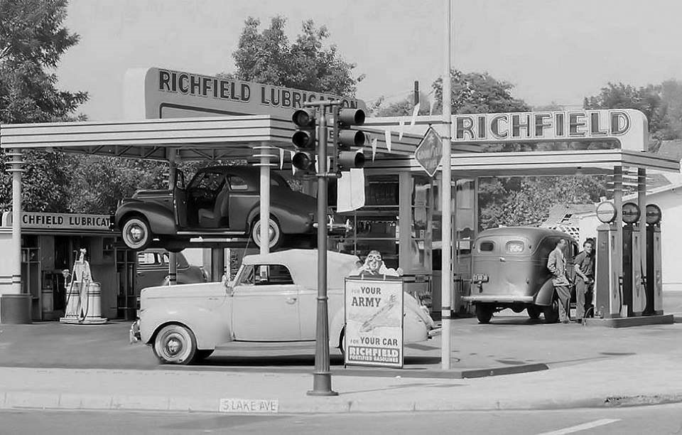
| (1941)^ – Close-up view showing the Richfield Gas Station on S. Lake Ave in Pasadena. Sign on corner reads: “For Your Army and For Your Car – Richfield" |
* * * * * |
Union 76 Service Station
 |
|
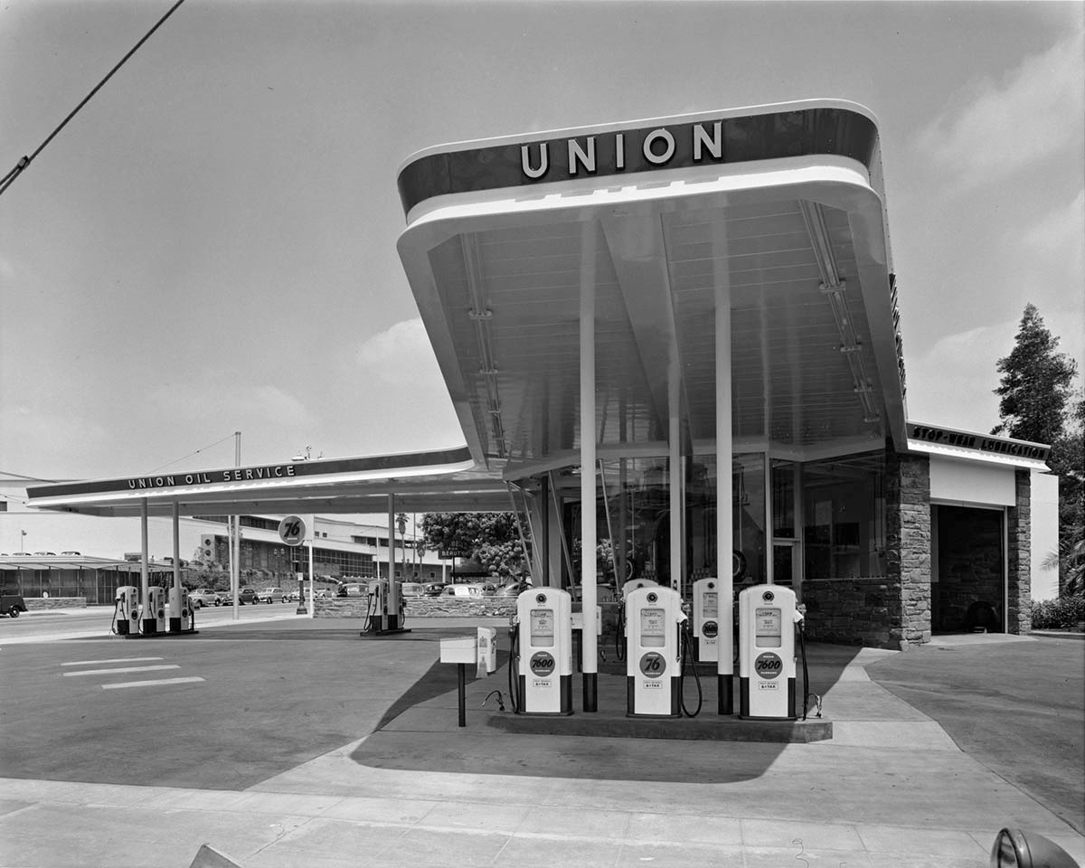
| (1949)* – View showing Union 76 Service Station located on the corner of San Pasqual Street and S. Lake Avenue in Pasadena. Bullock’s Department Store is seen in the background on the left. The building was designed by architect Raymond Loewy. Photo by Julius Shulman / Getty Research Institute |
Click HERE to see more Early Views of Gas Stations |
Guinn’s Coffee Shop and Drive-in
 |
|
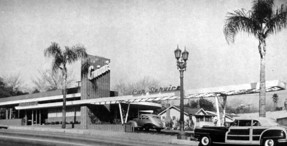
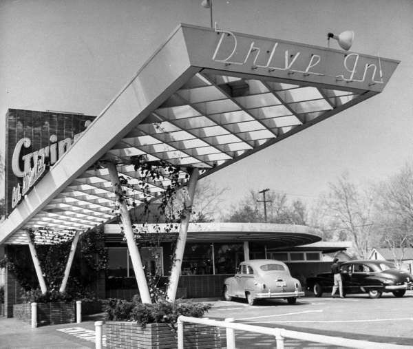
| (1940s)^^+ – View showing Guinn’s Coffee Shop and Drive-in located at 2915 E. Colorado Boulevard, Pasadena. |
Historical Notes Gwinn’s Drive-in was designed by Harold J. Bissner and Harold B. Zook. |
 |
|
| (ca. 1947)**## – Gwinn’s Coffee Shop and Drive-in, 2915 E. Colorado Blvd. (U. S. 66) Pasadena. |
Historical Notes Guinn's Drive-in was demolished around 1992. |
Click HERE to see more Early Drive-in Restaurants |
* * * * * |
 |
|
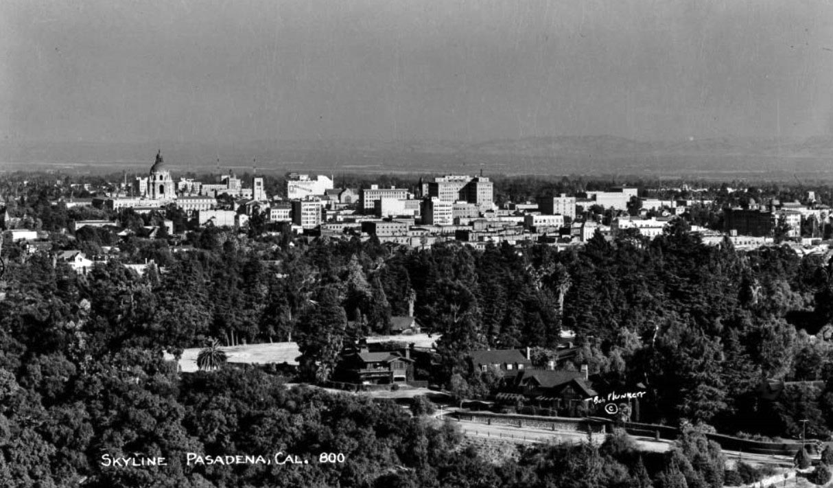
| (ca. 1948)* – Panoramic view showing the Pasadena skyline in the city center. The tall dome of Pasadena City Hall is seen at left. |
 |
|
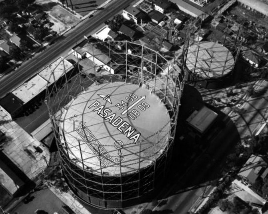
| (1948)* – Aerial view showing gas collection towers located along Edmonson Alley, between Fair Oaks and Raymond, just north of Glenarm Street. |
Historical Notes The larger of the two gas towers provided gas for the entire city of Pasadena. There are words, numbers and symbols on the roof of the larger tank providing directions and information for pilots flying overhead. The arrow reading "Grand Central" refers to the Burbank Airport. |
 |
|
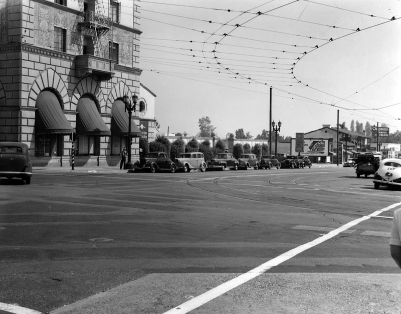
| (1947)* - View south on Lake Ave. from Colorado Blvd. in Pasadena. The building on the left corner is the Security-First National Bank of Los Angeles, next to it is a parking lot, and in the background, on the right, is Chapman's Famous Ice Cream shop. Several cars can be seen parked along the right side of the street. |
 |
|
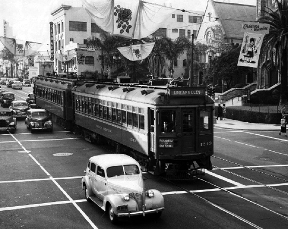
| (1949)*** - Pacific Electric Railway cars 1243 and 1211 head eastbound on Colorado Boulevard at Oakland Avenue beneath banners for the 1949 Tournament of Roses Parade. |
Historical Notes The Pacific Electric Railway route consisted of travelling on Colorado Boulevard to Lake Avenue, then south to merge onto Oak Knoll where it ran further south to Huntington Drive and then west, on its way to the PE building at 6th and Main Streets in Los Angeles. |
 |
|
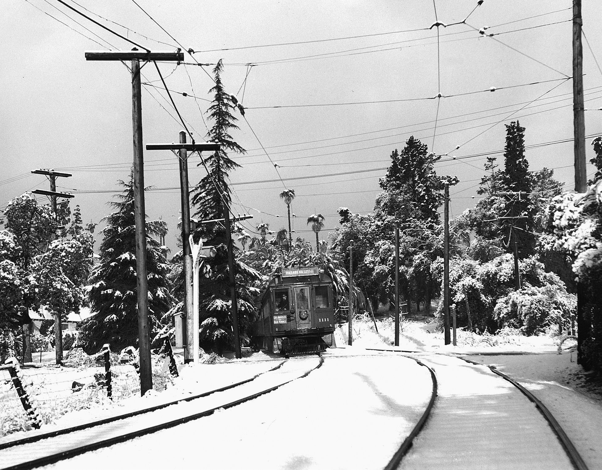
| (1949)^*# – Climate change on the Pasadena line. View showing the Oak Knoll Line at Old Mill Road in San Marino on January 11, 1949. |
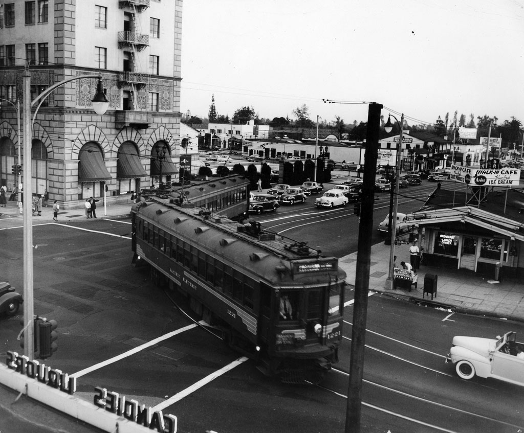
Historical Notes Pasadena via Oak Knoll was a line of the Pacific Electric Railway, running from 1906 until 1950, between Downtown Los Angeles and Downtown Pasadena, with additional service to Altadena during rush hour. The route was originally built in 1906 to reach the Wentworth Hotel (later Huntington Hotel) in Oak Knoll. It was the second to last PE line to be decommissioned in Pasadena, and was the last line to run along Colorado Boulevard. |
 |
|
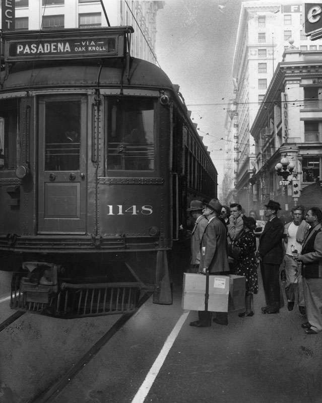
| (1950)* - A crowd of passengers wait to board the Pacific Electric Red Car No. 1148 at 6th and Main, going to Pasadena via Oak Knoll. A man carries a large package labeled "rush" and "fragile". |
Historical Notes The Red Car trolley line to Pasadena made its last run in 1950. The caption for the Oct. 3, 1950 photo read: "Its days are numbered. After Sunday, no more P.E. Oak Knoll Red Cars will rumble from Sixth and Main (above) to Pasadena". |
 |
|
| (1950)*^^ - A Pacific Electric street car turns onto Colorado from Lake, on the last day of the line’s operation in Pasadena, October 7, 1950. |
 |
|
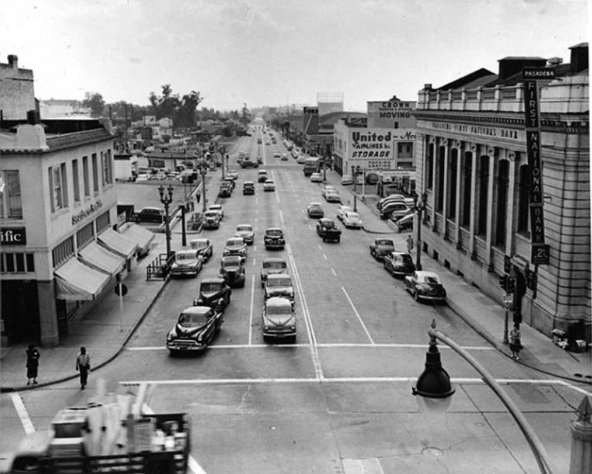
| (ca. 1950)* – View looking south on Arroyo Parkway at Colorado Boulevard. The Pasadena First National Bank stands on the southwest corner, while the Pacific Electric ticket office occupies the building on the opposite corner at left. In the distance at right is the Pasadena Winter Garden. |
Santa Fe 'Chief'
 |
|
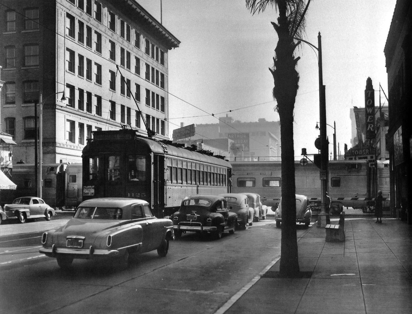
| (ca. 1950)* – View looking east on Colorado Boulevard from just west of the Santa Fe crossing in Pasadena. PE Interurban 1125 is inbound to LA by way of the Oak Knoll line but is held up by the Chief passing in front. Note also the Tower Theater at right. Photo by Stan Kistler. Click HERE to see contemporary view. |
Historical Notes The Chief was one of the named passenger trains of the Atchison, Topeka and Santa Fe Railway. Its route ran from Chicago, Illinois to Los Angeles. The Chief was inaugurated as an all-Pullman limited train to supplement the road's California Limited, with a surcharge of $10.00 for an end-to-end trip. The heavyweight began its first run from both ends of the line, simultaneously, on November 14, 1926, scheduled 63 hours each way between Chicago and Los Angeles, five hours faster than the California Limited. |
 |
|
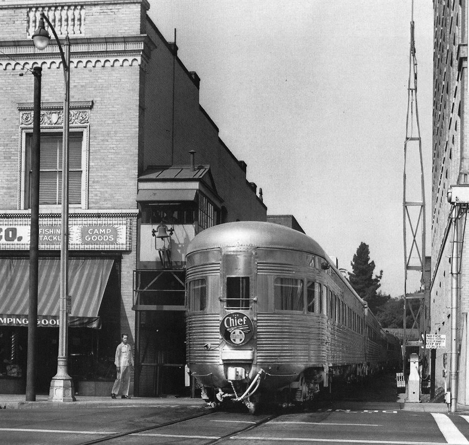
| (ca. 1950)* - View looking north at the Colorado Boulevard Santa Fe crossing. The all-Pullman Chief, outbound to Chicago, is at center. Note the elevated flagman shanty, complete with warning bell, at center left. Photo by Donald Duke. Click HERE to see contemporary view. |
Historical Notes The Chief became famous as a "rolling boudoir" for film stars and Hollywood executives. In 1954 the Chief reduced its schedule to equal its cousins, the Super Chief and El Capitan, and would ultimately drop the extra fare requirement as well. |
 |
|
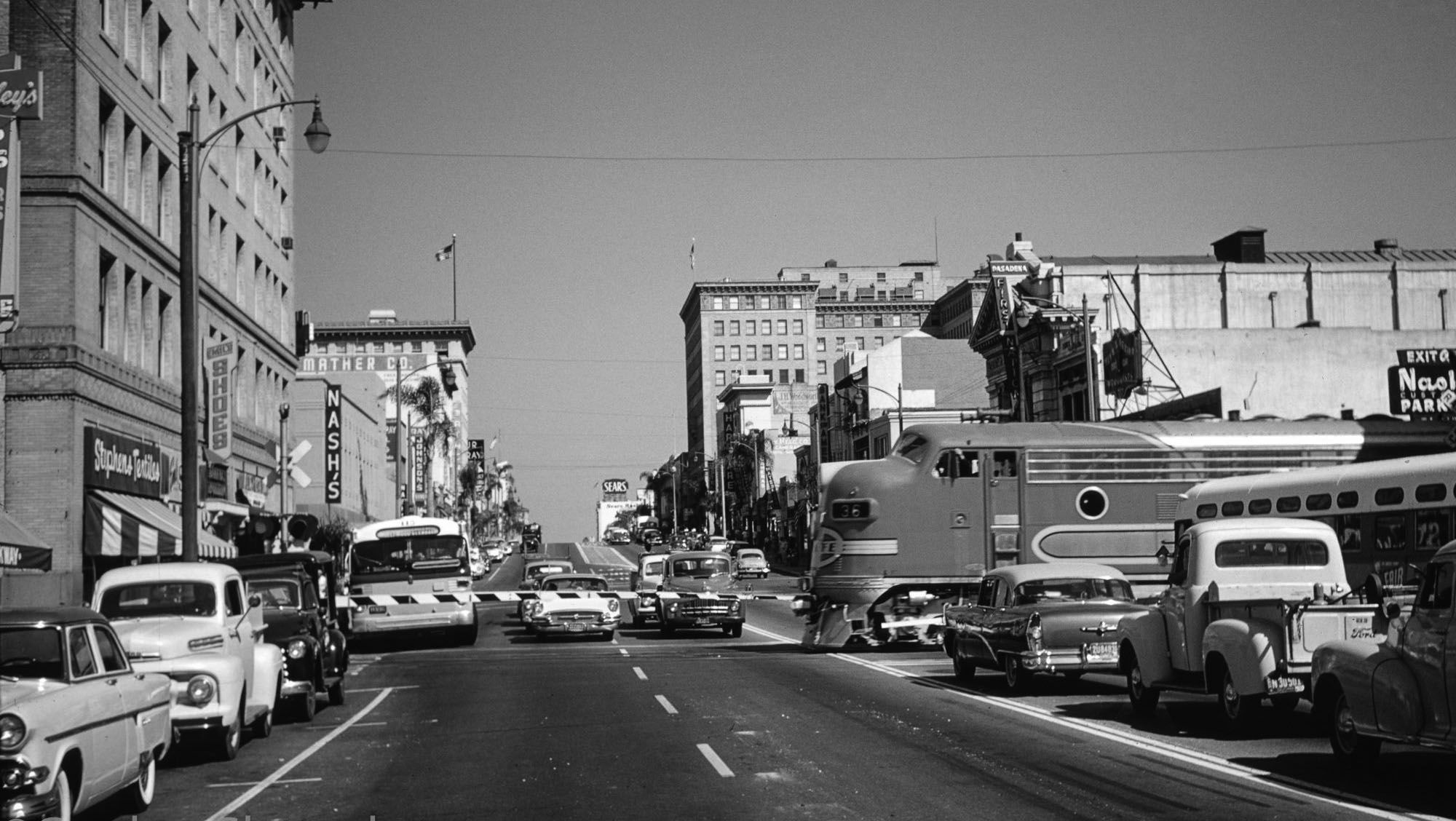
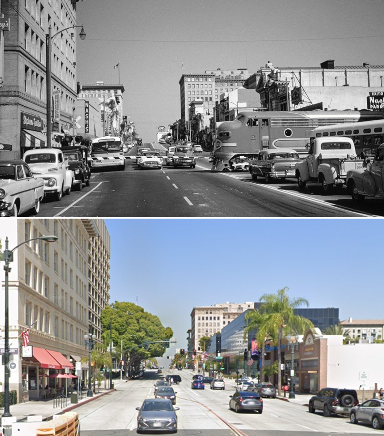
| (1958)^ - Santa Fe and Route 66 in Pasadena. The eastbound Chief noses past midcentury traffic on Colorado Boulevard; Metro's Gold Line now burrows underneath. Photo: Gordon Gattenberg / Los Angeles Heritage Railroad Foundation |
Historical Notes The Chief would have been the "crown jewel" of most railroads' passenger fleets. But it did not survive the national decline in passenger demand and its last run was on May 15, 1968. |
 |
|
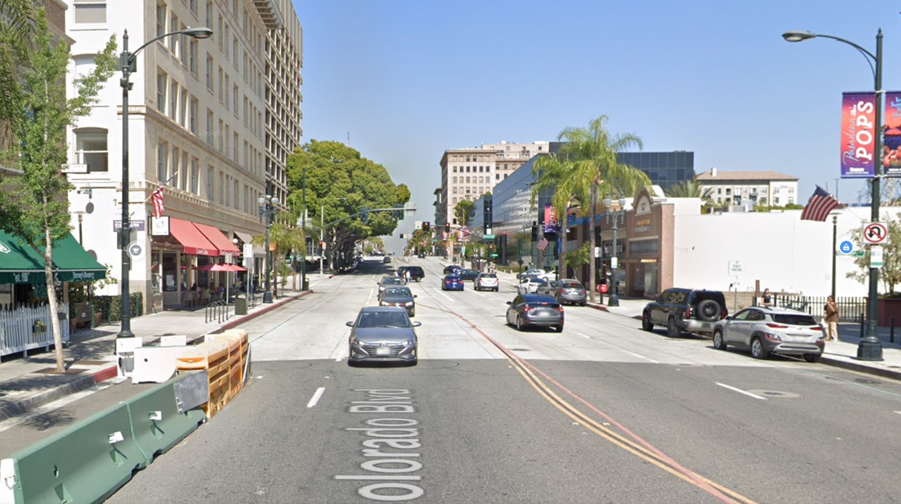
| (2022)* – Looking east on Colorado Boulevard (Route 66) between Raymond Ave and Arroyo Pkwy in Pasadena where the Santa Fe ‘Chief’ once crossed the iconic boulevard. Metro's Gold* Line now burrows underneath. |
Historical Notes * It is no longer referred to as the Gold Line as it is now combined with the former Blue Line as originally planned and is now known as the A Line between Azusa (and soon Pomona) and Long Beach. |
Then and Now
 |
|
| (1958 vs 2022)* – Looking east on Colorado Boulevard (Route 66) between Raymond Ave and Arroyo Pkwy in Pasadena where the Santa Fe ‘Chief’ once crossed the iconic boulevard. Metro's Gold Line now burrows underneath. Original Santa Fe Railway Photograph by Gordon Glattenberg |
* * * * * |
 |
|
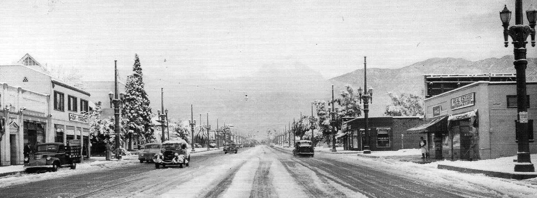
| (1949)^ - View looking north on Lake Ave after a snow storm. Photo date: 1/10/49. |
 |
|
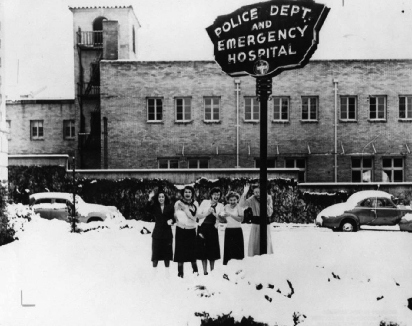
| (1949)* - Five women are waving and smiling, standing in the snow under a sign that reads, "Police Dept. and Emergency Hospital", in Pasadena. Photo is dated January 11, 1949. |
 |
|
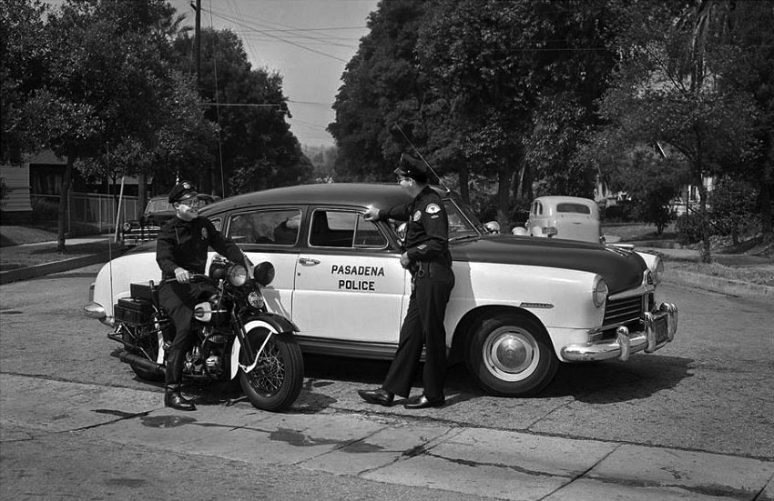
| (1950)* - Keeping the peace in Pasadena. The police car is a 1950 Hudson. |
* * * * * |
Rose Parade
 |
|
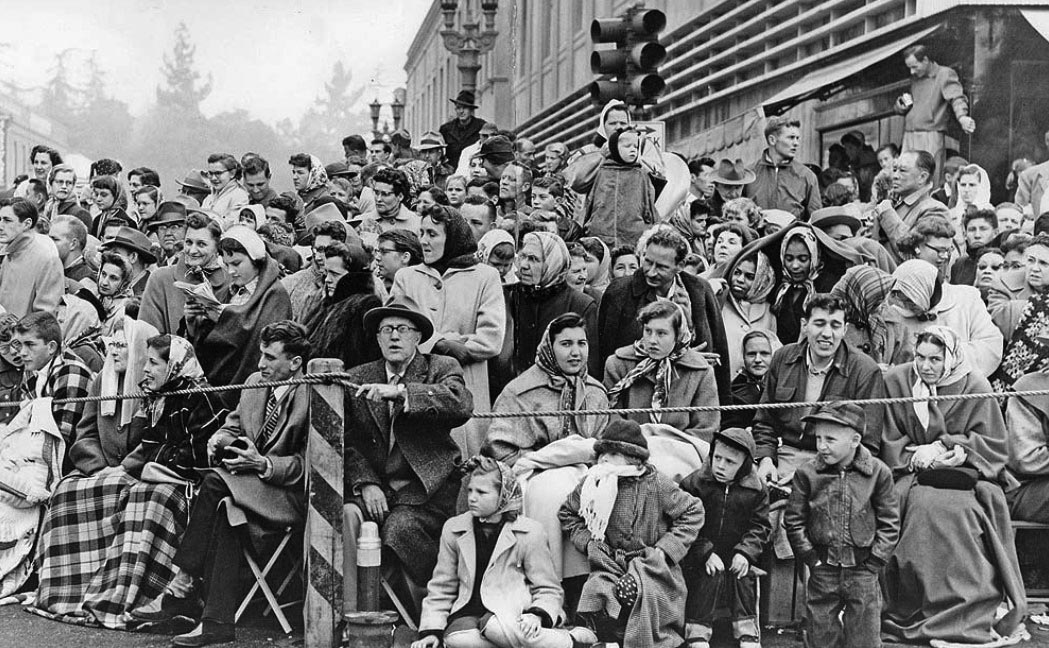
| (1955)* – Spectators brave the cold weather to watch the 1955 Rose Parade. This appears to be the N/E corner of Colorado and Fair Oaks. LA Times Photo |
Historical Notes Low of 46 and a high of 57 that New Year's Day in 1955. That's cold for Southern California The Rose Parade in the 1950s was a vibrant and evolving event marked by notable moments and developments. In 1952, the parade faced a challenge when a group threatened to vandalize floats, with the South Pasadena entry cleverly depicting a political metaphor featuring an elephant with rose-colored sunglasses to symbolize the transition from Truman to Eisenhower. The decade also saw significant contributions, such as the 1959 donation of the Wrigley Mansion and Gardens to Pasadena for use as the Tournament of Roses headquarters. One of the most dramatic incidents occurred that same year when South Pasadena's float, featuring a life-sized elephant with an 11-person crew, encountered multiple challenges, including the driver passing out from extreme heat and a fire in the electrical generator. Despite these setbacks, the float completed the parade and won the Mayor's Trophy for the most outstanding city entry. Overall, the Rose Parade continued to grow in popularity during the 1950s, showcasing elaborate floats, marching bands, and equestrian units while remaining a significant annual event in Pasadena. |
 |
|
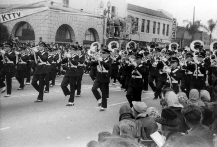
| (1950)* – View showing a marching band at the 1950 Rose Parade with Orth's Mayflower Warehouse and a camera boom for KTTV TV visible in the background. The 1949 Pasadena City Directory lists Orth Van and Storage at 238 W. Colorado Boulevard. It looks cold out there… |
 |
|
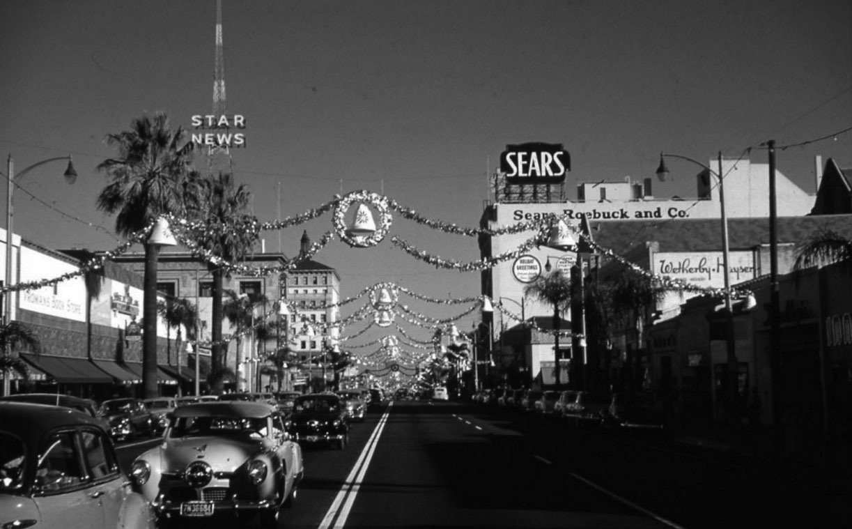
| (ca. 1950)* – View looking east on Colorado Boulevard from Los Robles Avenue during the holiday season. The Star News radio tower at Oakland Avenue is on the left. Sears and Wetherby Kayser can be seen on the right. |
* * * * * |
Howard Motor Company Building
 |
|
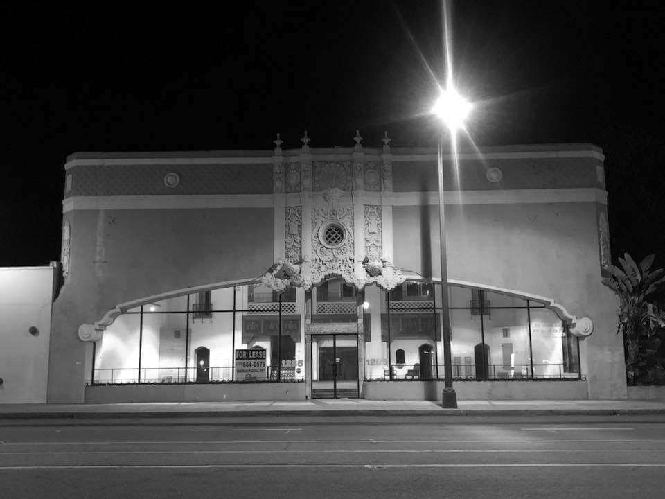
| (n.d.)* - View showing the 1927-built Howard Motor Company Building located at 1285 E. Colorado Blvd. Photo courtesy of David Hermann |
Historical Notes The Howard Motor Company built the showroom in 1927; it was one of several car dealerships built along Colorado Boulevard. The building has a Spanish Colonial Revival design with Churrigueresque ornamentation; its design includes a decorative frieze, chanfered corners, and an elliptical arched entrance topped by the dominant Churrigueresque element. The Bush-Morgan Motor Company moved into the building in 1938 and occupied it through the 1950s. Most early Pasadena automobile dealers located their showrooms on Colorado Boulevard. Two groupings developed: one on a two-block stretch of West Colorado Boulevard between Orange Grove Boulevard and downtown, and the other located in the then-geographic center of the city along East Colorado Boulevard between Lake and Hill Avenues. Built in 1927, the Howard Motor Company Building was one of several auto-related buildings located along East Colorado Boulevard, and it was among the showiest. |
 |
|
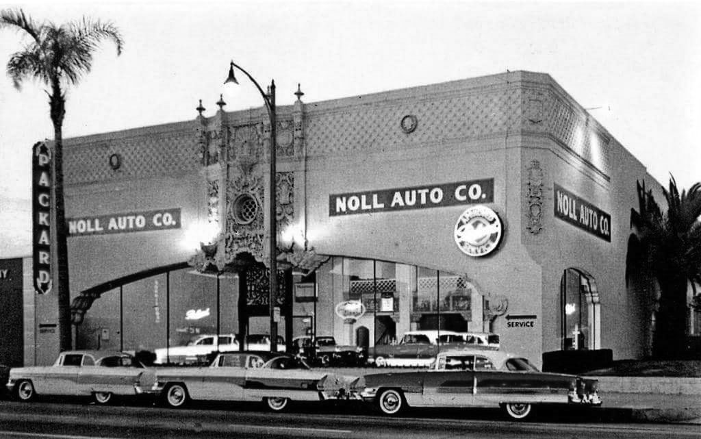
| (1956)* – Postcard view showing the Noll Auto Co., Packard Dealership, located in the old Howard Motor Company Building. Courtesy of Alden Jewell |
Historical Notes The last "real" Packards went out in a blaze of glory at this dealership. By 1957 imported makes were sold here by Noll-Baldwin Motor Co., including Hillman, Sunbeam, Jaguar, Simca, Triumph and Volvo. In the early '70s it was Pasadena Mazda, followed by California Custom Coach (which made replica Auburn Speedsters), and, finally, Acura of Pasadena until 2005. The building was also an Aaardvark’s Odd Ark clothing store in the 90s. |
 |
|
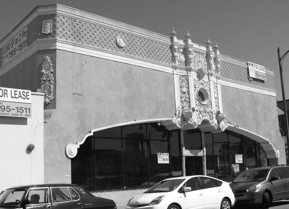
| (2008)* – View showing a vacant Howard Motor Company Building, 1285 E. Colorado Blvd in Pasadena. Photo courtesy of Roadside Architecture |
Historical Notes With considerable growth in the automobile industry during the 1920s, competition among dealers was fierce. It was not unusual for dealerships to move often, each time seeking a more elaborate or advantageous location. When builders constructed the Howard Motor Company building in 1927, Churrigueresque was an apt choice. The exterior of the building is richly ornamented. Corners are chamfered and topped with a broad ornamental frieze. Showroom windows and entry doors are recessed in a single elliptical arch, which spans the entire street facade. The arch has a grooved mold that terminates in unusual scrolled imposts. ^ The building was added to the National Register of Historic Places on April 18, 1996. Click HERE for contemporary street view. |
 |
|
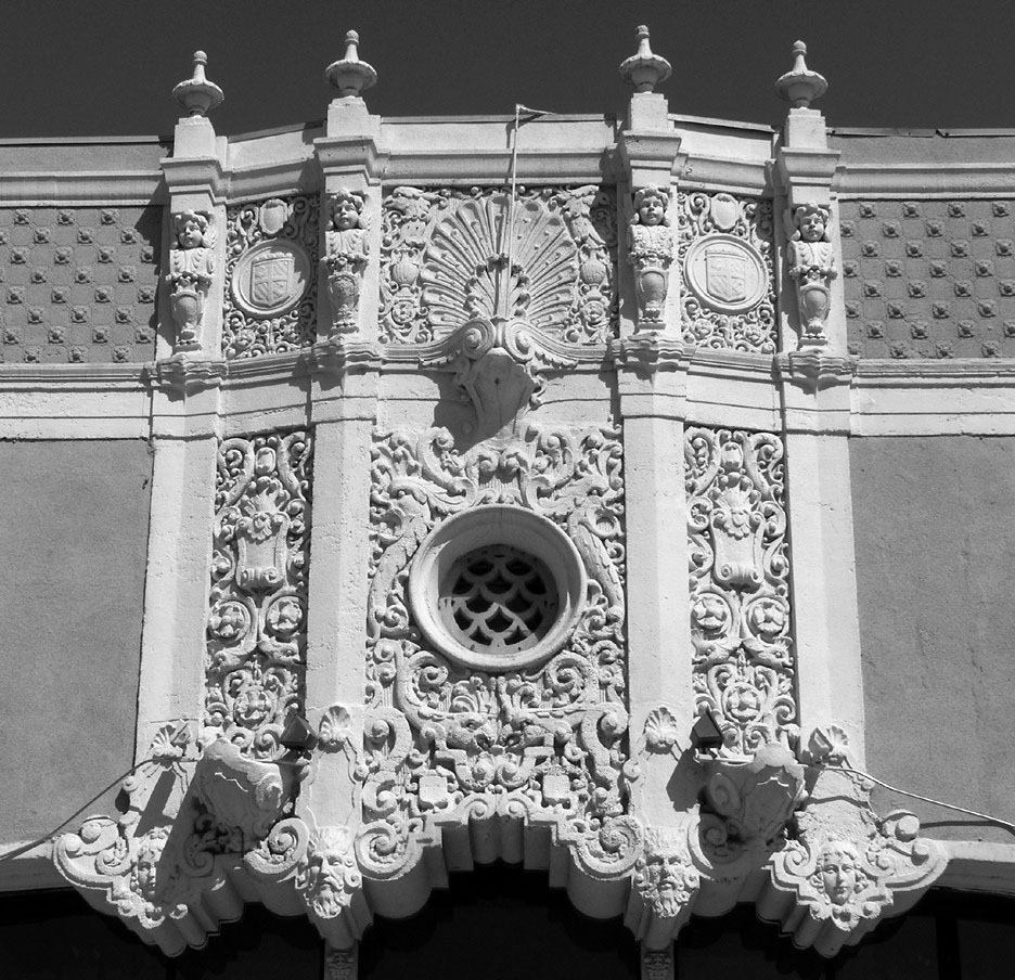
| (2008)* – Close-up detail view showing the Churrigueresque-style design above the entrance to the Howard Motor Company Building. Photo courtesy of Roadside Architecture |
Historical Notes “Churrigueresque” is the ornate, sculpted, baroque architectural style of the Howard Motor Company Building. Popularized in Spain during the late 17th and early 18th centuries, Churrigueresque was revived during the 1915 Panama-California Exposition in Balboa Park, San Diego. In the years between World War I and World War II, the country entered the age of the automobile, and this high-relief style worked particularly well in the expanding California automotive market where dealers competed fiercely for attention and for sales. ^ |
* * * * * |
Colorado and Fair Oaks
 |
|
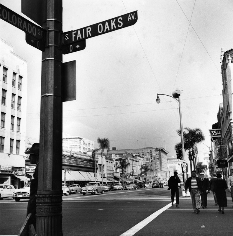
| (1954)* - View is looking east on Colorado Boulevard from Fair Oaks in Pasadena. J.J. Newberry's can be seen on the left side of the street. On the other side of the street is the still popular dive bar, Freddie's 35er. |
 |
|
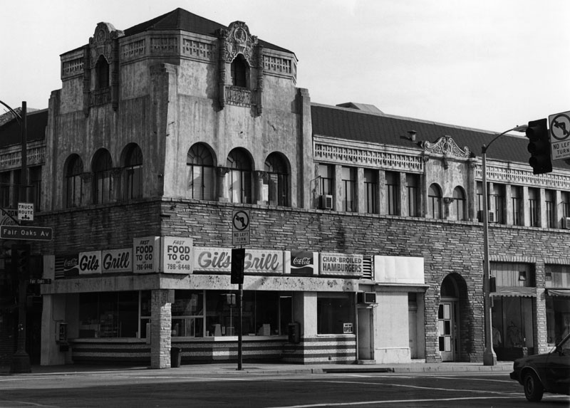
| (1989)* - Gil's Grill, a small street corner carry-out restaurant located at Colorado and Fair Oaks Boulevards. |
* * * * * |
Pasadena Winter Garden
 |
|
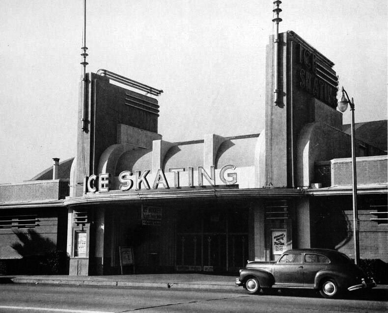
| (ca. 1940)* - A car is parked in front of the Pasadena Winter Gardens, located at 171 S. Arroyo Parkway. |
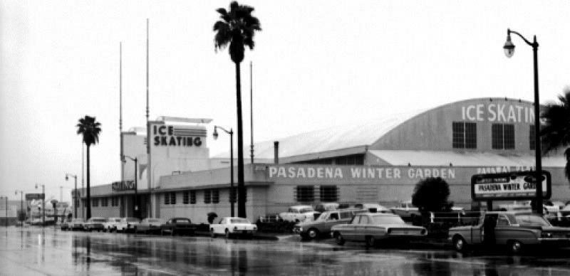
Historical Notes Built in 1940, Pasadena Winter Garden was located at 171 S. Arroyo Parkway, not far from Colorado Blvd., the main drag of Pasadena. It was the home of the Blade and Edge Figure Skating Club and is most renowned for being the original home of World and Olympic champion Peggy Fleming. |
 |
|
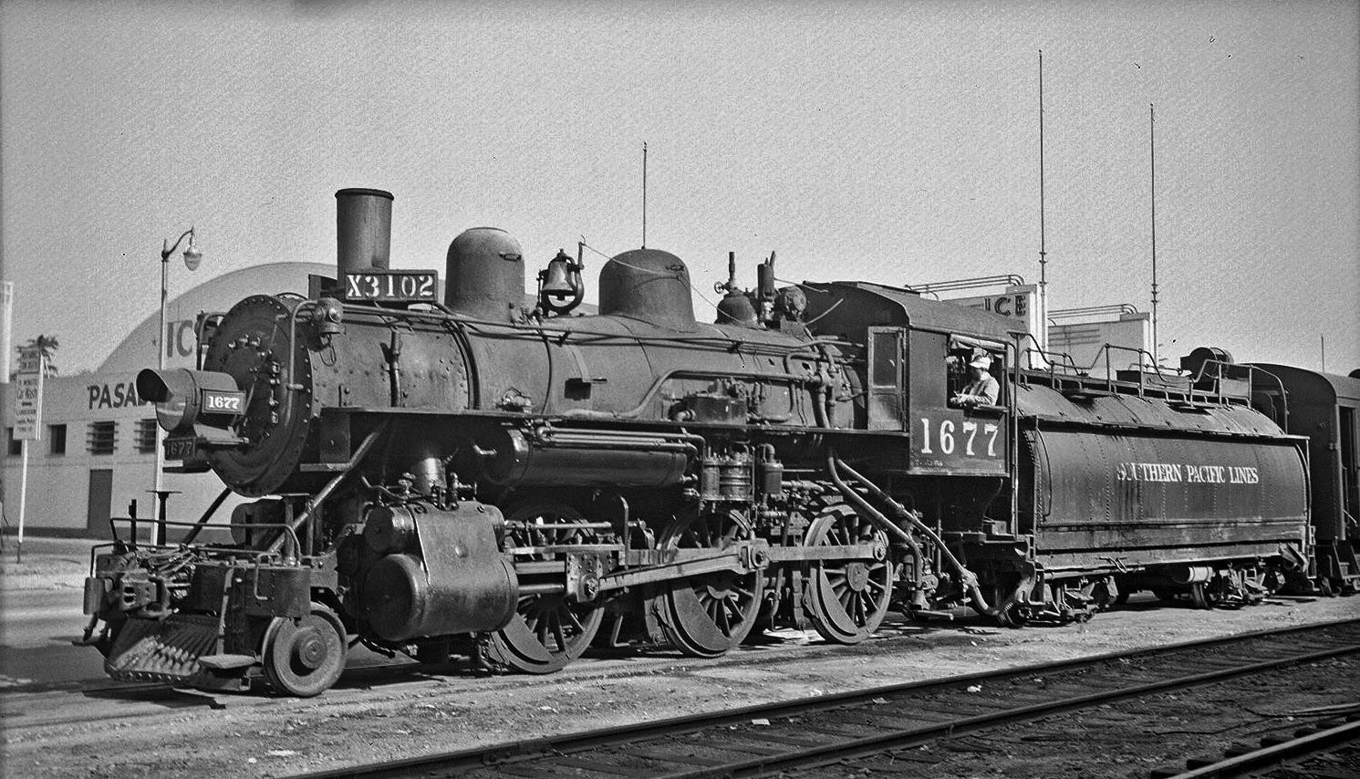
| (1946)* – View looking northwest showing SP Engine No. 1677 at what is now the corner of Arroyo Parkway and Cordova Street, Pasadena. After a short pause the engine and its train of freight cars will return to the main line junction in Alhambra. Note the Pasadena Winter Garden behind the engine. Photo courtesy of Paul Ayers |
 |
|
| (1960s)* – View looking south on Arroyo Parkway on a rainy day showing the Pasadena Winter Garden. |
 |
|
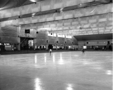
| (1960s)* – Interior view showing the ice rink at the Pasadena Winter Garden. |
Historical Notes Pasadena Winter Garden was home to the Pasadena Panthers, one of four teams in the California Ice Hockey League in the 1950s. The league contained four teams, who were vying for ice time in the three-rink Los Angeles basin. The rink closed December 31, 1966 and the wonderful art deco exterior was all that remained when it was converted to a U. S. Post Office facility. However, the permafrost caused such serious discomfort to postal workers that the facility was closed. It sat vacant for some years and is now a Public Storage facility. |
* * * * * |
 |
|
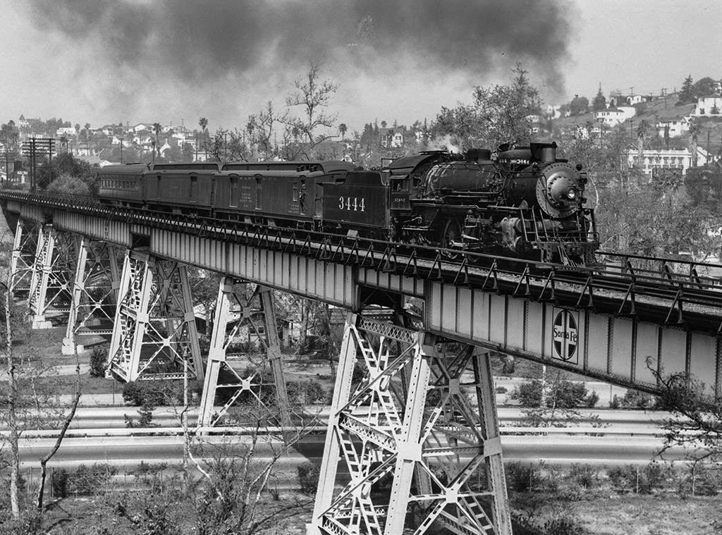
| (ca. 1949)* - A Santa Fe mail train crosses the Arroyo Seco (and Route 66) near South Pasadena behind engine no. 3444. Today the bridge carries Metro's Gold Line over the Pasadena Freeway. Photo: Donald Duke / Los Angeles Railroad Heriitage Foundation |
 |
|
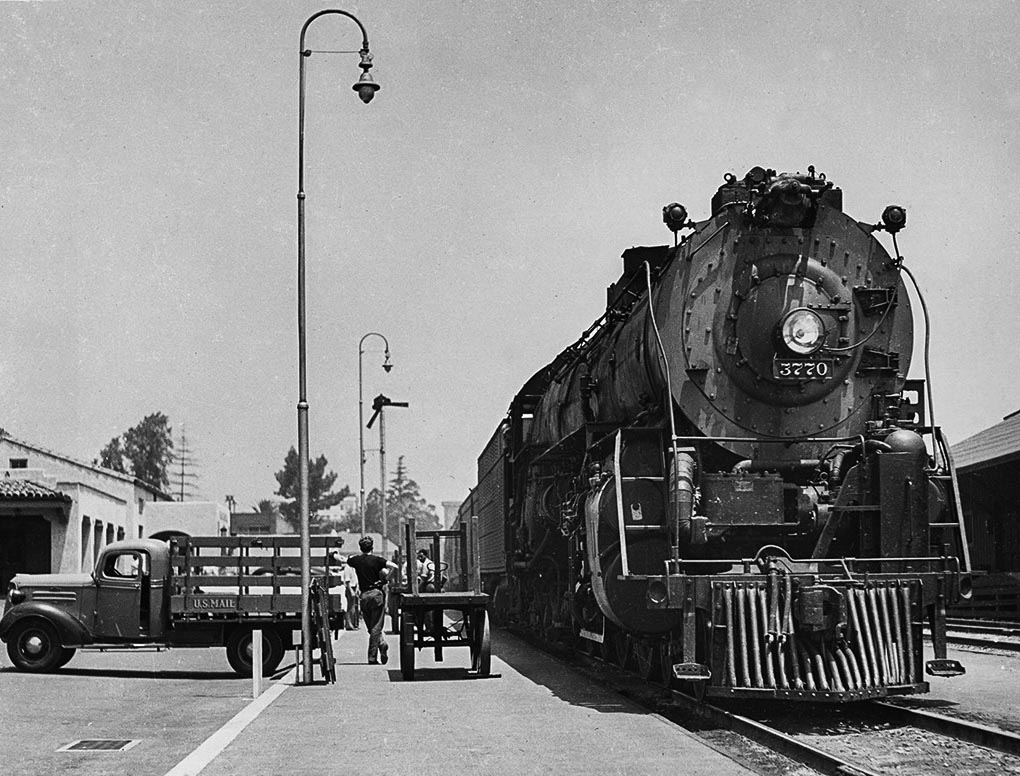
| (1949)* - Santa Fe no. 3770 with a westbound passenger train waits at the Santa Fe Train Station in Pasadena. Photo: Donald Duke / Los Angeles Railroad Heriitage Foundation |
 |
|
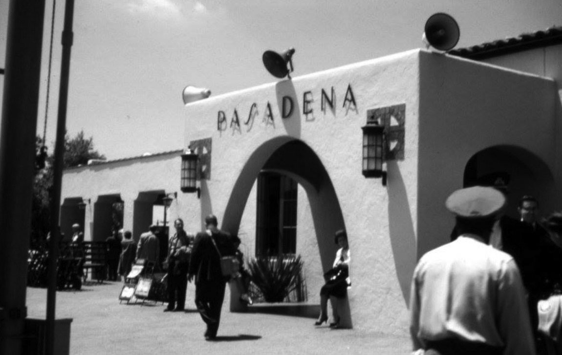
| (1961)* – View showing the Santa Fe Railway Station in Pasadena. The man with the cap in the lower-right corner is the porter to help you with the luggage. The square symbol behind the two lights is the logo for the Atchison, Topeka and Santa Fe Railway. Photo courtesy Martin Turnbull |
Historical Notes The Santa Fe Railway’s Mission Revival-style passenger station on Raymond Ave. in Pasadena opened in 1935. In the heyday of train travel, this station was favored by celebrities who didn’t want to have to deal with the whole “Movie Star Arrives in Los Angeles” press circus, and preferred to quietly arrive in town and sneak back home. So they’d get out at the station before Union Station in downtown L.A. – and that was this one. |
 |
|
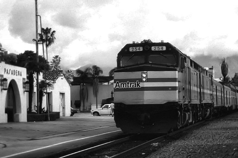
| (1980s)* – View showing an Amtrak train arriving in Pasadena from Chicago. |
Historical Notes This scene has changed drastically with the arrival of Metro's Gold Line, but the depot survives as a restaurant surrounded by high-rise living. |
* * * * * |
 |
|
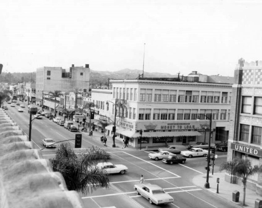
| (ca. 1970)* - Old Town Pasadena intersection of Colorado and Raymond. Crown City Loan & Jewelry is the most visible business along this stretch of Colorado Blvd. |
 |
|
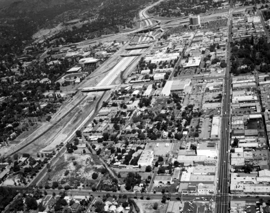
| (1970s)* – Aerial view looking north showing the newly constructed freeway system of the 1970's. Landscaping to beautify the freeway had not yet been done. Saint Andrew's Church on Raymond Street can be seen in the upper right corner of the photo just south of the 210 freeway. A few blocks below on Raymond Street is the Hotel Green next to Central Park. West of Raymond Ave. is Fair Oaks Avenue. Bekins Storage Co. is on the lower right of the photo. The Rose Bowl stadium is near the upper left corner. |
 |
|
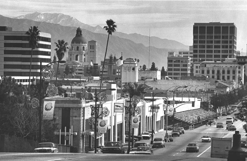
| (ca. 1986)* - Scenic view of Colorado Boulevard in Pasadena. Banners hanging from light poles, read: "Pasadena Tournament of Roses," and bleachers are set up for the Rose Parade. The Pasadena City Hall appears on the left in front of the San Gabriel mountains, seen in the distance. |
 |
|
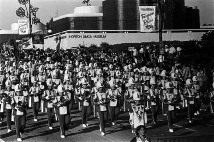
| (n.d.)#^ - The Pasadena City College Band marching in the Rose Parade in front of Norton Simon Museum. |
* * * * * |
Pasadena Pioneers Bridge - Planning and Preservation (1951)
 |
|
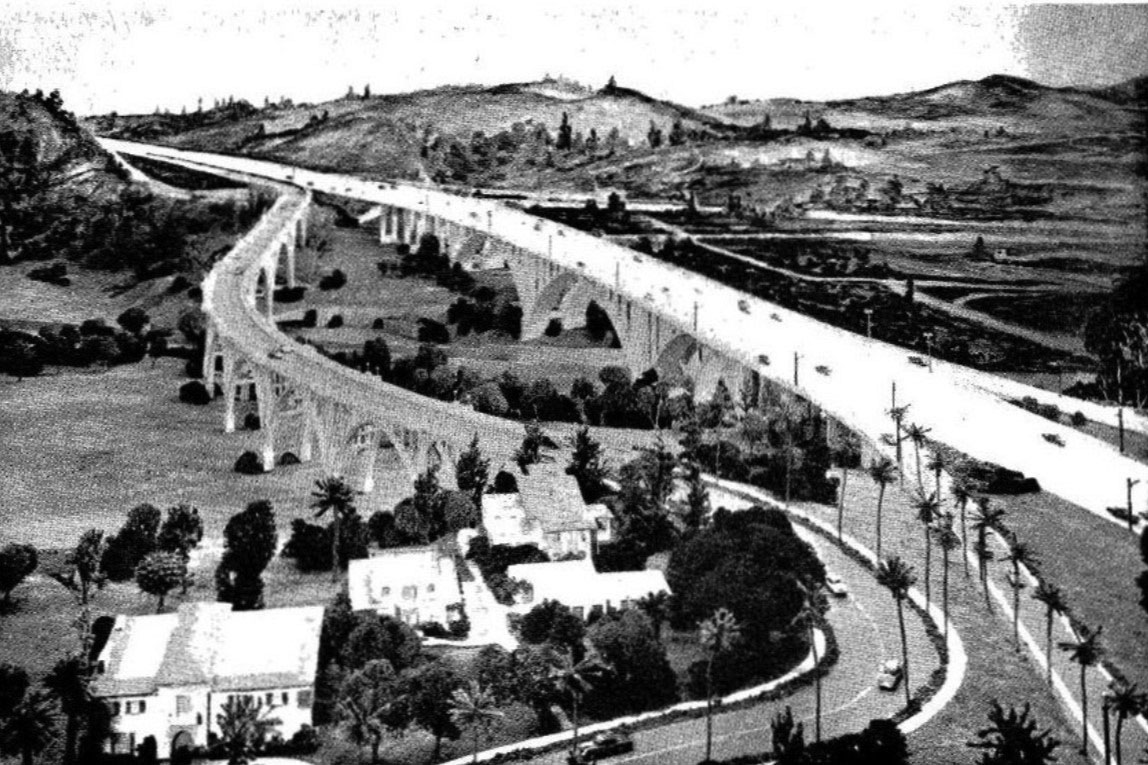
| (1951)* - This sketch shows the general relation of the existing and proposed Colorado Street bridges in Pasadena. This finished appearance is by Bridge Department artist Van Der Goes who retouched a photograph of a model of the bridge. |
Historical Notes When the Foothill (210) Freeway was planned in the early 1950s, the California Department of Transportation made known its intention to demolish the Colorado Street Bridge. But after much public outcry and appeals from the City of Pasadena and other organizations, Caltrans allowed the bridge to stand and built their own bridge parallel to it. |
 |
|
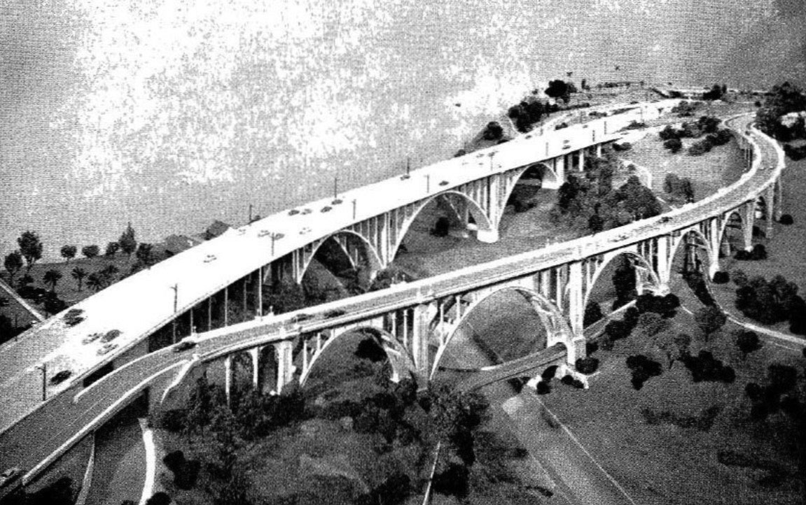
| (1951)* – Conceptual design sketch showing the original Colorado Street Bridge with the newly proposed Colorado Freeway Bridge (later Pasadena Freeway Bridge). |
Historical Notes Pasadena Pioneers Bridge is named for the party of settlers led by Dr. T.B. Elliot, a physician who held meetings in his Indianapolis home for people interested in moving to California and settling where the sun would shine year-round. After extensive fact-finding, the party of settlers came by train, then boat, then wagons to what became the Indiana Colony. Note: The planned Colorado Freeway was later incorporated into U.S. 101 Bypass and, in 1964, redesignated as State Route 134, the Ventura Freeway. |
* * * * * |
Construction of the Pioneers Bridge (1951–1953)
 |
|
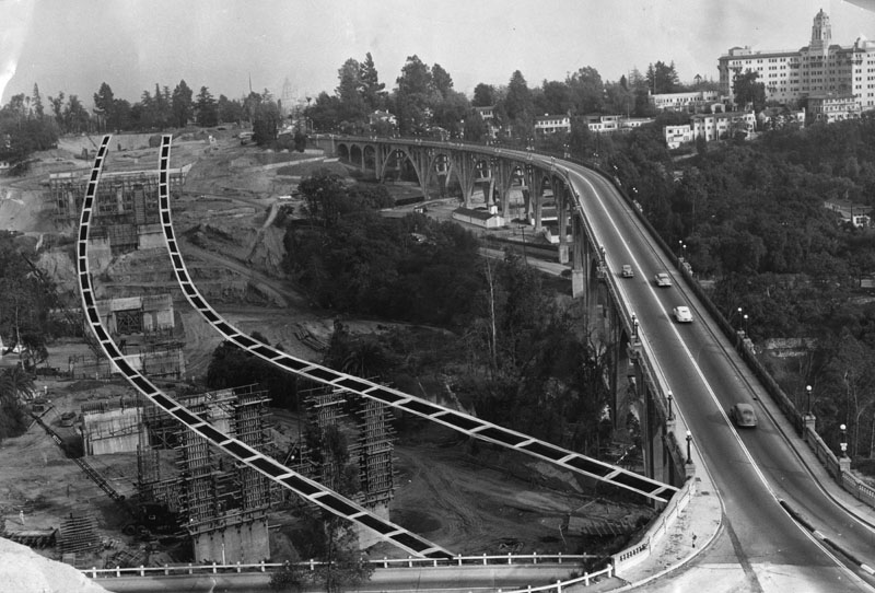
| (1951)* - Construction of the Pasadena Pioneers Bridge, also known as the Colorado Freeway Bridge, begins just north of the Colorado Street Bridge. The Vista Del Arroyo Hotel can be seen in the background. |
Historical Notes Groundbreaking took place in 1951 as automobile traffic on the 1913 Colorado Street Bridge had reached unsafe levels. At times, restrictions were even placed on traffic during peak hours. The new bridge, part of the planned Colorado Freeway, was intended to relieve congestion and serve the region’s growing need for modern, high-capacity roads. The freeway itself would later be redesignated as State Route 134 and is known today as the Ventura Freeway. |
 |
|
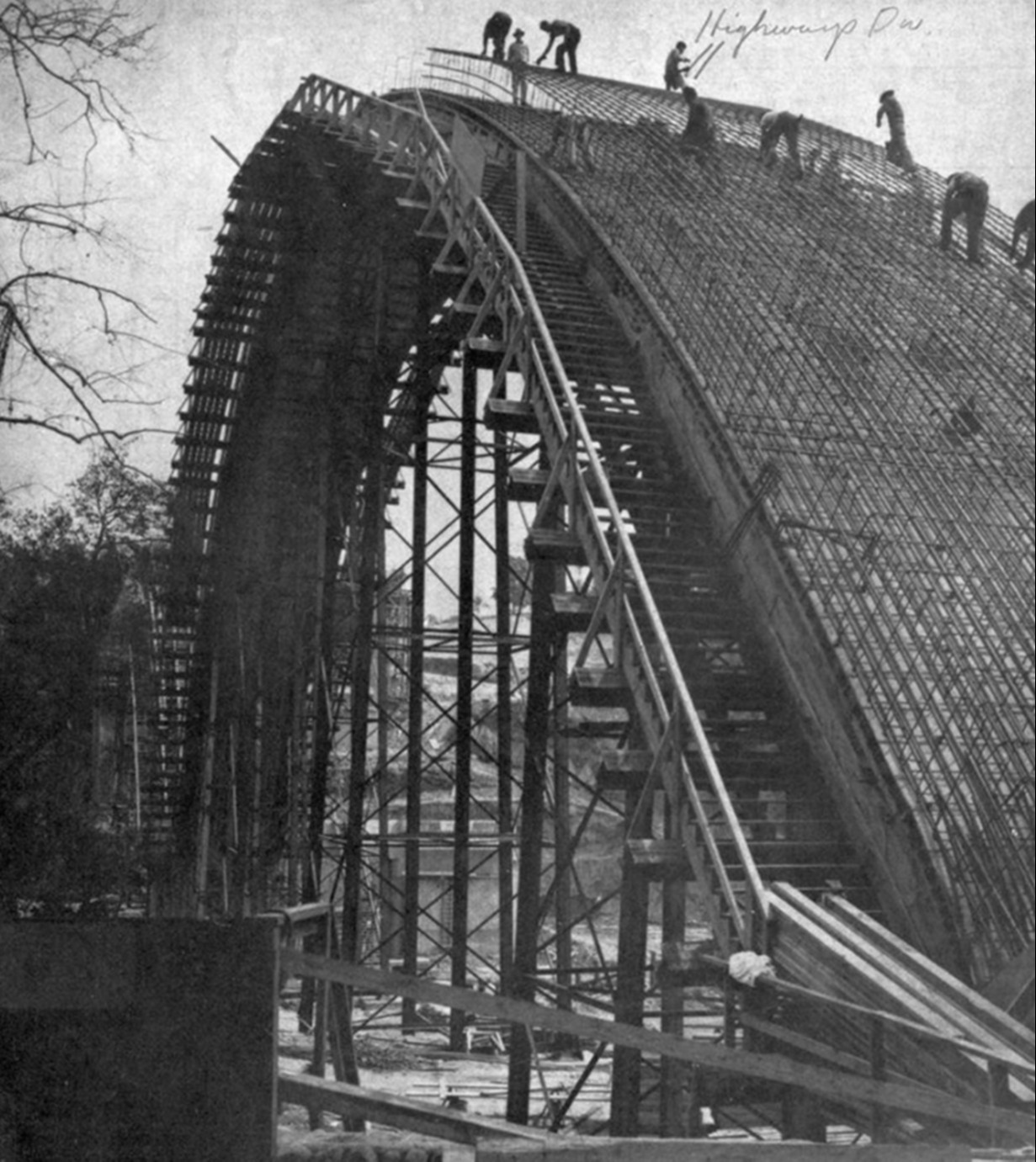
| (1952)* – Construction advances with the massive arches of the Pasadena Pioneers Bridge rising over the Arroyo Seco. |
Historical Notes The Pioneers Bridge was one of the most ambitious public works projects of its era. More than 41,000 cubic yards of concrete and 5.5 million pounds of reinforced steel went into its construction. While the new bridge echoed the arch form of the Colorado Street Bridge, it was built on a larger scale to handle the demands of freeway traffic. |
 |
|
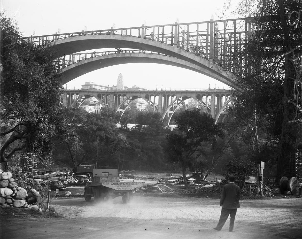
| (1952)* - Construction of the Pasadena Pioneers Bridge (Colorado Freeway, later SR-134) over the Arroyo Seco. The massive new structure rose immediately north of the 1913 Colorado Street Bridge, which can be seen beneath its emerging arches in the background. |
Historical Notes By 1952, the outlines of the new bridge revealed how closely it paralleled the older crossing. The side-by-side contrast symbolized Pasadena’s growth: the Colorado Street Bridge represented early 20th-century expansion, while the Pioneers Bridge embodied mid-century modernization. Together, they would become a striking architectural pair across the Arroyo Seco. |
 |
|
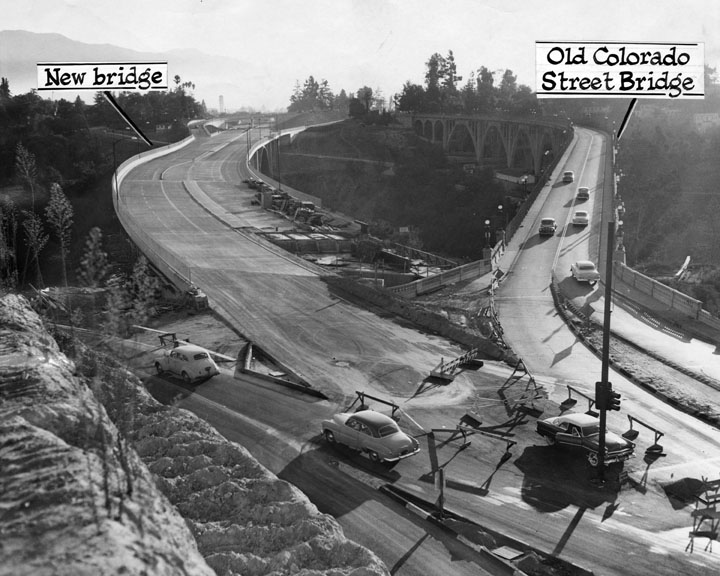
| (1953)* - A new bridge, now the Ventura Freeway, is built over the Arroyo Seco. The Colorado Street Bridge is on the right. This photo appeared in the May 25, 1953 Los Angeles Times. |
Historical Notes By spring 1953, the great arch ribs and spandrels were in place, and crews were forming the deck and approaches. Built immediately north of the 1913 Colorado Street Bridge, the new crossing was designed to carry the heavy flow of freeway traffic that the older structure could no longer accommodate. The westbound lanes were scheduled to open later that fall. |
 |
|
| (1953)* - Another view showing the almost-completed Pasadena Pioneers Bridge beside the Colorado Street Bridge. |
Historical Notes As the bridge neared completion, its scale was unmistakable: 1,364 feet long and 131 feet high, with three great spans. Using more than 41,000 cubic yards of concrete and 5.5 million pounds of steel, it cost $6.5 million—at the time, the largest bridge project ever undertaken by the State of California. Though functional in form, it was deliberately shaped to harmonize with the arches of its historic neighbor. |
Dedication and Naming (1953)
 |
|
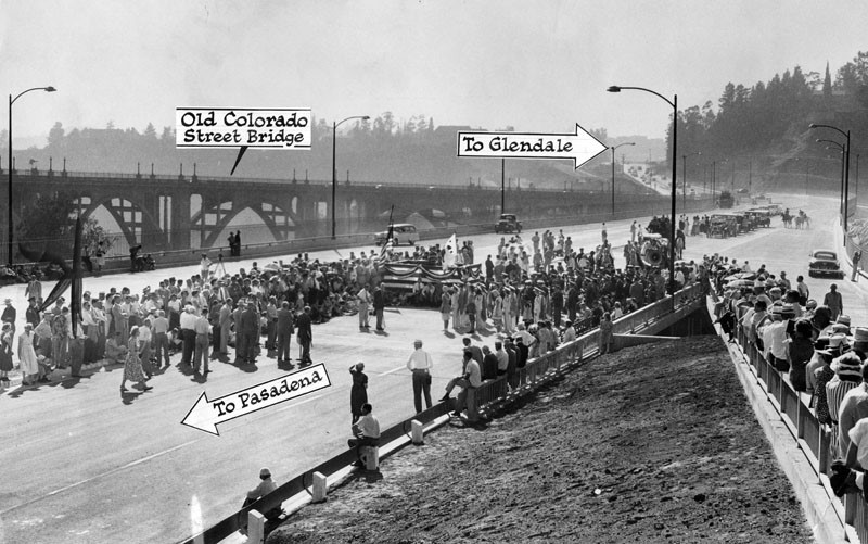
| (1953)* - Hundreds of spectators attend the ribbon-cutting marking the opening of one half of the bridge (westbound lanes). Photo dated October 9, 1953. |
Historical Notes The dedication on October 8, 1953, honored Pasadena’s pioneers, especially the 27 founders who settled nearby in 1874. A commemorative plaque placed on Orange Grove Boulevard overlooks the bridge and records the occasion: “Pasadena Pioneer Bridge erected by the California Commission and the Division of Highways of the Department of Public Works, named by resolution of the 1953 state legislature and dedicated to all Pasadena pioneers especially the twenty-seven who founded this city near this spot on January 27, 1874. Dedicated October 8, 1953 by the City of Pasadena and a committee of citizens grateful for our illustrious past and committed to a more glorious future.” |
* * * * * |
Pioneers Bridge and Colorado Street Bridge
 |
|
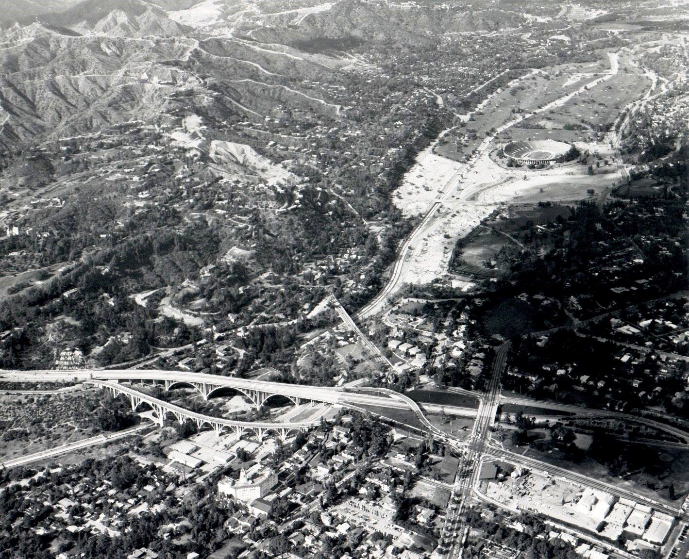
| (1966)* - Aerial view looking north up the Arroyo Seco, showing both the Colorado Street Bridge and the newly completed Pioneers Bridge, with the Rose Bowl in the distance. |
Historical Notes Seen together, the two bridges highlight Pasadena’s layered history. The Colorado Street Bridge, built in 1913, was the first major high-level crossing of the Arroyo Seco. The Pioneers Bridge, dedicated 40 years later, carried State Route 134 and marked the city’s embrace of the freeway age. Together, they illustrate Pasadena’s transition from the streetcar era to the automobile era. |
 |
|
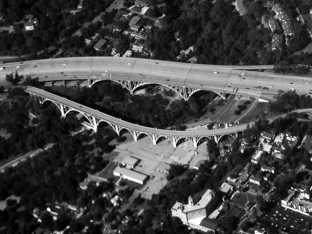
| (2010)* – Closer view of the Colorado Street Bridge next to the bridge for the Ventura Freeway, also known as the Pasadena Pioneer Bridge. The old Vista del Arroyo Hotel (today, United States Court of Appeals) can be seen in bottom right of photo. Photo by Bobak Ha'Eri / Wikipedia. |
Historical Notes The Colorado Street Bridge is admired for its Beaux Arts design, with graceful arches and ornate details. By contrast, the Pioneers Bridge was built with bold, functional forms suited for heavy freeway traffic. Though their purposes differ, the two bridges complement one another and remain enduring landmarks of Pasadena. |
 |
|
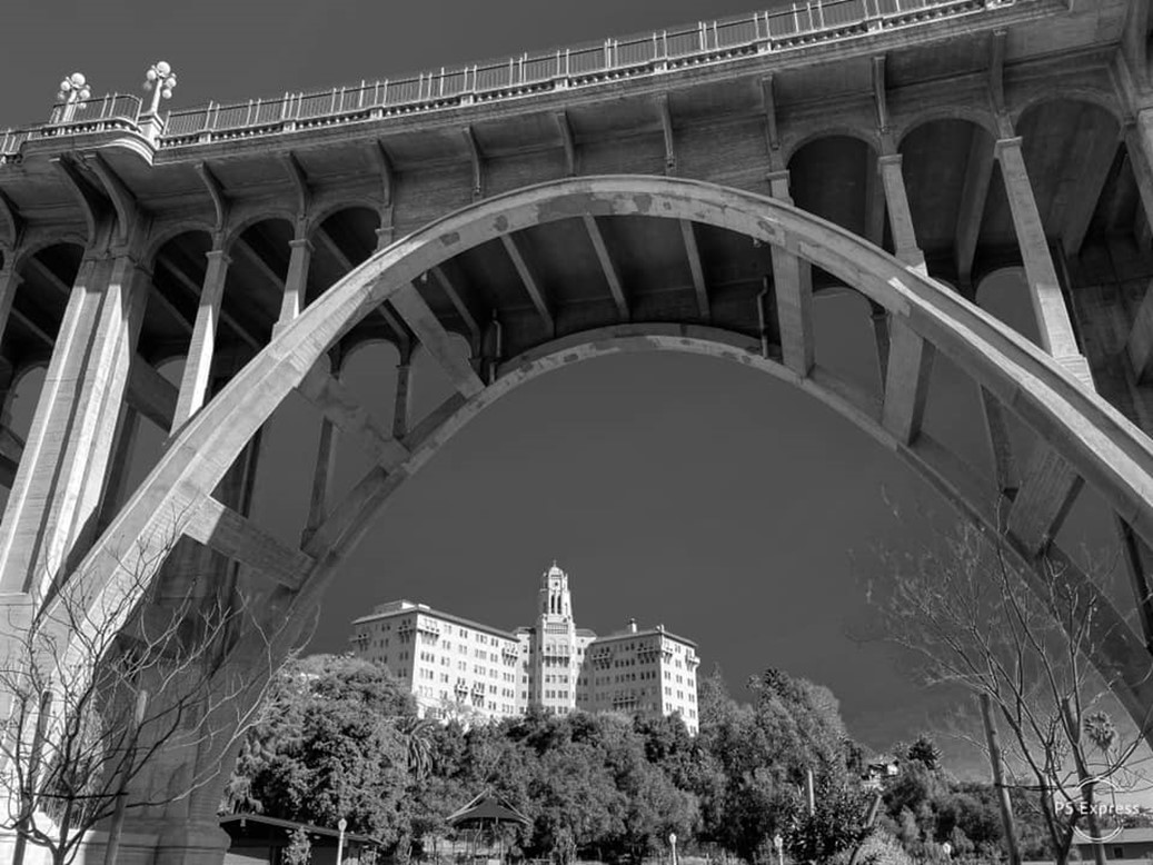
| (2021)* – The Colorado Street Bridge with the United States Court of Appeals (formerly the Vista del Arroyo Hotel) in the distance, Pasadena. Photo by Jim Bartley. |
Historical Notes Originally opened as the Vista Del Arroyo Hotel in 1882 and later expanded in the 1920s, the building was converted into a military hospital during World War II. In 1985 it was adapted for use as a federal courthouse. Its presence adds another layer of history to the Arroyo Seco, standing alongside two of Pasadena’s most important bridges. |
 |
|
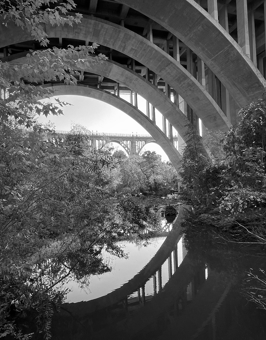
| (2022)* - Looking through the arches of the Ventura Freeway Bridge (Pasadena Pioneers Bridge) toward the Colorado Street Bridge. Courtesy of Tavo Olmos |
Historical Notes Both bridges feature dramatic arches, but they tell different architectural stories. The 1913 Colorado Street Bridge embodies elegance and craftsmanship of its time, while the Pioneers Bridge reflects mid-20th-century engineering on a grand scale. Together, they form a powerful visual dialogue between Pasadena’s past and its modern era. |
 |
|
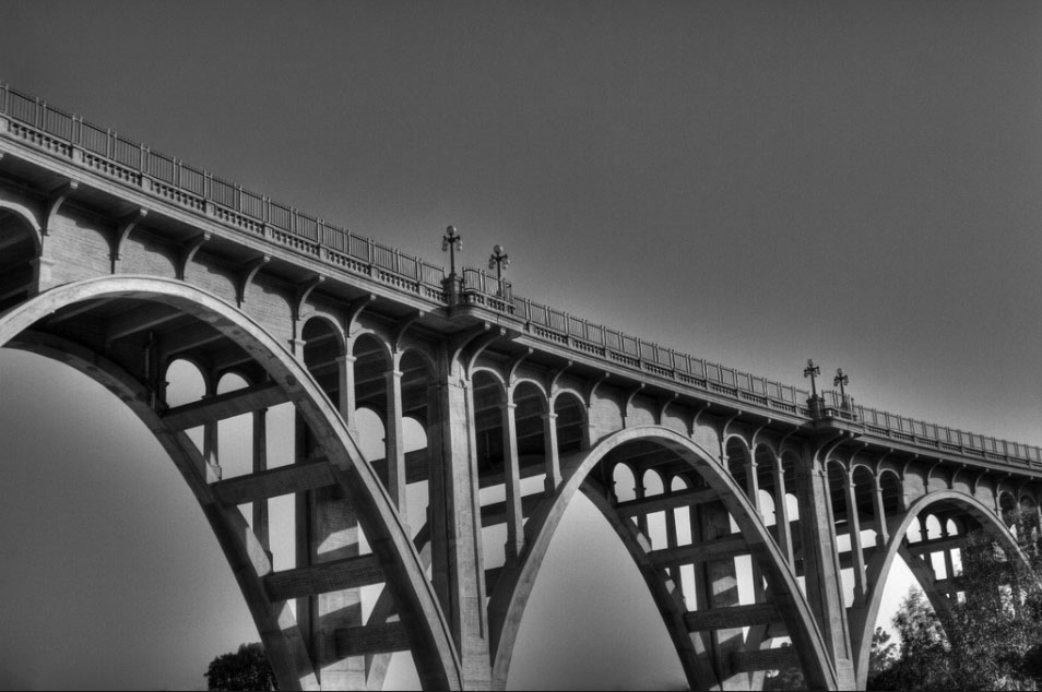
| (2007)* - View showing the majestic Colorado Street Bridge spanning the Arroyo Seco. Photo by Bernard Tang |
Historical Notes Once the tallest concrete bridge in the world, the Colorado Street Bridge quickly became one of Pasadena’s most recognized landmarks. Listed on the National Register of Historic Places and named a Historic Civil Engineering Landmark, it remains an icon of early Los Angeles County infrastructure. Though often remembered for its somber nickname, “Suicide Bridge,” ongoing preservation and safety efforts highlight the city’s commitment to both honoring and protecting this historic structure. |
* * * * * |
Rose Bowl
 |
|
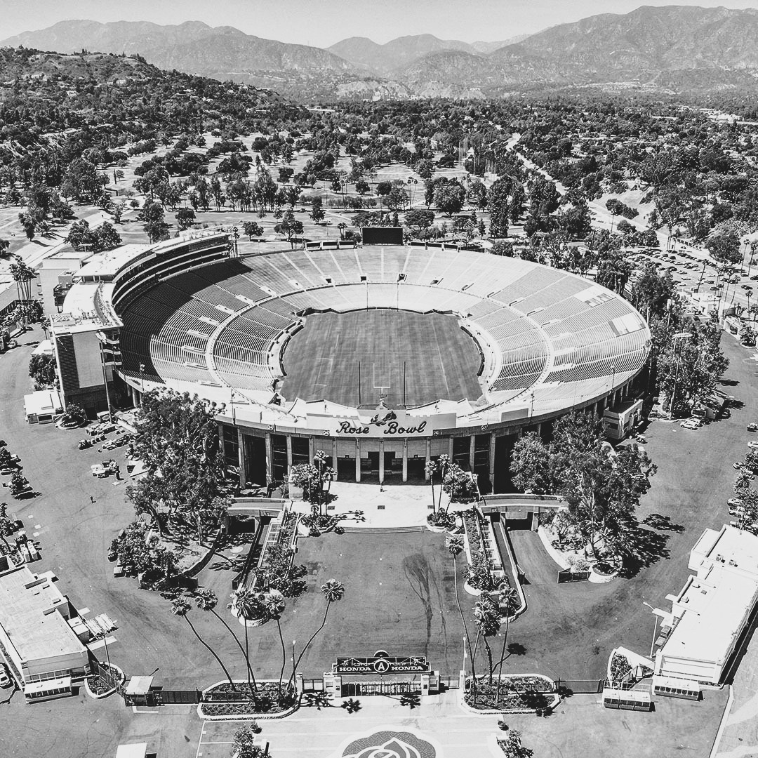
| (2022)* - Rose Bowl Today. Photo by Ted Eytan / Los Angeles Conservancy |
Historical Notes The Rose Bowl stadium in Pasadena is a historic landmark renowned for its cultural and architectural significance. Completed in 1922 and designed by architect Myron Hunt, the stadium draws inspiration from classical Greek and Roman coliseums, with its elliptical shape offering optimal sightlines for spectators. Its timeless design and functionality have made it a cornerstone of American sports history. |
 |
|
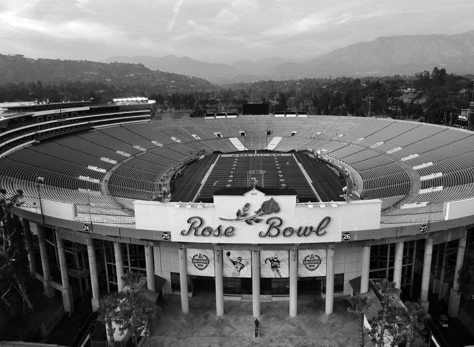
| (2018)^.^ – Contemporary view of the Rose Bowl. |
Historical Notes Since its opening, the Rose Bowl has hosted numerous iconic events, including five Super Bowls, Olympic soccer matches, FIFA World Cup Finals, and the annual Rose Bowl Game. Designated a National Historic Landmark in 1987, the stadium has maintained its architectural integrity through several expansions. These events have cemented its place as one of the most celebrated venues in the world, blending historic significance with modern relevance. |
 |
|
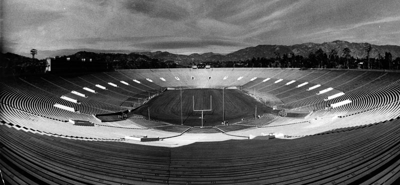
| (1987)* - It looks empty here, but the Rose Bowl is anything but on New Year's Day, when 100,000-plus fans rock the stadium. |
Historical Notes Built in just nine months using local materials, the Rose Bowl originally seated 57,000 spectators but now accommodates over 100,000. Its design seamlessly combines early 20th-century architectural principles with classical influences, creating a venue that is both functional and visually striking. Today, it stands as a cherished symbol of Pasadena’s rich sporting and architectural heritage, continuing to inspire generations of fans and visitors. |
* * * * * |
City Hall
 |
|
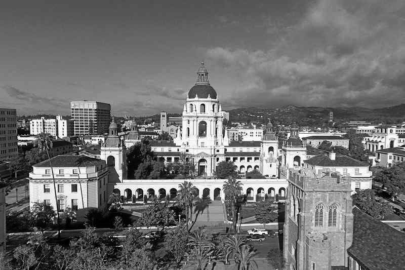
| (2014)* – Aerial drone view of the beautiful Pasadena City Hall. Photo by Phil Coombes |
Historical Notes On July 28, 1980 the Civic Center District, including Pasadena City Hall, was listed on the National Register of Historic Places. |
* * * * * |
Please Support Our CauseWater and Power Associates, Inc. is a non-profit, public service organization dedicated to preserving historical records and photos. Your generosity allows us to continue to disseminate knowledge of the rich and diverse multicultural history of the greater Los Angeles area; to serve as a resource of historical information; and to assist in the preservation of the city's historic records.
|
More Historical Early Views
Newest Additions
Early LA Buildings and City Views
History of Water and Electricity in Los Angeles
* * * * * |
References and Credits
* LA Public Library Image Archive
^*California Historic Landmark Listing (Los Angeles)
^#South Pasadena Middle School Home Page
#* Huntington Digital Library Archive
## Google Maps
++ Squareone.org: Pasadena Winter Garden
^^*LA Times Framework: Palomar Telescope
*^^Nuestra Señora la Reina de los Ángeles: losangelespast.com
***Pasadena Museum of History: Pacific Electric Railway Then and Now
**#Metro Transportation Library and Archive
+**Automobile in American Life and Society
++*Estately Blog: Colorado Street Bridge Postcard
+++Facebook.com – Los Angeles Heritage Railroad Museum
#+#Facebook: Hollywood's Garden of Allah novels, by Martin Turnbull
^++Pomona Library Image Archive
+^+Pasadena: A Business History: The Model Grocery
^+^Master Plan of Highways - County of Los Angeles
^*#Noirish Los Angeles - forum.skyscraperpage.com; Oak Knoll PE Line
*#*KCET: Colorado Street Bridge; L.A.'s First Freeways
*##Los Angeles Movie Palaces: Fox Pasadena
#^^Hometown Pasadena: Tower Theatre
#^#Pyroil - The Wonder Gas: theoldmotor.com
#*#Pasadena Adventure: walknridela.com
##*The Pasadena Civic - History
##+Waymarking.com: First Church of Christ, Scientist Pasadena
**^^Cinema Treasures: Florence - State Theatre; Tower Theatre
*^^*Pasadena: A Busines History
^***Facebook.com: I Grew Up in San Gabriel Valley: Colorado Blvd.
^^**Cruiselinehistory.com: Pasadena Santa Fe Station – Gateway to Hollywood
^^*#Facebook.com - Pasadena Digital History
^++^Facebook: Los Angeles Heritage Railroad Foundation
#^^*Pasadena Star News: Pasadena Civic Auditorium; Drone View of Pasadena City Hall; Pasadena Playhouse
#^^^The City of Pasadena - cityofpasadena.net: Central Library
##++Flickr.com: Boston Public Library
++##Facebook:AmericarTheBeautiful
**##Eating L.A. - Guinn's Coffee Shop and Drive-in
*^ Wikipedia: History of Pasadena; Tournament of Roses Parade; The Langham Huntington; Hotel Green; Rose Bowl Game; Pasadena City Hall; Old Town Pasadena; Los Angeles Terminal Railway; Richard H. Chambers United States Court of Appeals and the Vista del Arroyo Hotel and Bungalows; California Institute of Technology; William G. Kerckhoff; Van de Kamp's Holland Dutch Bakeries; Bank of Italy; Arroyo Seco Parkway; Pasadena; United Cigar Stores; Pasadena Star-News; Arroyo Seco; American Legion; Pasadena via Oak Knoll PE Line; Hupmobile
< Back
Menu
- Home
- Mission
- Museum
- Major Efforts
- Recent Newsletters
- Historical Op Ed Pieces
- Board Officers and Directors
- Mulholland/McCarthy Service Awards
- Positions on Owens Valley and the City of Los Angeles Issues
- Legislative Positions on
Water Issues
- Legislative Positions on
Energy Issues
- Membership
- Contact Us
- Search Index