Victor Heights
 |
|
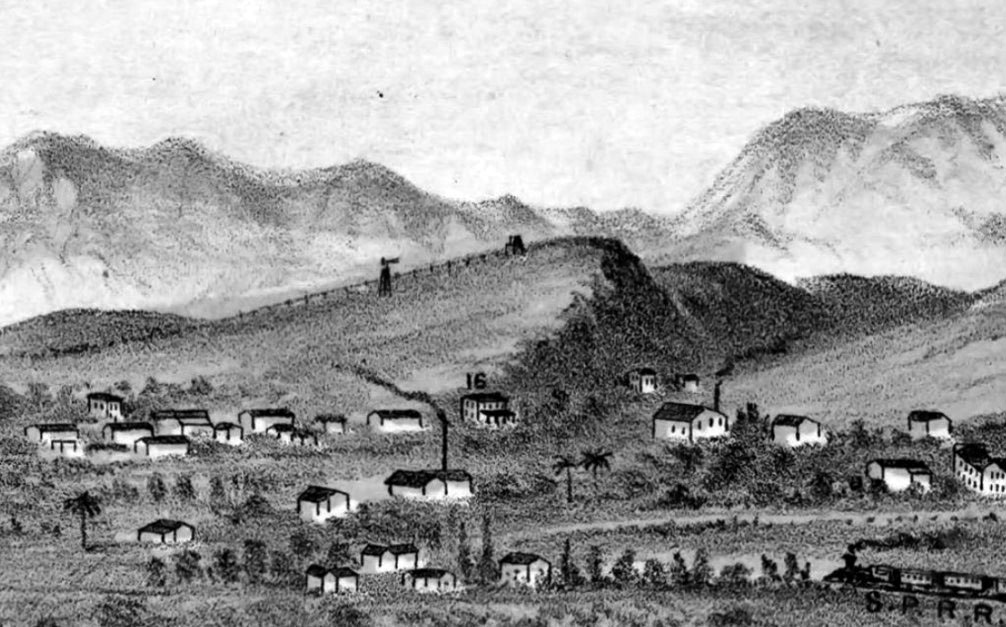
| (1877)* - Detail of E.S. Glover’s View of Los Angeles from the East showing what was to become Victor Heights. |
Historical Notes Canadian brothers Prudent and Victor Beaudry first increased their fortunes (having been born wealthy) in Northern California with a variety of business pursuits before moving to Los Angeles where Prudent entered politics (from 1874 to 1876 he served as Los Angeles’s thirteenth mayor). Victor mined, developed water works, and worked in real estate before moving to Los Angeles in 1855. He and his mining partner (and fellow Quebecois) Damien Marchessault built an ice house in Los Angeles in 1859 — the year Marchessault became mayor — and sold ice to saloon keepers and others. In the 1860s, the Beaudrys bought land in and around the French Town section — an historic neighborhood centered around Alameda and Aliso streets whose existence today is mainly seen in street names like Bauchet, Ducommun, and Vignes. Beaudry went on to increase his fortunes in silver mines and simultaneously earned the nickname the “water king” as he developed water transportation systems for both mines and in town. After the mines began to prove less profitable, Victor moved to Montreal in 1876 where he married Angelica Le Blanc. The couple and their family moved back to Los Angeles in 1881 where he remained until 1886. In Los Angeles, the Beaudry brothers built a water reservoir in the Elysian Hills and used it to hydrate their properties there including Bunker Hill (subdivided in 1876), and what would become Angeleno Heights and Victor Heights. To make their properties more appealing to potential homebuyers, the Beaudrys created two parks, Bellevue Terrace and Beaudry Park. Beaudry Park was a 7.4 acre oval property designed by landscape architect/gardener Francis Tamiet and included many Mexican limes, gums, cypresses, oranges, and Monterey pines.* Ultimately, the Beaudrys placed their two gardens on the market soon after they liquidated the surrounding real estate tracts. In 1881 the state purchased Bellevue Terrace for the site of the California Branch State Normal School, a teaching college that eventually became UCLA. When the Los Angeles Central Library replaced the college in 1926, construction crews graded the hill out of existence. Beaudry's Park, meanwhile, was purchased in 1883 by the Sisters of Charity. On that site (now occupied by The Elysian apartment building and Holy Hill Community Church) the sisters placed their new infirmary, repurposing Beaudry's fruit trees and cypresses into a soothing backdrop for their patients. |
 |
|
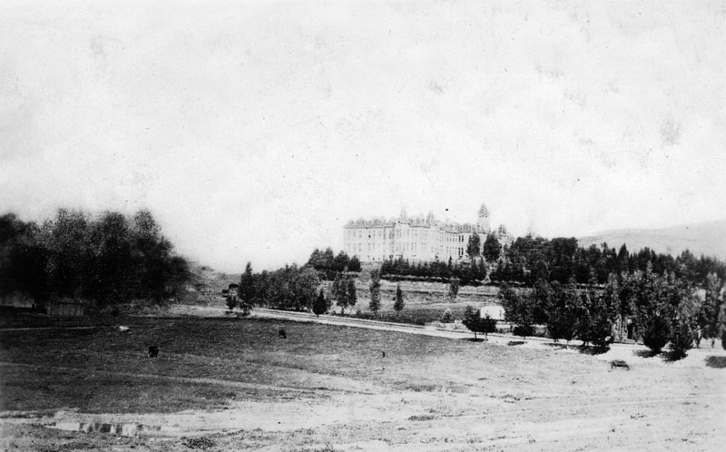
| (ca. 1887)* - View looking northwest showing St. Vincent's Infirmary (aka Sisters Hospital) located near Sunset Blvd and Beaudry Ave as seen from across a sparse field. Several trees can be seen to the right of the grand hospital, which boasts of numerous windows, dormers, an irregular roof, a cupola or tower, and several chimneys. |
Historical Notes In 1883 the Daughters of Charity of St. Vincent de Paul purchased six and a half acres of land at Beaudry Park at a cost of $10,000, and a new hospital building was erected a year later near Beaudry and Sunset, on a hillside overlooking Sonora Town. By 1898, Los Angeles Infirmary had come to be known as Sisters Hospital, but both names were used interchangeably in reference to the same hospital. |
 |
|
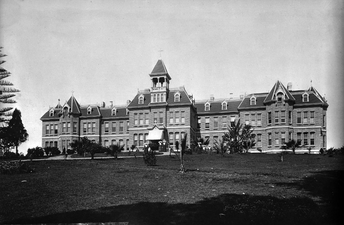
| (ca. 1887)* - Photograph of St. Vincent's Infirmary (aka Sisters Hospital) as seen from across the lawn. Several trees, most of them palms, are planted in front of the grand hospital that shows numerous windows, dormers, an irregular roof, a cupola or tower, and several chimneys. Six nuns can be seen walking and/or sitting around the front lawn. |
Historical Notes The Daughters of Charity of St. Vincent de Paul established the first hospital in Los Angeles - the Los Angeles Infirmary, in 1856. It was located in the Sonora Town adobe owned by then-Mayor of Los Angeles, Don Cristo´bal Aguilar. Four years later, in 1860, the hospital relocated to 1416 Naud Street, between Ann (named for Sister Ann) and Sotillo Street (though other data indicates the location was 1414 Naud Street, between N. Main and San Fernando Road). In 1869, Daughters incorporated the Los Angeles Infirmary under their own ownership, the first women in the region to do so. In 1883 they purchased six and a half acres of land at Beaudry Park at a cost of $10,000, and a new hospital building was erected a year later at Beaudry and Sunset, on a hillside overlooking Sonora Town. By 1898, Los Angeles Infirmary had come to be known as Sisters Hospital, but both names were used interchangeably in reference to the same hospital; in 1918, the name was officially changed to St. Vincent's Hospital. In 1924 a new building was erected on 3rd and Alvarado, which was built by John C. Austin and Frederick M. Ashley. For 47 years, the hospital had such a steady growth that they were forced to expand yet again, and groundbreaking for a newer, larger building took place in 1971 - this time, located at 2131 W. 3rd Street. With a "new" hospital came a new name, and in 1974, it changed again, this time becoming St. Vincent Medical Center. |
 |
|
| (1909)* - Detail of Worthington Gates’s birdseye map of Los Angeles, showing Victor Heights. The Sisters Hospital is seen at lower center-left at Sunset and Beaudry. |
Historical Notes Beaudry Park was located near the intersection of Beaudry Ave. and Sunset Blvd. When acquired for a hospital by the Daughters of Charity of St. Vincent de Paul, the park was an oval-shaped parcel of open land. Sisters Hospital (originally St. Vincent's Infirmary) was built in 1884 on six and half acres of what was then known as Beuadry Park (developed by brothers Prudent and Victor Beaudry in 1876). |
 |
|
| (2010s)* - Pendersleigh & Sons Cartography‘s Map of Victor Heights. Photo Courtesy of Eric Brightwell |
Historical Notes In Victor Heights the most visible reminder of the neighborhood’s once strongly-Italian character is Eastside Market and Deli. It was opened in the 1920s by Puglia-born Domenic Pontrelli across the river in the Eastside (Lincoln Heights) before moving to its current location (1013 Alpine Street) in 1929. Back then Alpine Street was home to three other Italian Markets. It was from within Eastside Deli that Pontrelli’s son-in-law launched Pontrelli & Laricchia Sausage Company which moved out of the neighborhood in 1973. Shortly after, a former clean-up boy for the sausage company, Johnny Angiuli, took over the market with his brother, a former delivery driver, and they reorganized the establishment around a new deli counter, which is its focus today Located within the Victor Heights is the Art Deco-style Navy and Marine Corps Reserve Center Building, designed to be the largest enclosed structure without walls in the world by architects Robert Clements and Associates. It was constructed by the WPA between 1938 and 1941 as one of the country’s largest naval armories, its secluded location chosen to shield it in the event of an air attack. During World War II, more than 20,000 sailors passed through the training center. In 1980, an electrical fire heavily damaged the interior, which reopened in 1986 after a renovation. It was designated California State Historic Landmark #972 in 1989. The military left in 1995 and it’s now home to the LAFD’s Frank Hotchkin Memorial Training Center, named after the firefighter who died fighting the 1980 conflagration. Also located within the area is the Metropolitan Water District Headquarters complex, situated at 1111 Sunset Boulevard on a site that was formerly Beaudry Park and later St. Vincent's Hospital. |
MWD Headquarters
 |
|
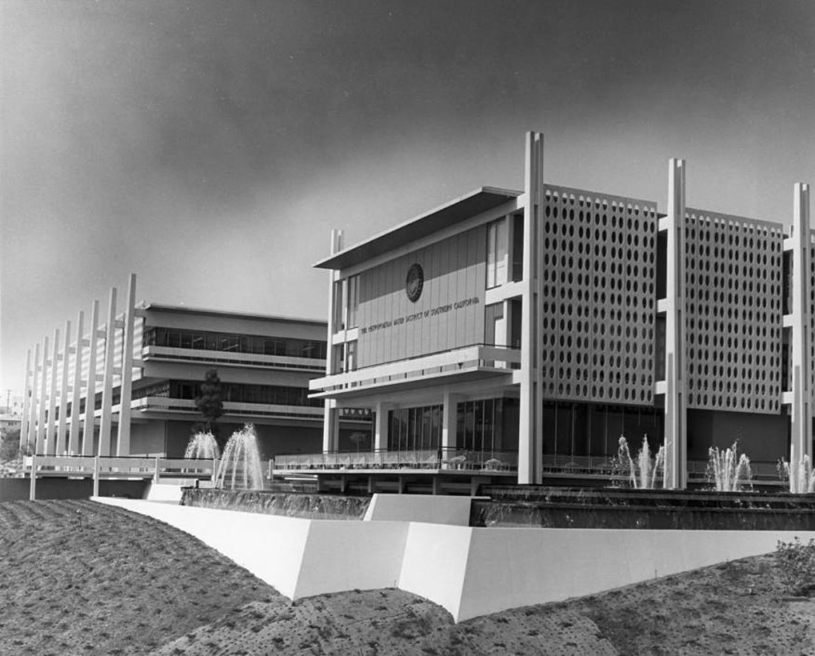
| (1961)* - Architects rendering of the Metropolitan Water District Headquarters complex to be located at 1111 Sunset Boulevard. |
Historical Notes The Metropolitan Water District (MWD) Headquarters on Sunset Boulevard in Los Angeles has a significant history dating back to the early 1960s. Designed by renowned architect William Pereira, the complex was constructed between 1961 and 1963 on a 7-acre oval-shaped hillside lot. The site, formerly Beaudry Park and later St. Vincent's Hospital, was strategically chosen for its prominent location along Sunset Boulevard. |
 |
|
| (1963)* - View showing the Metropolitan Water District campus designed by William L. Pereira. |
Historical Notes The original MWD campus featured three long, low-rise buildings with distinctive architectural elements, including perforated screens of cast stone, exposed "out-rigger" columns, and wide expanses of glass. This design reflected the modernist aesthetic of the era and symbolized the growing importance of water management in Southern California's development. In 1971, an eight-story office tower was added to the northwest end of the campus, expanding its capacity. |
 |
|
| (1963)* - Photo of the Metropolitan Water District complex, designed by William Pereira & Associates. Photo courtesy of Metropolitan Water District. |
Historical Notes The MWD Headquarters served as the agency's operational hub until 1997, playing a pivotal role in advancing water management across Southern California. During this period, the MWD emerged as a global leader in water resources management, conservation, and reclamation. The building's design and prominent location symbolized the vital role of water in the region's growth and development. After the MWD moved to a new headquarters near Los Angeles Union Station in 1997, the Sunset Boulevard campus was sold to a Korean-based church. In recent years, plans have emerged to redevelop the site into a mixed-use project named 1111 Sunset Boulevard. These proposals aim to revitalize the long-vacant property while preserving aspects of its original architectural character. |
Downtown's Changing Skyline from Victor Heights
 |
|
| (1963)*- View from the balcony of the MWD headquarters at 1111 Sunset Boulevard, looking toward Bunker Hill. The DWP Building and Dorothy Chandler Pavilion are visible under construction. Photo by Julius Shulman. |
Historical Notes The Metropolitan Water District Headquarters building at 1111 Sunset Boulevard was designed by the architectural firm William L. Pereira & Associates in 1961. The building featured a modern architectural style characteristic of the early 1960s. The headquarters was a significant structure, serving as the main office for the Metropolitan Water District, which provides water to 92 incorporated cities and large unincorporated areas in Southern California. The building's design included a prominent facade and was situated at the intersection of Sunset Boulevard and Beaudry Avenue. |
 |
|
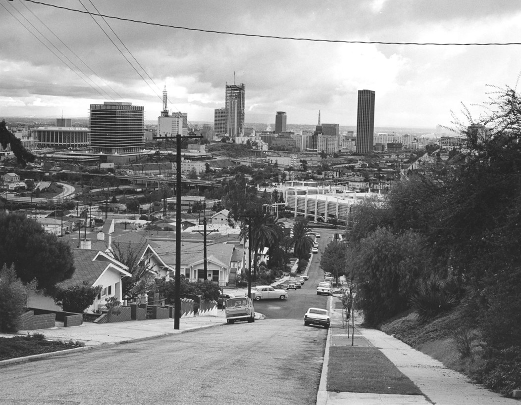
| (1967)* - View from the top of White Knoll Drive looking south toward Figueroa Terrace. In the distance can be seen the Four-Level Interchange, the 1965-built Water and Power Building and Dorothy Chandler Pavilion, and only a few skyscrapers. Photo by William Reagh |
Historical Notes At the bottom of White Knoll Drive can be seen the MWD headquarters building at 1111 Sunset Boulevard. It was built in the early 1960s, designed by William Pereira, with an additional tower added in 1974. The MWD occupied this campus from 1963 until relocating downtown in 1993. |
 |
|
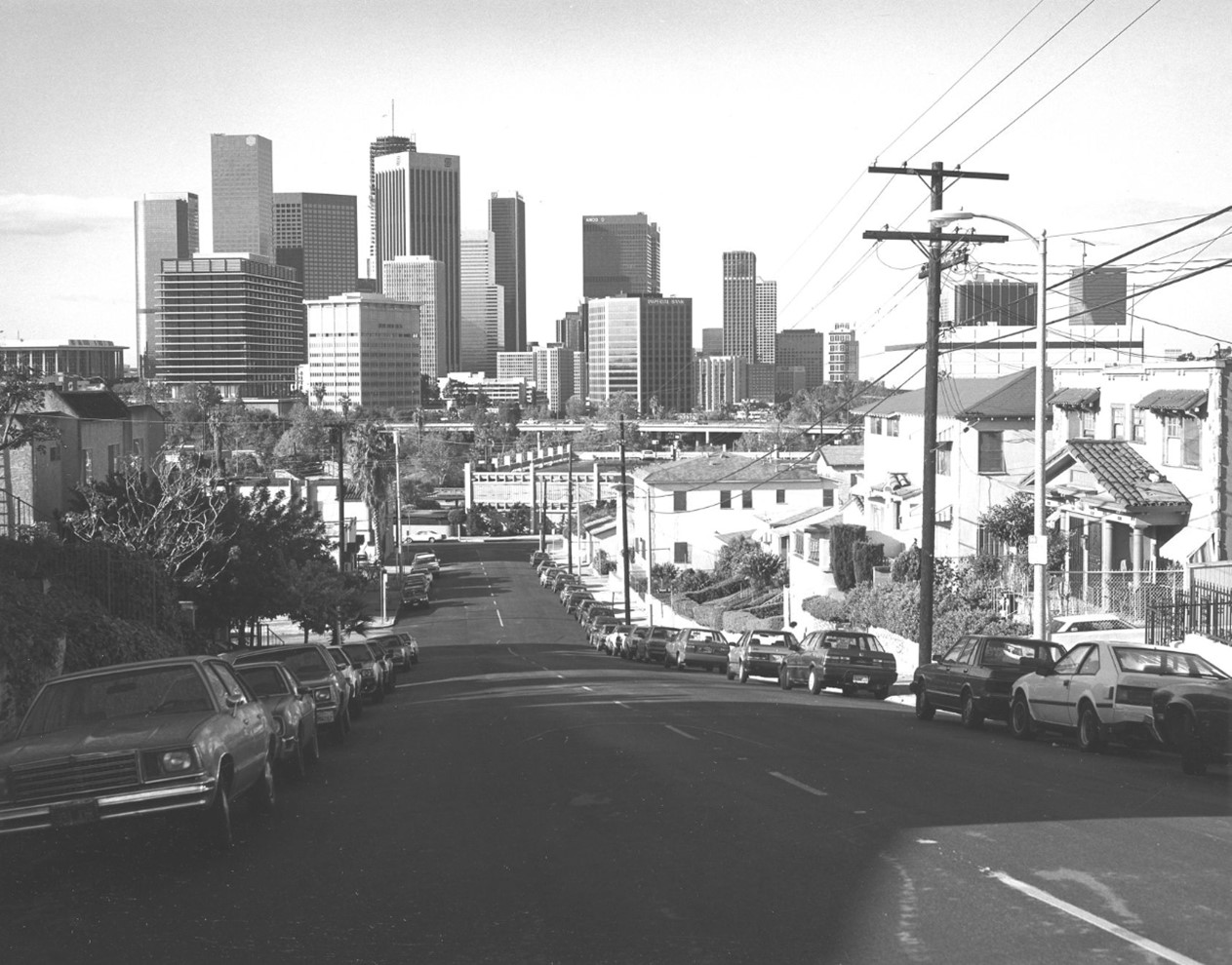
| (1980)* - View from the top of White Knoll Drive looking south toward Figueroa Terrace. Photo by William Reagh |
Historical Notes The downtown Los Angeles skyline in the 1980s was marked by a dynamic blend of modern skyscrapers and historic buildings, reflecting the city's rapid growth and architectural evolution. Notable structures like the Library Tower (now U.S. Bank Tower), completed in 1989, emerged as dominant features, becoming the tallest building in Los Angeles at 73 stories. This decade witnessed a shift towards high-rise construction as earlier height restrictions were lifted, allowing for iconic skyscrapers such as the Bank of America Plaza to reshape the skyline. The architectural styles of the era varied from postmodern designs to sleek glass facades, mirroring broader urban development trends. Additionally, significant urban renewal projects, particularly around Bunker Hill, transformed the area into a cultural and civic hub, paving the way for theaters, museums, and residential complexes. Overall, the 1980s were a transformative period that set the stage for the contemporary identity of downtown Los Angeles |
 |
|
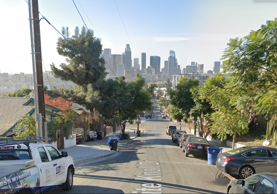
| (2020)* - View from the top of White Knoll Drive looking south toward Figueroa Terrace. |
Historical Notes Looking at the end of White Knoll Drive you can see an eight-story office tower which was added to the MWD campus in 1974. The MWD occupied the site starting in 1963 until 1993 when it moved its headquarters to a new location downtown. |
 |
|
| (2014)* - View showing the eight-story tower, which was part of the original Metropolitan Water District (MWD) campus, converted into an apartment complex known as The Elysian. Photo by Gary Leonard. |
Historical Notes The Elysian, located on Sunset Boulevard in Los Angeles, is a luxury apartment building that was formerly the Metropolitan Water District (MWD) headquarters. Designed by the renowned modernist architect William Pereira and completed in 1963, the original MWD complex featured a distinctive low-rise building and a tower. After the MWD relocated in 1993, the property changed hands several times before being acquired by Linear City Development in 2011, which led to its transformation into The Elysian. |
Then and Now
 |
|
| (1967 vs 2020)* - View from the top of White Knoll Drive looking south toward Figueroa Terrace. |
Then and Now
 |
|
| (1967 vs. 2019) – The changing downtown skyline as seen from Victor Heights. View is from the top of White Knoll Drive looking south toward Figueroa Terrace. Contemporary photo by Jack Feldman |
.jpg) |
|
| (2019) - View looking at the Los Angeles skyline as seen from Marview Ave and Figueroa Terrace in Victor Heights. Photo by Jack Feldman |
Legacy of Victor Beaudry Victor Heights is named after Victor Beaudry as well as Victor Street, a short two block span between Temple Street and Bellevue Ave that is bisected by the 101 Freeway. |
 |
|
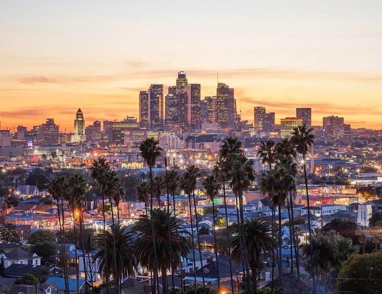
| (2019)* – Night view of Downtown LA and Victor Heights as seen from the hills of Echo Park. Photo courtesy of Al Medrano |
 |
|
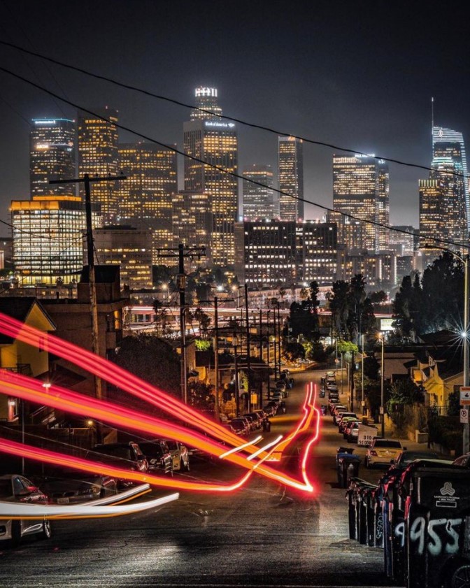
| (2020)* - Time lapse night view showing the Downtown Skyline as seen from 955 N. Beaudry Avenue, Victor Heights. Photo by Nate Walker |
* * * * * |
Historical Early Views
Newest Additions
Early LA Buildings and City Views
History of Water and Electricity in Los Angeles
* * * * * |
References and Credits
* LA Public Library Image Archive
^ California Fool’s Gold - Exploring Victor Heights
^*KCET: Bellevue Terrace and Beaudry Park: L.A.'s Two Lost Hilltop
< Back