Smog in Early Los Angeles: From Crisis to Control
In the early twentieth century, Los Angeles grew faster than almost any city in the country. New industries, millions of cars, and a warm climate helped drive that growth, but they also created a serious air pollution problem. Smog became a daily part of life, often burning eyes, limiting visibility, and affecting health across the region. Because the city sits in a natural basin, polluted air was trapped and slow to clear. The photographs in this section show how smog shaped everyday life in Los Angeles, how scientists and public officials struggled to understand its causes, and how decades of research, regulation, and public pressure eventually led to cleaner air. |
 |
|
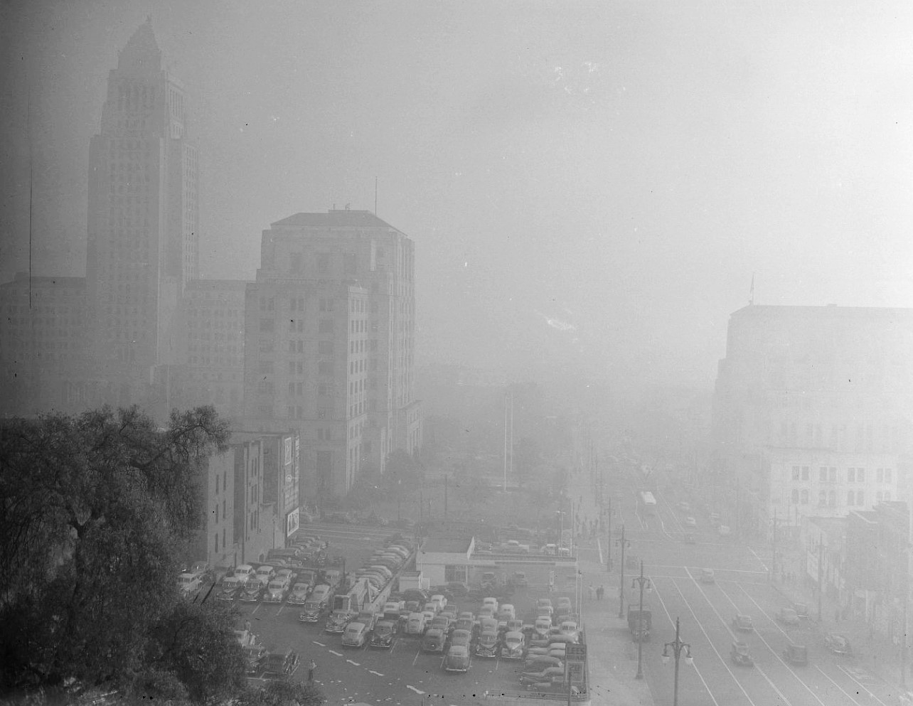
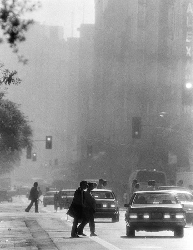
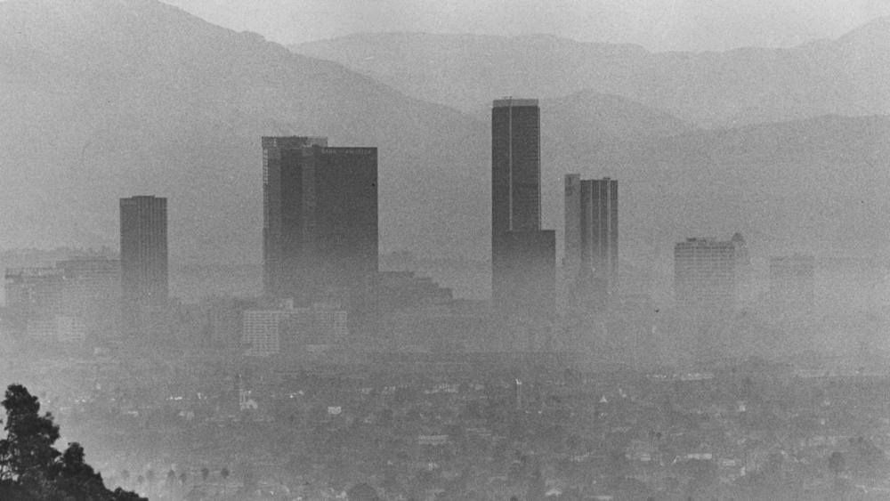
| (1948)* - L.A. Civic Center masked by smog. Courtesy of UCLA Library Special Collections - Los Angeles Times Photographic Archive. |
| Historical Notes
By the late 1940s, the Civic Center was often swallowed by haze even in the middle of the day. People who worked downtown learned to expect stinging eyes and scratchy throats on bad mornings, and many kept windows shut even in warm weather. Smog also changed daily routines because it reduced visibility for driving and made outdoor breaks and errands uncomfortable. |
.png.jpg) |
|
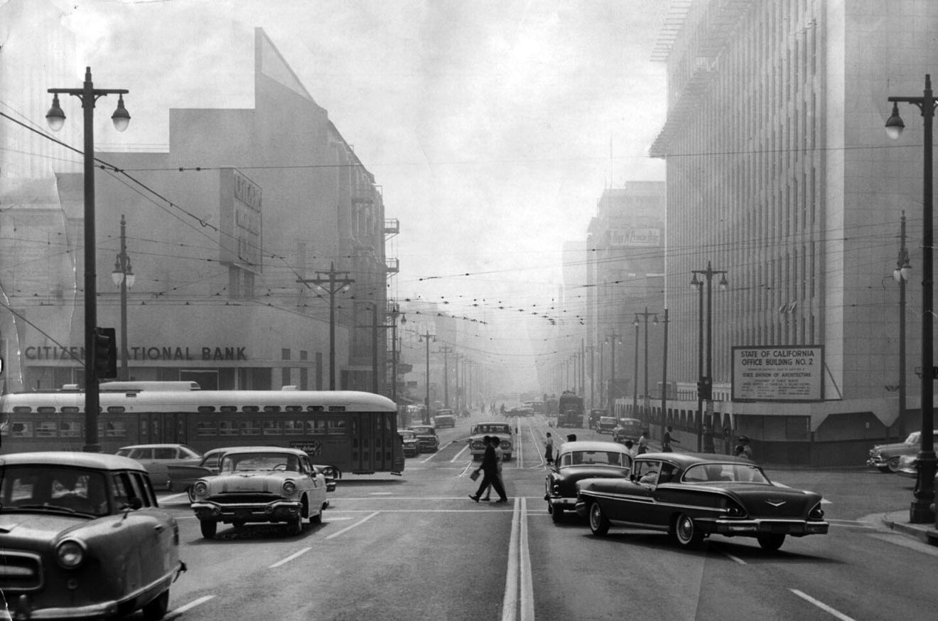
| (1946)* – View looking east on 1st Street at Broadway showing a smoggy day in downtown Los Angeles. |
| Historical Notes
Smog was not limited to the later freeway age. Downtown workers, shoppers, and streetcar riders already dealt with dirty air that made the streets feel dim and heavy. On hazy days, people complained about headaches, burning eyes, and a sour chemical smell, and shop owners worried that fewer pedestrians would linger outside. Los Angeles experienced smog well before the postwar population boom. As early as 1903, smoke and industrial fumes were so dense that residents mistook a midday event for an eclipse. Between 1905 and 1912, the City Council passed several early anti-smoke ordinances, but they were no match for the massive urban and industrial expansion that followed. By the 1940s, downtown streets like 1st and Broadway often sat beneath a gray-brown canopy of pollutants. |
 |
|
| (1951)* - View of the State Building and LA Times Building as seen from City Hall on a smoggy day. |
| Historical Notes
From City Hall, the short distance across downtown could disappear into a brown gray veil. For many Angelenos, that loss of visibility became a daily reminder that the problem was not just smoke, it was something trapped in the air they breathed. People began to plan around it, choosing indoor activities, limiting outdoor exercise, and checking the sky the way others check the weather. |
 |
|
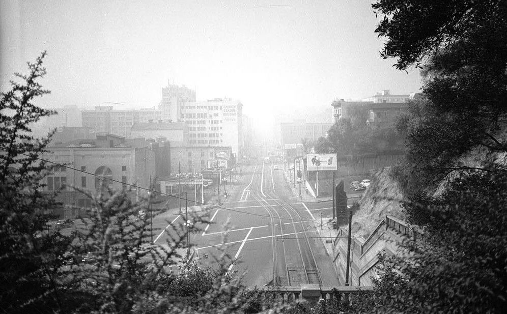
| (1949)* - Standing above the old Hill Street Tunnel on a smoggy morning, looking south down Hill Street from 1st. This shot is in the Examiner Collection at USC with the caption “Beautiful Los Angeles Smog.” |
| Historical Notes
The joking caption shows how people tried to laugh at something that was getting worse. But the humor also covers a harder truth: commuting and walking downtown could mean watering eyes and tight lungs, day after day. By this point, smog was no longer an occasional nuisance, it was becoming part of the city’s normal look and feel. |
 |
|
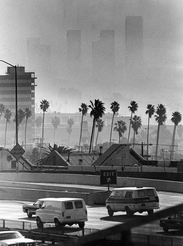
| (1940)* - BEFORE SMOG CHECKS - Three cars are seen here heading east on Hollywood Boulevard with smoke billowing out of their tailpipes. |
| Historical Notes
Before any meaningful emissions regulations, scenes like this were common across Los Angeles. Cars belched visible smoke, and there were no smog checks to limit pollution. California wouldn’t launch its first vehicle emissions testing program until 1984, decades after photos like this made the problem painfully obvious. |
 |
|
| (1940s)* – Driving into Downtown Los Angeles on a smoggy day. |
| Historical Notes
By the 1940s, driving into downtown meant breathing polluted air from the moment commuters entered the basin. Wartime growth and car dependence made daily travel a major source of exposure. For many residents, smog was no longer something seen from afar, it was something inhaled every workday. |
 |
|
| (1940s)* - A woman is seen wiping her eyes as smog blankets Downtown Los Angeles. |
| Historical Notes
After one of the first major smog events in 1943, city officials wrongly blamed the Southern California Gas Company’s Aliso Street plant, which was producing butadiene, a chemical used in synthetic rubber. Although the plant was temporarily shut down due to public pressure, the smog only worsened. Mayor Fletcher Bowron declared the problem would be solved within four months—an optimistic prediction that proved far from accurate. |
.jpg) |
|
| (1955)* - Buildings in Los Angeles Civic Center are barely visible in picture looking east at 1st and Olive Streets when smog was at its peak. Photo by John Malmin / Los Angeles Times |
| Historical Notes
This photo, taken at 1st and Olive Streets, shows buildings nearly disappearing into a wall of smog. In the early 1950s, Caltech chemist Arie Haagen-Smit solved the mystery of L.A.'s smog by identifying ozone as its main component. He demonstrated that ozone formed when sunlight interacted with unburned car exhaust and hydrocarbons from refineries. His research explained not only the hazy skies, but also the bleach-like odor, eye irritation, and health issues plaguing the city. |
 |
|
| (1953)* – Looking SW toward City Hall from the site of the Aliso Street Project of the Santa Ana Freeway through downtown. Also seen here (L to R): Taix French Restaurant, Old Hall of Records, and the Federal Courthouse and U.S. Post Office Building. |
| Historical Notes
From the site of the Santa Ana Freeway construction, this view southwest toward City Hall shows downtown in transition—both physically and environmentally. Despite freeway expansion promising greater mobility, it also meant more cars, more emissions, and worsening smog in the city’s core. |
 |
|
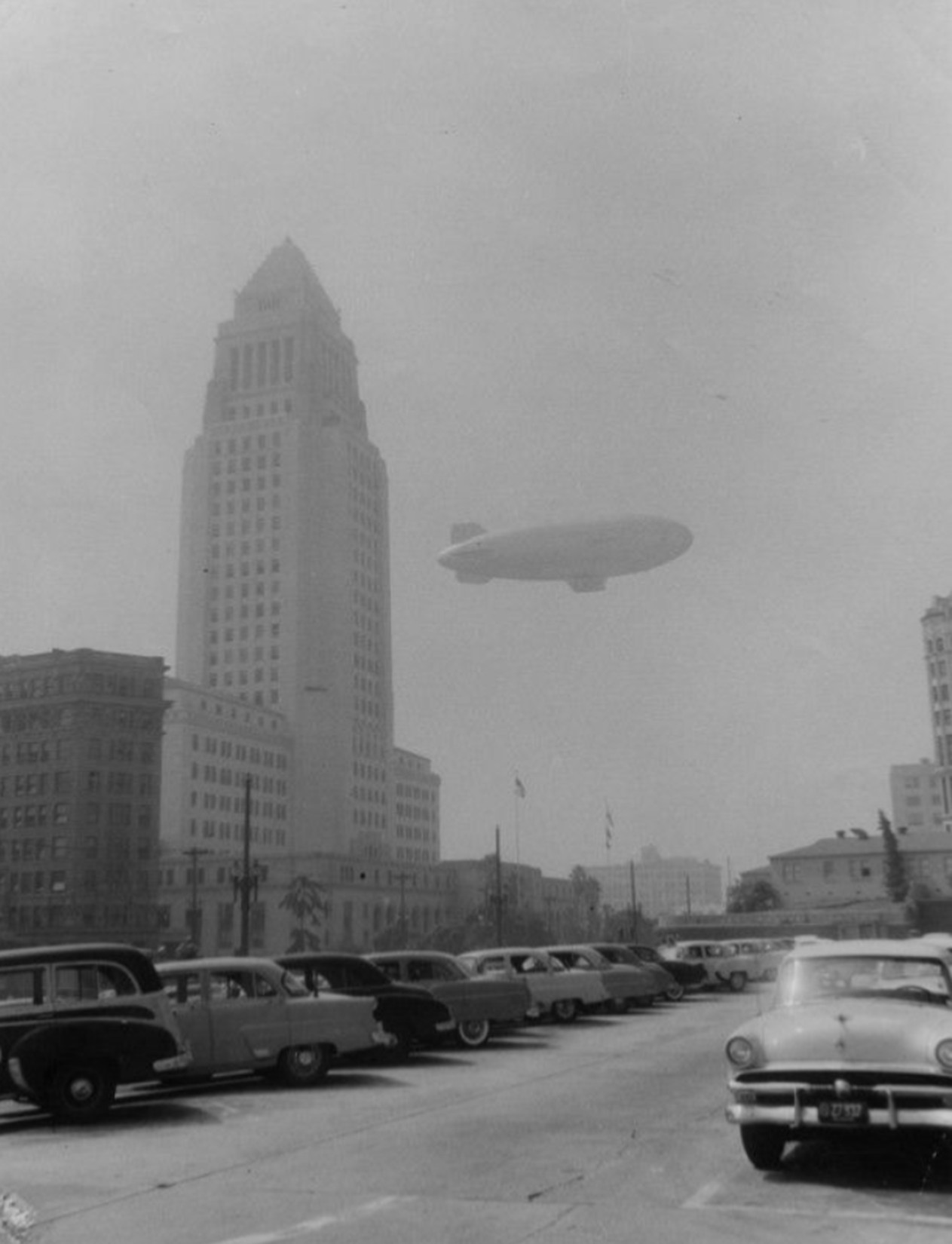
| (1954)* – Blimp flying over downtown Los Angeles on a smoggy day. Buildings seen (L to R): Federal Courthouse and U.S. Post Office Building, International Bank Building, and City Hall. |
| Historical Notes
On September 9, 1954, a Navy blimp hovered over downtown Los Angeles to collect air samples at multiple altitudes—500 feet, 1,000 feet, and the top of the smog layer. The mission was part of early scientific efforts to better understand what made L.A.’s air so hazardous, and to support the work of researchers like Haagen-Smit in identifying smog’s chemical composition. |
 |
|
| (1954)* - A hazy look at a Navy blimp, testing air pollution levels, as it travels past City Hall and through the smog surrounding downtown Los Angeles. |
| Historical Notes
By the mid 1950s, city and county officials realized that guessing about smog was no longer enough. Scientific testing became part of public policy, and leaders began to rely on measurements rather than opinion. Flights like this helped show that smog was layered and widespread, which pushed officials toward regional solutions instead of blaming single factories. |
 |
|
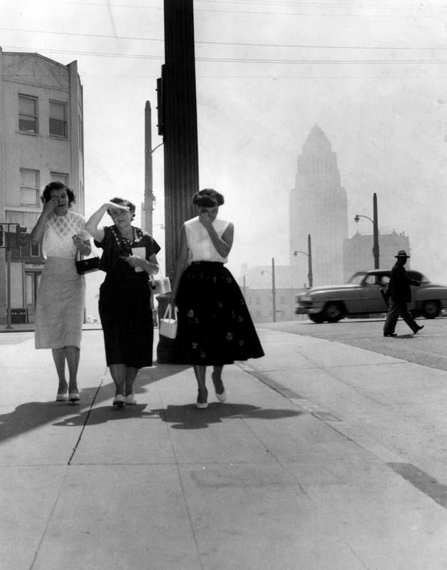
| (1955)* - Three women on a downtown Los Angeles sidewalk are troubled by the eye-irritating smog. City Hall is barely visible in the background. Photograph dated Septmber 14, 1955. |
| Historical Notes
By the mid-1950s, the health effects of L.A.'s smog were impossible to ignore. On bad days, children stayed home from school, athletes avoided outdoor practice, and crops suffered visible damage. Hospitals saw surges in patients with headaches, irritated eyes, and difficulty breathing. In this photo, the visibility is so poor that City Hall can barely be seen through the haze. |
 |
|
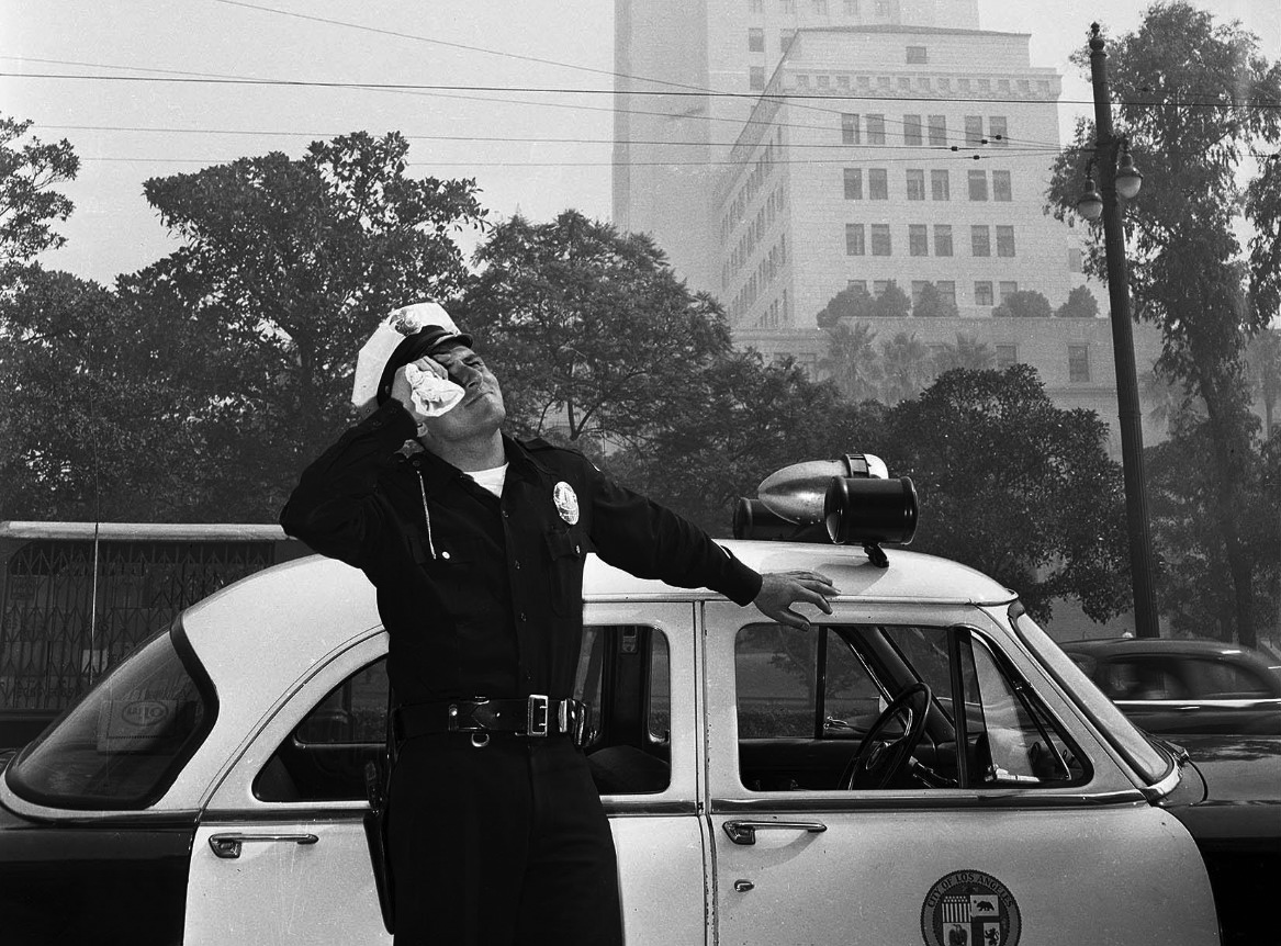
| (1955)* - LAPD officer wiping his eyes due to the smog, with City Hall in the background. |
| Historical Notes
Even law enforcement wasn’t spared the effects of L.A.'s eye-stinging air. This 1955 image of an LAPD officer squinting through the haze captures the day-to-day human toll of smog—something Angelenos endured for decades without relief. |
 |
|
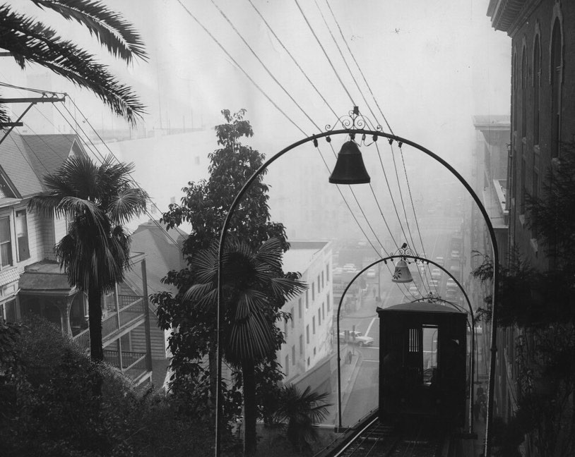
| (1958)* - Photo from LA Times article titled: ‘Blanket of Smog Obscures View of City from Top of Angels Flight’ |
| Historical Notes
From atop Angels Flight, the historic funicular on Bunker Hill, the view of the city should have been sweeping. Instead, this 1958 image—published by the L.A. Times—shows buildings nearly lost in the thick smog that regularly obscured the city’s skyline. |
 |
|
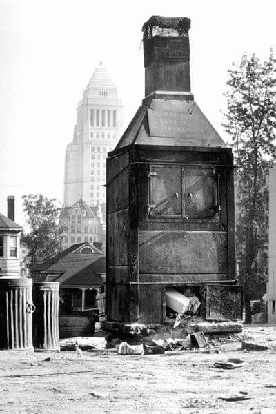
| (1950)* - A very large backyard incinerator located on Bunker Hill with City Hall in the background. |
| Historical Notes
Before curbside trash pickup and centralized waste management, Angelenos burned much of their household waste in backyard incinerators. This oversized unit on Bunker Hill, with City Hall in the background, reflects how common open burning was—and how it contributed significantly to the city’s worsening air pollution. |
 |
|
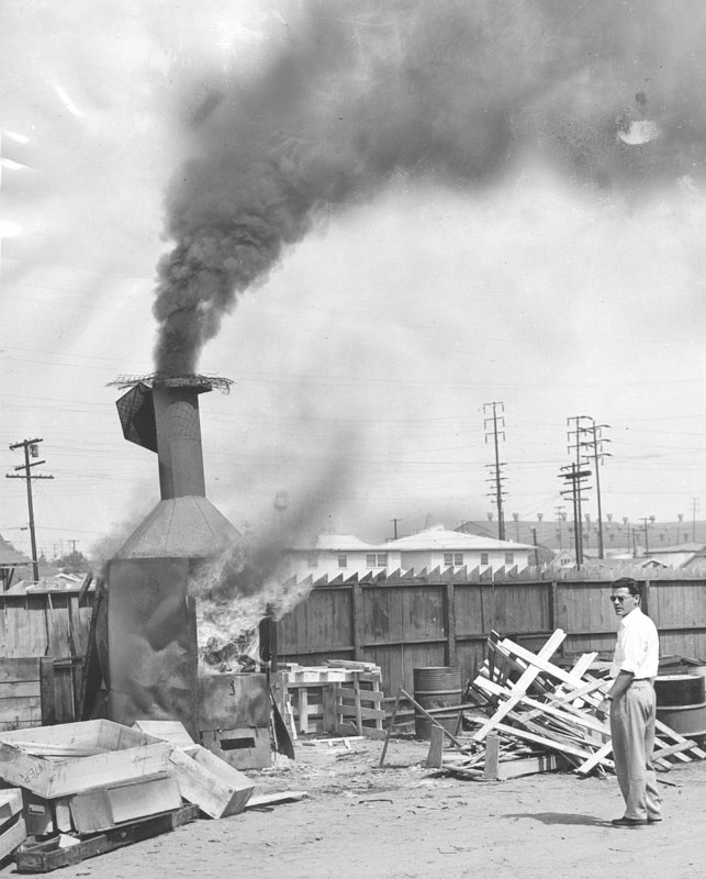
| (1957)* - Outdoor view of a residential incinerator burning trash. Photo dated July 1, 1957. |
| Historical Notes
Backyard incinerators like this one were used daily across Los Angeles neighborhoods. Although they were convenient for waste disposal, they sent smoke and ash into the air—adding to the already dangerous mix of vehicle and industrial emissions. |
 |
|
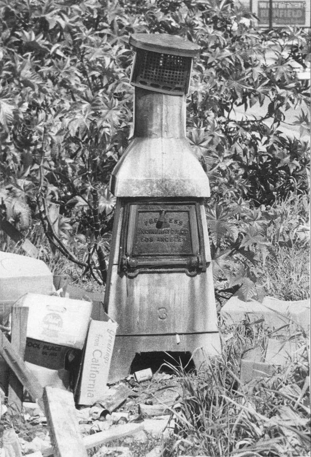
| (ca. 1950s)* - Everyone had one of these in their backyard. |
| Historical Notes
By the mid-1950s, nearly every home had a backyard incinerator. That changed on October 1, 1957, when the Air Pollution Control District’s ban on residential trash burning took effect. It was a major step forward in reducing air pollution and one of the first public policy victories in L.A.'s long battle against smog. |
 |
|
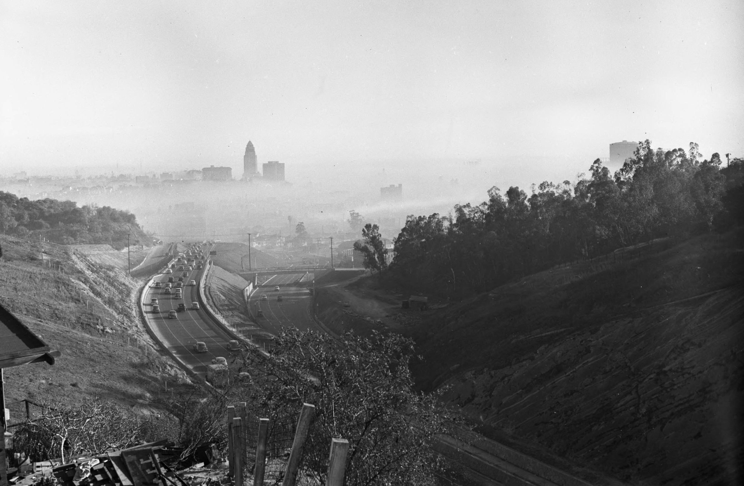
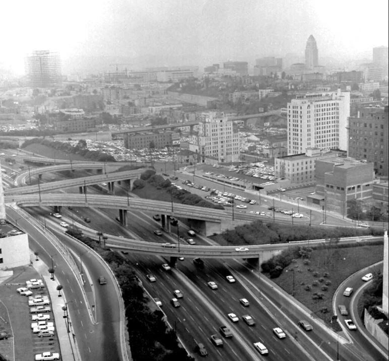
| (1951)* - Heading south on the 101 Freeway near the Four Level Interchange on a smoggy day in downtown Los Angeles. Photo from LIFE Magazine. |
| Historical Notes
In addition to incinerators, Los Angeles' severe smog problem in the early 1950s was caused by several factors: rapid population growth and industrialization after World War II, a doubling of automobiles between 1940 and 1950, geographic and weather conditions that trapped pollutants, and the lack of emissions controls on vehicles and industries. |
 |
|
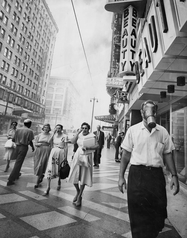
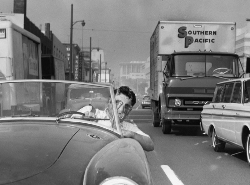
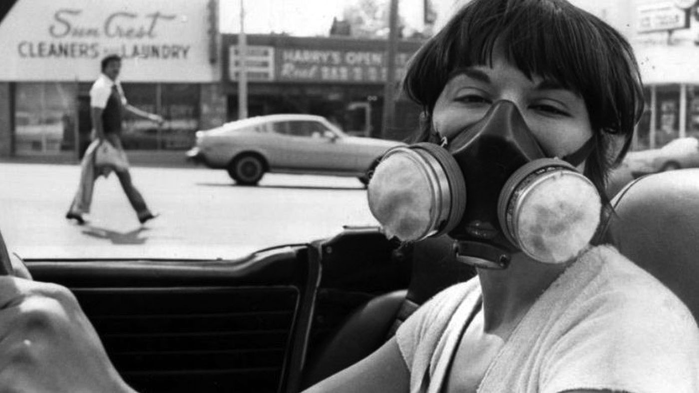
| (1958)* – Photo caption reads: “Man at right defies convention and eye-searing pollutant as he strolls down Broadway wearing a gas mask, as Los Angeles battles another smog attack. Women on left suffer and use their handkerchiefs to wipe away their tears.” Photo dated: September 19, 1958. |
| Historical Notes
By the mid 1950s there was no doubt among scientists that cars were a primary factor in LA’s smog crisis. Automakers were slow to respond. They were wary of any change that would add cost to their vehicles. As a result of public pressure, emission regulations would come to pass. But, it would take another two decades for things to change. It wasn’t until 1975 that the U.S. required new cars to have catalytic converters, the key piece of technology that allowed everything to change. ^ |
 |
|
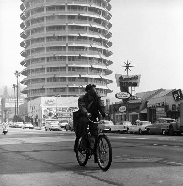
| (1957)^ - Hollywood messenger Edward M. Baker making his rounds wearing a gas mask near the intersection of Hollywood and Vine. In the background can be seen the iconic Capitol Records Building and Dupar’s Restaurant. Photo source: Saturday Evening Post titled: Los Angeles Battles the Murk |
| Historical Notes
Public officials could not ignore scenes like this, which made smog a visible embarrassment for the city. Gas masks became symbols of failure as well as protest. The growing public reaction helped convince lawmakers that voluntary measures were not working and that enforceable rules would be necessary. |
 |
|
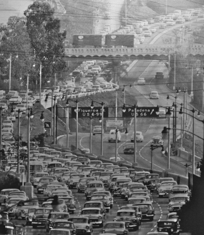
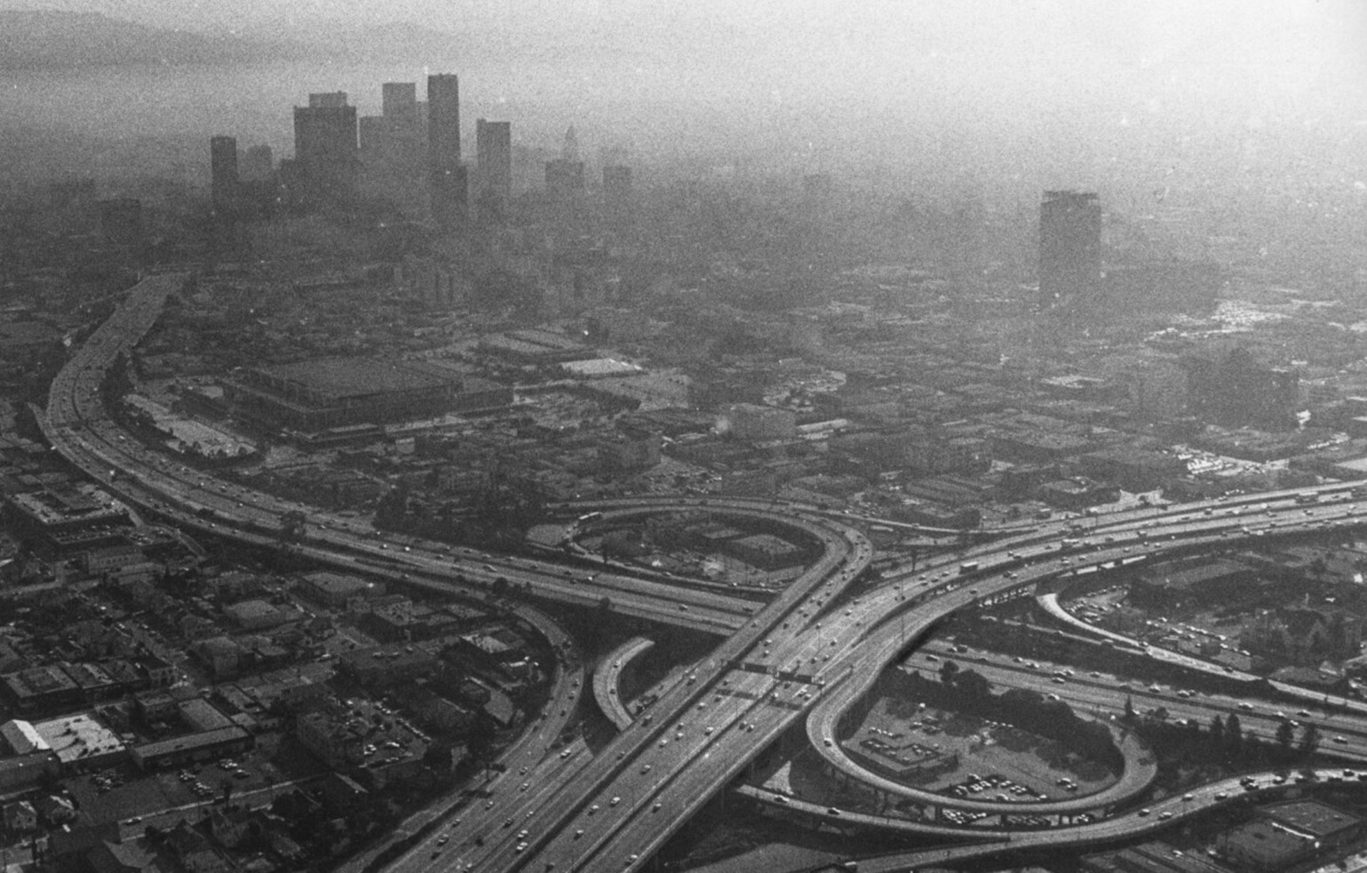
| (1958)* – Smog and traffic congestion on the Pasadena Freeway near Downtown Los Angeles. |
| Historical Notes
Freeways promised speed and convenience, but scenes like this showed the cost. Cars moved slowly while exhaust collected in the air, turning traffic jams into health hazards. The image captures the moment when mobility and pollution collided, exposing the limits of building roads without controlling emissions. |
 |
|
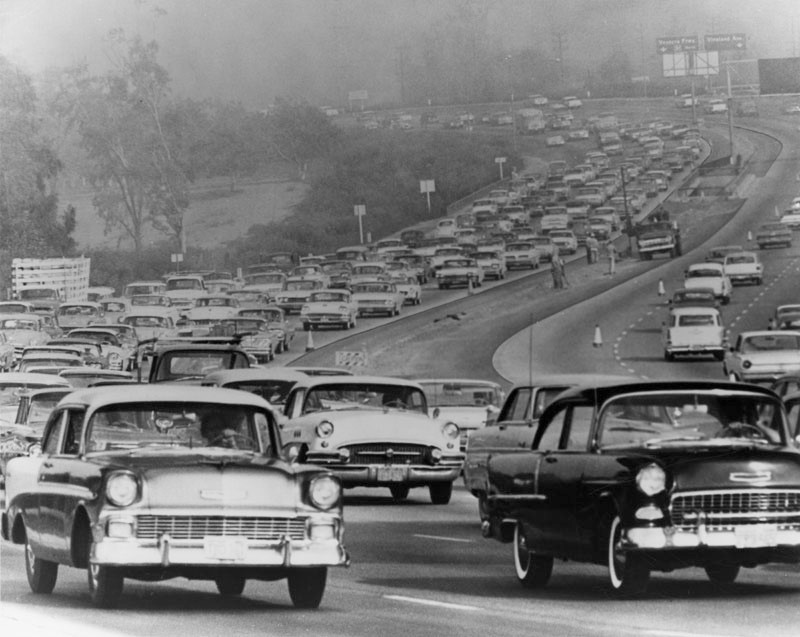
| (1961)* - Traffic congestion and smog on the Hollywood Freeway near the Vineland interchange. |
| Historical Notes
By the early 1960s, commuting meant spending long periods inside polluted air. Stop-and-go traffic trapped drivers in clouds of exhaust, turning routine travel into repeated exposure. Smog became tied to the rhythm of workdays and rush hours. |
 |
|
| (1962)* - An aerial view of Los Angeles on Dec 20 1962, shows the complex of freeways, new construction, familiar landmarks and smog, In the foreground is the Harbor Freeway; just beyond is Bunker Hill where work has begun on the nation's biggest urban redevelopment project; and in the background, barely visible through the smog, is the steel framework of the new Department of Water and Power office building. |
| Historical Notes
From above, smog appeared as a blanket covering the basin, making it clear that no neighborhood was untouched. City leaders increasingly accepted that the problem could not be solved street by street. This realization helped push support for regional air quality agencies with broader authority. |
 |
|
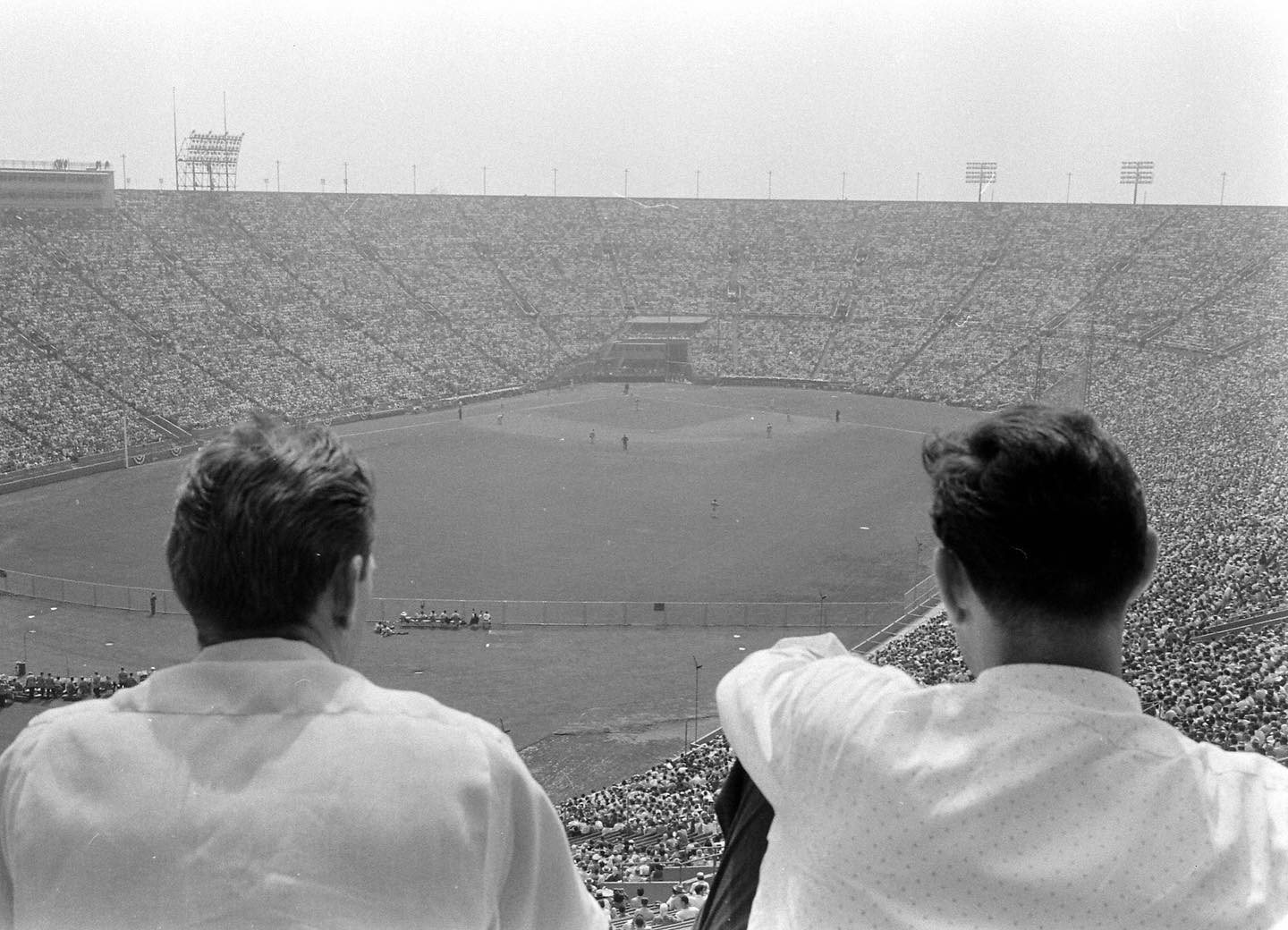
| (ca. 1958)* - Nice afternoon Dodger game at the Coliseum but unfortunately forgot to bring the binoculars and my eye drops. More on Dodgers at the Coliseum HERE. Photo by Allan Grant / LIFE Magazine |
| Historical Notes
Smog did not stop people from gathering, but it changed how they experienced public life. Fans endured burning eyes and hazy views during afternoon games, treating poor air as part of the outing. Humor helped mask the reality that smog reached into moments meant for relaxation. |
 |
|
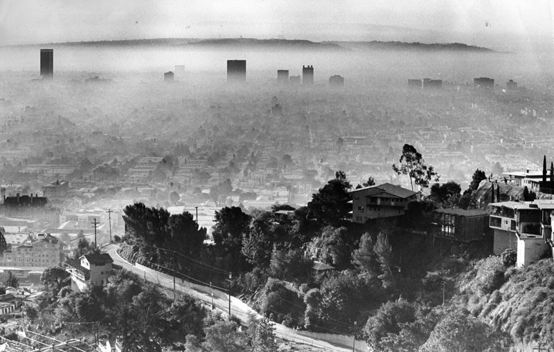
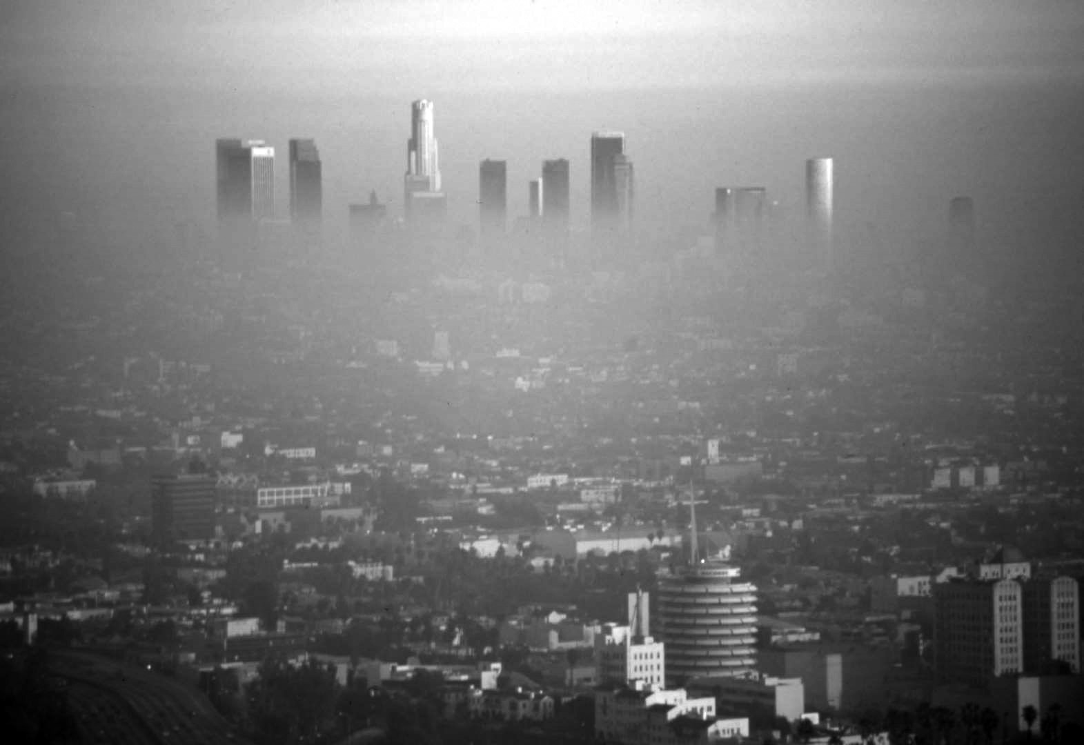
| (1964)* - View looking south as seen from the Hollywood Hills showing the Wilshire corridor at top of photo with Baldwin Hills further back. |
| Historical Notes
On August 22, 1964, Los Angeles basin was recognized as having the worst ozone problem of any city in the U.S.* |
 |
|
| (1958)* - Smog-shrouded view of downtown Los Angeles, looking toward City Hall and the Hall of Justice. |
| Historical Notes
Government buildings that symbolized order and authority often vanished into the haze. The inability to clearly see City Hall from nearby streets reinforced public frustration and helped turn smog from a background annoyance into a civic embarrassment that demanded action. |
 |
|
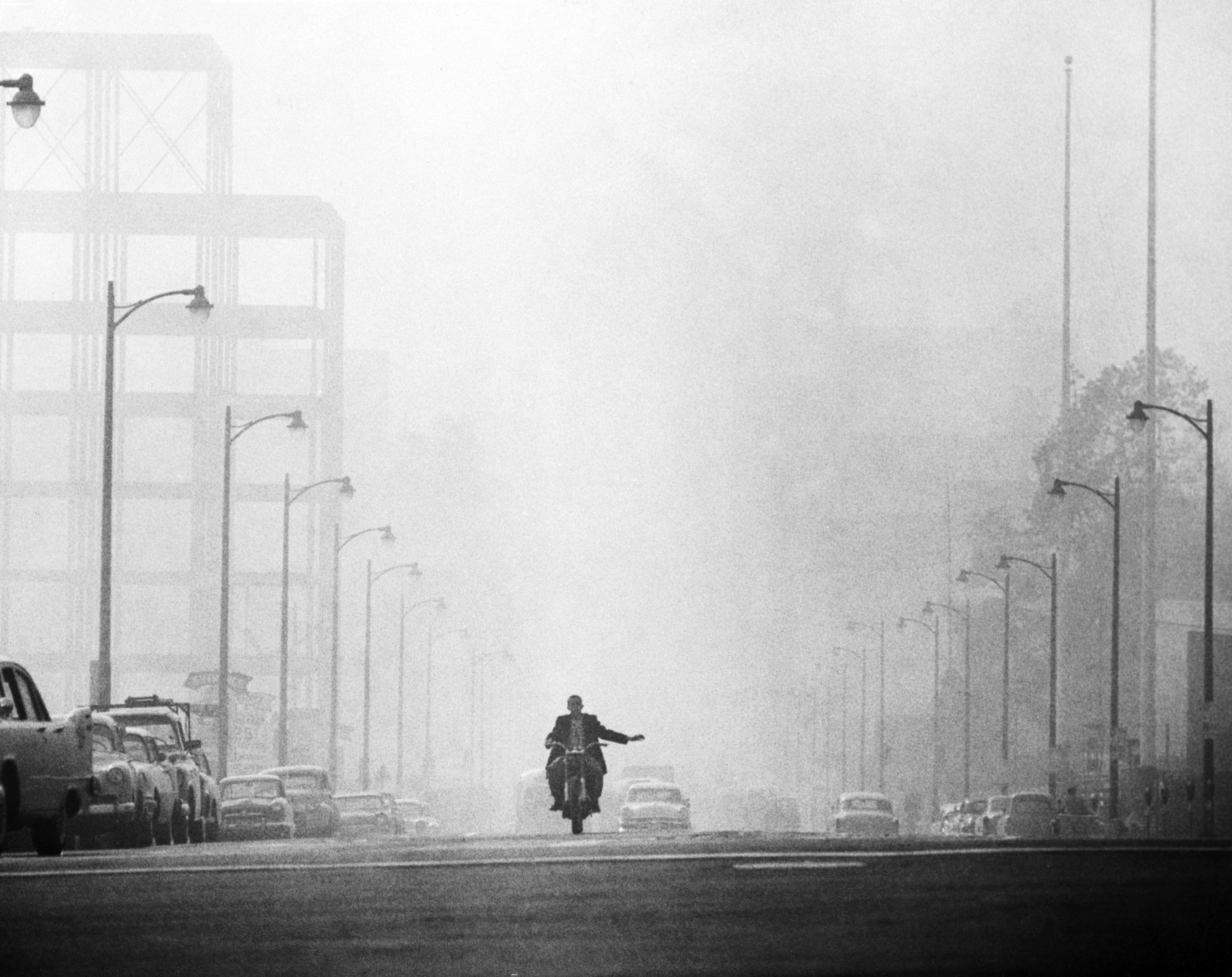
| (1958)^ - A Los Angeles motorcyclist prepares to turn while driving on a street engulfed in a thick haze of smog. |
| Historical Notes
Riders and drivers were among the most exposed to smog. Without enclosed cabins or air filters, motorcyclists breathed polluted air directly, leading to eye irritation, coughing, and fatigue. Scenes like this highlighted the everyday health risks faced by people who relied on the streets for work or transportation. |
 |
|
| (1959)^^ - Smog blankets Los Angeles as seen from First and Broadway looking south. This photo was published on page one of the Nov. 13, 1959 Los Angeles Times. |
| Historical Notes
When smog reached the front page of the Los Angeles Times, it signaled how serious the problem had become. Visibility in the city core could drop to a few blocks, disrupting traffic and daily business. Public pressure intensified as residents saw their city portrayed as unhealthy and unsafe. |
.jpg) |
|
| (1960)* - A smoggy day in Los Angeles. View is looking north on Figueroa Street in downtown Los Angeles. |
Historical Notes By 1960, smog was so common that residents judged the day by how far they could see. Predictions and warnings became part of daily conversation, even when conditions fell short of forecasts. The air itself had become a measure of what kind of day it would be. |
 |
|
| (1966)* – Photo caption reads: “In the smog battle a Los Angeles commuter wears an only slightly satiric gas mask on October 2, 1966. Automotive experts show how a new smog device cuts down on the emission of car fumes, while testifying before the California Assembly.” |
| Historical Notes
By the mid 1960s, public pressure had pushed lawmakers to demand cleaner engines. California leaders began requiring manufacturers to reduce emissions on new vehicles sold in the state. This marked the shift from warnings and studies to laws that directly affected what people drove. |
 |
|
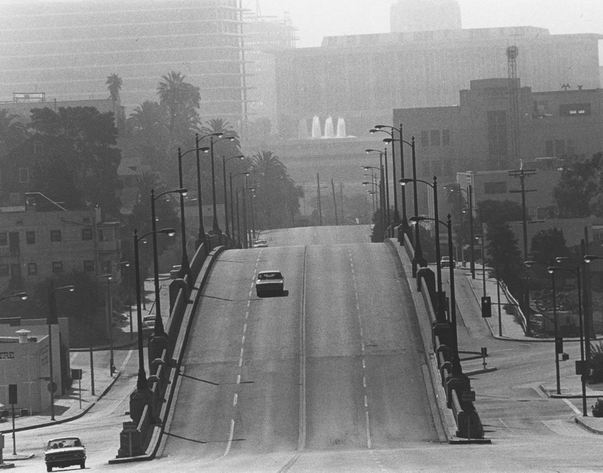
| (1975)* - View looking east on First Street from Belmont High School, just west of Glendale Boulevard. Shows overpass in the foreground; downtown buildings and the DWP fountains in the distance. Photo by William Reagh |
| Historical Notes
It wasn’t until 1975 that the U.S. required new cars to have catalytic converters, the key piece of technology that allowed everything to change. The introduction of catalytic converters drastically reduced tailpipe emission pollutants. Hydrocarbon and nitrogen oxide emissions from new cars plummeted from an average of 14 grams per mile in 1965 to just 3 grams per mile by 1975. This dramatic reduction in vehicle emissions was a major factor in the gradual improvement of air quality in the LA basin over subsequent decades. |
 |
|
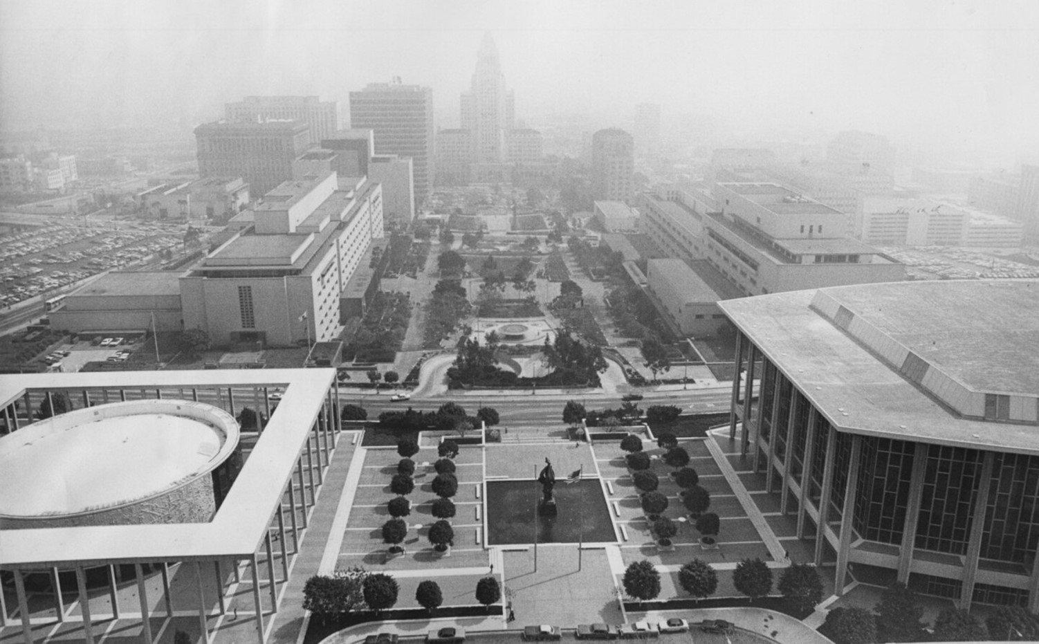
| (ca. 1970)* - Looking across the Civic Center Mall toward a smog-hidden City Hall as seen from the LADWP building. |
| Historical Notes
Persistent smog in the early 1970s showed that local programs were not enough. This period helped drive major changes in environmental law at both the state and national level. City leaders increasingly relied on regional and federal agencies to achieve results they could not accomplish alone. |
 |
|
| (1986)* - View of Spring Street looking south from 3rd Street at 3 p.m. on an unidentified day in November 1986, using infrared film. |
| Historical Notes
Infrared photography revealed pollution that was not always visible to the naked eye. Even when skies appeared clearer than in earlier decades, scientific tools showed lingering air quality problems. This reinforced the idea that progress had been made, but the work was not finished. |
 |
|
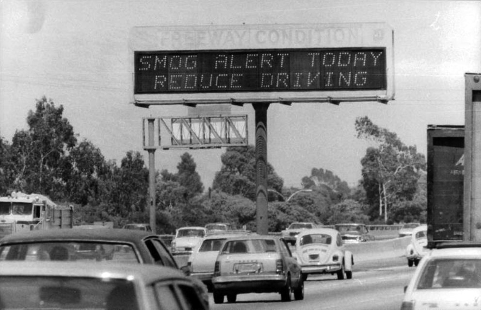
| (1980)* - Freeway sign reads: "SMOG ALERT Reduce Driving". |
Historical Notes In the 1970s and 1980s formal Smog Alerts were issued asking people to reduce driving. Schools were also affected by Smog Alerts. If the alert was bad enough, recess was cancelled and children were kept inside to play board games. Unfortunately, classrooms didn’t have air conditioning or filters so being inside wasn’t much better than being outside. Smog Alerts came in three stages: Stage 1 – Unhealthy; Stage 2 – Very Unhealthy; Stage 3 – Hazardous |
 |
|
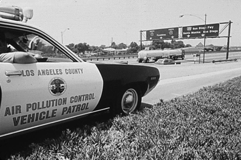
| (1980s)^ – An air pollution control vehicle sits by the side of the freeway looking for violators of the new air emission laws. |
| Historical Notes
Enforcement marked a major change from earlier decades. Instead of simply asking for cooperation, agencies now inspected vehicles and issued penalties. For drivers, clean air rules became part of owning and maintaining a car, not just a suggestion. |
 |
|
| (1973)* - View looking northeast showing downtown Los Angeles on a smoggy day with with the San Gabriel Mountains in the background. City Hall can barely be seen at center-right. |
| Historical Notes
This period shows the last years of severe smog before major improvements began. Residents had lived with dirty air for so long that many doubted it could ever change. Stronger regional agencies and stricter vehicle standards would soon begin to prove otherwise. |
 |
|
| (1970s)* - View of downtown Los Angeles office towers, barely visible through the smog as seen from the Hollywood Freeway. |
| Historical Notes
Scenes like this marked the peak years of severe smog. Downtown buildings regularly vanished behind thick haze, and emergency alerts warned residents to limit activity. For many Angelenos, this period represented the worst the air would ever get. |
 |
|
| (1986)* - View of Wilshire Blvd. looking east from San Vicente at 11:30 a.m. on December 5, 1986, following five first-stage smog alerts. |
| Historical Notes
In 1987, AQMD established a landmark rideshare program requiring companies employing at least 100 people to offer incentives to workers to carpool or use public transit. Employers complained that it shouldn’t be their job to change workers’ driving behavior, and the project went away in a few years. |
 |
|
| (1970s)* - A driver fights the smog in 1970s Los Angeles. |
| Historical Notes
By the 1970s, drivers adapted their habits to dirty air. Windows stayed shut, vents were adjusted, and long drives meant tired eyes and sore throats. Smog was no longer shocking, it was something people learned to live with. |
 |
|
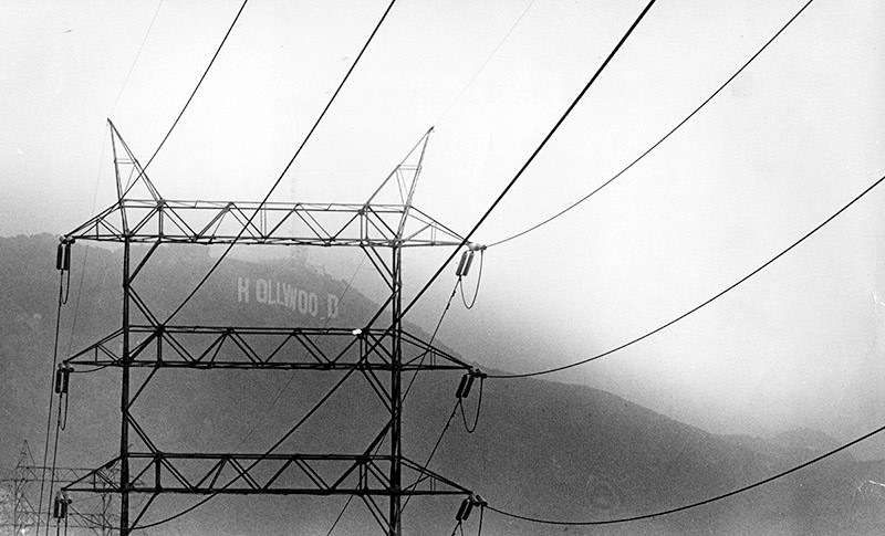
| (1979)* - Photograph caption dated September 14, 1979 reads, "The Hollywood sign is barely visible through the smog in this photo taken from above Lake Hollywood in Cahuenga Pass." |
| Historical Notes
Images like this helped convince leaders that smog harmed the city’s image as well as its health. Tourism and quality of life became part of the argument for cleaner air. Political support grew as smog was seen as an economic and cultural problem, not just an environmental one. |
 |
|
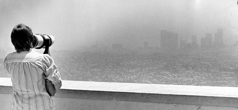
| (1984)* - A tourist at the Griffith Park Observatory focuses her telescope for a sharper view of what appears to be a city skyline, looming through the smog. Photo date: August 10, 1984 |
| Historical Notes
By the 1980s, air quality had begun to improve slowly, but smog was still common. Programs like vehicle emissions testing changed everyday behavior by requiring repairs before cars could be registered. These rules helped turn cleaner air into a long term trend rather than a short break. |
 |
|
| (1973)* - The tall buildings in downtown Los Angeles rise above a blanket of smog. |
| Historical Notes
Most of smog found in Los Angeles is a type of air pollution derived from vehicular emission from internal combustion engines and industrial fumes that react in the atmosphere with sunlight to form secondary pollutants that also combine with the primary emissions to form photochemical smog. |
 |
|
| (1982)* – Aerial view of DTLA from over the Santa Monica and Harbor Freeways interchange on a smoggy day. |
| Historical Notes
From above, freeway interchanges stand out as centers of pollution. Neighborhoods closest to these crossings often faced the worst air quality, day after day. This uneven exposure raised growing concerns about fairness and who paid the highest price for the city’s car centered growth. |
 |
|
| (ca. 1979)* - View from Elysian Park looking south along the Pasadena Freeway from Buena Vista Drive about 11:00 a.m. Downtown Los Angeles office buildings nearly disappear into the smog. |
| Historical Notes
Scenic overlooks like Elysian Park offered clear proof of how widespread smog could be. What should have been a sweeping city view instead became a gray wall. Residents began to measure air quality by what landmarks they could or could not see. |
 |
|
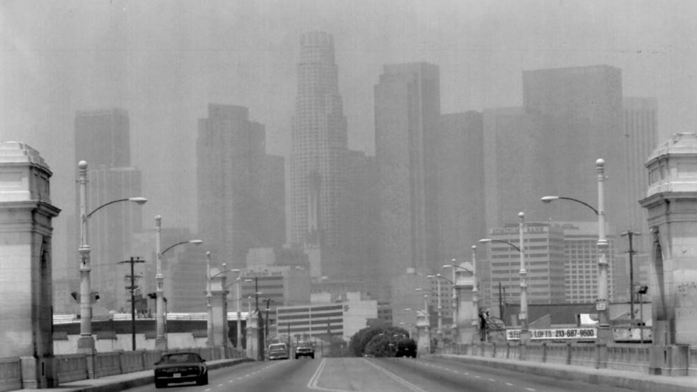
| (1993)^^ - The Los Angeles skyline shrouded in smog as seen from the 1st street bridge in July 1993. |
| Historical Notes
In 1993, bowing to pressure to do its part to revive the sluggish economy, the AQMD approved a program that allowed major polluters to trade emission credits among themselves. The program, dubbed RECLAIM, proved ineffective and fed the agency’s soft-on-the-bad-guys reputation that continues to this day. Some 58 bills were introduced in Sacramento that would exert control over the AQMD and state Air Resources Board and make them more business-friendly. * |
 |
|
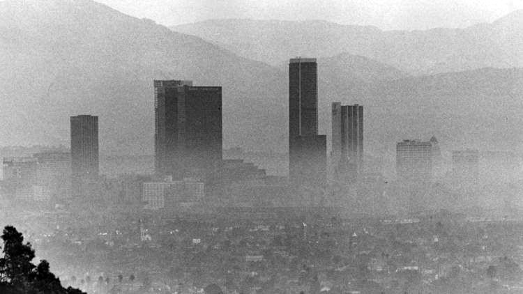
| (1990s)* – View of the downtown LA skyline through a thick layer of smog as seen from Hollywood. Photo by Ron Eisenberg / Time Magazine |
| Historical Notes
Despite earlier improvements, smog still lingered into the 1990s. This period showed both progress and limits. Air quality was better than in the 1950s, but poor visibility and health warnings reminded residents that clean air was still a work in progress. |
 |
|
| (2003)^^ – The downtown Los Angeles skyline peaks out above a layer of smog as seen from Griffith Park. |
| Historical Notes
Legal challenges from automakers slowed progress toward cleaner vehicles nationwide. Even so, earlier laws had already changed daily life by reducing the worst pollution levels. Smog no longer defined the city the way it once had, but it had not disappeared. |
 |
|
| (2015)^^ – Downtown skyscrapers reflect the light from the setting sun as seen from more than 20 miles away on the Palos Verdes Peninsula. (Los Agneles Times) |
| Historical Notes
The year 2000 saw a milestone in that no Stage One smog alerts were issued for that year, compared to 42 days in 1990, when people with respiratory problems were urged to stay indoors. |
 |
|
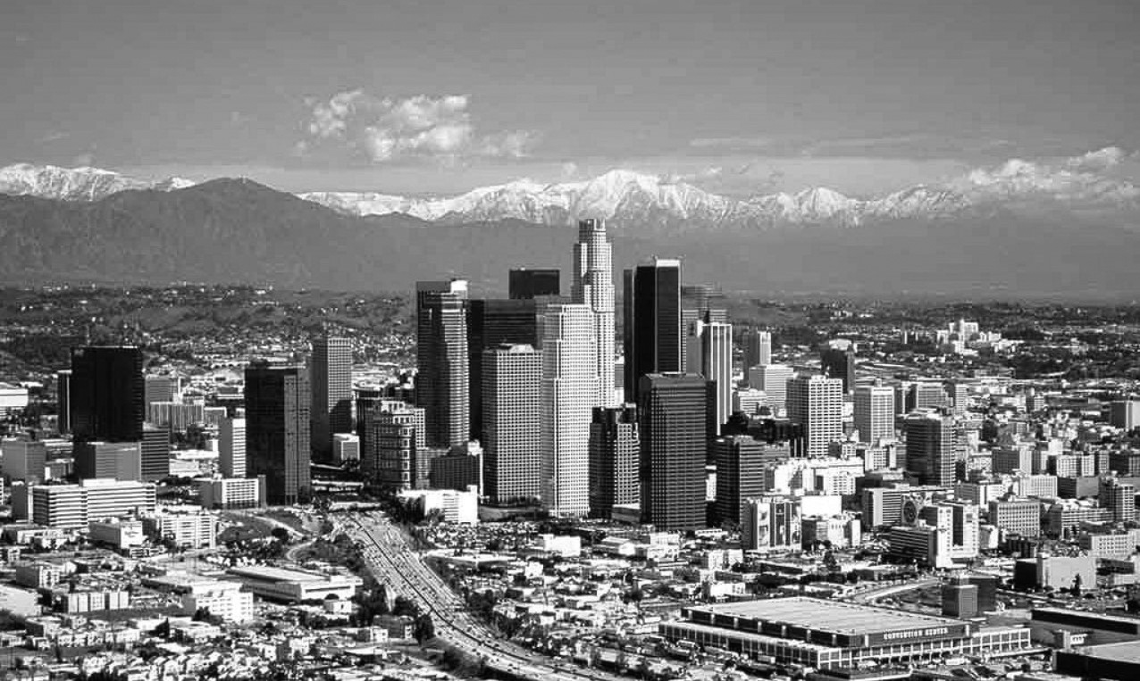
| (2005)++ – Panoramic view looking northeast showing downtown Los Angeles, with snow-capped San Gabriel Mountains in the background. The Harbor Freeway and LA Convention Center are in the foreground. Photo by Daniel Castro |
| Historical Notes
Although a pristine view of the downtown skyline may still elude Angelenos on most days, air pollution rarely cripples the city in present times as it did in the mid-twentieth century. Severe smog has largely abated. This was all due to citizen activism, scientific advances, and landmark environmental legislation that allowed the EPA to regulate air pollutants. |
 |
|
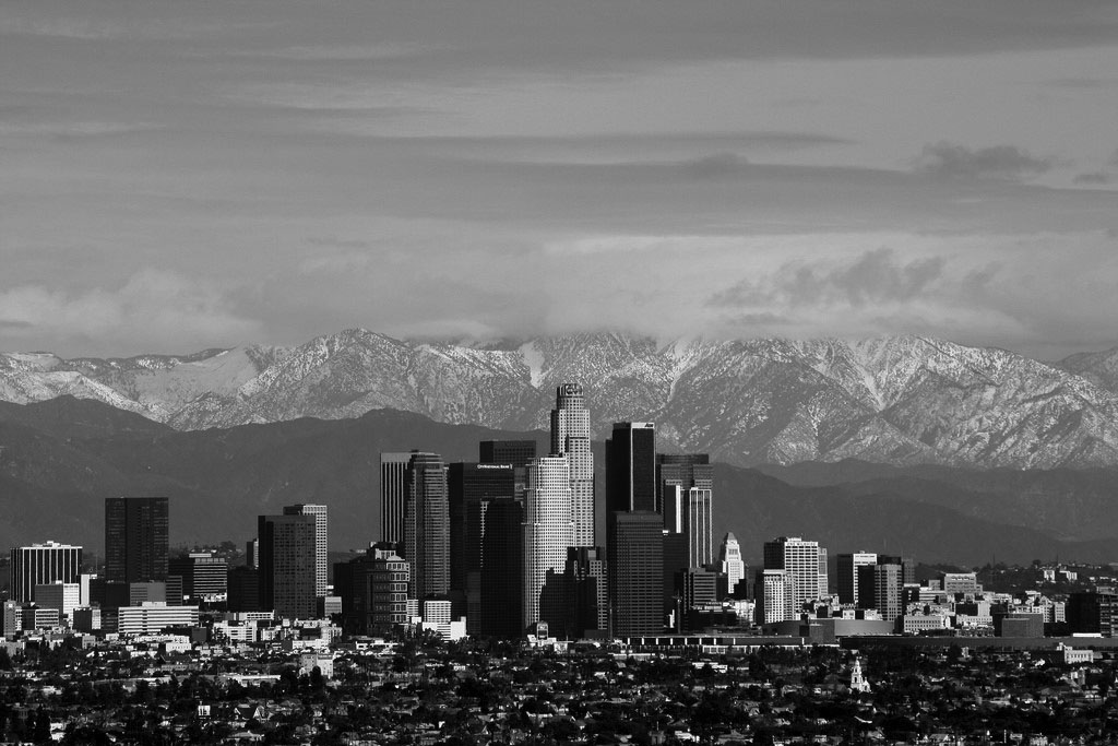
| (2013)* – A slightly different angle view also showing downtown Los Angeles with the beautiful snow-capped San Gabriel Mountains in the background. City Hall is seen at lower center-right. Once the tallest building in Los Angeles (1928 thru 1964), City Hall is now dwarfed by scores of other high-rise buildings. Photo by Todd Jones |
| Historical Notes
In the 1970s and '80s, the Los Angeles region often saw more than 200 bad-air days a year, with ozone levels exceeding 300 parts per billion on the smoggiest summer days. Peak ozone concentrations have dropped to about a third of that, even as the region’s population has grown and the number of vehicle miles traveled has doubled. The success of emissions standards that began more than four decades ago, especially The Clean Air Acts of 1970 and 1977, has slashed air pollution in Southern California by 70% since 1970. |
 |
|
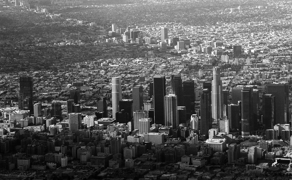
| (2008)* - Aerial view of Downtown Los Angeles with Wilshire Blvd in the background heading off to the west. Photo by Ron Reiring |
| Historical Notes
By the early 2000s, improvements were easier to see from the air as well as the ground. While smog had not vanished, severe episodes were less frequent and less intense. Longtime residents recognized the change as something once thought impossible. Over the past several decades, California officials set groundbreaking standards that phased out many inefficient car and truck engines and some of the dirtiest fuels for everything from jet skis and lawnmowers to school buses and heavy-duty trucks. Local smog-fighters in the Los Angeles basin forced cleanup of oil refineries, manufacturing plants, and consumer products such as paints and solvents. Other local and state programs offered incentives for replacing old trucks and buses. The result: Some of the most problematic pollutants—smog-forming nitrogen dioxide and fine particles created by diesel-engine exhaust and other fossil fuels—declined in the worst neighborhoods by up to 50 percent in 20 years. Much more can still be done. |
* * * * * |
Clarity and Change: Smog, Streets, and the Transformation of Downtown L.A.
.jpg) |
|
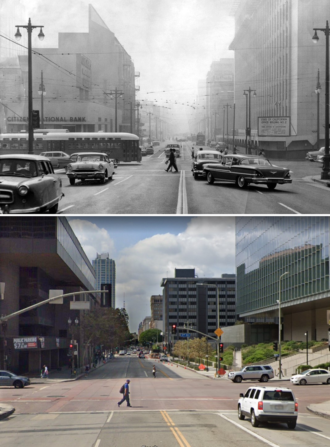
| (1955 vs. 2016)* - Looking east on 1st Street at Olive Street in DTLA. Two things to note here: (1) Air Quality change since 1955 (top photo) and (2) How much 1st Street (Bunker Hill) was shaved down. Photo comparison by Jack Feldman. |
| Historical Notes
In the 1955 view looking east on 1st Street at Olive, dense smog hangs over the Civic Center, partially obscuring City Hall and other public buildings. The murky skies were typical of mid-century Los Angeles, when air quality reached crisis levels due to unchecked vehicle emissions and industrial pollutants. This image also captures a moment just before downtown’s topography was dramatically reshaped. Bunker Hill, once a steep and elevated residential area, was literally shaved down—flattened by more than 30 feet in some areas—as part of the city’s massive redevelopment effort beginning in the 1950s. By 2016, the same view reveals a radically altered streetscape and a striking improvement in air quality, a result of decades of regulatory progress, including the introduction of catalytic converters, emissions testing, and the founding of the South Coast Air Quality Management District (AQMD). The difference between the two photos is not just visual—it's environmental, political, and architectural. |
Then and Now
 |
|
| (1959 vs. 2022)* - Looking south on Broadway at 1st Street in DTLA. Photo comparison by Jack Feldman. |
| Historical Notes
This 1959 view looking south on Broadway from 1st Street captures a city amid transformation. In the foreground, traffic fills the street under a layer of smog typical of the era, while overhead wires for streetcars—already in decline—still hang above. Though City Hall isn’t visible in this frame, it’s nearby, just east of the intersection. The surrounding buildings reflect a low-rise, pre-redevelopment downtown, with a mix of early 20th-century commercial structures that would soon be overshadowed—both physically and culturally—by larger civic and cultural projects. By 2022, this corridor had been fully reimagined. Streetcars had vanished, sidewalks had been widened, and nearby landmarks like Grand Park, the Broad Museum, and updated government buildings helped define a more pedestrian-friendly civic core. The most noticeable difference may be the air itself—clear and bright, in contrast to the haze that once regularly blanketed the heart of Los Angeles. |
Then and Now
 |
|
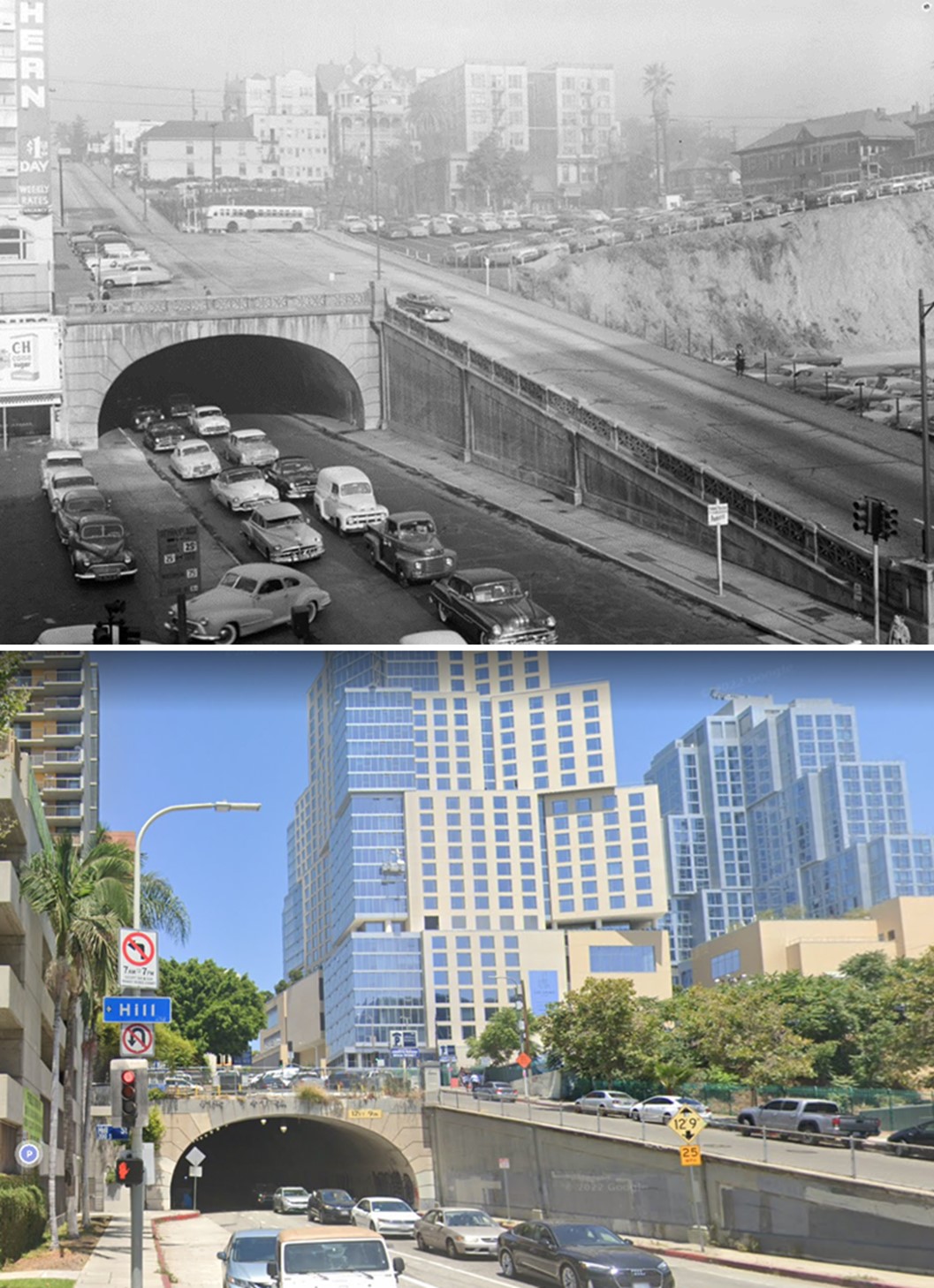
| (1950s vs 2022)* - Looking west on 2nd Street from Hill Street towards Bunker Hill, DTLA. Photo comparison by Jack Feldman. |
| Historical Notes
In this 1950s photograph looking west through the 2nd Street Tunnel from Hill Street, a line of automobiles inches out of the portal, caught in the slow churn of downtown traffic beneath a blanket of smog. Perched above the tunnel are the rooftops of Bunker Hill’s once-grand Victorian homes and mid-rise apartment buildings—remnants of a neighborhood already in decline and on the brink of erasure. A small parking lot atop the slope reflects the postwar shift toward car-centric planning, even in the city’s core. By the 2020s, nearly every building in the old scene had been demolished and replaced as part of the Bunker Hill Redevelopment Project. The modern view reveals a dramatically altered skyline featuring The Grand LA by Frank Gehry and the Conrad Los Angeles Hotel, completed in 2022. Although the tunnel itself remains, it now frames a thoroughly transformed Los Angeles—clearer, taller, and reshaped by 70 years of planning, ambition, and environmental reform. |
* * * * * |
Please Support Our CauseWater and Power Associates, Inc. is a non-profit, public service organization dedicated to preserving historical records and photos. Your generosity allows us to continue to disseminate knowledge of the rich and diverse multicultural history of the greater Los Angeles area; to serve as a resource of historical information; and to assist in the preservation of the city's historic records.
|
* * * * * |
|
Other Sections of Interest |
|
Water and Power in Early LA |
|
Newest Additions |
New Search Index |

A new SEARCH INDEX has been added to help navigate through the thousands of topics and images found in our collection. Try it out for a test run.
Click HERE for Search Index |
* * * * * |
References and Credits
* LA Public Library Image Archive
^ KCET: LA's Smoggy Past in Photos;
** UCLA Library Digital Archive
#+ AQMD - The Southlands War on Smog
#^ LA Smog: The Battle Against Air Pollution
^^ LA Times: Los Angeles Under Cover - Smog Through the Years; New Attack on California's Dirty Air
+^ Facebook.com: SoCal Historical Architecture
#* Facebook.com: Photos of Los Angeles
## Flickr-Los Angeles in Good Light - Ron Reiring
*^ Wikipedia
^* National Geographic: As Smog Thins in L.A., Dramatic Evidence of Kids' Healthier Lungs
^# WIRED: July 26, 1943: L.A. Gets First Big Smog
< Back