Early Views of the Los Angeles Plaza
| Historical Photos of Early Los Angeles |
 |
|
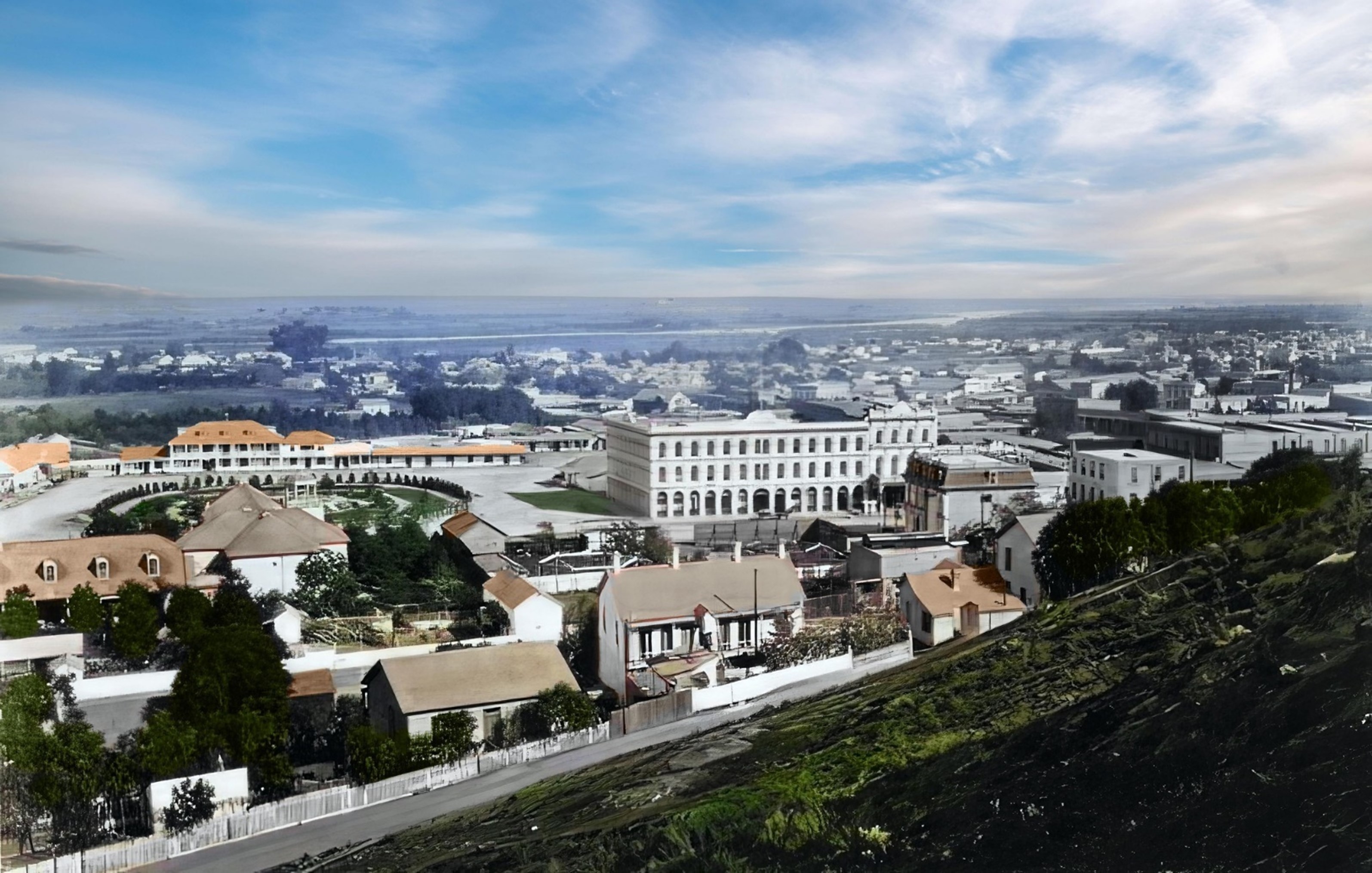
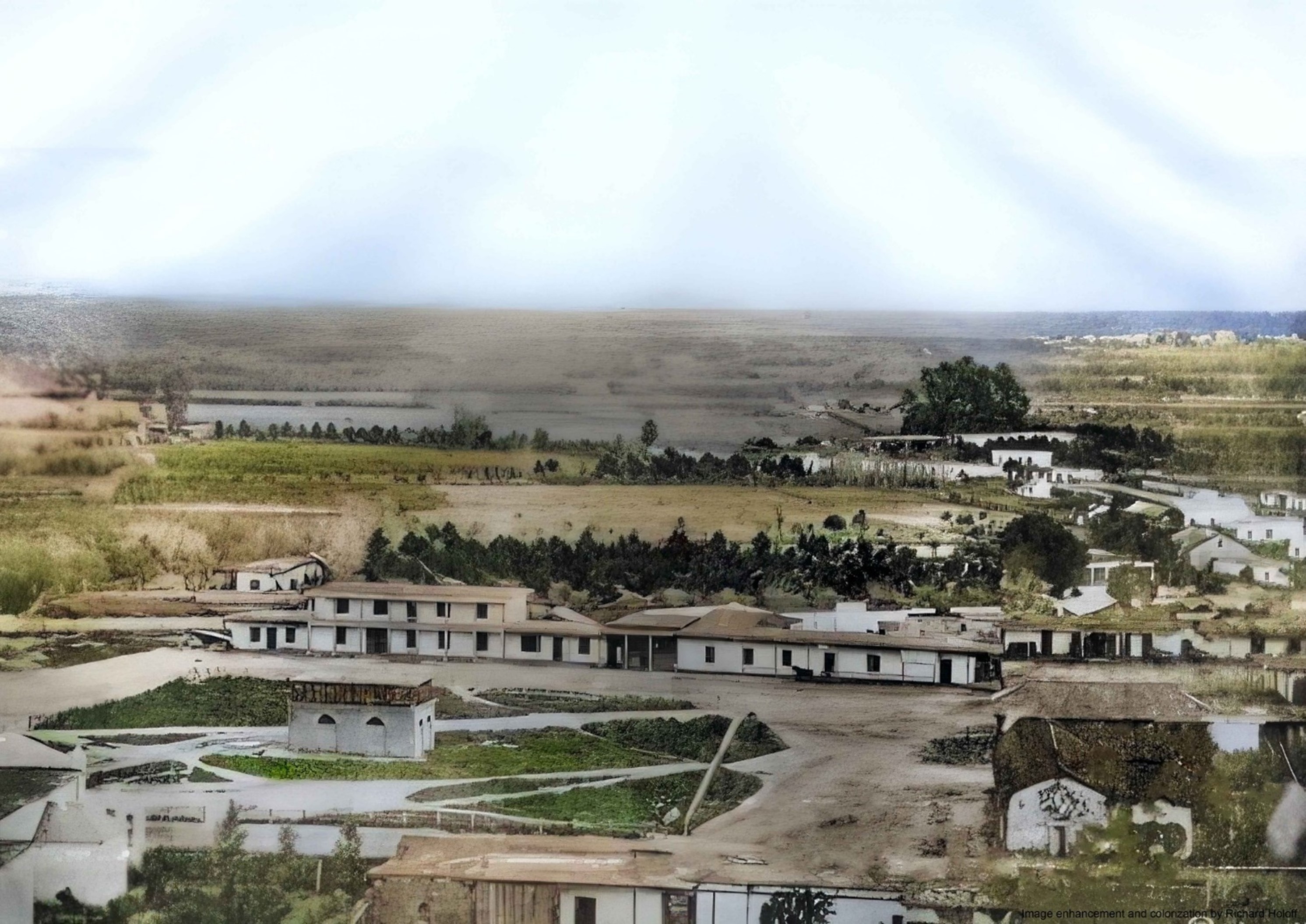
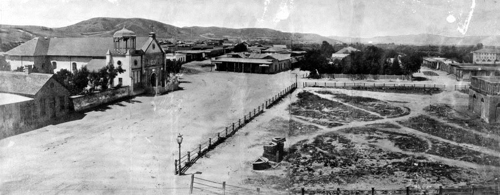
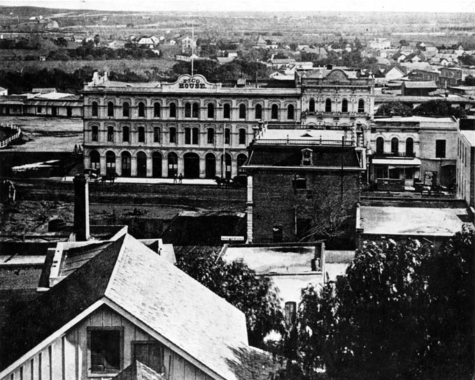
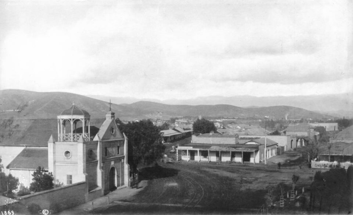
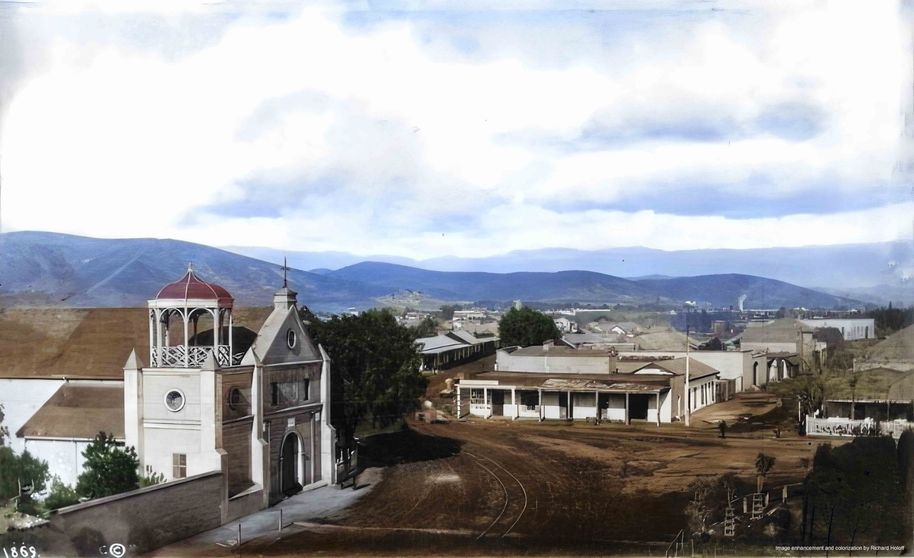
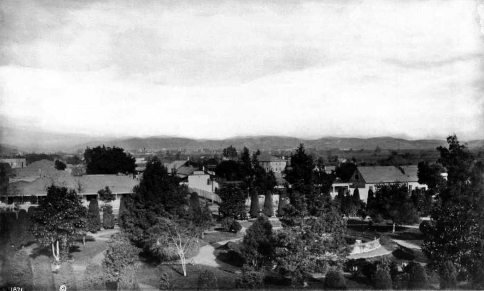
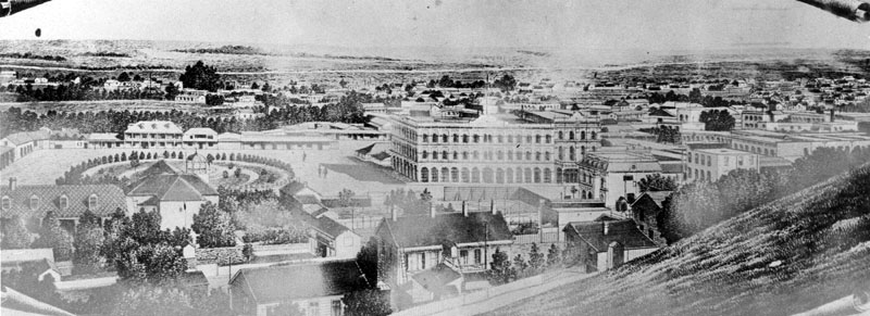
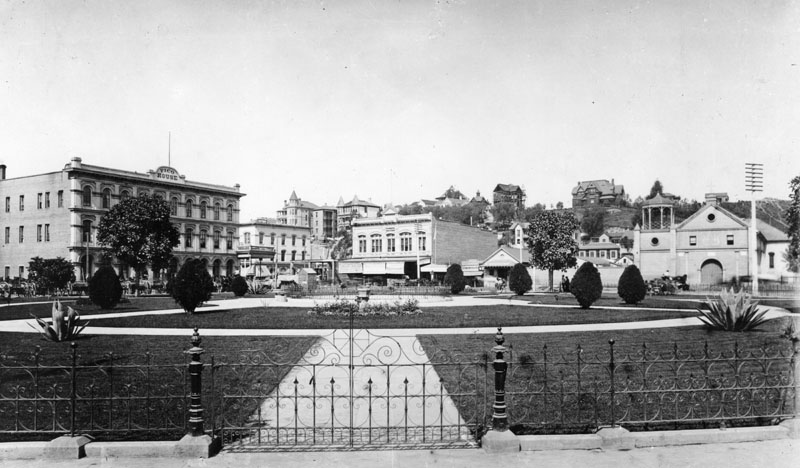
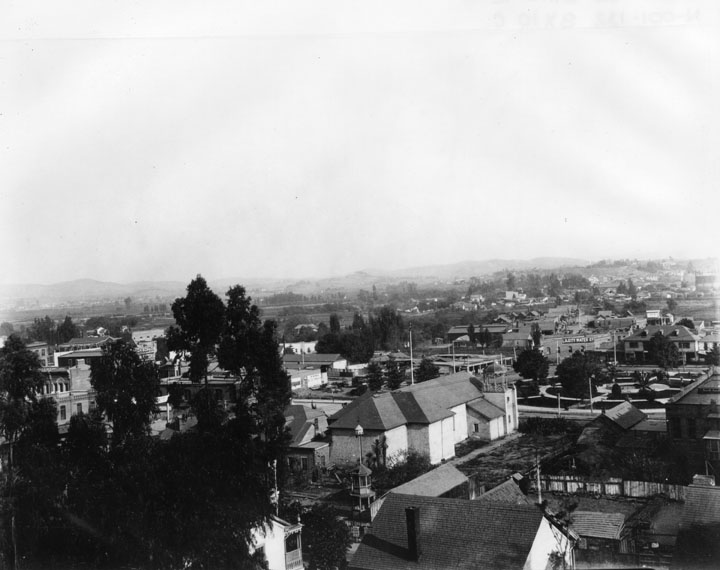
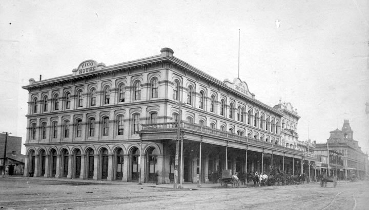
| Panoramic view of the Los Angeles Plaza as it appeared 1876. The Pico House is the prominent 3-story white building at the center of the photo. The back of the Old Plaza Church is in the lower-center left with Los Angeles River seen in the distance.* |
Historical Notes The Los Angeles Plaza Historic District, also known as El Pueblo de Los Angeles State Historic Park, is located at the oldest section of Los Angeles, known for many years as "El Pueblo de la Reina de Los Angeles". The district, centered on the old plaza, was the city's center under Spanish (1781–1821), Mexican (1821–1847) and United States (after 1847) rule through most of the 19th Century. The one person most responsible for the founding of Los Angeles was the new Governor of California, Felipe de Neve. In 1777 Neve toured Alta California and decided to establish civic pueblos for the support of the military presidios. The new pueblos would reduce the secular power of the missions by reducing the dependency of the military on them. At the same time, they would promote the development of industry and agriculture. Neve identified Santa Barbara, San Jose, and Los Angeles as sites for his new pueblos.* |
 |
|
| (1876)* – Los Angeles Plaza and beyond. Note: The LA River can be seen in the distance. (Image enhancement and colorization by Richard Holoff) |
Earlier Plaza Views
 |
|
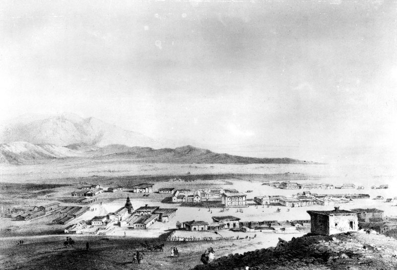
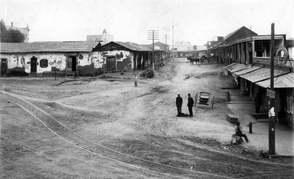
| (1853)* - This picture was scanned from a rare stone lithograph of downtown Los Angeles, cut in 1853, known as the "Survey View." The view is from Fort Moore Hill looking east, toward the LA River. |
Historical Notes The City of Los Angeles originated right here. Nuestra Señora la Reina de los Angeles was founded on September 4, 1781 by a group of Spanish pobladores (settlers), consisting of 11 families – 44 men, women and children. They were originally led by Fernando Javier Rivera y Moncada (1725-1781), and accompanied by a contingent of soldiers – who had set out from the nearby Mission San Gabriel Arcángel to establish a pueblo along the banks of the Porciúncula River at the Indian village of Yangna. The church was considered an asistencia (“sub-mission”). Priests from Mission San Gabriel divided their time between the mission and the Asistencia site. |
 |
|
| View showing a model of Los Angeles as it appeared in 1850. Looking northeast, the layout of the new city can clearly be seen with the Los Angeles Plaza located in the lower left-center. The large white structure to the left of the Plaza is the Old Plaza Church. The two streets running from bottom of photo to the Plaza are Main Street on the left and Los Angeles Street on the right. Alameda Street runs from the lower right corner diagonally toward the lower center of photo. The L.A. River can be seen running from the lower-right diagonally to the center of the photo, turns left and disappears behind the mountain. At that point the Arroyo Seco can be seen at its confluence with the LA River. The tall majestic San Gabriel Mountains stand in the far background. Vineyards blanket the area between the City and the L.A. River (lower right). The large dark spot in the lower-right of the photo is El Aliso, the historic landmark of the indigenous Tongva people who once lived in the Indian Village of Yangna at that location, adjacent to the Los Angeles River. Note: Picture file card identifies the above image as a diorama of the Pueblo Los Angeles as it appeared in 1850 as designed by J. Marshall Miller. Picture file card also reads "Prepared for the Los Angeles Times Anniversary 1931?".** |
Historical Notes It wasn't until April 4, 1850 that Los Angeles was incorporated as a municipality, five months before California achieved statehood. In 1850, the population of Los Angeles was only 1610.* |
.jpg) |
|
| (ca. 1850)^** - Photo of a sketch showing the LA Plaza and surounding area as it appeared in 1850. The Old Plaza Church appears at upper left. The map is based on the 1849 Ord Survey. |
Historical Notes Click HERE to see more in an Interactive Map of Early Los Angeles as it appeared in 1850. |
 |
|
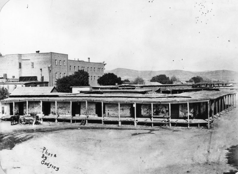
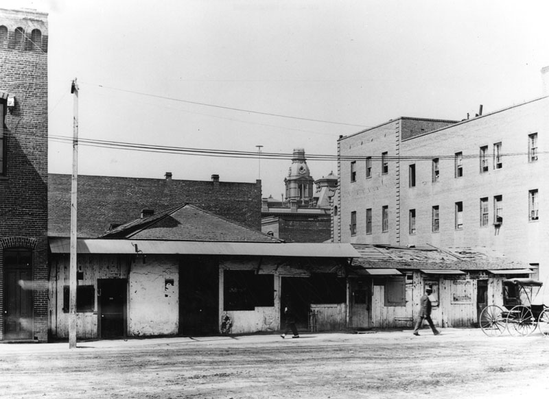
| (ca. 1858)* - This is the earliest known close-up photograph of the Los Angeles Plaza. There is a square main brick reservoir in the middle of the Plaza, which was the terminus of the town's historic lifeline: the Zanja Madre ('Mother Ditch'). The reservoir was built in 1858 by the LA Water Works Company. Click HERE to read more about the Zanja Madre and Los Angeles' first water supply. |
Historical Notes The site of the Plaza today is not the original location. It is the second, third, or maybe even the fourth. One of the earlier plots is believed to be around where the current Pershing Square sits. It’s also thought that at least one of the first three was washed away in a flood. The current Plaza dates from as early as 1815. When early settlers arrived at the Los Angeles River by way of Mission Road, they picked as a nearby gathering point a huge sycamore (upper right-center of photo) that gave them shelter and became a landmark, "El Aliso." That Spanish word for sycamore was later used to name the road carved out near the river (Aliso Street in 1854). El Aliso (upper center-right of photo) sprang from the ground near the western bank of the Los Angeles River in the late fifteenth century, about the same time Columbus arrived in the Americas. As it matured, the sycamore -- located at the juncture of the Los Angeles coastal plain and the San Fernando and San Gabriel valleys -- became a gathering place for Los Angeles' indigenous Tongva people. Local leaders traveled from their villages across Southern California to confer under the shade of the tree's canopy. By the mid-eighteenth century, the mighty sycamore stood at the center of one of the largest Tongva villages, Yangna. By the 1830s, due to the encroachment of the pueblo, El Aliso had ceased to function as the symbolic center of daily Tongva life as Yangna changed locations twice before dissolving into historical oblivion.* |
 |
|
| (ca. 1858)* - This is the earliest known close-up photograph of the Los Angeles Plaza. There is a square main brick reservoir in the middle of the Plaza, which was the terminus of the town's historic lifeline: the Zanja Madre ('Mother Ditch'). The reservoir was built in 1858 by the LA Water Works Company. Image enhancement and colorization by Richard Holoff. |
Historical Notes Click HERE to read more about the Zanja Madre and Los Angeles' first water supply. |
.jpg) |
|
| (ca. 1860)* - One of Los Angeles' first water reservoirs was the brick structure shown in the center of the Plaza. The adobe directly behind was owned by Augustin Olvera. The 3-story building in the background was at the site of the City's first hospital (Sisters of Charity Hospital), orphanage and school. |
Historical Notes In 1857, the city council granted William Dryden a franchise to deliver water to homes through a system of wooden pipes beneath the streets. Dryden and his newly incorporated water company, Los Angeles Water Works Co., erected a forty foot water wheel to lift water from the LA River to the city's main water ditch. In 1858, the LA Water Works Co. constructed a large brick and wood storage tank in the center of the city plaza as seen above. It would remain there for about 10 years and then replaced by a fountain. Water would be continued to be stored in other tanks on the periphery of the plaza as well as in other nearby reservoirs. In 1860, the population of Los Angeles was 4385, almost three times what it was 10 years earlier.* Click HERE to read more about Water in Early L.A. Also, click HERE to see more Early LA Water Reservoirs. |
 |
|
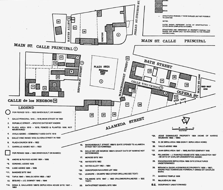
| Map showing the LA Plaza area as it appeared in 1860. Adobe structures are predominately on all sides.* |
 |
|
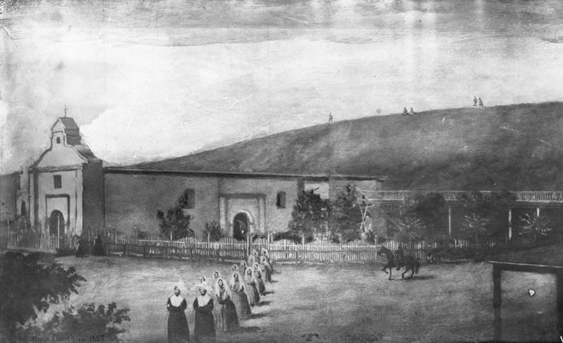
| (1857)* - Photograph of a drawing (by a young lady pupil of Sister's School) of the Los Angeles Plaza Church with a group of 14 nuns processing in the foreground. A wooden picket fence extends from the church at left to the right. A horseman prances nearby (at right). Two people stand near the church entrance (at left). A few other people are visible on the bare hilltop behind. |
Historical Notes The 'Church of Los Angeles' was founded on August 18, 1814 by Franciscan Fray Luis Gil y Taboada. He placed the cornerstone for the new church in the adobe ruins of the original "sub-station mission" here, the Nuestra Señora Reina de los Ángeles Asistencia (founded 1784), thirty years after it was established to serve the settlement founding Los Angeles Pobladores (original settlers).* |
 |
|
| (1860)* - Photograph of a lithograph from Benjamin Nayer's diary depicting the exterior of the Plaza Church in Los Angeles, 1860. |
Historical Notes The completed new structure was dedicated on December 8, 1822. A replacement chapel, named La Iglesia de Nuestra Señora de los Ángeles - for Mary, mother of Jesus or "The Church of Our Lady of the Angels" - was rebuilt using materials of the original church in 1861. The title Reina, meaning "Queen," was added later to the name. For years, the little chapel, which collected the nicknames "La Placita" and "Plaza Church," served as the sole Roman Catholic church in emerging immigrant Los Angeles.* |
 |
|
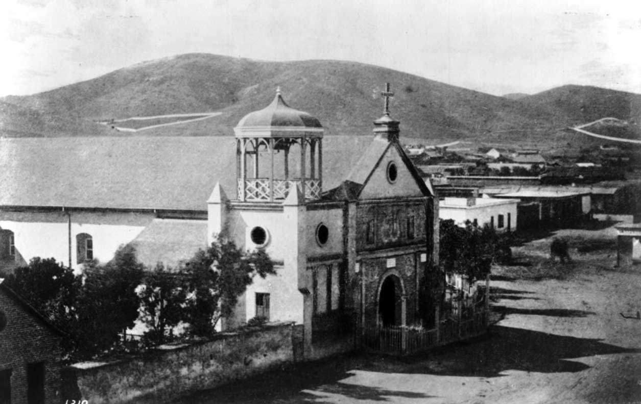
| (1869)* - View of the 'Old Plaza Church' (Mission Nuestra Senora Reina de Los Angeles) with bare hills in the background. Chavez Ravine, over the church at left, is where Dodger Stadium is now. |
Historical Notes The 'Old Plaza Church' was one of the first three sites designated as Historic Cultural Monuments by the City of Los Angeles, and has been designated as a California Historical Landmark No. 144. Click HERE to see the complete listing of California Historical Landmarks in L. A. |
 |
|
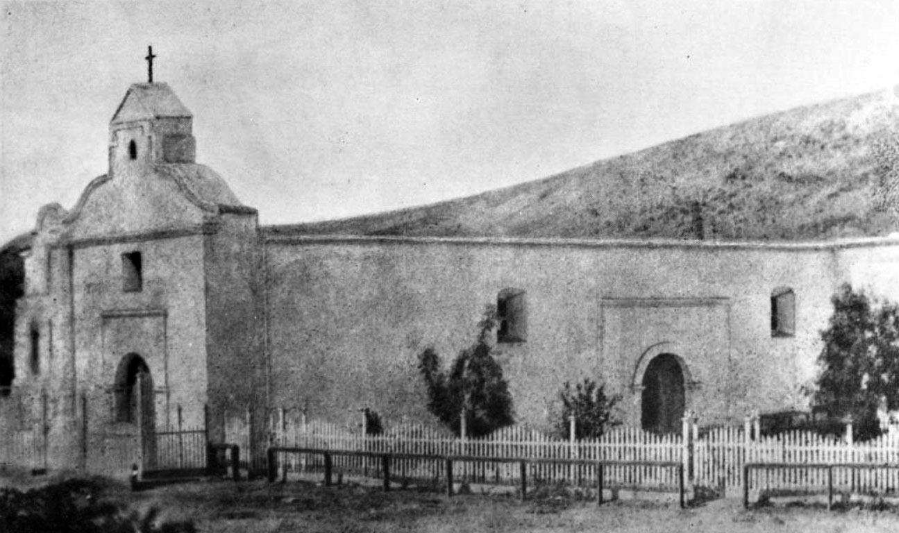
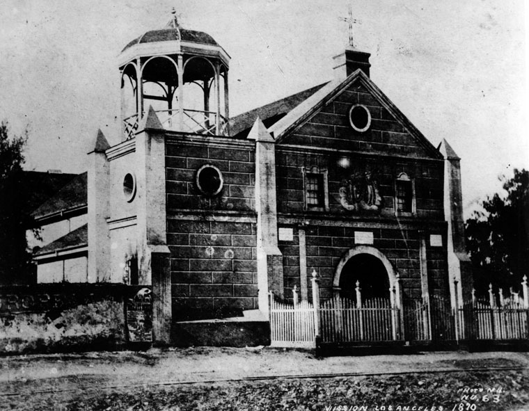
| (1870)* - Close-up detailed showing the front entrance to the 'Old Plaza Church'. |
Historical Notes The original 1822-built "Church of Our Lady of the Angels" incoporated a three-bell campanario, or "bell wall" which was replaced by a gazebo-like structure (seen above) when the Church was rebuilt in 1861. The "bell wall" or "bell gable" would once again return when the Plaza Church was repaired/remodeled circa 1901.* |
 |
|
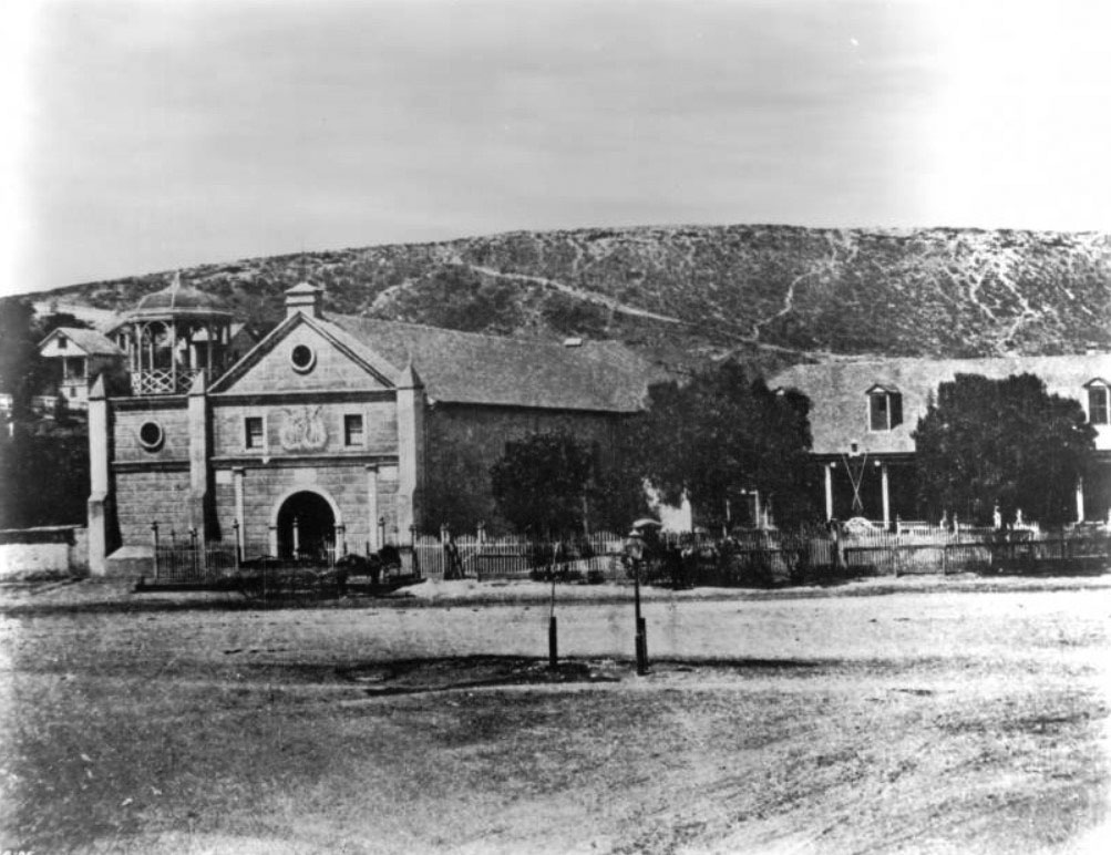
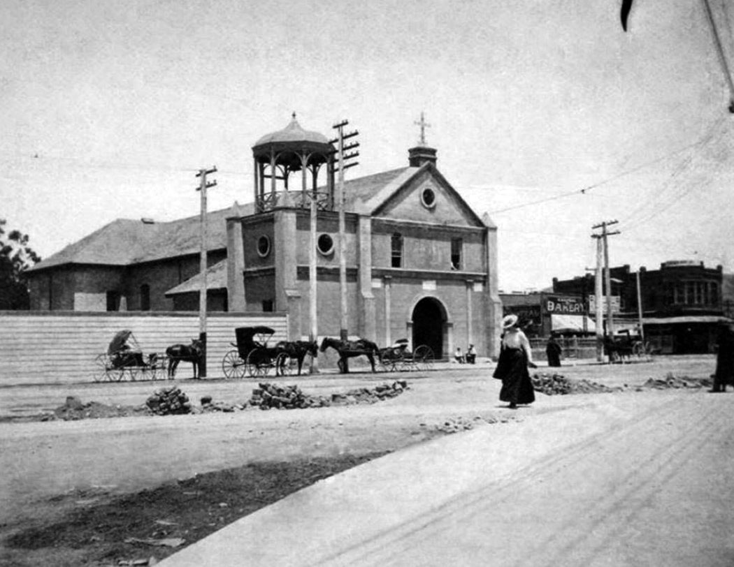
| (1870s)* - Exterior view of the Plaza Church or Mission Nuestra Senora de La Reina de Los Angeles. In front of the church is a fence that encloses the yard (at right). Three trees in the yard hinder the view of the building in the background. Two horse-drawn carriages are parked in front of the church and near the fence. |
Historical Notes IThis is about the time LA Plaza's configuration changed from square to circular. One of the two posts seen in the center of the street appears to be the old gas lamp which was located on the northwest corner of the old square plaza. |
 |
|
| (ca. 1868)** - A view of the northwest corner of the Los Angeles Plaza. This is the intersection of Calle Principal (Main Street) and Marchessault Street. Note the gas lamp at the corner of the Plaza. |
Historical Notes In 1867, Los Angeles Gas Company, the forerunner of today's Southern California Gas Company, installed 43 new gas lamps along Main Street, making the city safer at night. The gas lighting business was run by five entrepreneurs who manufactured the gas from asphalt, a tar-like substance, and later from oil. The gas company's plant, including two large tanks, was located across the street from the Plaza, just south of the Old Plaza Church (see next photo). |
 |
|
| (ca. 1871)*** - Photograph of a lithograph of Los Angeles with the LA Plaza and Pico House at center-right. The lithograph shows Los Angeles at an early age where most of the city consists of agricultural land showing orchards and farmland (foreground). Majority of the homes and buildings are clustered closer to the mountains in the background. |
.gif) |
|
| (1873)* - Ruxton Survey of the Central Pueblo. This oversize plat shows the plaza area in 1873, including the center of town with the early buildings and the zanza madra (zanja madre) which was LA's original water aqueduct and lifeline. The map also shows the streets in use and the early owners of many of the properties. The layout of the plaza itself, however, is shown as it appeared before the change in landscaping in the prior two years before it became rounded. |
Historical Notes Calle Principal is now Main Street and follows the old Bath Street, while the upper portion of Calle Principal became Upper Main and later Spring Street, and no longer exists below Sunset Boulevard. (Its remnants can be seen in El Pueblo de Los Angeles Parking Lot Number 2.) Calle de los Negros (then disparagingly called "Nigger Alley") is now the east side of Los Angeles Street. Wine Street is now Olvera Street. Sunset Boulevard (at one time called Short Street) originally ran down Church (Bread) and Marchessault Streets; now it follows a more direct path to connect with Macy Street, and this portion was recently renamed Cesar E. Chavez Street. Calle Alta (old High Street) is now Ord Street. Church (Bread) Street is now an alley. Calle Corto (Short Street) no longer exists. |
 |
|
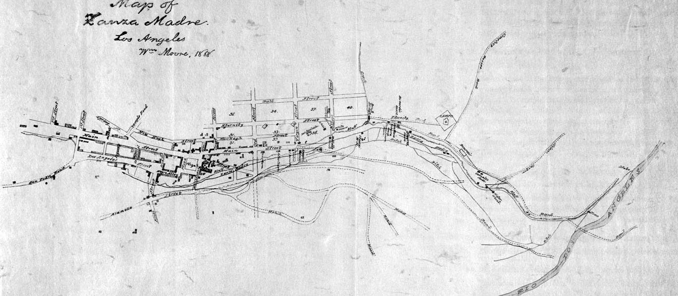
| (1868)^ - This manuscript map traces the path of the essential lifeline of early Los Angeles: the Zanja Madre, or Mother Ditch, prepared by cartographer William Moore. |
Historical Notes The Zanja Madre is shown here from the river at the right edge of the map, running along the bluffs in the proximity of current day North Broadway, completely open to the elements. A few years after this rendering, a brick tunnel enclosed the Zanja Madre in an attempt by the Common Council and the Los Angeles City Water Company to preserve the precious water flowing down from the river. The map includes the Campo Santo cemetery (the second one) at the end of Eternity Street, the water wheel that propelled the flow toward the pueblo, and the homes of pioneers like Jose Sepulveda, Abel Stearns, and Bernardo Wilson. Click HERE to see more in Zanja Madre - LA's Original Aqueduct William Moore, the rendering’s rather robust and tireless cartographer, was county surveyor for two separate terms and a man with such drive that he once tired of waiting for a ship from San Francisco and walked to Los Angeles. Because he was bi-lingual and reportedly quite charming he was involved in many important projects in the days after California gained statehood, including the planning of reservoirs, a sewer system, creation of sidewalks, the Farmers and Merchants Bank, and even orange growing for a time.*^^ |
 |
|
| (1869)* - Panoramic view of the Plaza and 'Old Plaza Church' (Mission Nuestra Senora Reina de Los Angeles). The square main brick reservoir in the middle (partial view) was the water reservoir builit by William Dryden and his LA Water Works Co. Click HERE to read more on Wiliam Dryden. |
Historical Notes The building in the top right background was the Sisters of Charity Hospital. The three adobes seen on the north side of the Plaza were owned in 1869 by M. Norton (built 1854), John Downey (shrouded by trees, built 1844) and Augustin Olvera (built 1854). They are all gone now. The first lost to the widening of Main St, the second torn down in 1894 to build the Simpson-Jones Building and the last demolished in 1916 to build the Methodist Church and Conference Center. |
 |
|
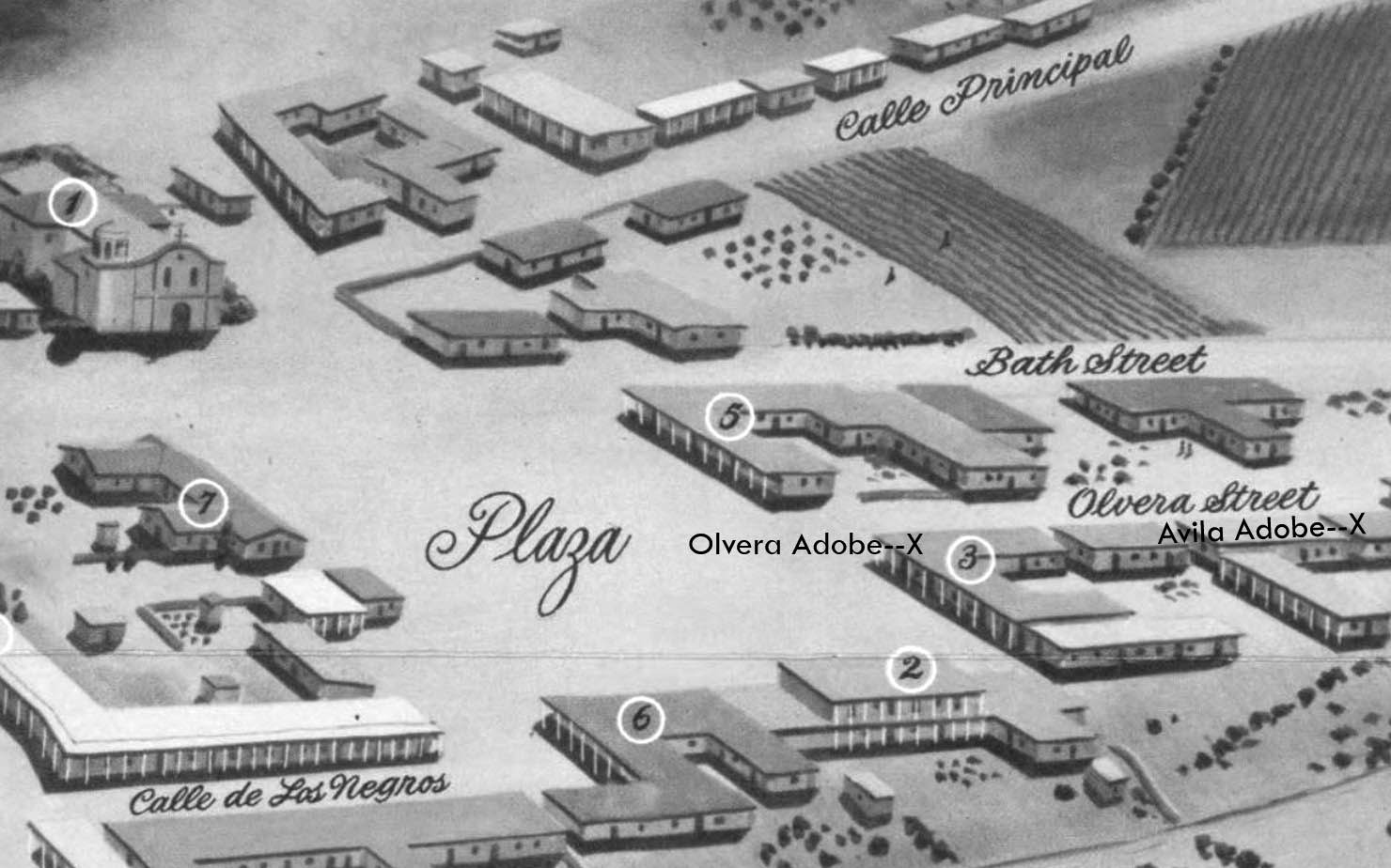
| (ca. 1869)* - View of the edge of the Los Angeles Plaza and the entrance to Wine Street (renamed Olvera Street in 1877) looking north from the Pico House. The Avila Adobe is visible on Wine Street. The Olvera Adobe can also be seen on the right. In the foreground running horizontally two fences, a wrought-iron fence and a post-and-rail fence, can be seen on either side of the street. |
Historical Notes Don Francisco Avila, a wealthy cattle rancher and one-time Mayor of the pueblo of Los Angeles, built the Avila Adobe in 1818. The Avila Adobe, presently the oldest existing residence within the city limits, was one of the first town houses to share street frontage in the new Pueblo de Los Angeles. |
 |
|
| (1850)^** - Map view looking northwest showing the LA Plaza and surrounding area as it appeared in 1850. To the right can seen Olvera Street (Wine Street until 1877) at its intersection with the Plaza, with both the Olvera Adobe and Avila Adobe locations marked with an X. The Plaza Church is in the upper left corner. The Lugo Adobe, the Plaza's only two-story building, is seen at lower right and is identified by the No. 2. |
 |
|
| (ca. 1868)** - The Plaza, looking east, with LA's first above ground reservoir to the right of the picture. The two-story building directly behind the reservoir is the Vicente Lugo adobe house. The building in front of the reservoir with the gazebo-like tower is the 'Old Plaza Church'. |
Historical Notes The Lugo Adobe, said to have been built in the 1840s by Don Vicente Lugo, was one of the very few two-story houses in the pueblo of Los Angeles. In 1867, Lugo donated this house on the Plaza to St. Vincent's School (forerunner of Loyola University).^^ Click HERE to see more of St. Vincent's College (later LMU). |
 |
|
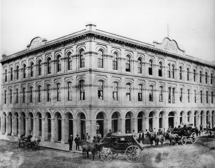
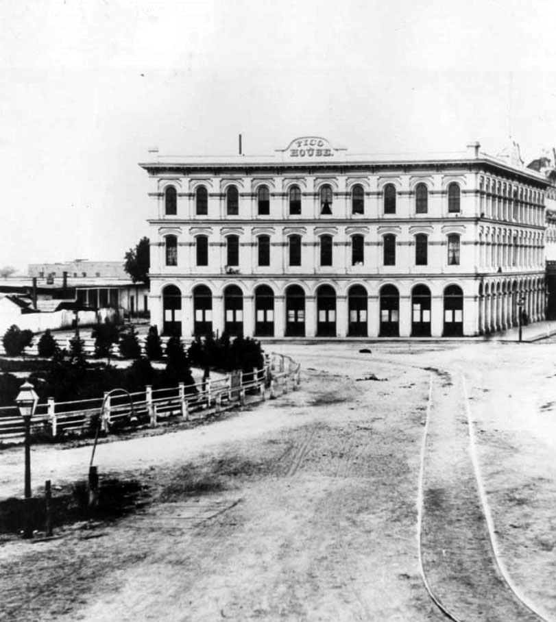
| (1869)* - View showing the Pico House, Masonic Temple and the Plaza area from a hill overlooking Spring Street and Main Street, Los Angeles, December 1, 1869. In the foreground is a community of small houses. Just beyond the community is the Pico House, which faces Main Street. The Plaza is to the left of the Pico House. The Masonic Temple (or Hall) stands several buildings to the right of the Pico House. A majority of the buildings in view are residential houses. |
Historical Notes Between 1868 and 1870, Pio Pico constructed the three story, 33-room hotel, Pico House (Casa de Pico) on the old plaza of Los Angeles, opposite today's Olvera Street. Pío de Jesús Pico was the last Governor of Alta California under Mexican rule. In 1821 Pico set up a tanning hut and dram shop in Los Angeles, selling drinks for two Spanish bits (US 25 cents). His businesses soon became a significant source of his income. By the 1850s Pico was one of the richest men in Alta California. In 1850 he purchased the 8,894-acre Rancho Paso de Bartolo, which included half of present day Whittier. Two years later, he built a home on the ranch and lived there until 1892. It is preserved today as Pio Pico State Historic Park. Pico also owned the former Mission San Fernando Rey de España, Rancho Santa Margarita y Las Flores (now part of Camp Pendleton), and several other ranchos for a total of over one half-million acres, or 800 mi². * |
 |
|
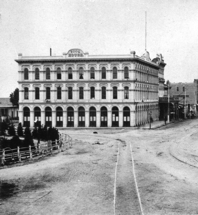
| (1870)** - On the right is the Pico House, erected by the last Mexican governor, Pio Pico. Described as "the latest thing in luxury, gas lights and several bath tubs." On the upper left appears Olvera Street. Note the big water tank reservoir in the middle of the Plaza is gone and replaced with a fountain. |
Historical Notes The Pico House was known as the "finest hotel in Southern California," boasted "bathrooms and water closets for both sexes" on each floor. Pio Pico, the last governor of Mexican California, sold his land in the San Fernando Valley to raise money for its construction. It was Los Angeles' first three story building.^#^ |
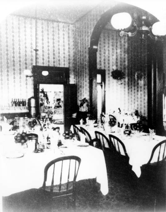 |
(ca. 1880s)*#^ - View shwoing the Pico House's French restaurant dining room.
|
Historical Notes The Pico House had 82 bedrooms, 21 parlors and two interior courtyards. It also had a French restaurant that was located on the ground floor. |
 |
|
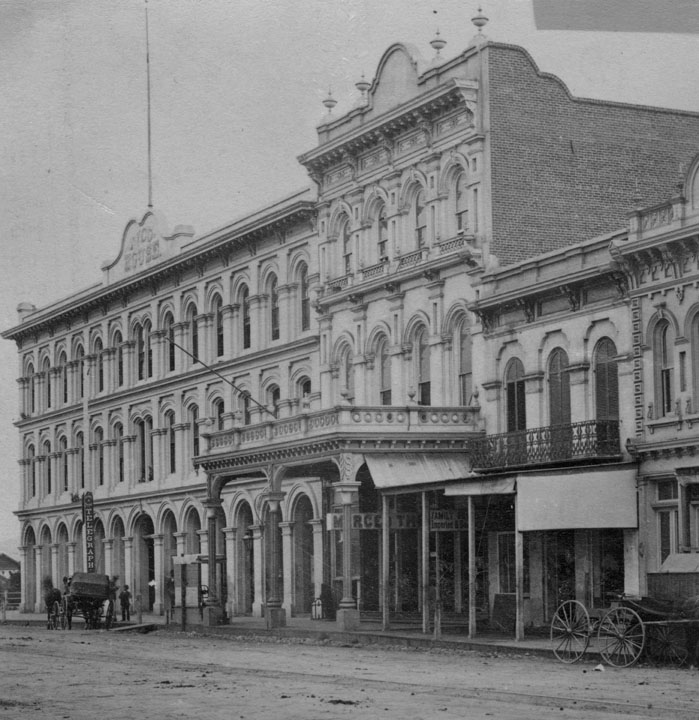
| (ca. 1873)** - View looking east showing the showing the Pico House, the Merced Theater, and the Masonic Lodge, located on Main Street. Two tanks of the City's first gas works are seen in the foreground. They were located just south of the Plaza Church (out of view to the left) and across the street from the Pico House. |
Historical Notes The gas tanks were built in 1867 when the City installed its first streetlighting system consisting of 43 gas lamps along Main Street. By 1873, 136 gas lamps provided the outdoor night lighting for the City. Things would change in 1882 when electricity was introduced. Click HERE to see more in Early Los Angeles Streetlights. |
 |
|
| (ca. 1870s)*#^ - Close-up view of the Pico House and surrounding area, including gas tanks in the foreground. |
 |
|
| (1873)*#^ - The Pico House, and to its right, Merced Theater and Masonic Lodge as seen from Fort Moore Hill. Note the streetcar tracks running down the middle of Main Street. Also, to the left, a fragment of the Plaza, and the adobe structures which stand south of the Lugo Adobe on what is now Los Angeles Street, then Calle de los Negros. The LA River can be seen in the background. |
 |
|
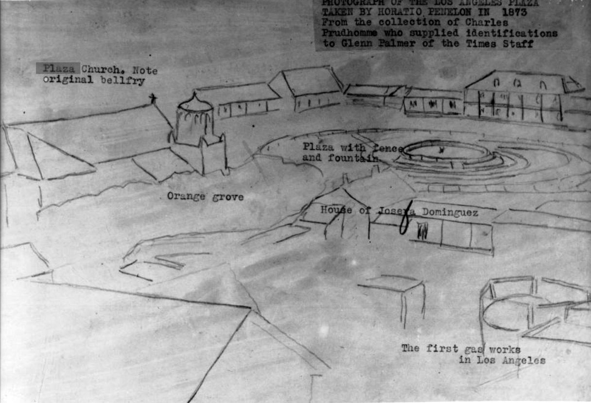
| (1873)*** - Photograph of a line drawing of the Los Angeles Plaza representing a photo by Horation Penelon. The plaza and fountain are shown to the right of center, the Josefa Dominguez home represented in front of it. The plaza church is shown to the left, while in the right bottom corner, the first Los Angeles Gas Works is depicted. |
Historical Notes A caption above the image reads: "Photograph of the Los Angeles Plaza taken by Horatio Penelon in 1873. From the collection of Charles Prudhomme who supplied identifications to Glenn Palmer of the Times Staff". The back of the photoprint identifies the structures pictured from left to right: (top) Nuestra Senora la Reina de Los Angeles "Plaza Church" ([...]berela Belfry); Jonas Jones home, ancestor of the Lankershim family; Judge Augustin Olveras, Home and Court Room; Pablo dor(?) Narvaros Adobe; Becente Luego Home, later Saint Vincentia College now Loyola; Don Ignacio del Valle home. Bottom: Plaza Church's campo Santo (cemetary); First Gas Works and Adobe of Dona [B]enancia Dotello de Dominguez. Photoprint also reads "Padre Blas Ra[...] in 1860 on the restoration of the chruch was the pastor". *** |
 |
|
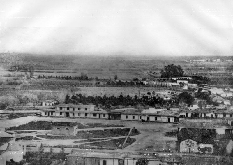
| (1873)** - A view of the Los Angeles Plaza as it looked in 1873. Again, note that the big water tank reservoir in the middle of the Plaza is no longer there. It was replaced with a fountain by the LA Water Company. |
Historical Notes In 1868, John S. Griffen, Solomon Lazard, and Prudent Beaudry, three of the city's more successful businessmen, submitted a proposal to the city council to develop and operate the city's water system. In turn they asked for all of the city's water rights and control over the water rates. They also promised to construct a reservoir for the city, lay twelve miles of iron pipe, install fire hydrants at major street crossings, provide free water to public buildings, and to erect an ornamental fountain in the Plaza. Click HERE to see more in Water in Early Los Angeles. |
.jpg) |
|
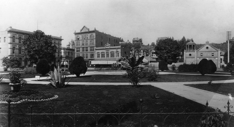
| (ca. 1873)** - View across the Plaza in the early 1870's were three people are posing for the photograph. The Plaza Church and the Cape House Restaurant are seen in the background. In the far background can be seen Fort Moore Hill. The Plaza was landscaped in 1871 and has served since that date as a public park. |
Historical Notes Fort Hill (also known as Fort Moore Hill) was a prominent hill overlooking the pueblo of Los Angeles. Its commanding view of the city made it a strategic location. Fort Moore was an historic U.S. Military Fort during the Mexican–American War. Its approximate location was at what is now the Hollywood Freeway near the intersection of North Hill Street and West Cesar Chavez Avenue, downtown. The hill on which it was built became known as Fort Moore Hill, most of which was removed in 1949 for construction of the freeway. The hill was located one block north of Temple Street and a short distance south of present day Cesar Chavez Avenue, between the Los Angeles Civic Center and Chinatown. The fort is now memorialized by the Fort Moore Pioneer Memorial, 451 North Hill Street.* |
 |
|
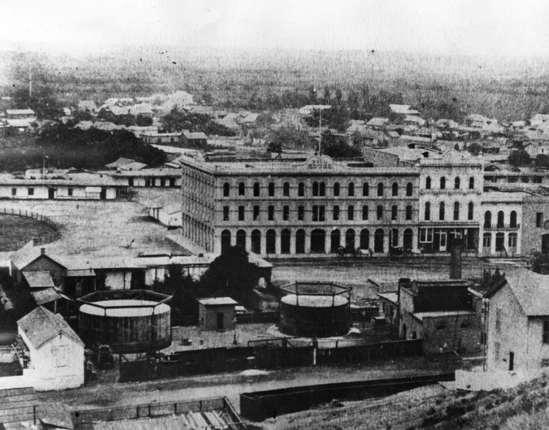
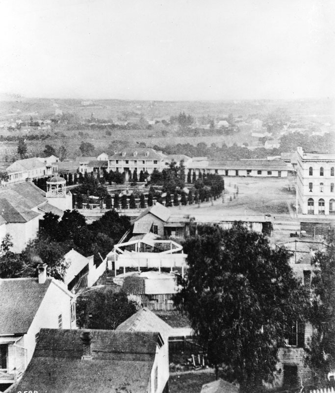
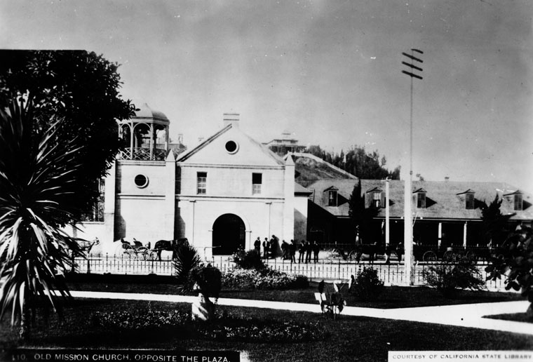
| (ca. 1875)* - Another view of the LA Plaza from a slightly different angle as seen from Fort Moore Hill. The Pico House can be seen to the right of the photo. To the left is the Plaza Church and next to it, at center of photo, are the City's gas works and tanks. |
 |
|
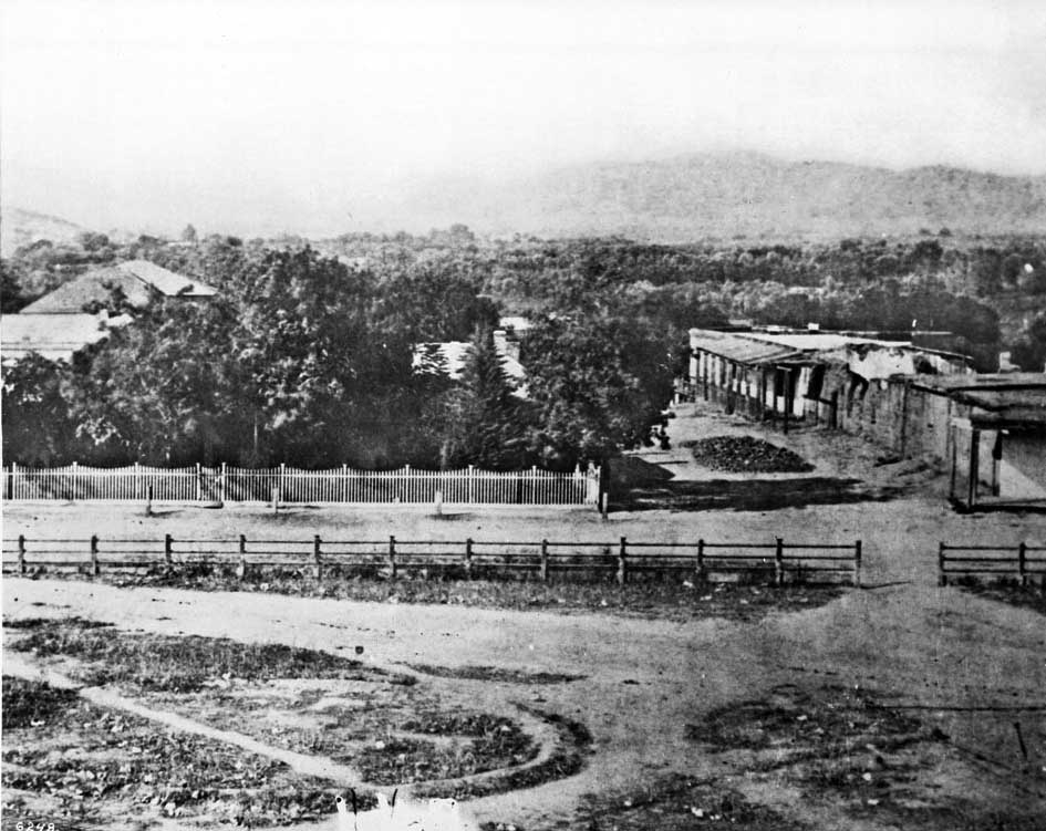
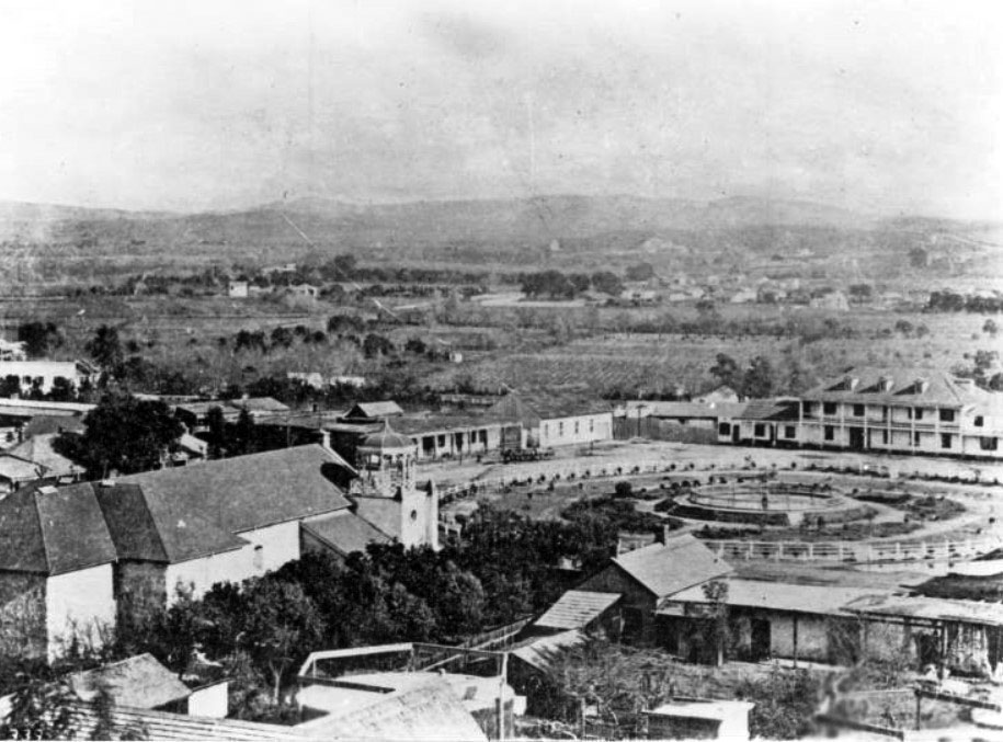
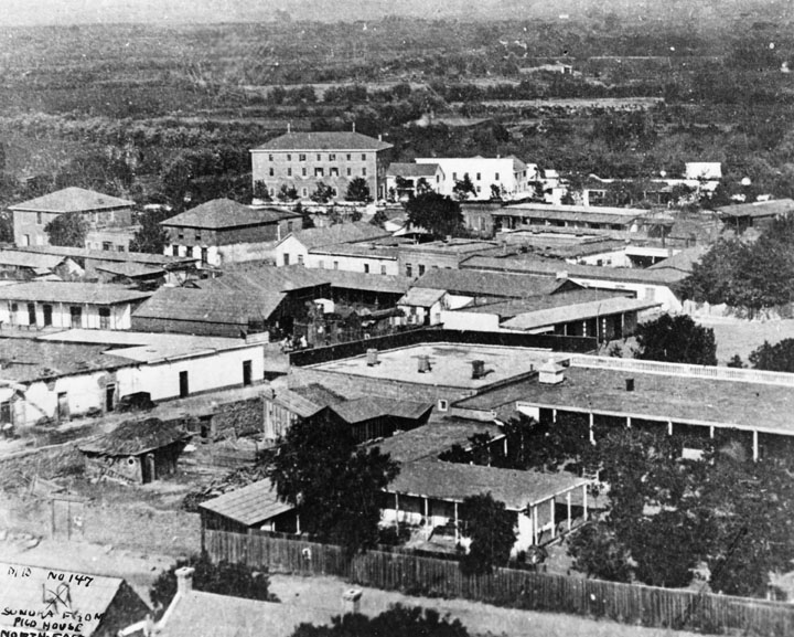
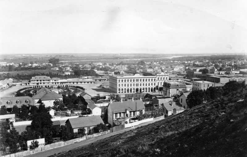
| (1875)** - Panoramic view of Sonora Town as seen from the Pico House in the 1870s. The large 3-story building in the background is the Los Angeles Charitable Institute run by the Sisters of Charity. |
Historical Notes In the foreground of the above photo is the courtyard of Nuestra Senora la Reina de Los Angeles, showing the padres' kitchen, bishop and padres' quarters, parochial school and courtyard planted to citrus orchard. To the left of this, a low white adobe, is the bakery of Pierre Domegue and his Indian wife, who baked sourdough French bread. Behind this on the next block are two square buildings, the Bath Street (later Olvera Street) Public School. In the rear is a three-story building at Alameda and Macy Streets, the Los Angeles Charitable Institute run by the Sisters of Charity. Just behind the bakery is the Pelanconi Winery, later La Golondrina Restaurant. Also shown, behind the church facilities, is the adobe residence of Mr. and Mrs. John Jones, parents of Mrs. Lankershim.** |
 |
|
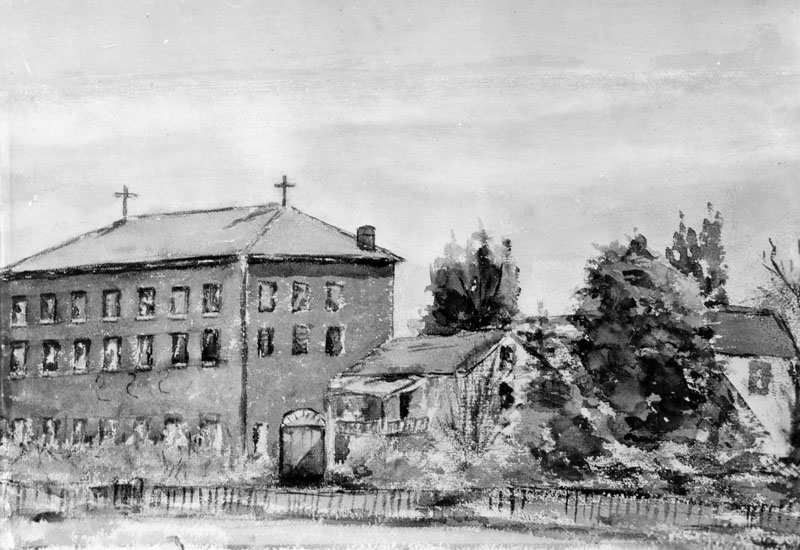
| (1860)** - Photo of a watercolor painting of the first school (and Sisters of Charity Orphanage) in Los Angeles, made in 1860 by a student. |
Historical Notes The school faced Alameda at Macy Street. It was called Los Angeles Charitable Institute, later the Los Angeles Orphan Asylum, but in Spanish, Casa de las Hermanas. The Sisters bought the old Benito Wilson frame house at the right, which had been shipped in pieces around the Horn. The property included about twelve acres and sold for $8,000. The house was demolished, and the brick building constructed with materials also brought around the Horn in a sailing vessel. The sale took place in 1856, the building was completed in 1858, and it was used until 1891. It opened with about 20 girls enrolled. Don Francisco Coronel (father of Don Antonio Coronel) and his two daughters were the teachers. One daughter later married the historian Bancroft. Later this became the site of the Post Office.** |
 |
|
| (ca. 1885)* - The Plaza as seen from the Pico House. The street on the left is Main Street and Los Angeles Street is on the right. Olvera Street can be seen in the upper center where it intersects with Marchessault Street. Sisters of Charity Orphanage can also be seen in the distance. John R. Putnam and Carlton O. Valentine Collection, California State Historical Society. |
Historical Notes The Pico House was built in 1868. |
 |
|
| (1876)** - Panoramic view of the Los Angeles Plaza on a very clear day. The Pico House is the prominent 3-story white building at the center of the photo. To its right stands the Merced Theatre. The LA River can be seen in the background. |
Historical Notes Pío Pico constructed the Pico House in 1868-70. The first three-story hotel built in Los Angeles, it had about eighty rooms, large windows, a grand staircase, and a small interior courtyard.^* |
 |
|
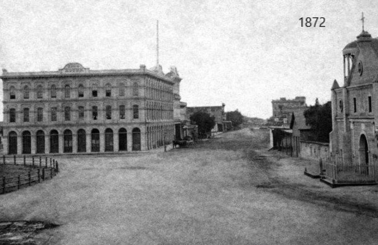
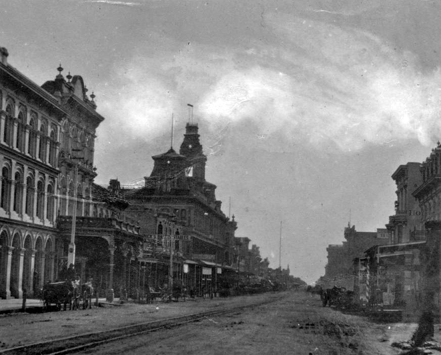
| (1872)* - Looking south on North Main Street from in front of the Los Angeles Plaza and the Old Plaza Church showing the Pico House and, behind it, the Merced Theatre. In the distance can be seen the Temple Block where today's City Hall Stands. |
Historical Notes Click HERE to see a Then and Now comparison of the above scene. |
 |
|
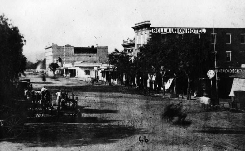
| (ca. 1870)* - Early view of the 300 block of North Main Street and beyond (view is looking North). Two large buildings stand out; the Pico House on the left and the Bella Union Hotel on the right. The Pico House is located one block north, across the street from the Los Angeles Plaza. It was built in 1870 by Pio Pico, the last Governor of Alta California under Mexican rule. Click HERE to see a Then and Now comparison of the above scene. |
Historical Notes The 300 block of North Main Street was an important part of Los Angeles history as early as the mid-1800s. It was considered the uptown commercial heart of the old city and was always buzzing with activity. Built there was Los Angeles’ first hotel, the Bella Union, which was long a social and political center. The first county courthouse was in the adobe hotel, where court was held in rented rooms from 1850 to 1852. Beginning in 1858, it was the region's transportation hub. The Overland Mail Company operated by John Butterfield (the founder of American Express) rented space for a station. The Wells, Fargo and Company also had their office here and Phineas Banning operated coaches to Wilmington and San Bernardino from the hotel. Just north of the two-story Bella Union was the Pico Building, built by Pio Pico in 1868 (two years before the Pico House). In 1871, the building became home to the Farmers & Merchants Bank, the first incorporated bank in Los Angeles. |
 |
|
| (1875)** - View of the Pico House, built by Pio Pico. There is a stage coach in front of the hotel and a horse drawn-carriage parked along side it. Approximately two dozen men seem to be standing on the sidewalk looking toward the photographer. |
Historical Notes In 1880, Pio Pico would lose the hotel by foreclosure. Also, between 1892 and 1920, the hotel would be known as the National Hotel.^#^ The Pico House (Hotel) was designated as California Historical Landmark No. 159. Click HERE to see California Historical Landmarks in LA. |
 |
|
| (1870s)** - The Merced Theater sits between the Pico House and the Mason Lodge. This was the "first business block on Main Street". |
Historical Notes The Merced Theatre, erected in 1870 on North Main Street next to the Pico House, was the first building built expressly for theatrical purposes in Los Angeles. It was built by William Abbot, a cabinetmaker, and named in honor of his wife Merced Garcia.^^ The theater was built in an Italianate style and operated as a live theater from 1871 to 1876. When the Woods Opera House opened nearby in 1876, the Merced ceased being the city's leading theater. Eventually, it gained an "unenviable reputation" because of "the disreputable dances staged there, and was finally closed by the authorities." ^* The Merced Theatre was dedicated as California Historical Landmark No. 171 (Click HERE to see more in California Historical Landmarks in Los Angeles). |
 |
|
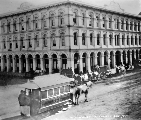
| (1874)*** - A horse-drawn streetcar of the Spring & Sixth Railway in front of the Pico House (Note: the photo indicates 1870, however, that date does not align with historic records indicating first streetcar in 1874). |
Historical Notes L.A.'s first streetcars ran under horsepower. Steam locomotives were considered too dirty and dangerous for use on city streets still teeming with easily spooked horses, and cable car technology was still new and expensive. Electric-powered traction railways, meanwhile, remained more than a decade off. On July 1, 1874, the modest, horse-drawn cars of the Spring and Sixth Street Railroad became the first streetcars to roll down Los Angeles streets. Founded by lawyer Robert M. Widney, the Spring & Sixth operated a regular schedule, running cars hourly on weekdays between 6:30 a.m. and 10 p.m. For a ten-cent fare, passengers could ride the one-and-a-half-mile route from the intersection of Temple and Spring south to Sixth, and then west to Figueroa. Soon, L.A.'s streetcar network expanded as new railways opened and existing lines extended their tracks across the city. The Plaza functioned as a central hub for the city's growing streetcar network, with lines radiating out in several directions.*^^* |
 |
|
| (ca. 1877)^## – View looking southeast toward the Pico House with the LA Plaza on the left. Streetcar rails are seen on the dirt road. Note the gas street lamp on the left. |
Historical Notes In 1867, Los Angeles saw its first street gas lamps. A total of 43 were installed along Main Street. A lamplighter on horseback rode down the street at dusk to light the streetlights. By 1873, about 136 gas lamps provided the outdoor night lighting for the City. Things would change in 1882 when electricity was introduced. That year 3,000-candle power arc lamps were lifted atop seven 150-foot poles. The state of the art at that time encouraged the use of a few tall standards with high illumination. The gas street lamps would see their last days.^ Click HERE to see more in Early Los Angeles Streetlights. |
 |
|
| (ca. 1877)** - The Pico House, sometimes called "Old Pico House", built by Pio Pico in 1869-70. Seen here from the Main St. entrance of the Plaza. The road in front and to the side of the building is dirt, and a set of tracks runs down the middle. The railway tracks were part of the East L.A. and San Pedro Street Railway. (Same as above but shows a portion of Main Street). |
Historical Notes The East Los Angeles & San Pedro Railway Company was founded by Judge Robert M. Widney (also one of the founders of the University of Southern California), this line was incorporated on May 1, 1875 but did not begin construction until March 1876. This horse car driven system ran north from Fourth Street and was intended to lay track to the new Southern Pacific depot. It reached only to College Street and North Broadway.^^^ |
 |
|
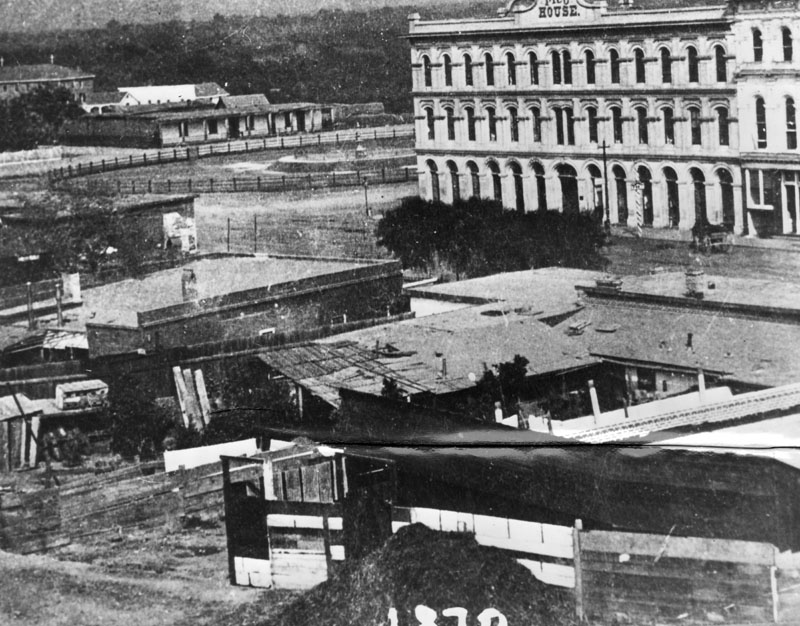
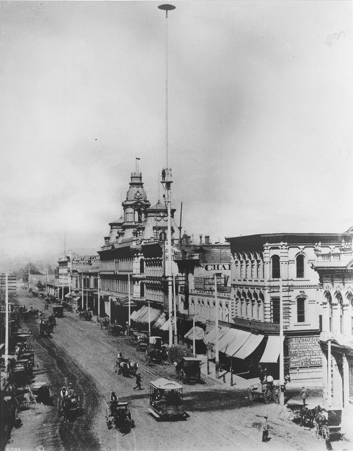
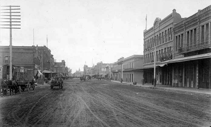
| (ca. 1878)*** - View of Main Street looking south. A horse-drawn wagon with two men in it is parked in front of the Pico House near the Merced Theatre on the left. The road is unpaved and a streetcar track runs down the middle. Both sides of the street are lined with imposingly large buildings. At center on the left side of the street is an especially big building topped by three prominent towers (Baker Block ). Most of the other buildings are somewhat Romanesque, with large columns and archways dominating their facades. Click HERE to see more in Early Views of the Historic 300 Block of N. Main Street |
 |
|
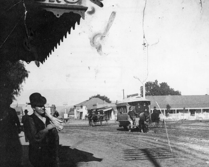
| (1882)** - Man with a hat stands gazing across the Los Angeles Plaza. To the right of the picture, is a horse-drawn trolley and buggy. |
Historical Notes Horse-drawn trolleys were the first form of public transportation to take passengers to and from the Plaza (1874-1887). In 1887 electic power streetcars started to take over. |
 |
|
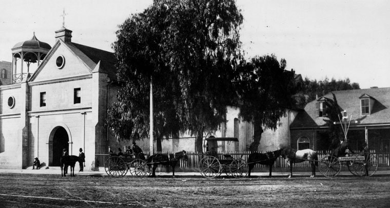
| (1880)** - Panoramic view of the Plaza Church showing one horse and several horse-drawn wagons "parked" along the street. |
 |
|
| (ca. 1880)*** - View of Calle Principal (now Main Street) showing the Plaza Church on the left and the LA Plaza on the right, as seen from the Pico House. Bath Street is on the right running up, away from the Plaza. |
 |
|
| (ca. 1880)*** - View of Calle Principal (now Main Street) showing the Plaza Church on the left and the LA Plaza on the right, as seen from the Pico House. Bath Street is on the right running up, away from the Plaza. Image enhancement and colorization by Richard Holoff. |
 |
|
| (1880)*#^ - Looking west across the Plaza towards the Pico House Main Street façade. |
 |
|
| (1882)*** - View of the Los Angeles Plaza and Sonora Town looking northeast from the Pico House, April 1882. |
Calle de Los Negros
 |
|
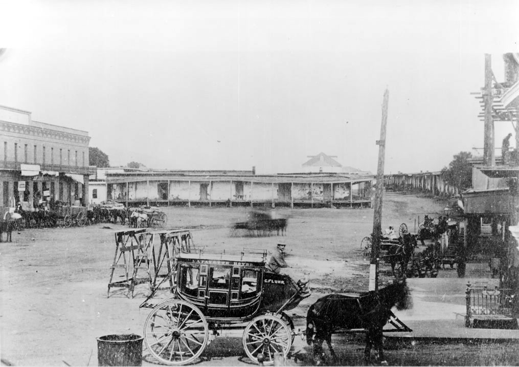
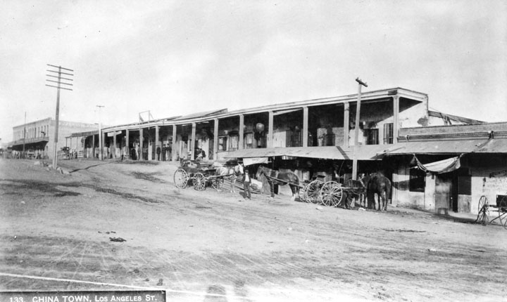
| (1870s)^^ - Lafayette Hotel stagecoach near the adobes in Calle de los Negros, presently Los Angeles Street and Arcadia Street. The old Antonio Coronel adobe is in the background. Numerous horse-drawn wagons and carriages are parked along the street. The above area was the scene of a Chinese massacre in 1871. |
Historical Notes The stagecoach in the foreground was owned by the Lafayette Hotel, the second Los Angeles hotel (after the Bella Union), owned by C. Fluhr (Fleubul?). Calle de los Negros is at the extreme right of the image and ran north from Los Angeles Street toward Aliso Street, ending where Dr. Gelsich had an apothecary shop. The two story brick building at the extreme left corner, on Arcadia Street, was occupied mainly by Caswell and Ellis grocers (or General Merchandise store of Harris Newmark?). In the corner was a saloon run by Marjett. He sold the first 5-cent beer. Marjett also owned a ranch in Antelope Valley to which the name of "Cinco Centavos" was given on account of his 5-cent beer. A son of Marjett later lived in Ocean Park. The open space in the foreground of the image is the end of Los Angeles Street. The hat on the stagecoach driver is a typical French cap of the time.^ |
 |
|
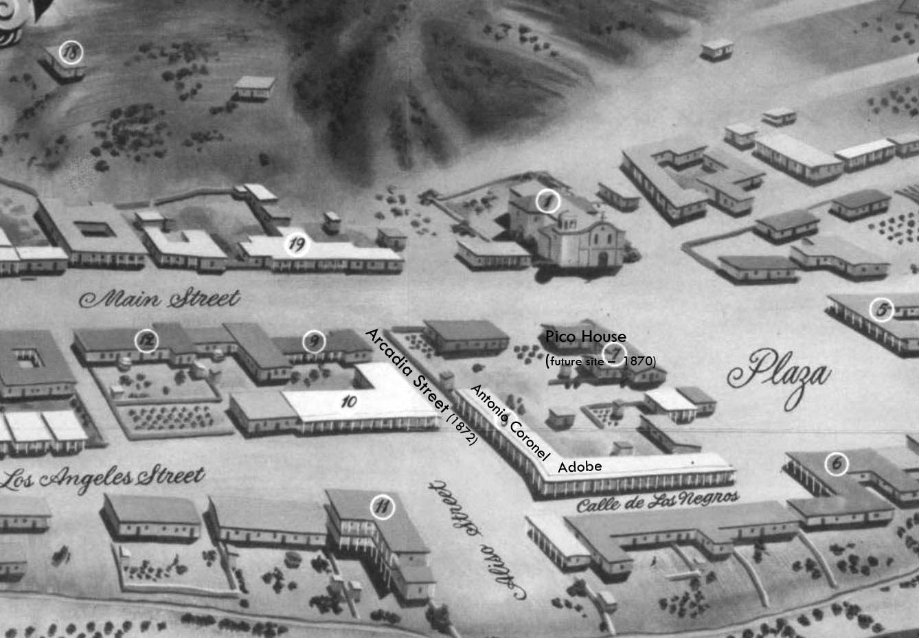
| (1850)^** - Map view looking northwest showing the LA Plaza and surrounding area as it appeared in 1850. The intersection of Aliso Street (later Arcadia) and Calle de Los Negros is seen at lower center-right with the Antonio Coronel Adobe on the northwest corner. |
Historical Notes The Pico House (center-right) wasn't built until 1870. The section of Aliso Street seen above was renamed Arcadia Street in 1872. |
 |
|
| (ca. 1870s)^- Closer view of the Coronel adobe with its covered sidewalk, located on the northwest corner of Arcadia Street and Calle de Los Negros (later Los Angeles Street). The back part of the Pico House (built in 1870) across Sanchez Street is on the left and the LA Plaza (out of view) is at center-right. |
Historical Notes Antonio F. Coronel, was a state treasurer and former Los Angeles mayor who owned the main block of rundown adobe stores and apartments in this area. The Coronel house was the scene of the beginning of the Chinese massacre of 1871. #^#^ Once home to the town’s most prominent families, the neighborhood had deteriorated into a slum by the time Los Angeles’s first Chinatown was established there in the 1860s.*^ |
.jpg) |
|
| (ca. 1882)^ - View of Calle de los Negros. On the left is the adobe of Antonio Coronel; behind the adobe and with belltower is the Plaza Firehouse; center with a gable roof is the Vincent Lugo Adobe (facing the plaza on Los Angeles Street); and right with columns is the Antonio Maria Lugo adobe, which he willed to his son, Dolores del Carmen Lugo. View is looking toward the plaza from the east. |
Historical Notes There was no area more colorful than Los Angeles’s Calle de los Negros, a short dirt thoroughfare located just off the eastern edge of the historic Plaza and considered to be the center of the town’s “red light” district. Saloons, gambling dens, brothels, and other entertainment venues were said to proliferate on the Calle; the same could also be said for crime.**^ |
 |
|
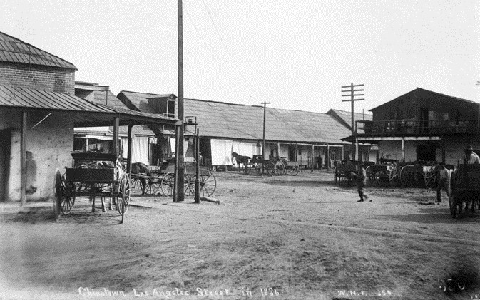
| (1886)^ - View of "Calle de los Negros," which became part of Los Angeles Street. |
Historical Notes Los Angeles Street was first named in 1854. Before the first official survey of the area in 1849, most of this thoroughfare was called Calle Principal (Main Street). Other sections were known as Calle de la Zanja (Ditch Street), Calle de Los Vinas (Vineyard Street) and--much to the south--Calle de los Huertos (Orchard Street), which is now San Pedro Street. These formed the principal highway running south to the Embarcadero of San Pedro. At its northern end, near the Plaza, a 500-foot stretch was known as Calle de Los Negros, which had a racially diverse population.^*^ |
 |
|
| (ca. 1882)#^ - View of Calle de los Negros, one of the roughest streets in town. The tower of the Old Plaza Firehouse can be seen in the background. This was Chinatown’s center when eighteen Chinese imigrants were massacred in 1871. |
Historical Notes The Chinese massacre of 1871 was a racially motivated riot on October 24, 1871 in Los Angeles, when a mob of over 500 men entered Chinatown to attack, rob and murder Chinese residents of the city. The riots took place on Calle de los Negros (Street of the Negroes), also referred to as "Nigger Alley", which later became part of Los Angeles Street. A total of 18 Chinese immigrants were systematically killed by the mob, making the so-called "Chinatown War" the largest incident of mass lynching in American history.*^ |
 |
|
| (ca. 1886)^ - View of Calle de los Negros, running south of the Plaza along what is now the east side of Los Angeles Street. |
Historical Notes Calle de los Negros was situated immediately northeast of Los Angeles’s principal business district, running 500 feet from the intersection of Arcadia Street to the Plaza. The unpaved street took its name from the dark-complexioned Californios (pre-annexation, Spanish-speaking mixed-race Californians) who had originally lived there.*^ |
 |
|
| (1886)^^ - View looking east from Aliso Street at the entrance to "the alley". |
Historical Notes In 1886, the extension of Los Angeles Street eliminated the alley and today the site adjoins the Hollywood Freeway. |
 |
|
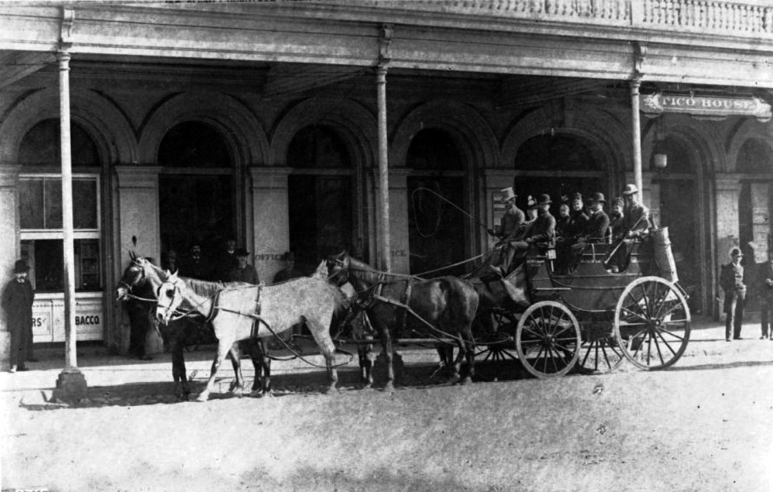
| (ca. 1884)*** - View showing a stagecoach (or Tally-ho) parked in front of the Pico House. Nine people sit in the uncovered stagecoach. The driver holds a whip over the hitched team of 4 horses. Nine other people stand on the boardwalk in front of Pico House looking on. |
 |
|
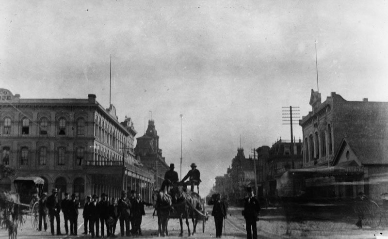
| (1883)** - View looking south on Main Street showing a group of men standing next to a horse-drawn wagon with two men seated on top. The Plaza is on the left (out of view). In the left background stands the Pico House and the Baker Block with its distinctive towers. There is a very tall pole seen between the two men on the wagon which appears to be a flagpole, but is not. It is a 150-foot tall electric street light mast that was one of the first to be installed in the City of Los Angeles. |
 |
|
| (ca. 1882)** - View looking toward the Baker Block on the east side of Main Street north of Commercial Street showing one of the first of seven electric street lights installed in the City of Los Angeles in 1882. It stood 150 feet tall! A man can be seen standing on a platform half way up the street light mast. |
Click HERE to see more in Early Los Angeles Streetlights |
 |
|
| (ca. 1884)** - Photograph showing Los Angeles' first fire station, near the Los Angeles Plaza, with a horse and buggy firefighting team (The First Volunteer Company), located at 26 Plaza Street. |
Historical Notes The Old Plaza Firehouse is the oldest firehouse in Los Angeles. Built in 1884, it operated as a firehouse until 1897. The building was thereafter used as a saloon, cigar store, poolroom, "seedy hotel", Chinese market, "flop house", and drugstore. The building was restored in the 1950s and opened as a firefighting museum in 1960.^* For the first two years of its existence the station housed 38's Engine Company No.1 (comprised of 38 volunteers, a horse cart and 3 horses). The volunteer fire companies also used the area to stage the parades, holiday fireworks displays, monthly inspections and periodic musters which helped to stimulate civic pride. This and the fact that the volunteers continually bickered amongst themselves and some of the companies acted in too independent a fashion, led to the establishment, in December 1885, of the city's first paid Fire Department. The council appointed Walter S. Moore as Fire Chief and the new Board of Fire Commissioners installed another steam engine company (Walter S. Moore Company No. 4) at the Plaza Firehouse with a seven man crew while the Volunteer 38's moved elsewhere or disbanded.*^ The Old Plaza Firehouse was dedicated as California Historical Landmark No. 730. Click HERE to see the complete list of California Historical Landmarks in L.A. |
 |
|
| (ca. 1885)*** - Panoramic view of the Plaza Church from the north end of the Plaza. Carriages, people and pepper tree in foreground. A picket fence surrounds part of the property. Dwellings are visible on hill in background. |
Historical Notes The Old Plaza Church was the parish church for Los Angeles and was never a mission. |
.jpg) |
|
| (ca. 1885)*** - Panoramic front view of the Los Angeles Plaza Church. There is an open octagonal cupola on the church roof to the left of the cross at the roof ridge. An adjacent building and large tree are behind a wooden picket fence. The street is cobbled. |
 |
|
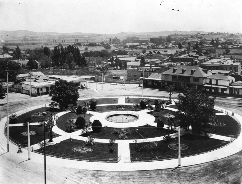
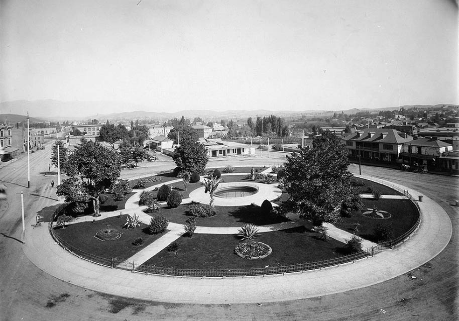
| (1886)** - Los Angeles Plaza in 1886, looking northeast. Olvera Street is at extreme left. Note the landscaping around the Plaza and the degree to which it has grown. |
 |
|
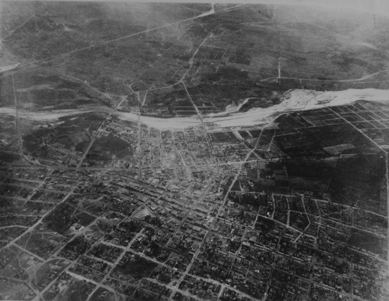
| (1887)** - Aerial photo of Los Angeles looking East on June 27, 1887 taken from a balloon. Note the farmland south of Second Street and east of Main Street to the Los Angeles River. The circular form of the Plaza is visible to the center left.^* |
Historical Notes Floating some 9,000 feet above the city in a hot-air balloon in 1887, Edwin H. Husher took what may be the first aerial photo of Los Angeles.^#^* By 1887 the City's population had grown to over 20,000 people with most of the new development having taken place south of the orignal Pueblo and LA Plaza as seen in the above photo. |
 |
|
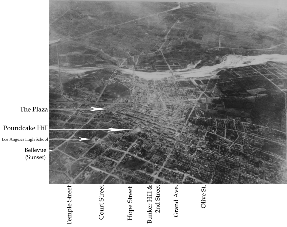
| (1887)** - Same photo as above but annotated to show the location of the Plaza and major streets. The circular form of the Plaza is visible to the center left. Note how the City has spread out mainly to the South of the Plaza. There is still a large area of farmland south of Second Street and east of Main Street to the Los Angeles River.^*# |
 |
|
| (ca. 1887)** - View showing one of Los Angeles' first electric streetcars approacthing the front of the Old Plaza Church. In the background can be seen the Banning House sitting on top of Fort Moore Hill. The Plaza functioned as a central hub for the city's growing streetcar network, with lines radiating out in several directions. |
Historical Notes In 1874, Los Angeles saw it's first streetcars which all ran under horsepower (horse-drawn trolleys). Things would change in 1887 when electric powered streetcars arrived. Charles H. Howland chartered the first electric streetcar company in Los Angeles, LA Electric Railroad Company, on September 11, 1886. It began operations on January 4, 1887 with the line opening from Pico Boulevard and Main Street traveling west to Harvard Boulevard. In 1896, many of the major horse and cable cars operating in Los Angeles converted to electrical power.^^^ It should be noted that Howland was also responsible for introducing the first elecric streetlights in Los Angeles (1882). Also, for starting the LA's first electric utility, Los Angeles Electric Comnpany (1883) which evolved into LA Gas and Electric Corporation and then finally absorbed by LADWP (1936). Click HERE to see more in Early Power Generation in Los Angeles. |
 |
|
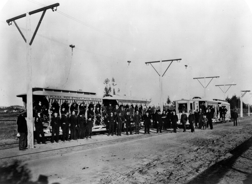
| (1887)*** - Photograph of an open-air car on the first electric railroad in Los Angeles from the Plaza to Pico Heights in 1887. Many men in fine suits and just several women in fine dresses pose in front of an open-air rail car at center. The cars whose sides read "Plaza, Pico Street, Pico Heights" are attached to wires that run above it. The ground around them is dusty and spotted with weeds. |
Historical Notes Started in 1887, the Los Angeles Electric Railway (LAERy) ran the first electric powered streetcars in Los Angeles. It, however, operated only intermittently and frequently one had to wait two hours for a car. Operation was discontinued in the Fall of 1888. In 1890 the LAERy Co. was acquired by the Electric Rapid Transit Company (ERT) which attempted to rebuild the lines and acquire new electric cars. Sixteen new cars were ordered, 10 motors and six trailers. When the cars arrived in Los Angeles the investors could not pay the freight bill and so turned to General Moses Sherman for help. For his $56,000 investment he received one-half interest in the ERT Co. By September 1st 1890 he had secured full ownership.^*^ Sherman was also responsible for constructing the electric railway into the San Fernando Valley in the early 1900s which played such an vital role in its development. Click HERE to see more in Early Views of the San Fernando Valley. |
 |
|
| (1886)**- The intersection of Bellevue Avenue and Buena Vista, looking southwest toward Fort Moore, when Los Angeles was a small town. Buena Vista Street was later renamed Broadway. The Banning House sits on top of Fort Moore Hill overlooking the Los Angeles Plaza. |
Historical Notes This section of Buena Vista is soon to be renamed Justicia running south from Bellevue, which would become Sunset and then ultimately become Cesar E. Chavez Avenue (which here runs diagonally across the bottom of the frame from the lower left corner to the right edge) to Temple. Buena Vista north of Bellevue would become N. Broadway. The Broadway tunnel is still fifteen years in the future, the north portal of which will exit the base of the hill behind these adobes. Mary Hollister Banning's house can be seen on the crest of the hill. It will overlook the north portal. #^* |
 |
|
| (ca. 1887)** - View of Fort Moore Hill, showing the home (upper center) of Mary Hollister Banning, widow of General Phineas Banning. Part of the trenches of old Fort Moore, built in 1846-1847, are visible in the upper left. |
Historical Notes The structure was built by Jacob Philippi as a beer hall, but Banning purchased and transformed it into a home.** |
.jpg) |
|
| (1888)** - Horses and buggies at the Los Angeles Plaza in 1888. The California Bakery is seen in the background, as well as a covered wagon advertising the Home Ice Company. A horse and buggy in the foreground advertises for Bluett & Sullivan at 1st and Spring streets. Fort Moore Hill can be seen in the background. |
 |
|
| (1888)* - A drawing showing Los Angeles in 1888, with the Los Angeles Plaza on the left, and the Pico House in the center. View is from Fort Moore Hill. |
 |
|
| (ca. 1880)** - View looking north on Main Street from the Downey Building located just south of the Baker Block on the 300 block of N. Main Street. In the distance can be seen the Plaza Church where Main Street veers to the left. Telephone/telgraph lines can be seen on both sides of the street. |
Historical Notes Alexander Graham Bell invented the telephone in the late 1870's and it didn't take long for Los Angeles to adopt the new technology. In 1879, the Los Angeles Telephone Company was formed and it began offering telephone service in the area of what is now Downtown Los Angeles. This was just one year after the very first North America telephone exchange was installed in New Haven, Connecticut (January, 1878). The Los Angeles Telephone Company originally started with only seven subscribers.^*^*^ |
 |
|
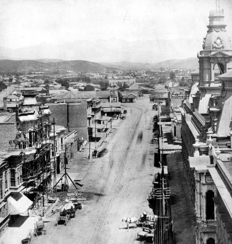
| (1880s)** - View looking south on Main Street from near the Pico House. Temple Block can be seen in the distance. A large number of people are on the sidewalks and quite a few horse-drawn vehichles are on the street. The population in Los Angeles had grown to 11, 200 by now. Telegraph/Telephone poles and wires are seen on both sides of the street. The wording 'SUNSET' can be read on one side of the pole to the left. |
Historical Notes In 1883, The Los Angeles Telephone Company merged with another local telephone company based in Northern California, Sunset Telephone Company. In 1906, the Sunset Telephone Company was acquired by Pacific Telephone and Telegraph, later known as Pacific Bell.^*^*^ |
 |
|
| (1888)^## – View looking south, showing the west side of the 300 block of Main Street as seen from the Pico House. A horse-drawn streetcar shares the street with pedestrians, horse-drawn wagons, and a man on horseback (center-left). Click HERE to see more in Early Views of the Historic 300 Block of N. Main Street |
 |
|
| (ca. 1903)** – View looking northwest showing the Olvera Adobe (converted to office space), on the north side of the Plaza, facing Marchessault St. Olvera Street is out of view, west of the adobe. Los Angeles St (running left to right in the foreground) is on the adobe's east side. The building behind the Olvera Adobe, with the stepped gable end, is a Pacific Electric Power Station. It was built in 1903. |
Historical Notes Agustín Olvera arrived from Mexico in 1834 where he had been a Justice of the Peace, and held various offices in the Mexican administration. In 1842 he was granted Rancho Mission Viejo, and three years later, was also granted the 35,501-acre Rancho Cuyamaca. Olvera is noted for helping to bridge the gap between the governance of California by Mexico and the U.S.; helping sign the Treaty of Cahuenga, thus ending the war in California; was appointed to be Judge of the First Instance in 1849; was elected as the first county judge of the newly formed County of Los Angeles in 1850; and eventually entered private practice law. In 1877, the Los Angeles City Council changed the name of Wine Street to Olvera Street in his honor. Marchessault Street is named for French Canadian, Damien Marchessault, who served as mayor of Los Angeles from 1859-1860, and again from 1861-1865. During his term in office, the Plaza Church was rebuilt and the City Gas Company was organized. Marchessault committed suicide in the city council chamber in 1868, after becoming despondent over public criticism of the water system and over gambling debts.** |
 |
|
| (1890)** - View looking north across the L.A. Plaza to the beginning of Olvera Street. The Olvera Adobe can be seen to the right on the northeast corner of Olvera and Marchessault streets. |
 |
|
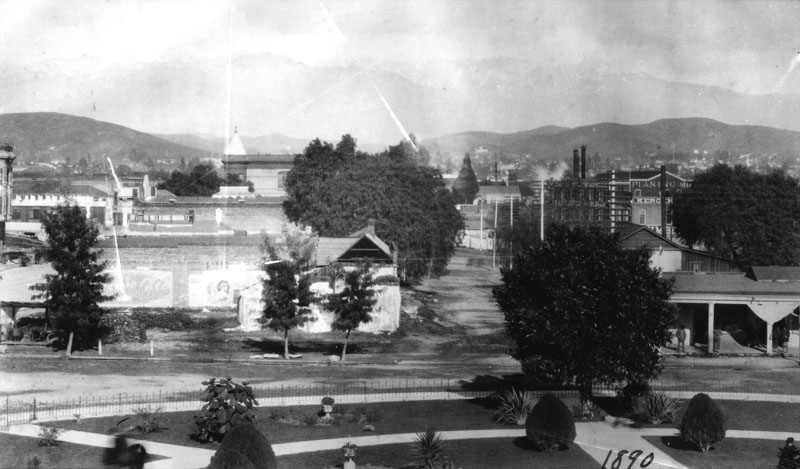
| (ca. 1890)* - The Los Angeles Plaza, around 1890. The one story building on the left is the former residence of Don Augustin Olvera. The large two story on the right is the former residence of Don Vicente Lugo. The LA City Water Company building is at the northwest corner of Marchessault and North Alameda (at the center of the photo). |
.jpg) |
|
| (ca. 1890)*** - View of the Plaza as seen from the Brunswig Building (slightly different angle as previous photo). The historic Lugo House faces the circular plaza. The Los Angeles Water Company building is also in view. |
 |
|
| (ca. 1890s)** - Exterior front view of the two-story Vicente Lugo adobe house, seen with hipped roof and dormer windows. The home is on S/E corner of Los Angeles and Alameda Streets, and faces the Plaza. When this photograph was taken, the adobe was home to Leeching Hung & Co., with adjacent buildings flanking it on either side; horse-drawn carriages are parked on the unpaved road in front of the buildings. |
Historical Notes The Lugo Adobe has been designated as a California Historical Landmark No. 301. Click HERE to see more in Early Views of California Histrorical Landmarks in L.A. |
 |
|
| (ca. 1887)* - A view of the Los Angeles Plaza looking southwest with the Pico House to the left and the Old Plaza Church on the right. The 2-story 'Plaza House' (built in 1883) sits directly across the Plaza on the west side of Main Street. The Vickrey-Brunswig Building, one of the City's first 5-story buildings, would be built within a year of this photo just to the left (south) of the Plaza Building. |
Historical Notes In 1887, during the height of the real estate boom, investor William Vickrey bought a parcel of land on North Main Street, on which he commissioned construction of the Vickrey-Brunswig Building. Originally the site of an adobe owned by Jesus Dominguez, the land was purchased by Vickrey from the City of Los Angeles for a total cost of $3,925. Los Angeles city directories from the mid-1880s list Vickrey's occupation as "capitalist." He established and served as president of the East Side Bank, which was located at 510 Downey Avenue in downtown Los Angeles.^^^^ |
 |
|
| (ca. 1890)** - Same view as previous photo but three years later. The new additon to the scene is the 5-story Vickrey-Brunswig Building built adjacent to the Plaza House. |
Historical Notes Construction of the Vickrey-Brunswig Building took place in 1888, the year marking the abrupt collapse of the real estate boom that had driven rapid construction and market speculation through the 1880s. Soon after completion of the building, Vickrey would be forced to declare insolvency and then lose the property to his lender.^^^ The Victorian-era brick Vickrey Building was among the earliest five-story buildings in Los Angeles. When it opened in 1888, the building housed ground floor retail with lodging on the upper floors. #*#* The two-story Plaza House (built in 1883) was commissioned by Frenchman Philippe Garnier, whose name appears at the base of the decorative false gable parapet rising above the roofline. It was once the site of La Esperanza Bakery. |
 |
|
| (ca. 1890s)** - Closer view showing the new 5-story Vickrey-Brunswig Building located on N. Main Street across from the LA Plaza and also across the street from the Pico House. Men are seen strolling in front of the Plaza. |
Historical Notes In 1897, the Vickrey Building was purchased by F. W. Braun and Company, and for more than three decades was associated with the pharmaceutical industry. Reorganized as the Brunswig Drug Company in 1907 following its purchase by part owner and prominent Angeleno Lucien Brunswig, the company expanded dramatically and developed into the largest pharmaceutical manufacturing laboratories west of Chicago. #*#* |
Then and Now
 |
|
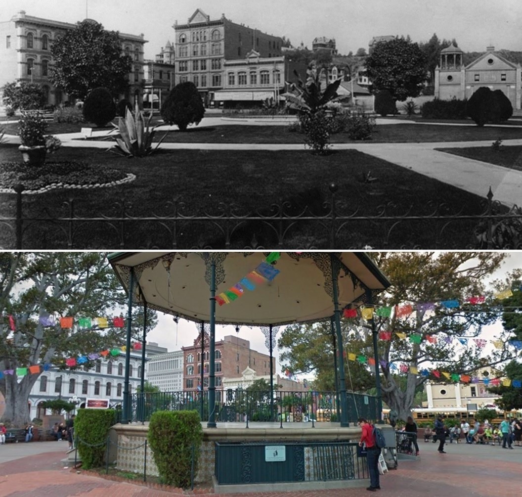
| (1890 vs 2022)* – Looking across the LA Plaza toward (L to R): Pico House, Vickrey-Brunswig Building, Plaza House and the Old Plaza Church. |
 |
|
| (ca. 1890)** - Panoramic view of the Old Plaza Church, the plaza, and Sonora Town, looking northeast. The house opposite the church on the other side of the plaza is the adobe of Vincent Lugo on Los Angeles Street. The Los Angeles City Water Company building can also be seen. |
Historical Notes The part of the city called Sonora Town was an old adobe village north of the Plaza and Church of Our Lady, Queen of the Angels. It was Los Angeles' first Mexican quarters, or barrio. The area was named for the numerous miners and families who came from Sonora, Mexico, and may have still been around in the 1930s. Now it is Los Angeles' Chinatown District.^ |
 |
|
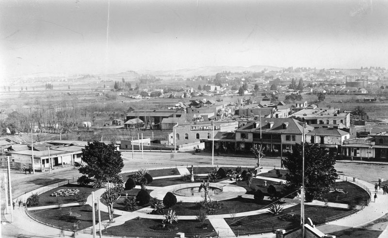
| (ca. 1892)**- Aerial view of the Los Angeles Plaza, circa 1892. The adobe to the left is the former residence and occasional courtroom of Judge Augustin Olvera. The large two-story building on the right is the former residence of Don Vicente Lugo and the first home of St. Vincent's College. The Los Angeles City Water Company has a painted sign, and is visible on the northwest corner of Marchessault and North Alameda Street. |
Historical Notes In 1868, the City of Los Angeles approved a franchise water agreement on a 30 year lease basis with the private Los Angeles City Water Company. In 1899, after the end of the lease, a $2.09 million bond measure for the purchase of LA City Water Co.’s system was approved by city voters by a margin of nearly eight to one. After over two years of litigation the City of Los Angeles finally regained control of its water system on February 3, 1902. A new department was created called the Los Angeles Water Department. Once the purchase was completed, the Los Angeles City Water Department acquired all assets of the privately owned water system including its main office building at Marchessault and North Alameda. Click HERE to see more in Water Department's Original Office Building. |
 |
|
| (ca. 1892)#*^ - View of the LA Plaza as seen from the Pico House. |
.jpg) |
|
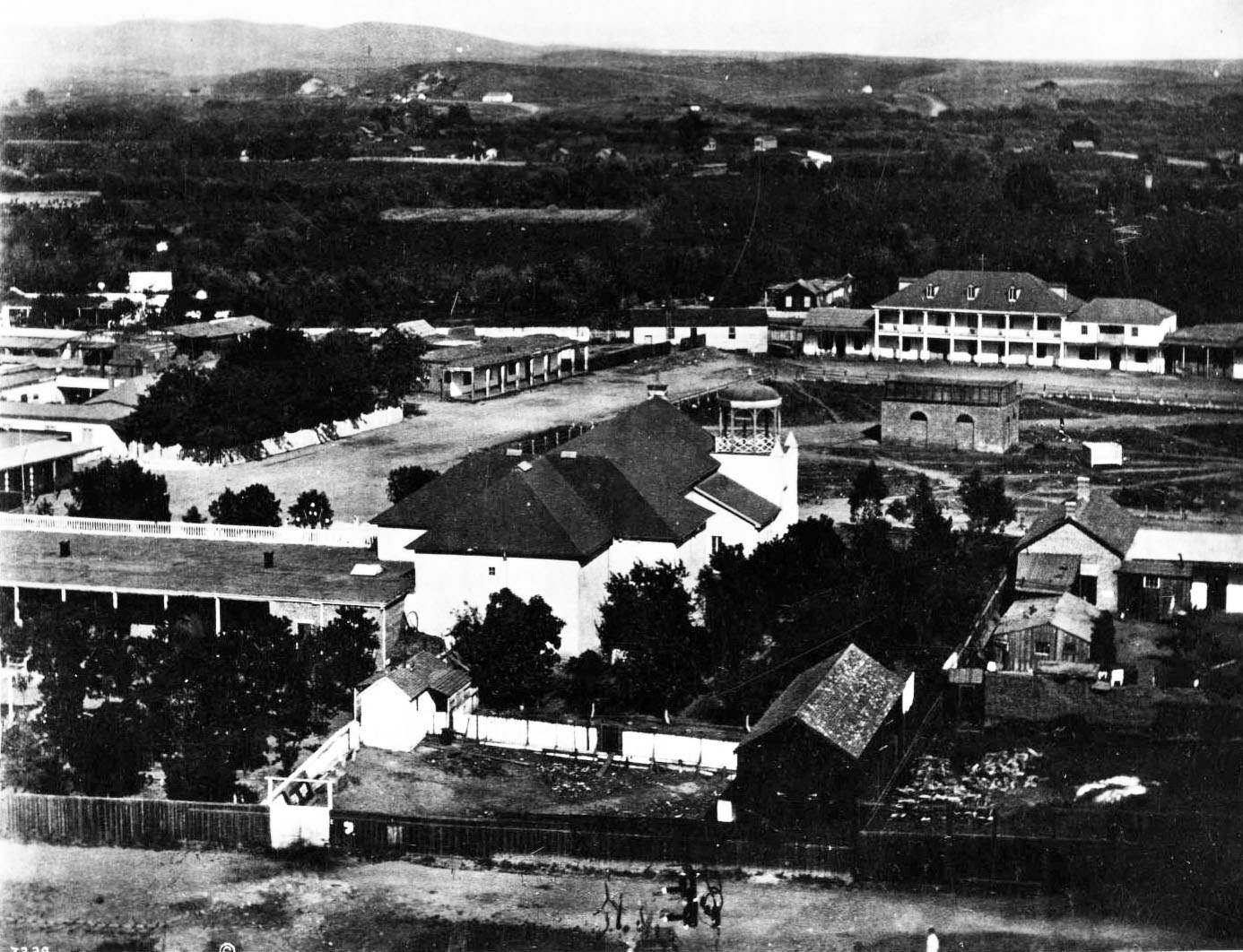
| (ca. 1892)** - On the left is the Pico House, the Plaza Church in the center. Fort Hill appears in the background, with residences of William Wills, and Mrs. Phineas Banning, and the tower of Los Angeles High School. |
 |
|
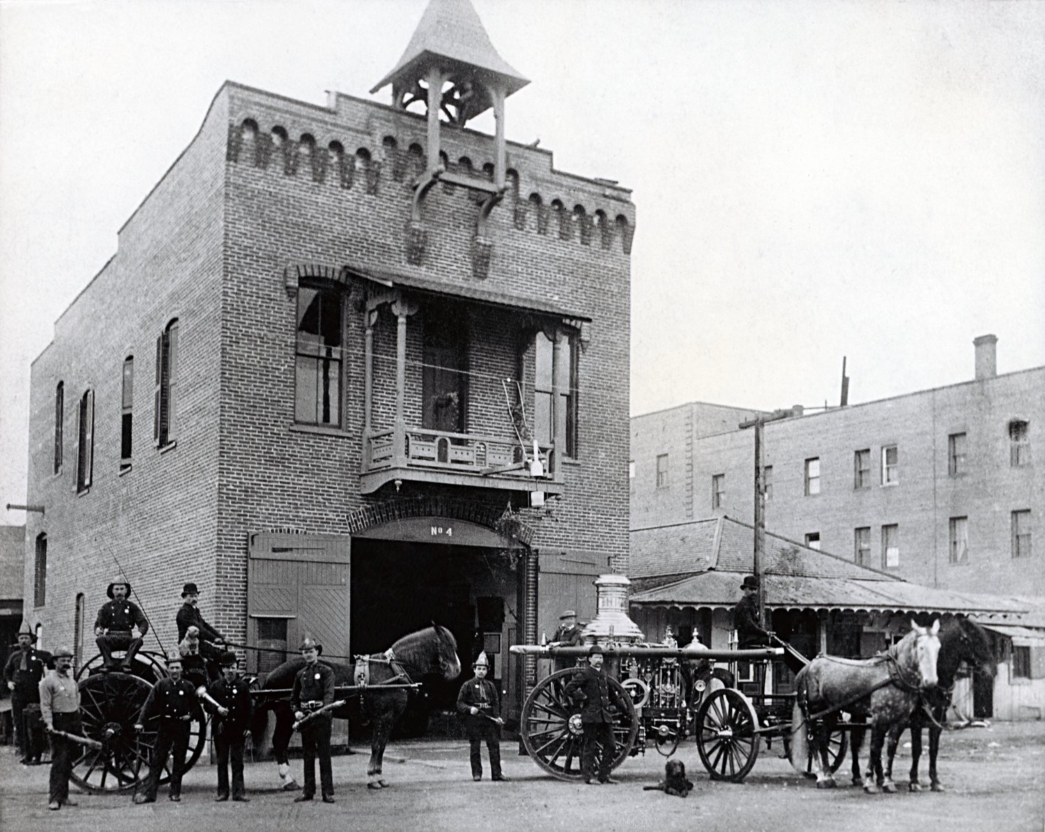
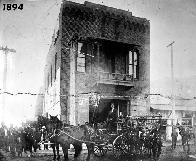
| (1894)*#^ - Firetruck, men and horses in front of the Plaza Firehouse. To the right stands Governor Pio Pico's office. |
Historical Notes The Old Plaza Firehouse is the oldest firehouse in Los Angeles. Built in 1884, it operated as a firehouse until 1897. The building was thereafter used as a saloon, cigar store, poolroom, "seedy hotel", Chinese market, "flop house", and drugstore. The building was restored in the 1950s and opened as a firefighting museum in 1960.^* The Old Plaza Firehouse was dedicated as California Historical Landmark No. 730 (Click HERE to see more in California Historical Landmarks in L.A.) |
 |
|
| (1895)** - View of Governor Pio Pico's Office located between the Old Fire Station (left) and the Pico House (right), across from the Plaza. The prominent towers of the Baker Block can be seen in the background. |
 |
|
| (ca. 1894)^*^# – Several horse-drawn wagons are parked by utility poles in front of the Los Angeles Plaza Church. A woman is seen walking toward the LA Plaza. It appears the road is being rebuilt using bricks. Note the bakery sign next door to the church. |
 |
|
| (1894)** - Plaza Church as seen by looking north from Pico House on Main Street. This was the parish church for Los Angeles and was never a mission. A woman is seen holding a small child in front of the church. |
Historical Notes Mission Nuestra Señora Reina de los Angeles (Church of Our Lady the Queen of the Angels), was founded on September 4, 1781 by a group of Spanish settlers. The church was considered an asistencia ("sub-mission") of Mission San Gabriel Arcángel. Priests from Mission San Gabriel divided their time between the mission and the Asistencia site, but ultimately the installation was never granted mission status and the missionaries eventually abandoned the site. The surrounding area was named El Pueblo de Nuestra Señora la Reina de los Angeles del Río de Porciúncula ("The Town of Our Lady the Queen of the Angels on the River Porciúncula", which is the present-day City of Los Angeles). A chapel, La Iglesia de Nuestra Señora Reina de los Angeles, was later erected and dedicated on December 8, 1822, and for years served as the sole Roman Catholic church in the Pueblo. It is the oldest church in the city of Los Angeles. The Plaza Church was dedicated as California Historic Landmark No. 144. Click HERE to see list. |
 |
|
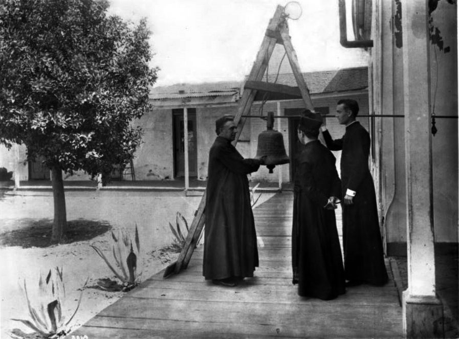
| (ca. 1890)*** - View showing Reverend Father Joachim Adam recounting the history of the old Mission bell to two other priests. The bell hangs from a long metal rod supported by a folding wooden ladder standing on a boardwalk on the Mission grounds. All three priests are wearing cassocks. Part of the exterior corridor of a one-story adobe building is visible behind the group. |
Historical Notes Back of photo print reads: "This bell (known as the Penance Bell) was given by Henry Delano Fitch as a forfeit for his transgression when he defied the civic and ecclesiastical authorities and eloped with Josefa Carillo, a Spanish California lady -- the first elopement of California -- 1829."*** |
| (ca. 1895)*##*- Men and women gather around the Plaza Church. The church is a stone block building with an arched doorway, ocular window, and a gazebo-like structure mounted on the roof. Shows the faint impressions of paintings on the exterior of the building. Signs on nearby commercial buildings read: "Saloon and Restaurant, Home Brewery" and "F.W. Braun and Co., Druggist." |
 |
|
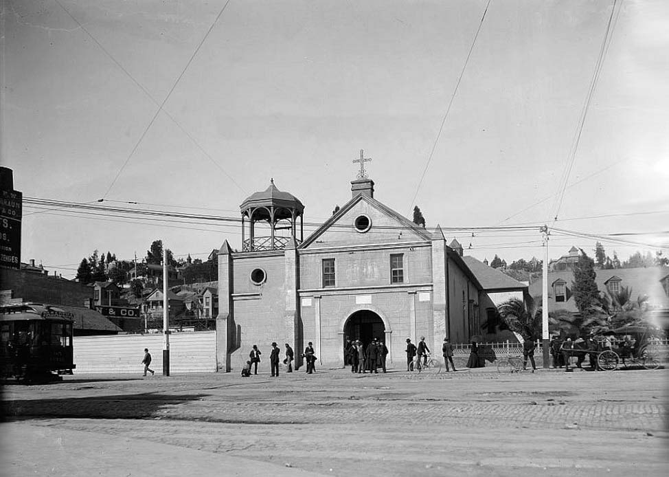
| (ca. 1895)#^* – Closer view showing the Plaza Church on what appears to be a Sunday as gentlemen seem to be dressed in their 'Sunday best', lots of details, a shoeshine boy works while his customer appears to enjoy a cigar, a man on a bicycle, another bike parked at the curb, a horse-drawn carriage, a streetcar bound for Pasadena, a lady gazing into the churchyard. |
 |
|
| (1898)** - View of the Old Mission Church looking from the plaza. Several horse-drawn vehicles are parked along the sidewalk. Fort Hill appears in the background. |
 |
|
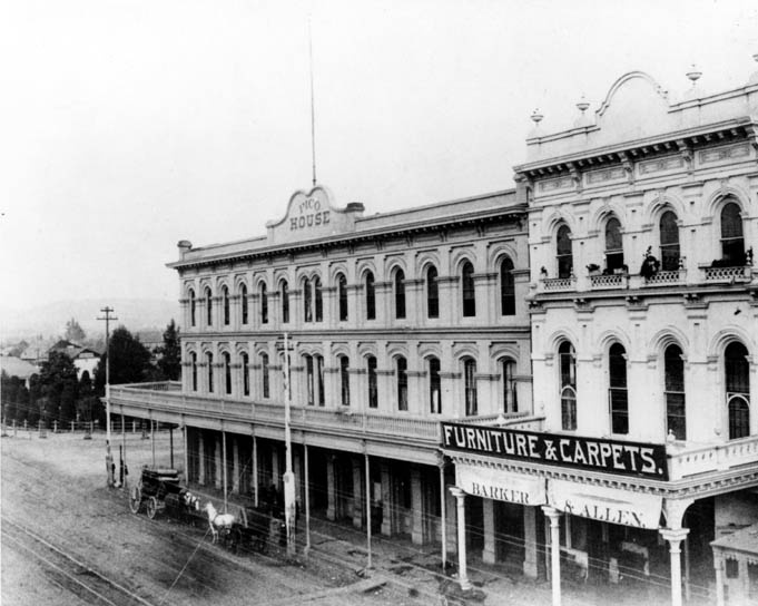
| (1891)** - The Pico House, sometimes called "Old Pico House", built by Pio Pico in 1869-70. The sign on 2 sides over the building here reads "Pico House" and horses and carriages are on an unpaved Main Street on the right side. Farther back on the right are the towers of Baker Block (built in 1878 and later torn down to make way for the 101 Freeway). |
 |
|
| (1890s)*#^ - View of Main Street looking northeast. The Plaza, Pico House, and Merced Theater are visible. A sign above the theater reads “Barker & Allen, Furniture & Carpets.” A stagecoach and horse-drawn wagon are parked in front of the Pico House. |
 |
|
| (ca. 1895)^## - View looking south on Los Angeles Street near Arcadia Street. Both the Garnier Block and Jennette Block are on the right. |
 |
|
| (ca. 1895)^## - Looking west on Arcadia Street from Los Angeles Street with Fort Moore Hill in the background. The three story Jennette building is on the northwest corner of Arcadia and Los Angeles Streets with Sanchez Alley running directly behind it up to the Plaza at Republic Street. Photo is misidentified. Aliso Street did not extend beyond Los Angeles Street. This is looking up Arcadia Street. |
 |
|
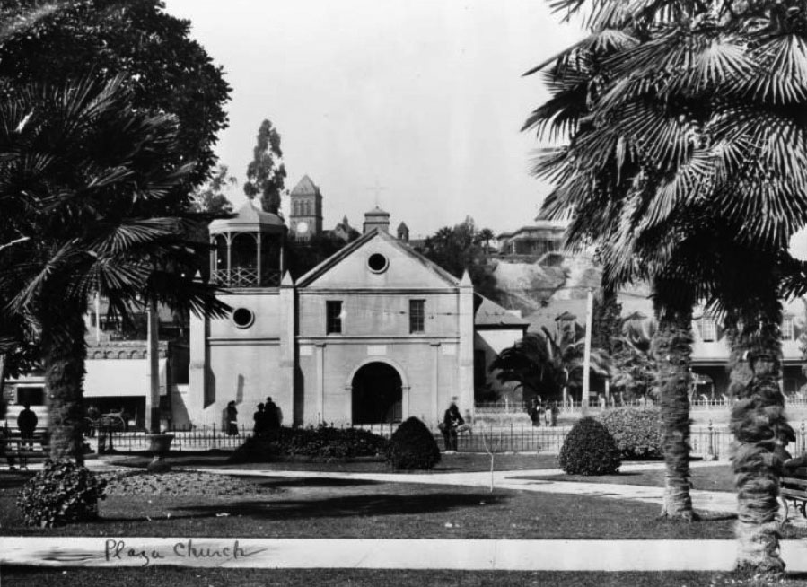
| (ca. 1890s)^*# - Front view of the Plaza Church standing across from the Plaza. Fort Moore Hill is in the background and the prominent Banning Residence can be seen at top-center, behind the Church. |
 |
|
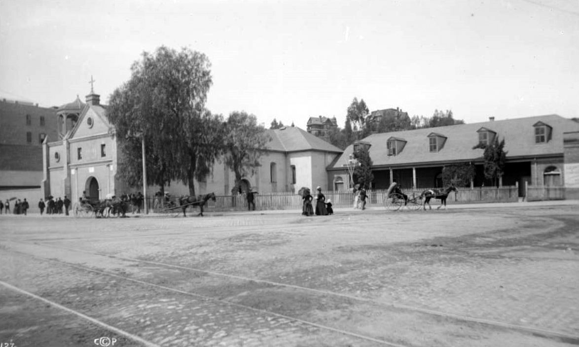
| (ca. 1900)*** - View of the Old Plaza Church as seen from the Los Angeles Plaza. The clock tower of Los Angeles High School can be seen in the background. |
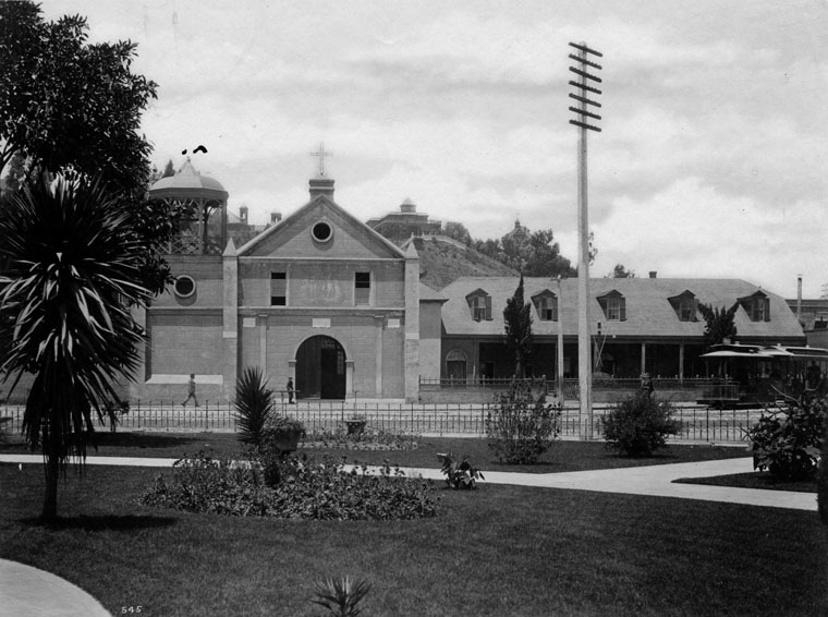
Historical Notes Los Angeles High School (seen above and behind the Old Plaza Church) was completed in 1891 at Castelar and Rock streets (North Hill Street and Fort Moore). It was built on part of the site of the abandoned Fort Moore Hill Cemetery, the first Protestant cemetery in Los Angeles, which was spread over the slopes of the hill. The four-story red brick building had 40 rooms for its 400 students. It was the second Los Angeles High School to be built and replaced the original one that was built in 1872, at the former site of Central School on what was then known as Poundcake Hill, at the southeast corner of Fort Street (later Broadway).** Early buildings commissioned to house the Los Angeles High School were among the architectural jewels of the city, and were strategically placed at the summit of a hill, the easier to be pointed to with pride. One of the school's long standing mottos is "Always a hill, always a tower, always a timepiece." In 1917, the school moved to its current location at 4650 West Olympic Boulevard (which incidentally is not on a hill).^* Click HERE to see more Early Views of Los Angeles High School. |
* * * * * |
More Historical Early Views
Newest Additions
Early LA Buildings and City Views
History of Water and Electricity in Los Angeles
* * * * * |
References and Credits
* DWP - LA Public Library Image Archive
**LA Public Library Image Archive
*^LA Fire Department Historical Archive
^^California Historical Landmark Listing (Los Angeles County)
#^Huntington Digital Library Archive
*#^LAPL-El Pueblo de Los Angeles Historical Monument Photo Archive
^#^El Pueblo de Los Angeles Historical Monuments Listing
^**UCLA-DWP Library Collection: Map of the City of Los Angeles as it Appeared in 1850
^*^Electric Railway History Association: The Street Railway History of Los Angeles
^*#Noirish Los Angeles - forum.skyscraperpage.com
^##California State Library Image Archive
^^^Metro - Los Angeles Transit History
**^History Matters: Calle de los Negros, 1880s
**#Metnews.com: ‘La Fiesta’ Is Annual Event in Late Victorian L.A.
*^#LA Times: What's in a name? A family's history, Sanchez Street, (4-5-2-10)
*#*Picture Gallery of Los Angeles History
#*^Flickr.com: Views of Los Angeles
#^*Flickr.com: Michael Ryerson
*^*LA Times: Los Angeles Street Name Origins
**^Blogdowntown: Hollywood Freeway
*^^Los Angeles Magazine: Zanja Madre 1868
^^*Los Angeles History Resources: Brunswig Building
*^^*KCET - El Aliso: Ancient Sycamore Was Silent Witness to Four Centuries of L.A. History; LA's First Streetcars
^*^#Facebook.com - Bizzare Los Angeles
^^^^US Department of the Interior: Vickrey-Brunswig Building
^#*^ElPueblo.lacity.org: Plaza Map
^#^*Nathan Masters: Los Angeles From the Air, 1887 vs. 2013
*##*Nuestra Señora Reina de los Angeles Asistencia Gallery
*^*^UCLA Libraries Special Collection: Pico House Courtyard
#*#*Los Angeles Conservancy: Vickrey-Brunswig Building
#^#^Chinese Los Angeles in 1870-1871 - Scott Zesch
^*Wikipedia: Pío Pico; Los Angeles Plaza Historic District; Hollywood Freeway; History of Los Angeles; The Church of Our Lady the Queen of Angels; Fort Moore; History of Los Angeles Population Growth; Olvera St.; Chinese Massacre of 1871
< Back